Author: Ben Castellani (Page 205 of 301)
Ben grew up in southwestern Pennsylvania and holds both a bachelor's and a master's degree in Meteorology, the latter being from CU Boulder. His hometown received nearly three feet of snow from the Storm of the Century back in March of 1993, sparking his initial interest in impactful weather. Ben currently works on remote sensing and data analysis software at NV5 Geospatial Software in Boulder.

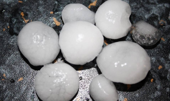
A recap of yesterday’s hailstorms, a discussion of today’s forecast which contains more hail, and a look at the eye of Category 4 Hurricane Bud from GOES-16.
Despite the first day of summer arriving on Thursday, it sure feels like mid-spring! Temperatures have dropped into the middle 50’s with low clouds, drizzle, and fog hanging around as of Monday morning. A frontal boundary has backed into northeast Colorado and will be major player in a wet start to our week, along with the potential for severe weather as well. We do have a few dry days in the extended forecast, however.
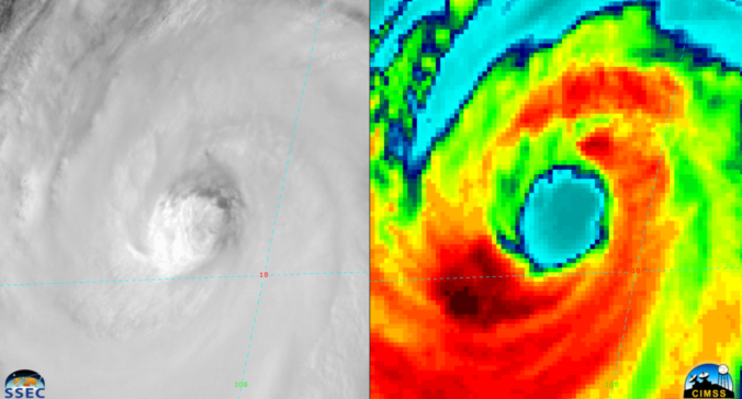
A favorable atmospheric set-up will help to funnel the remnants of Hurricane Bud, currently churning off the coast of western Mexico, into Colorado over the upcoming weekend. We discuss the impacts this will have for the Front Range and the rest of the state.

Live View of Boulder

Current Conditions

Live Radar

Recent Premium Posts

BoulderCAST Daily – Sun 05/10/26 | Cooler today but the 80s are not far behind
☀️ Sunshine and pleasant temperatures with upper 60s for our Sunday 🌡️ Trending …
BoulderCAST Daily – Sat 05/09/26 | Watching some late-day showers ahead of a cold front tonight
🌧️ Scattered showers this afternoon and evening ahead of a cold front setting …
BoulderCAST Daily – Fri 05/08/26 | Warmer weather takes hold
☀️ Warmer and calmer skies ahead: Expect lots of sunshine from the upper …
3-Day Forecast

Trending Content

© 2026 Front Range Weather, LLC