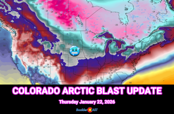
This weekend’s forecast looks nothing like the mild stretch we’ve been coasting through so far in 2026. A sharp pattern shake‑up is finally knocking on eastern Colorado’s door. An Arctic airmass is set to spill into the Front Range Thursday night, bringing the coldest temperatures of the season and eventually a round of light, fluffy snow. We break down the timing, impacts, and just how low those temperatures will go—plus why the rest of the country is gearing up for a far bigger and historic winter storm.
What You Need to Know
- 🥶 Arctic air finally arrives — After weeks of abnormal warmth, a true Arctic airmass will surge into eastern Colorado Thursday night, ending our mild streak.
- 🌬️ Slow, dense cold intrusion — The front oozes in from the east with no dramatic passage; a reinforcing surge Sunday keeps the Front Range frozen through the weekend.
- 📉 Coldest stretch of the season — Highs in the teens Friday–Sunday, widespread subzero lows Saturday night
- 🌨️ Light, fluffy snow — Moisture is limited, but high snow ratios mean a dusting to 3 inches of accumulation for Friday into Saturday, highest near the Foothills; another minor round of snow is possible on Sunday but is more uncertain.
- 🧊 Hazardous cold east of Denver — A Cold Weather Advisory is in effect for the eastern Plains with wind chills as cold as –20°F (NOT including Boulder/Denver).
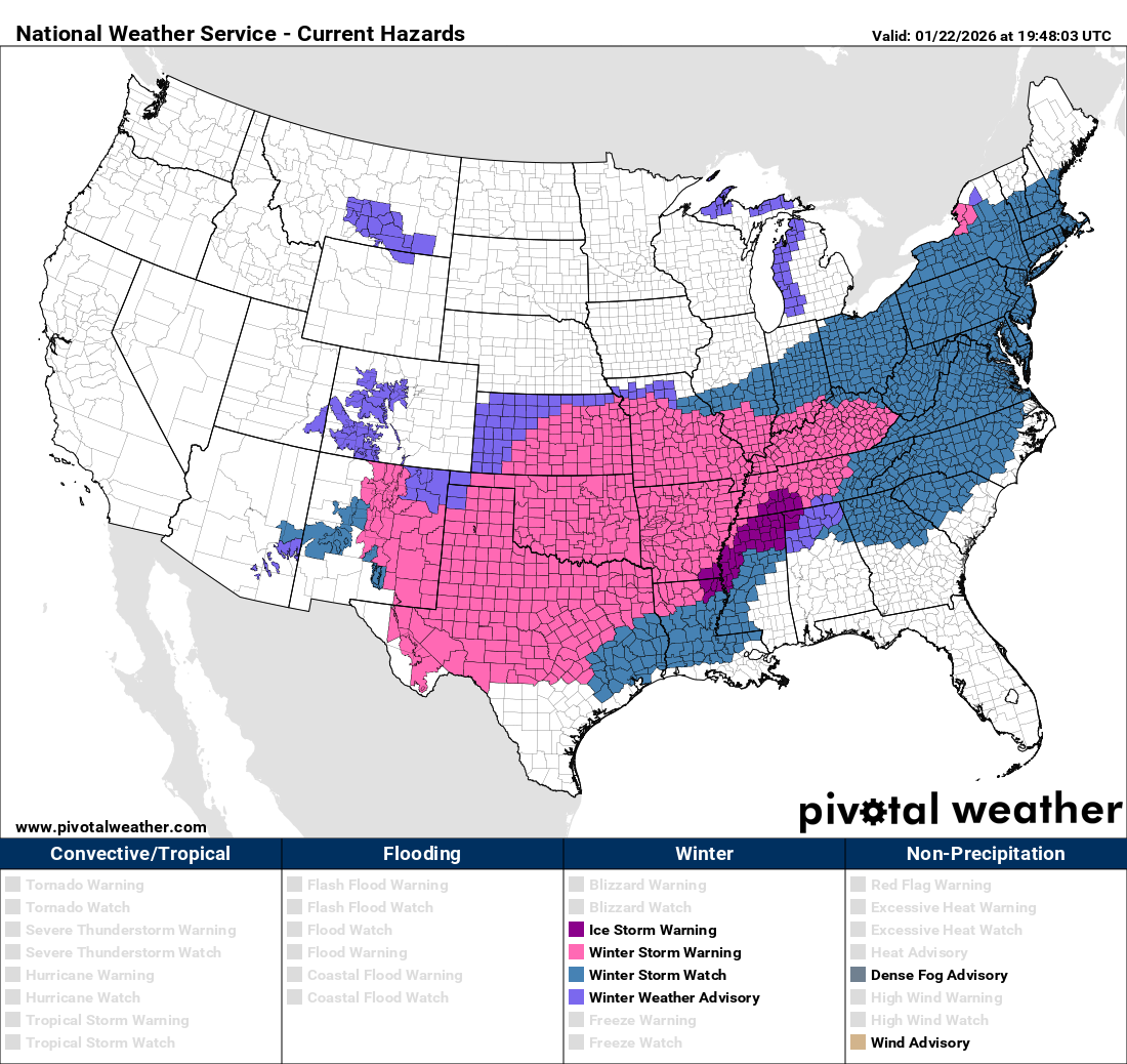
- 🌎 Major national winter storm — While Colorado stays on the sidelines, a powerful coast‑to‑coast system will bring heavy snow and ice from New Mexico to Maine. This storm will likely be remembered for years, if not decades, for its breadth and magnitude of impacts on the nation.

Go Premium, get all the perks.
Daily Forecast Updates
Get our daily forecast discussion every morning delivered to your inbox.
All Our Model Data
Access to all our Colorado-centric high-resolution weather model graphics. Seriously — every one!
Ski & Hiking Forecasts
6-day forecasts for all the Colorado ski resorts, plus more than 120 hiking trails, including every 14er.
Smoke Forecasts
Wildfire smoke concentration predictions up to 72 hours into the future.
Exclusive Content
Weekend outlooks every Thursday, bonus storm updates, historical data and much more!
No Advertisements
Enjoy ad-free viewing on the entire site.
First Arctic blast of the season
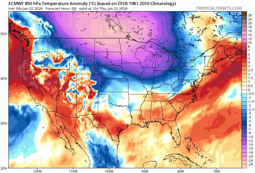
Much like the final month of last year, the opening stretch of 2026 has been astonishingly warm across the Front Range. We’ve stacked up far more unseasonably mild days than climatology would ever suggest is reasonable for January. The High Plains and northern Rockies have been the epicenter of this warmth, running some of the most anomalous temperatures in the entire country through the first three weeks of the New Year. You practically need a magnifying glass to find any region of the Lower 48 running below normal during this period.
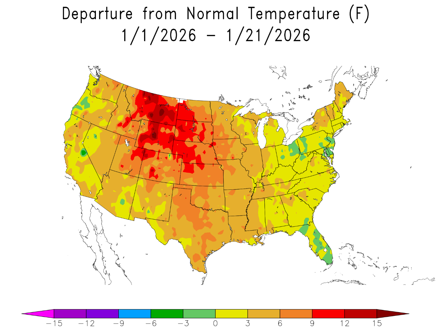
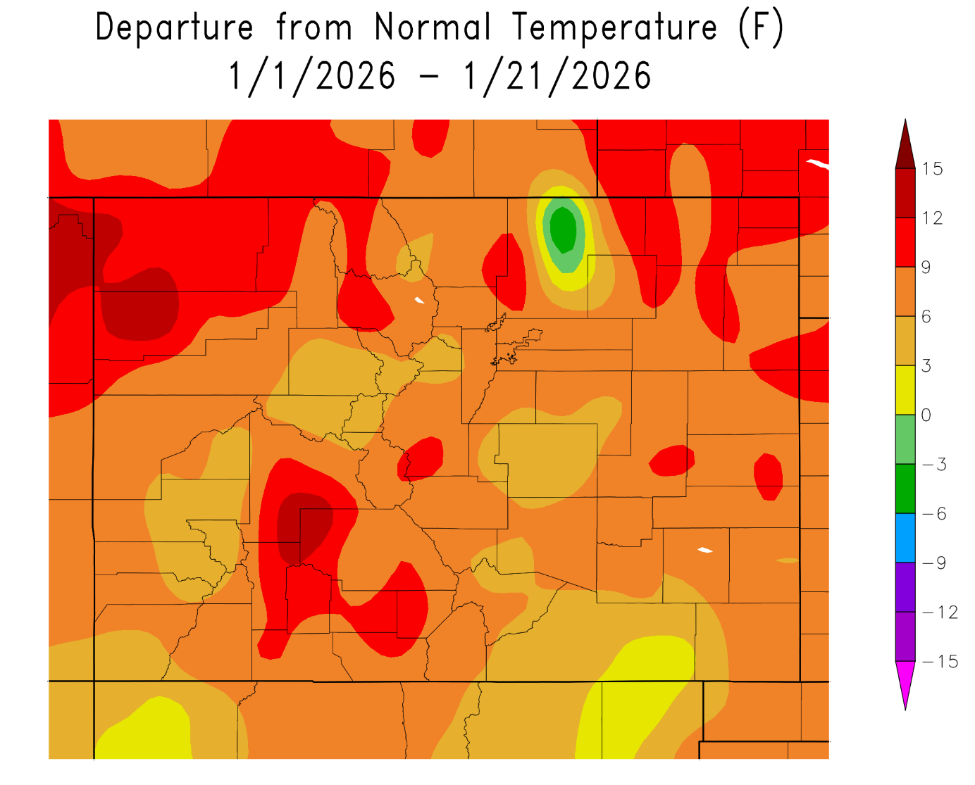
Here along the Front Range, Boulder and Denver are sitting roughly 7–10°F above average year-to-date, right in line with the rest of Colorado. Even with a couple of light snow events sprinkled in, the overarching theme has been exceptional warmth and a persistent lack of snow or true cold.
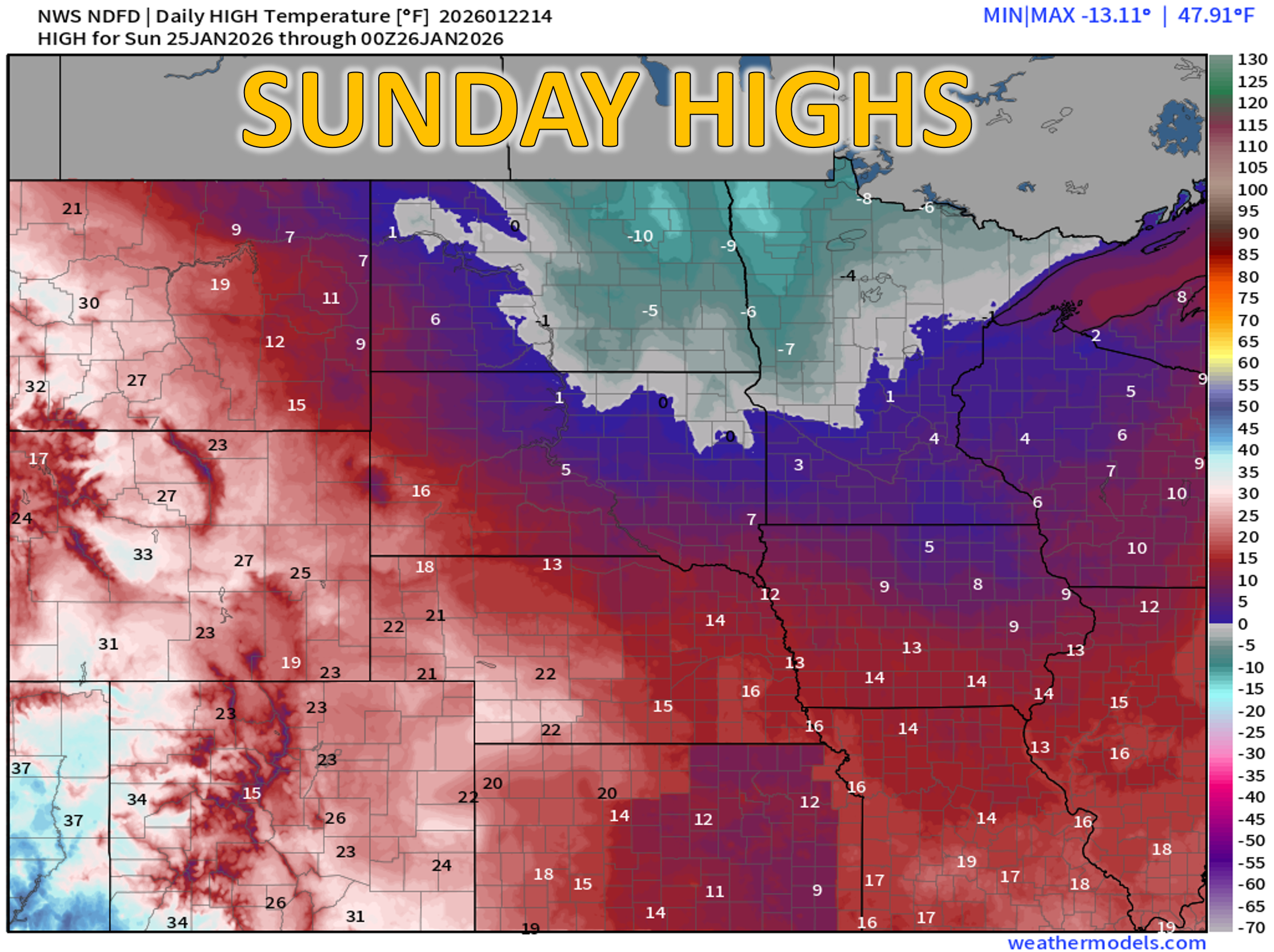
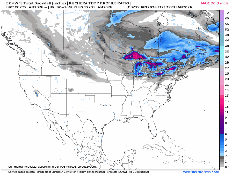
As we outlined in Monday’s weekly outlook, that warm streak is about to hit a brick wall. A bona fide Arctic airmass—something that has repeatedly not made it into Colorado all winter—will finally take a direct aim at eastern Colorado beginning Thursday evening. Up until now, the coldest air of the season has consistently plunged into the Midwest and Great Lakes, leaving us on the mild western fringe of things. As of Thursday morning, the leading edge of the cold front is draped across the Dakotas and preparing to surge south.
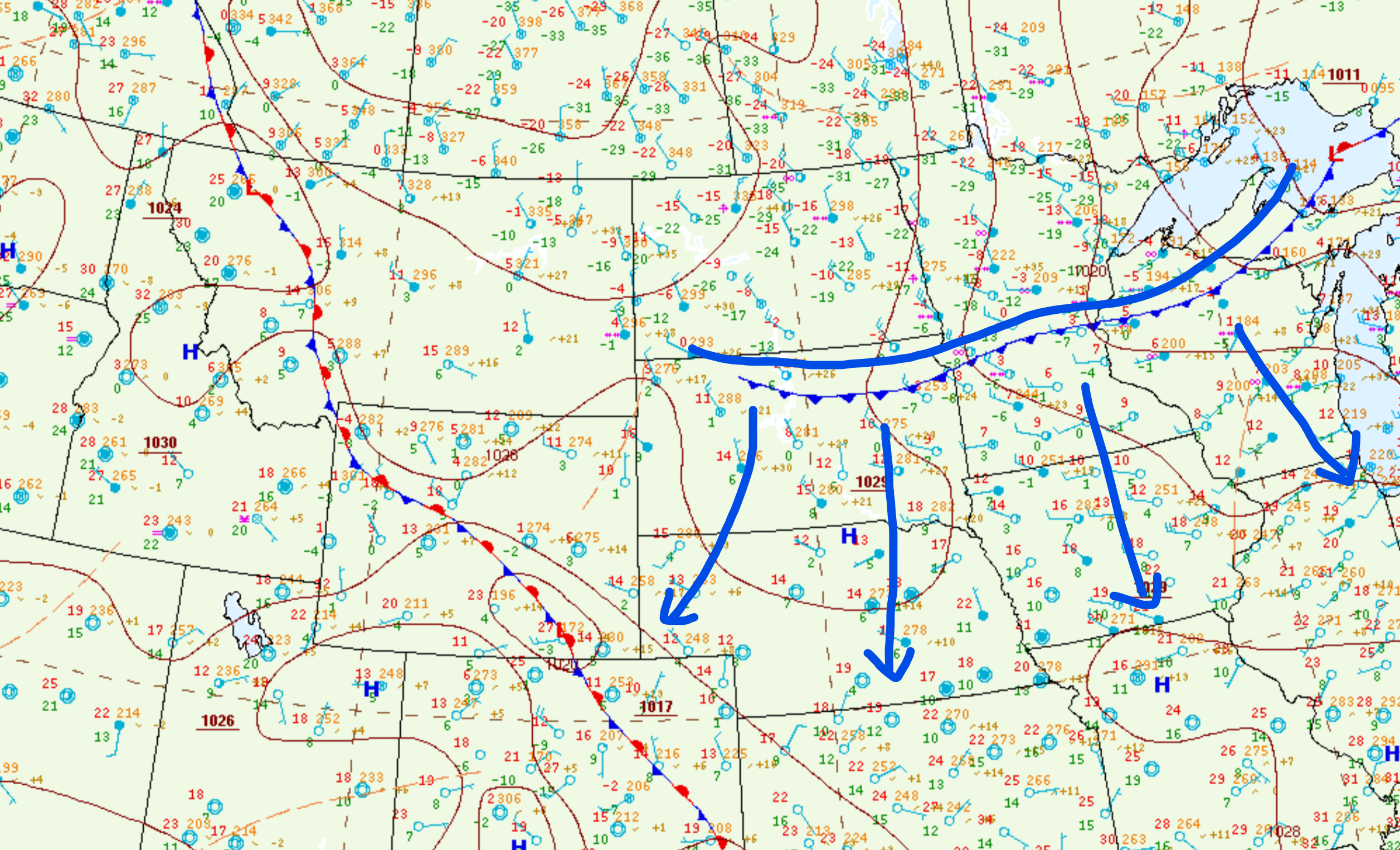
Arctic front location as of Thursday morning
This Arctic air will ooze southward through the day Thursday, eventually backing into the Boulder–Denver corridor from the east Thursday night. This won’t be a dramatic frontal passage with howling winds and a sudden temperature crash. Instead, expect a slow, methodical intrusion of cold air creeping into the area late Thursday evening and continuing into early Friday morning. A secondary reinforcing surge of even colder air is slated to arrive later in the weekend, ensuring the Front Range stays firmly frozen through at least Sunday night. Yes, there will be snow, but not much (we’ll talk about this in a moment). The real headline is the bitter cold—easily the coldest stretch of this unusually warm winter season so far.
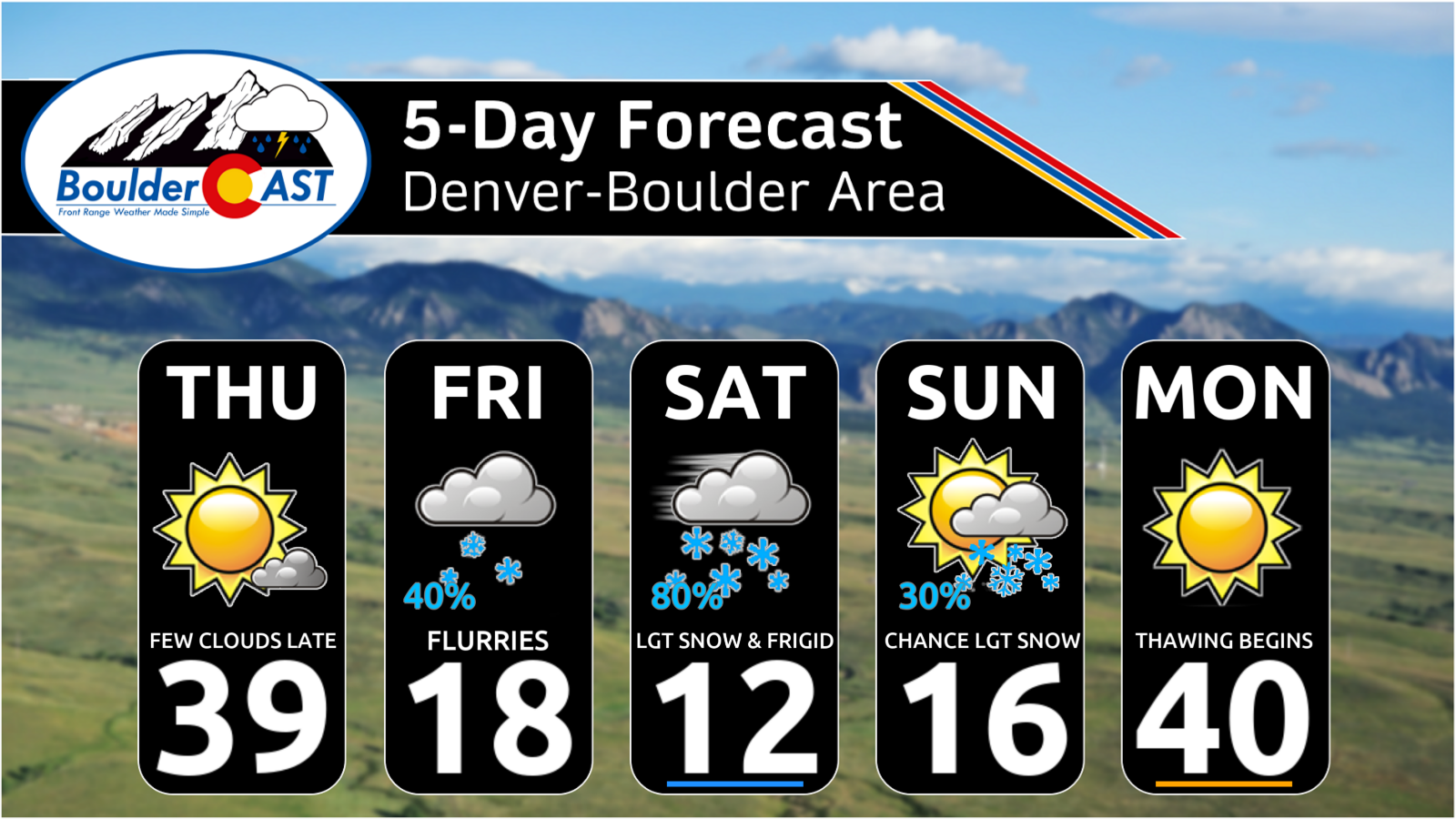
Thursday: The Transition Day
Thursday will feel noticeably cooler than recent days, but still pleasant by January standards. Highs should reach the upper 30s under mostly sunny skies. Enjoy it!
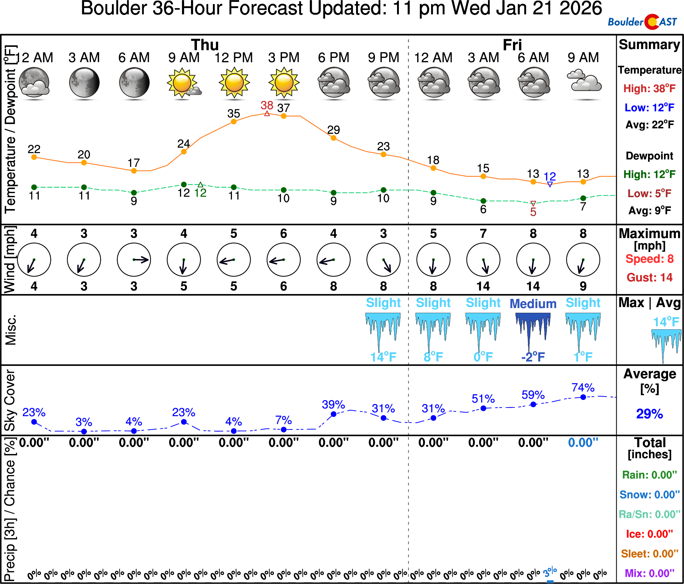
Friday: Arctic Air Takes Hold
By sunrise Friday, the cold air will be entrenched across the region with lows near 10°F—but this is just an appetizer.
Most models continue to flirt with the idea of a Denver Cyclone developing Friday afternoon, which could temporarily scour out the coldest air across the southern Metro and allow highs there to climb into the 20s.
While a weak cyclone is plausible, guidance is almost certainly overdoing its strength and coverage. Boulder and the northwest Metro area will remain locked into the cold regardless, with highs only in the teens. Some parts of south/east Denver will reach the 20s.
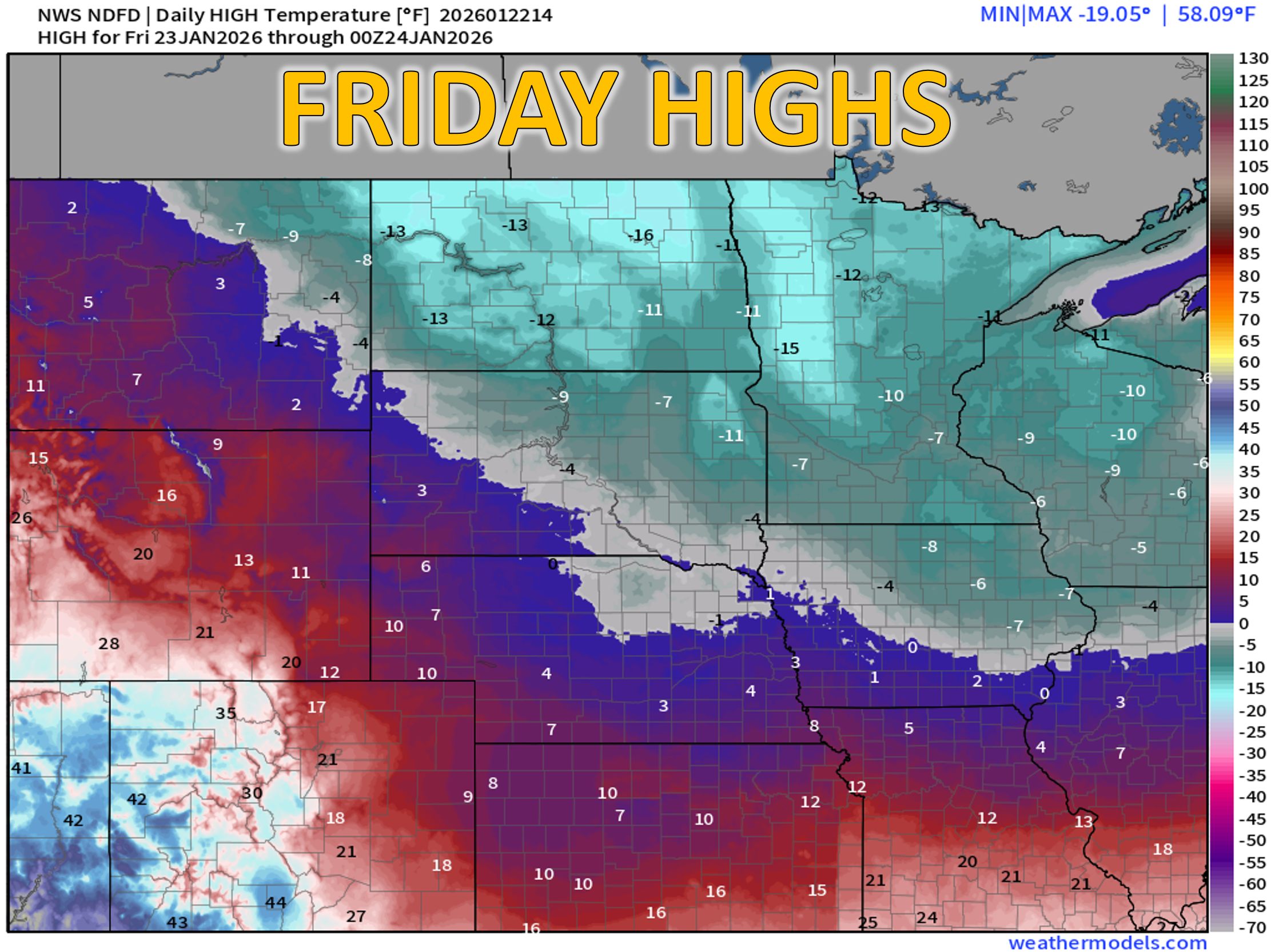
Friday night, temperatures drop into the single digits, with a few favored low‑lying spots dipping slightly below zero. Cloud cover and light snow will help prevent a freefall in our readings.
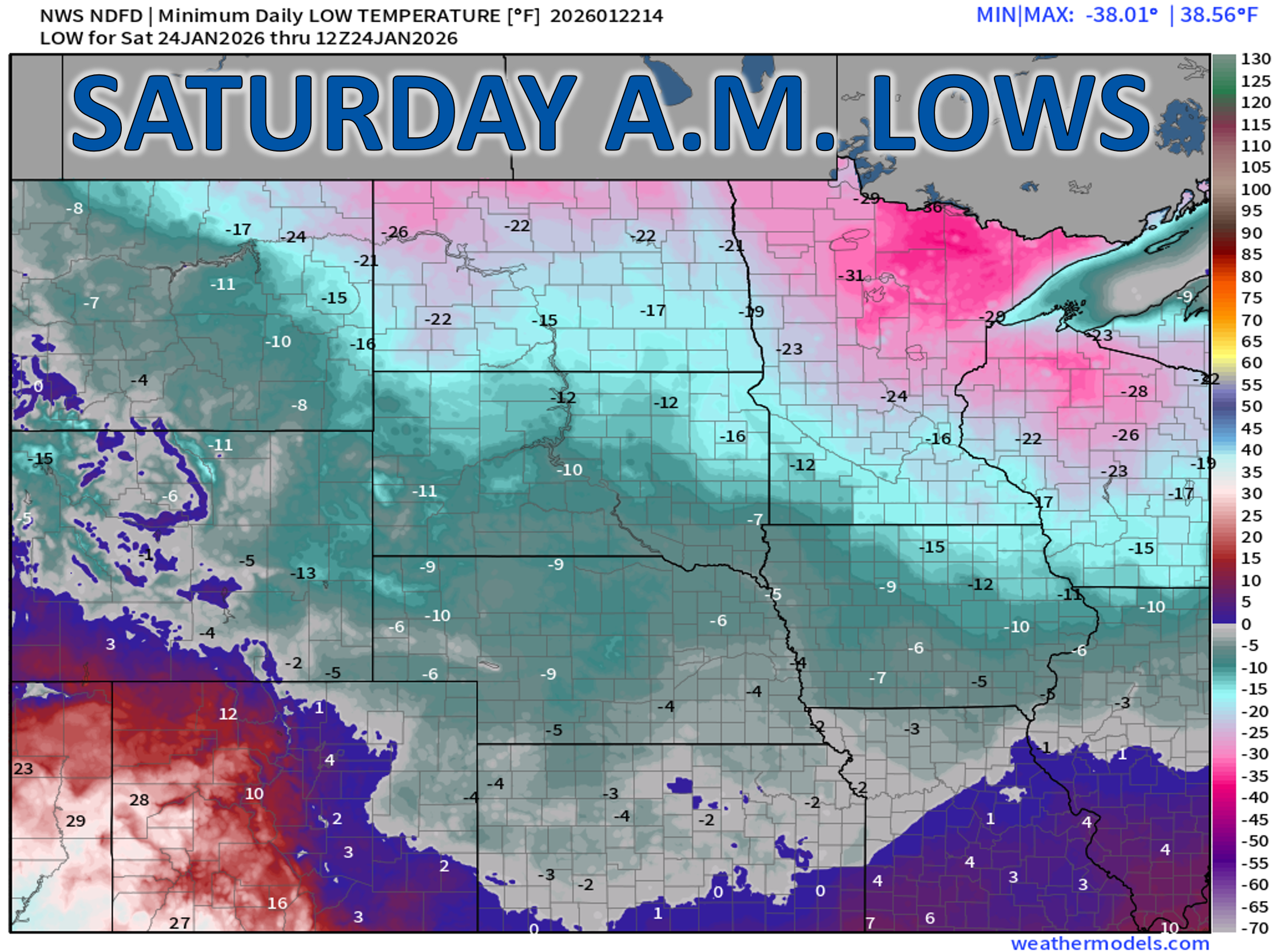
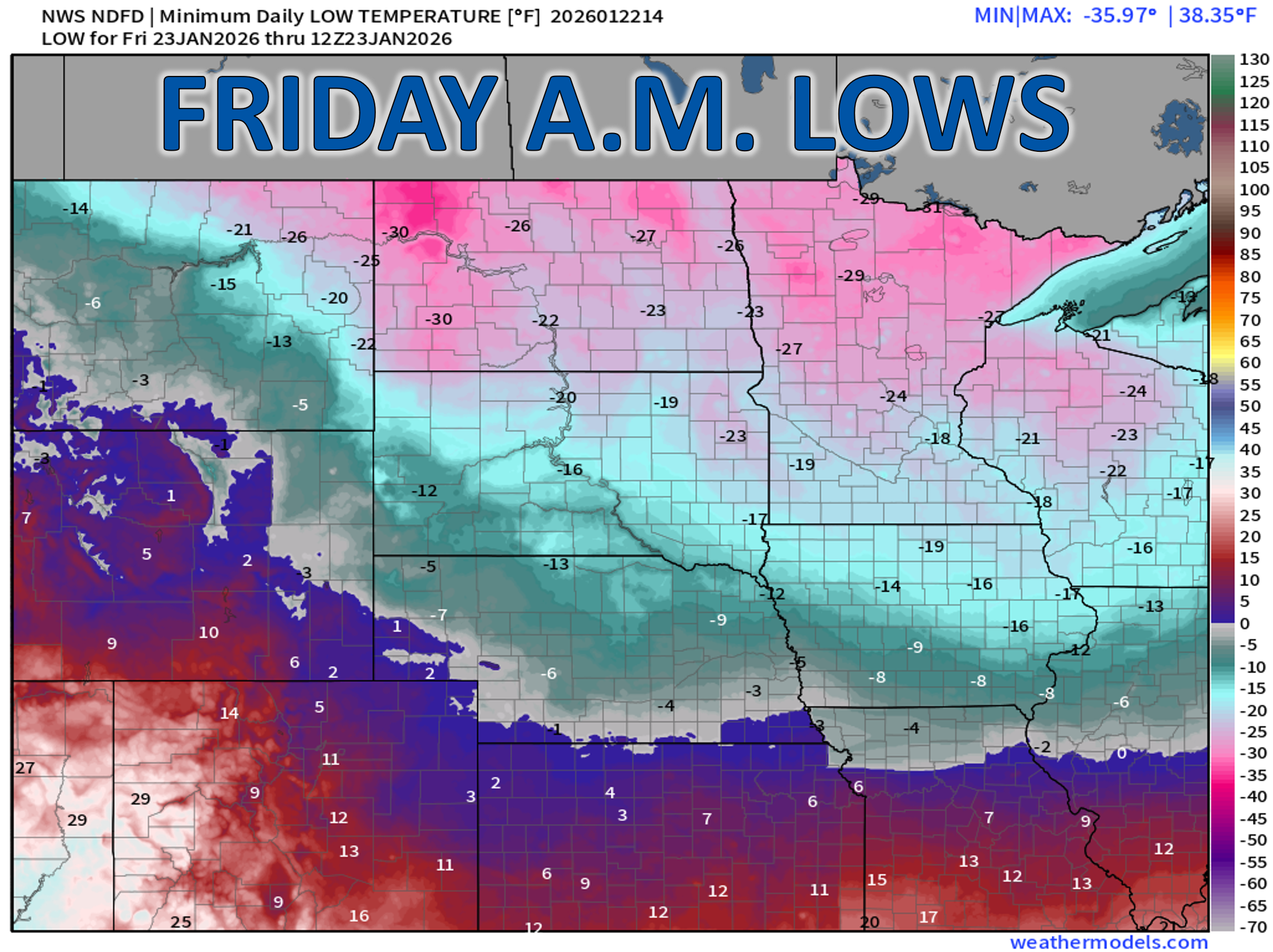
Saturday: The Deep Freeze
Saturday remains bitterly cold with highs only in the low to mid teens across Boulder and Denver. The Arctic airmass will be fully established, and this probably lands as the coldest day of the outbreak.
Skies should clear Saturday night, and with fresh snow on the ground, radiational cooling will be extremely efficient. Expect the coldest night of the entire event: widespread subzero lows, generally –1 to –8°F, with the usual cold pockets flirting with –10°F or colder.
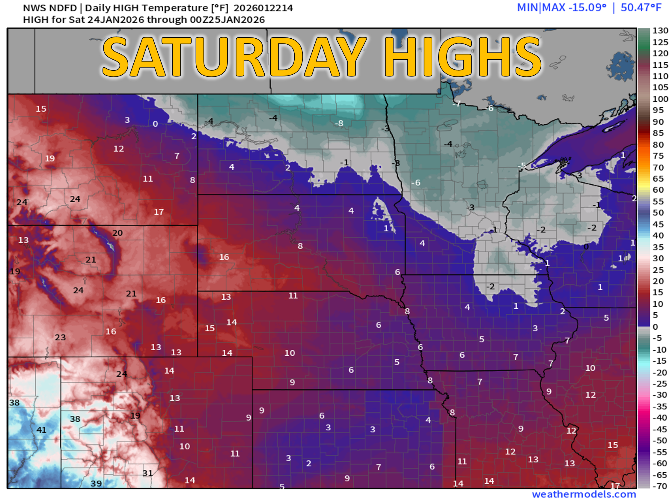
Sunday: Reinforcing Cold Surge?
Forecast confidence is improving for Sunday, and most models now agree on a secondary push of Arctic air sliding south across the High Plains during the day. This will spill into eastern Colorado and reinforce the cold, though not to the same intensity as Saturday. Highs should be a tad warmer in the mid teens to lower 20s, with at least partial sunshine through the day.
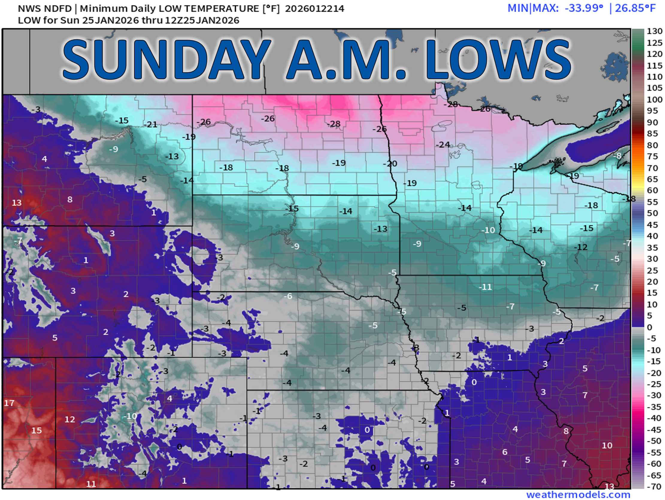
Sunday Night into Monday: Thawing Out?
The endgame of this winter blast remains fuzzy. Depending on how quickly the Arctic air retreats, temperatures Sunday night may either:
- Rise overnight as downslope flow begins, or
- Remain near or below zero if the cold dome hangs on longer.
Either way, Monday looks dramatically warmer with downslope returning and highs in the mid 30s to mid 40s—a jarring but welcome swing that will feel downright balmy.
Cold Weather Advisory for eastern Colorado
The National Weather Service has issued a Cold Weather Advisory (formerly known as a Wind Chill Advisory) for the eastern Plains from 3 AM Friday through 9 AM Sunday, where wind chills may plunge to –20°F. This does not include Boulder or Denver, where winds will be lighter and temperatures slightly higher.
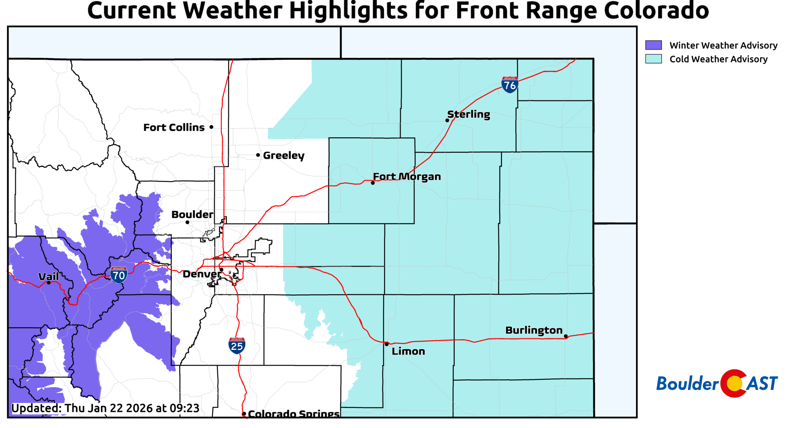
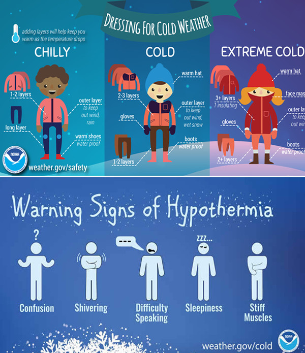
Still, it will be a legitimately cold weekend—especially given how absent winter has been so far. If you must be outside in the cold, be sure to dress for it!
Snow Potential: A Little Bit of Fluff
Alright, with the cold talk out of the way, let’s briefly discuss the snow potential.
The main window for accumulating snow runs from late Friday afternoon through Saturday morning, when 0.05″ to 0.25″ of liquid is on the table—highest in and near the Foothills, lowest across the northeastern Metro area. A secondary, very light round of snow may accompany Sunday’s reinforcing cold surge.
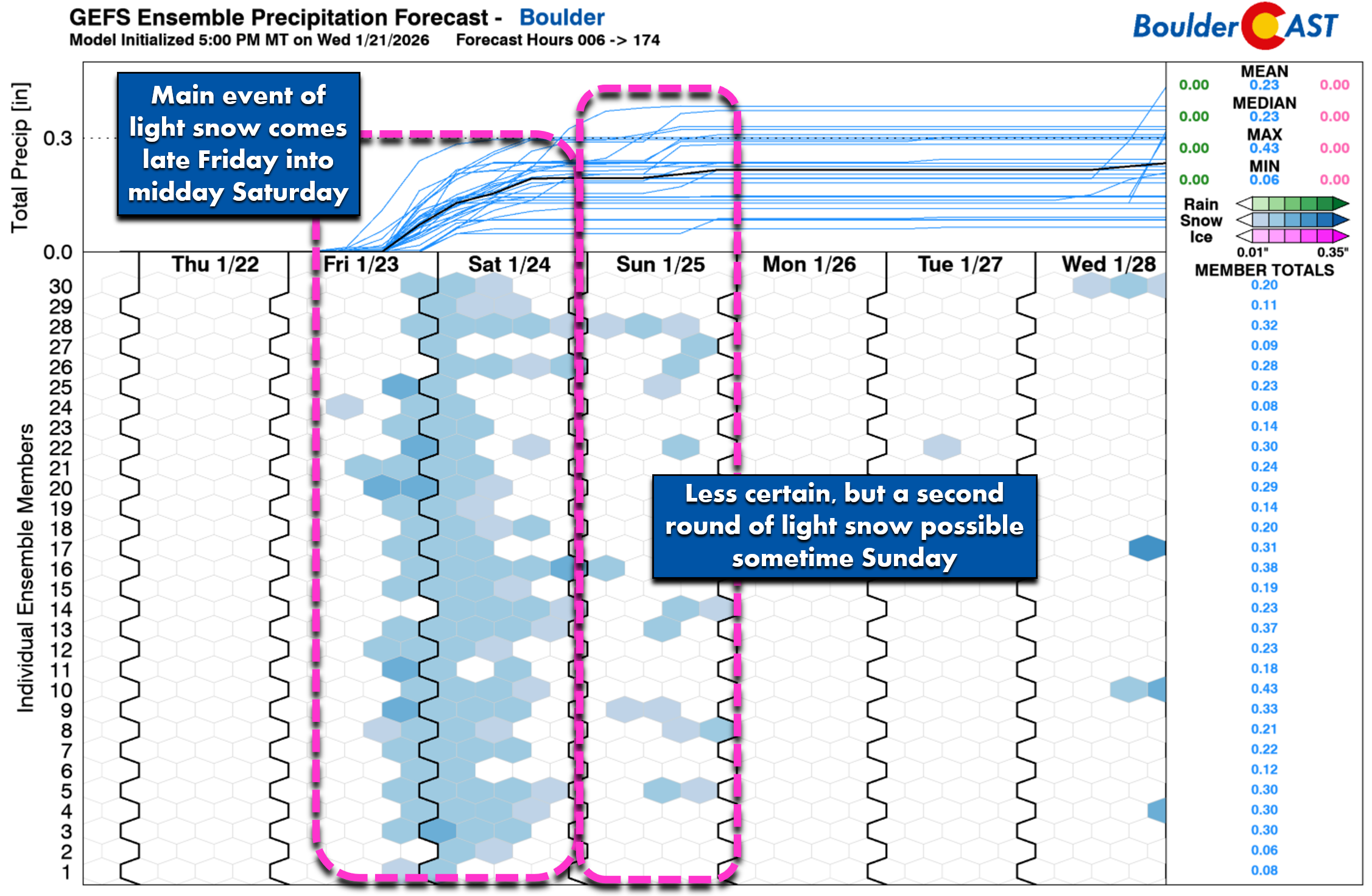
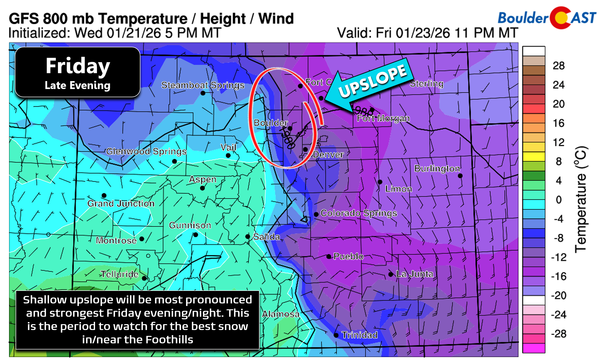
Moisture is meager with this Arctic airmass, so we’re not expecting a ton of snow to fall out of it. Precipitation amounts around 0.05 to 0.25″ are possible Friday into Saturday, with the highest amounts in/near the Foothills where shallow upslope of the dense Arctic air will do its best work.
Upslope-favored locations could see very light snow persist for more than 18+ hours (late Friday afternoon into Saturday lunchtime). The best period of upslope aligns during Friday night where snowfall rates could exceed—*gasp*— 1/4″ per hour at times.
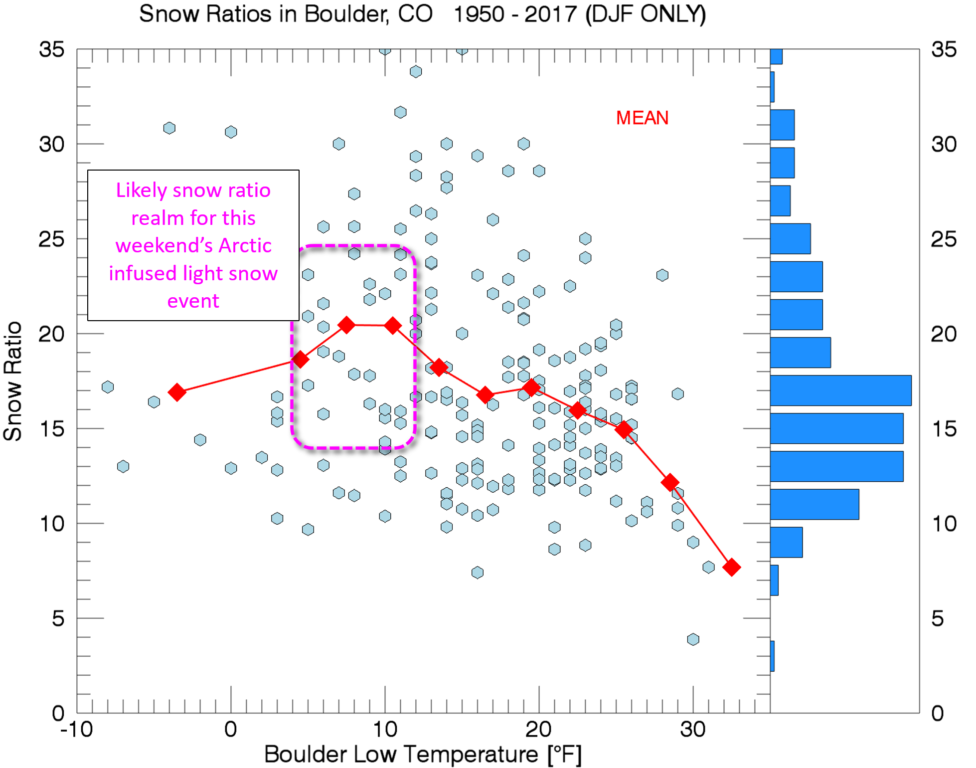
Given the very cold temperatures, we’re expecting snow ratios to land around 20:1 for this event. Thus, even that small amount of moisture we get will translate into a serviceable amount of fluffy snow.
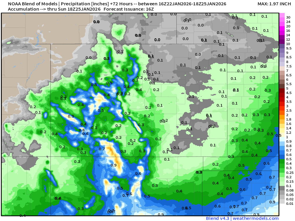
Our snowfall forecast map for the first and primary wave of light snow is shown below, covering all snowflakes on Friday through Saturday evening. In general, we’re expecting a dusting to 4 inches of fluffy snow to accumulate, with the higher end totals occurring in and near the Foothills, including Boulder. Some areas north and east of Denver may see as little as just a trace or dusting of snow.
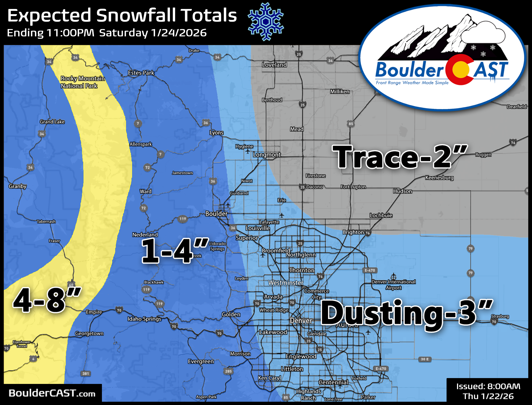
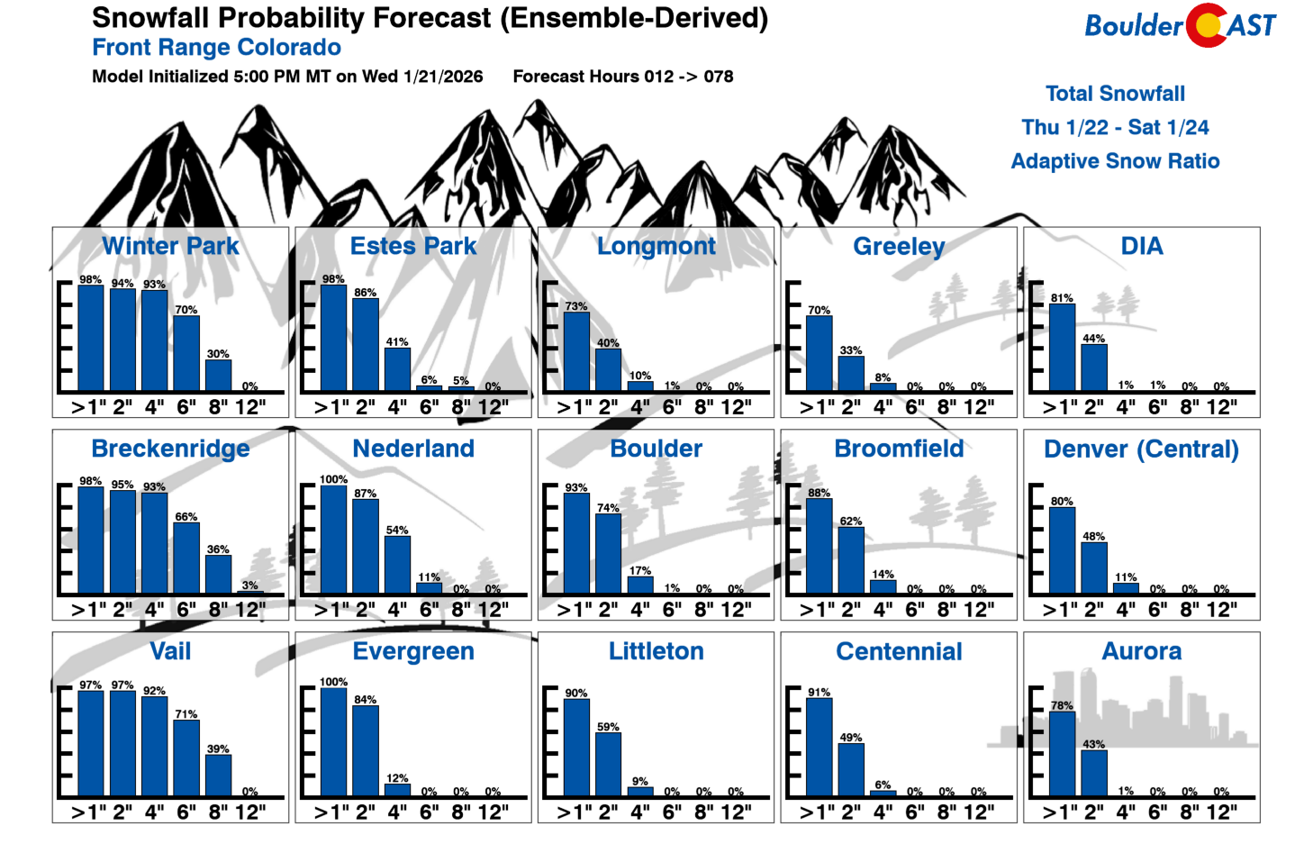
Our latest Snowfall Probabilities give most of the Front Range a good shot at picking 1 to 2 inches of snow, but little hope to see much more than that. Boulder leads the way across the lower elevations with just a 17% chance to see more than 4 inches of snow.
Uncertainty still shrouds the potential second wave of light snow on Sunday, but as of writing Thursday morning, it looks like a very minor and quick-hitting snow event with 1″ or less favored for our area. Right now, it’s no big deal, other than continuing the wintry vibe through the end of the weekend.
Beyond Colorado: An Historic Winter Storm for the Nation
Outside of Colorado, this Arctic outbreak will be a much bigger issue for the rest of the country as a massive winter storm sweeps across the nation producing widespread heavy snow and crippling freezing rain where Gulf moisture will overrun the dense Arctic air. Snow totals of more than one foot are possible along a swath stretching more than 2000 miles from New Mexico to Maine in the coming days creating extensive travel disruption nationwide. This could very well go down as one of the legendary winter storms remembered for years to come, if not decades, similar to 2010’s Snowmaggeddon or 1993’s Storm of the Century. Meanwhile, here in Colorado, we will be watching this monster from the sidelines—only fitting for how this winter has unfolded so far.
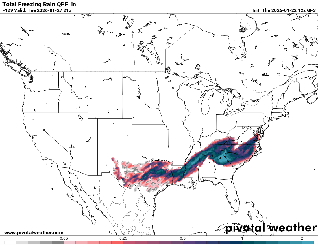
Forecast ice accumulation from the GFS model (freezing rain thickness)
The Winter Storm Watch and Warning zone for this one is almost comically large!
That’s the latest for now. If anything meaningful changes, we’ll pass along an update here or on social media. Make sure you are subscribed. Stay warm and safe as this Arctic outbreak unfolds and enjoy the small amount of snow.
Spread the word, share our crazy Colorado weather:
Go Premium, get all the perks.
Daily Forecast Updates
Get our daily forecast discussion every morning delivered to your inbox.
All Our Model Data
Access to all our Colorado-centric high-resolution weather model graphics. Seriously — every one!
Ski & Hiking Forecasts
6-day forecasts for all the Colorado ski resorts, plus more than 120 hiking trails, including every 14er.
Smoke Forecasts
Wildfire smoke concentration predictions up to 72 hours into the future.
Exclusive Content
Weekend outlooks every Thursday, bonus storm updates, historical data and much more!
No Advertisements
Enjoy ad-free viewing on the entire site.


You must be logged in to post a comment.