One thing is for sure, a prolonged period of cold and unsettled weather will take hold of the Front Range Wednesday morning into Friday. A mash-up of rain, snow, and freezing drizzle will intermittently impact the area during this timeframe. Overall precipitation rates will be light, but the long duration could lead to light snow accumulations by Friday morning. In this update, we talk tumbling temperatures, rain/snow/ice timing, and potential snow accumulations.
*PREMIUM* STORM UPDATE (7:00 AM Thu 11/21): Don’t be fooled by the lull in the action… There is still more light snow to come! READ HERE
We discuss Boulder and Denver weather every single day on BoulderCAST Premium. Sign up today to get access to our daily forecast discussions every morning, complete six-day skiing and hiking forecasts powered by machine learning, access to all our Front Range specific weather models, additional storm updates and much more!

A big mess in the Southwest
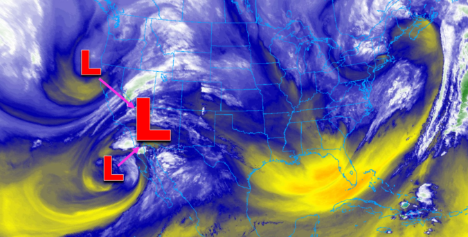
The beautiful conditions we’ve had the last four days are about to come to an end. As we speak, two potent storm systems are already coming together to our south and west:
- A relatively warm slow-moving low pressure rich in sub-tropical moisture off the Mexican coastline
- A cool and somewhat moist trough digging into California from the north
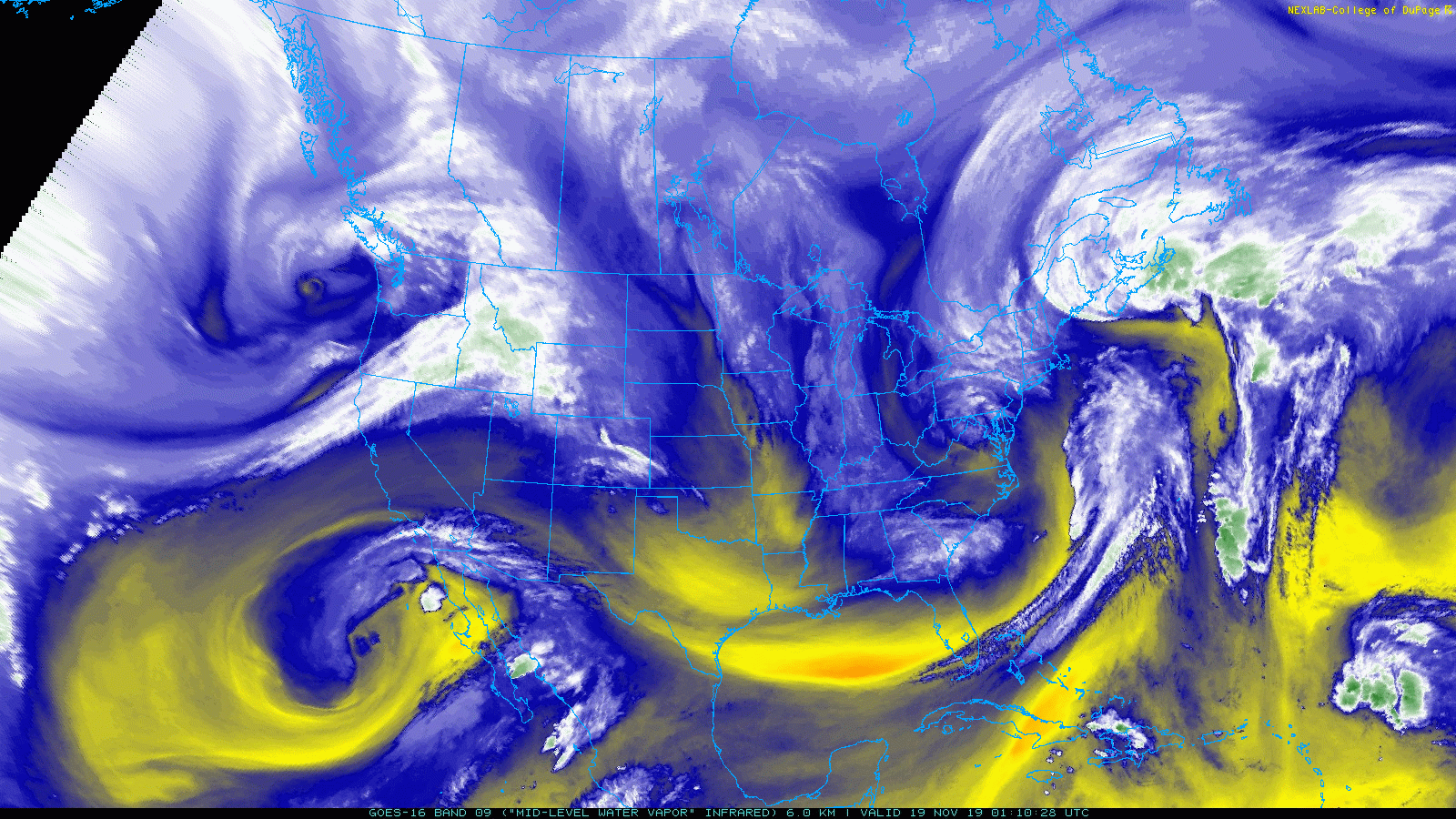
GOES-East mid-level water vapor animation from Thursday morning and afternoon. Two storms are merging across California/Arizona.
The two systems will interact to produce widespread precipitation across the entire Four Corners region over the next few days. Large areas will see greater than 1″ of rain, with more than a foot of snow in the higher Mountains.
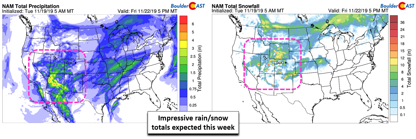
NAM total precipitation forecast (left) and snow forecast (right) through Friday evening
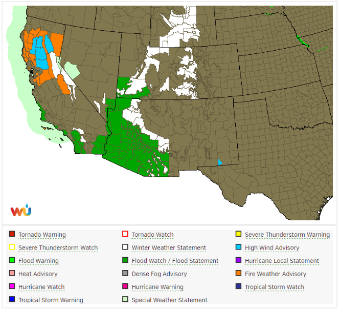
Thunderstorms and persistent rainfall don’t mix well with desert landscape. Flash Flood Watches are posted for much of Arizona, but also parts of California, Nevada, and Utah…locations where heavy rain is already falling Tuesday evening. Winter Storm Watches and Warnings cover the higher elevations in the same states, but also include areas further north in western Colorado and Wyoming.
The San Juans in particular are favored in this scenario and will get hammered with snow: 1 to 2 feet is expected through Wednesday and Thursday. Considering the current state of snowpack in southern Colorado, this is just what the doctor ordered!
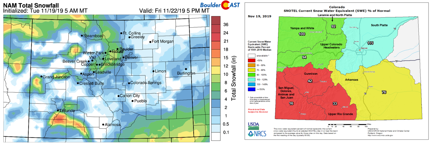
NAM model-derived total snowfall forecast through Friday (left) and Colorado observed current snowpack (right)
By Friday, Mt. Crested Butte will be covered in fresh snow. Right now it’s shockingly barren for mid-November.
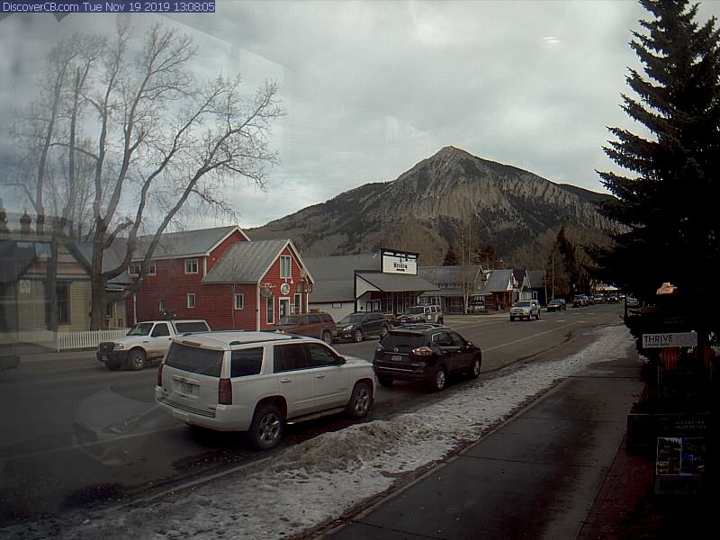
Pre-storm clouds filled the skies in Crested Butte Tuesday afternoon
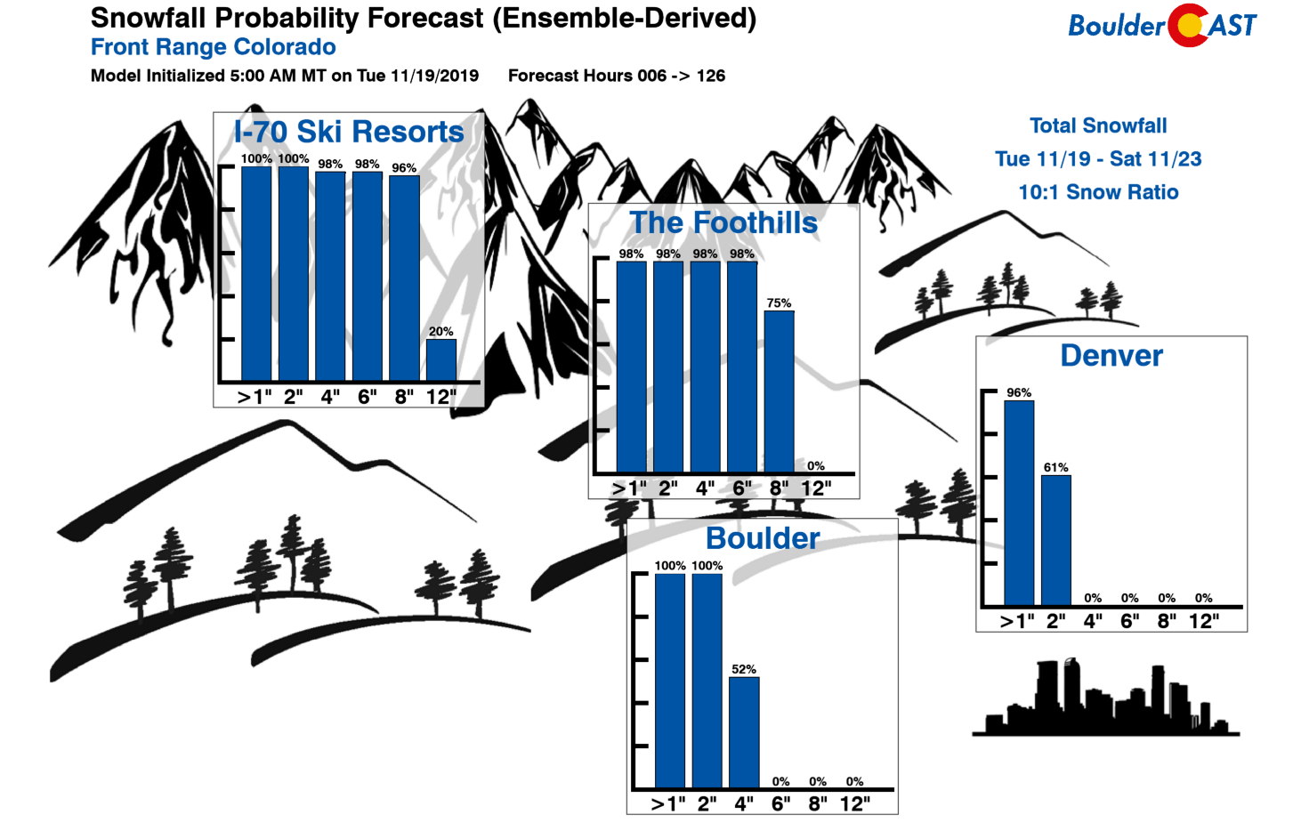
Below is our quicklook forecast for snow expected on Colorado’s slopes the next six days. A healthy dumping of powder is shaping up for Wolf Creek, Telluride, and Purgatory alike. The I-70 resorts will see less, but still somewhere in the 4 to 8″ range.
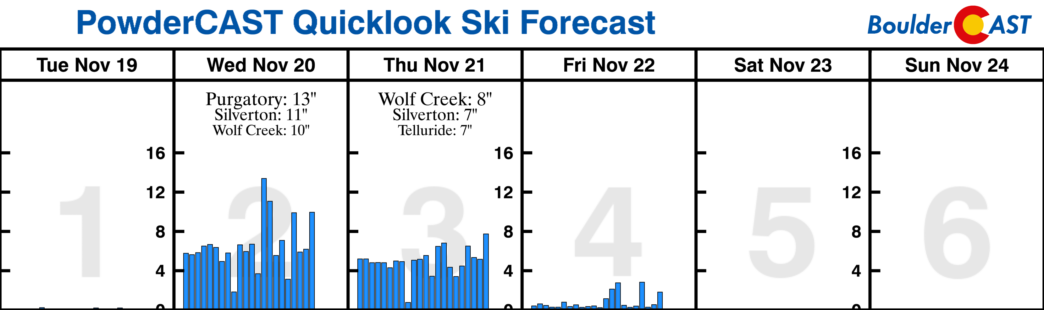
PowderCAST quicklook snowfall forecast through Sunday
Mountain snow confirmed! Front Range weather less certain…
Considering the juicy pipeline of sub-tropical moisture pumping into the Four Corners region (see below), it’s a relatively straight-forward forecast for areas west of the Continental Divide. However, for the Denver Metro area, it’s anything but an easy forecast.
NAM model precipitable water anomaly forecast animation covering Tuesday into Thursday night. A surge of sub-tropical moisture is evident.
There are numerous factors to consider which will ultimately determine how much precipitation we see, and more importantly, how much of it will fall as snow….
- The above animation gets us excited for the incoming sub-tropical moisture! But don’t be deceived…most of it won’t make it to our region as it will be “wrung out” by the many mountain ranges upstream
- The best large-scale lift from the storm complex will be south and west of our area with only intermittent pulses of energy moving across northern Colorado both Wednesday and Thursday. Some of the biggest snowstorms in Boulder’s history have resulted from slow-moving “Four Corners Lows”. Unfortunately, the this one will be more of a “Las Vegas Low”. While that may sound a little more risqué, the shift west will take the best snow with it.
.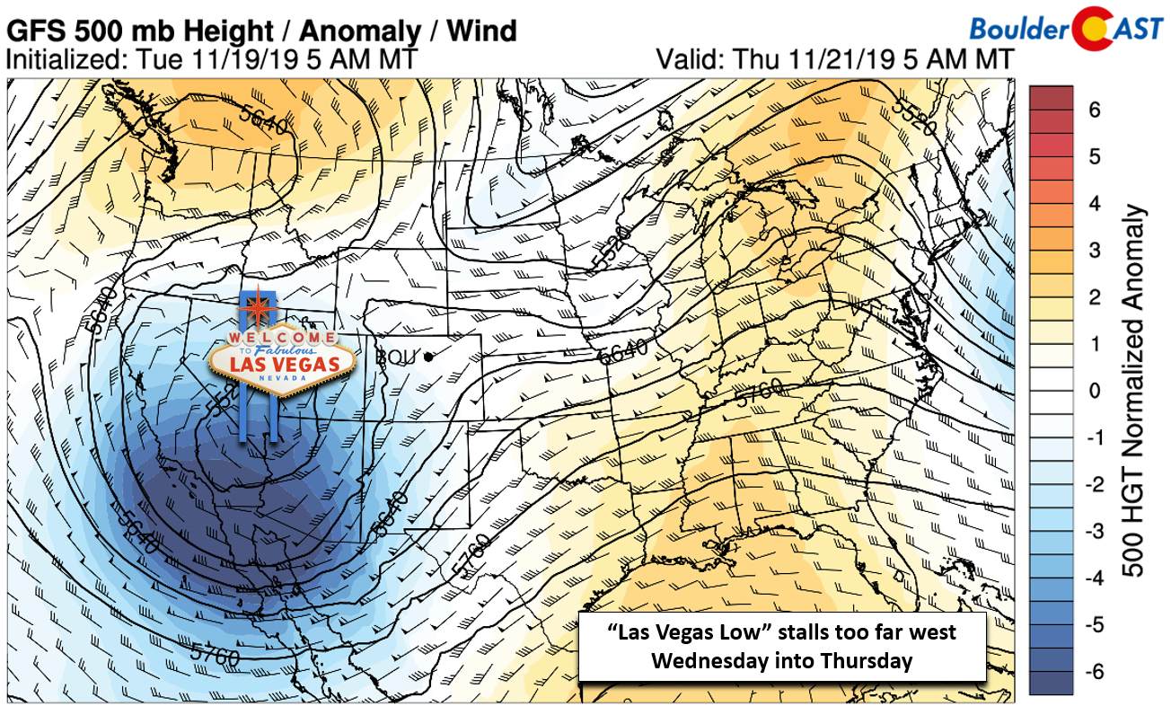
GFS 500 mb height anomaly forecast for Thursday morning. Is that a “Las Vegas Low”?
- Temperatures early Wednesday will initially be too warm for snow, so it’ll definitely be starting as rain. As the day wears on, rain will mix with snow and eventually change to all snow by late afternoon or early evening…just in time for the evening commute! Depending on the intensity of the rain/snow at this juncture, change-over timing could be vital in snow amounts early-on. Temperatures fall below freezing near sunset Wednesday and remain there into Friday morning…a far cry from the 60’s we’ve had Monday and Tuesday this week.
.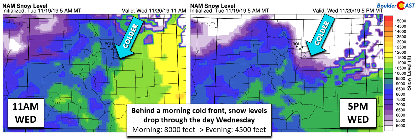
NAM model-derived snow level forecast for Wednesday mid-day (left) and evening (right)
- By all model accounts, this storm will be a slow-moving beast, possibly bordering on snail-speed if the European model fully verifies. The long-duration of the event means there is sizable uncertainty towards the middle to latter part of the storm. What exactly transpires in the 24 to 60 forecast hour time-frame is not at all set in stone. Based on what we can coax out of the models now, it seems like there will be a break in the action Wednesday night with another uptick in light snow throughout the day Thursday into Thursday night. The GFS ensemble precipitation graphic below shows the storm timeline in Boulder. Notice heavier rain changing to snow on Wednesday, a slight lessening in snow intensity Wednesday night, then light snow picking back up much of Thursday into Thursday night.
.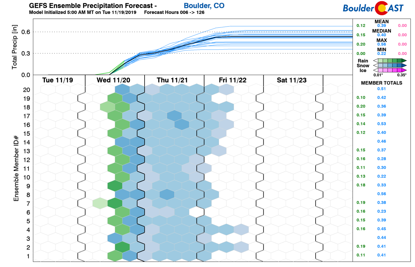
Latest GEFS precipitation forecast for Boulder. ~0.5″ of liquid by Friday…mostly wet snow
- In-between the upper-level forcing late Wednesday night and early Thursday, warmer and drier air is expected to infiltrate the area aloft. This will place a strong capping inversion over-top of a relatively “warm” saturated layer hugging the ground over Boulder and Denver. Based on model soundings (below), there is a good chance that snow will turn over to freezing drizzle in the Metro area overnight. The most likely window for this is from Wednesday at 10:00 PM through Thursday at 8:00 AM. Icing potential is highest in the lower Foothills spreading out eastward a few miles across the Plains where shallow upslope will fuel the drizzle overnight. Areas near and east of Interstate 25 may see dry weather overnight. In any case, light snow should pick back up again Thursday during the day.
.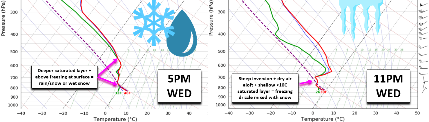
Forecast soundings from the 3km-NAM Wednesday evening (left) and night (right) in Boulder. Rain/snow could transition to freezing drizzle
Here’s our latest forecast timeline:
- Wednesday: Mild in the morning (50’s), but a late-morning cold front will drop temperatures quickly into the 40’s and 30’s by afternoon. After the front, possibly several hours later, rain showers spread across the area and turn to snow by late afternoon or early evening. Snow could be heavy at times, possibly impacting the evening commute with wet slushy accumulation on the roadways in spots. A dusting up to 3″ of snow is possible before midnight.
- Wednesday night: A slight break in the action will occur. Lingering low-level upslope will keep things going in and near the base of the Foothills. Model soundings are indicating a change-over to freezing drizzle, though light snow and flurries will be possible as well. Some eastern areas of Denver could dry out entirely. Be careful traveling overnight and early Thursday due to the icing potential.
- Thursday: Intermittent light snow will continue through the day, especially west and south of Denver. There could be embedded pockets of moderate snow, but it should be short-lived. Highs in the upper 20’s to lower 30’s.
- Thursday night: Periodic light snow continues and simmers down after midnight. Additional accumulation Thursday and Thursday night of a dusting up to 2″.
- Friday: There could be a few morning flurries/snow showers, but most areas will start out just cold and overcast. Skies clear quickly giving way to sun by mid-day or early afternoon with highs staying cold in the middle 30’s to lower 40’s.
Preliminary snow amounts:
- Boulder area: 2-5″
- Denver Metro area: Dusting to 4″, highest west and lowest east
- Foothills: 3-7″
- Mountains above 11,000 feet: 4-9″
For those of you that just do better with charts and maps, here you go!
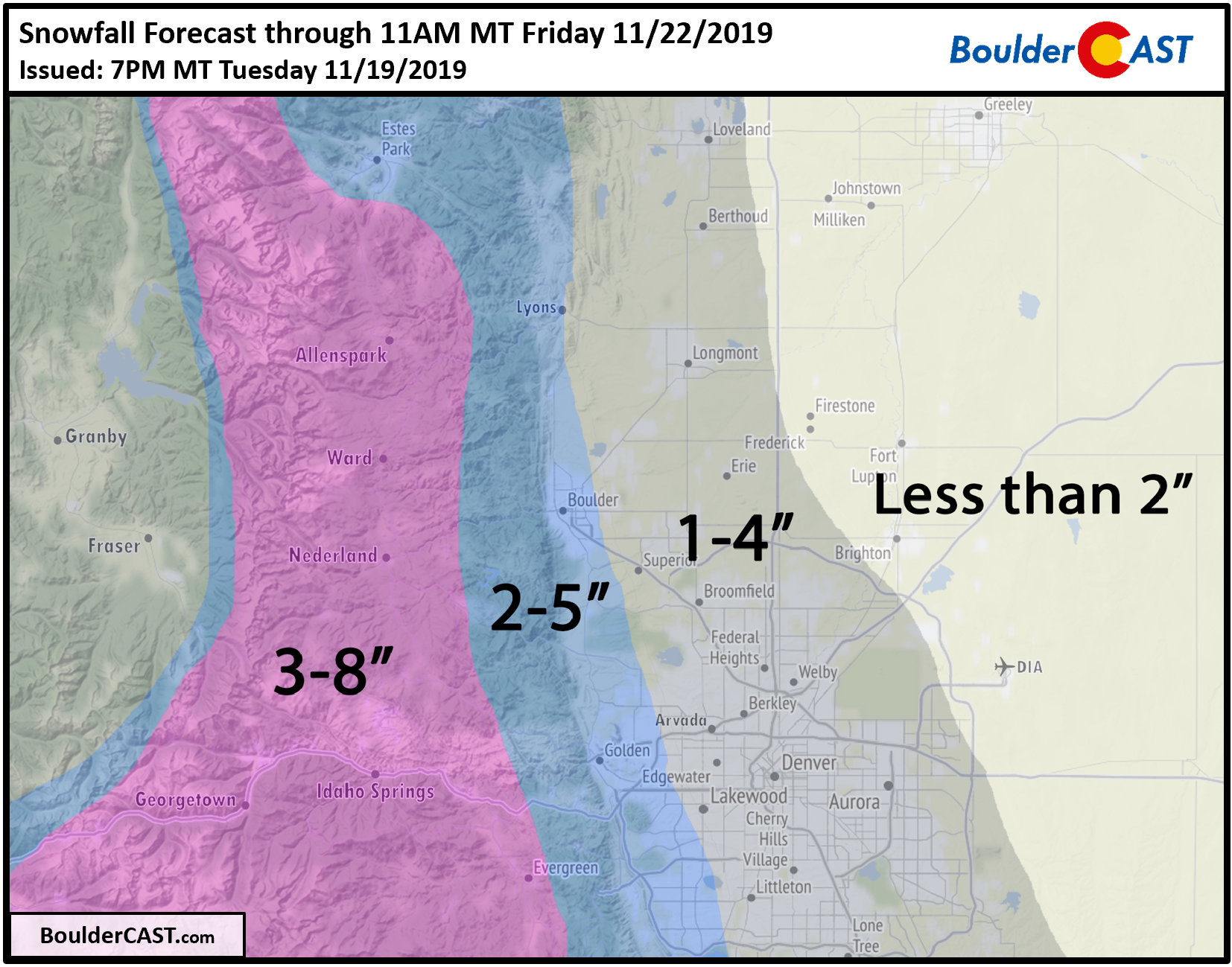
Remember, these forecast amounts cover snow falling from Wednesday early evening into Friday morning – two different waves of snow. There will be considerable melting with accumulation mainly confined to grassy surfaces. The overall low snowfall rates will lead to generally good travel conditions throughout. The Foothills and Mountains could experience minor impacts Wednesday evening into Friday morning.
Please do make the best of the snow. The weather has been a little too nice lately anyways…
We discuss Boulder and Denver weather every single day on BoulderCAST Premium. Sign up today to get access to our daily forecast discussions every morning, complete six-day skiing and hiking forecasts powered by machine learning, access to all our Front Range specific weather models, additional storm updates and much more!
.
Spread the word, share Colorado weather:


You must be logged in to post a comment.