


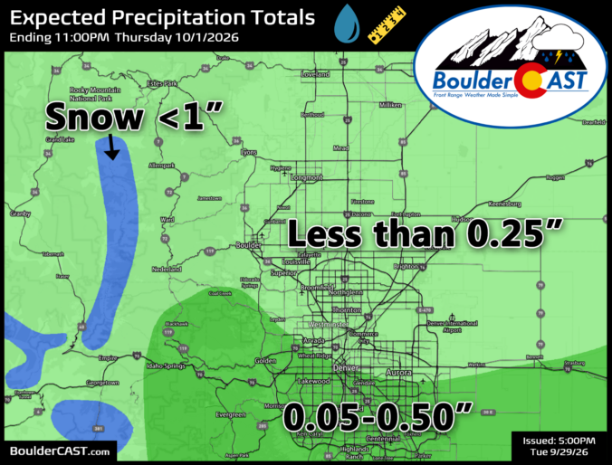
A slow‑moving, high‑stakes storm has been creeping toward Colorado all week — a rare mash‑up of an autumn upper‑low and the juicy tropical remnants of Hurricane Polo — and for a moment, it looked like Boulder and Denver might finally score a true soaking. But as the atmosphere loves to do, the script flipped late. Today’s update breaks down how this once‑promising setup unraveled over the last couple days, why southern Colorado is now squarely in the bullseye, and what scraps of moisture the Front Range can still squeeze out as the system passes by to our south.
This content is for BoulderCAST Premium members only. Join Premium now to get access to our detailed forecast discussions for Boulder and Denver every single day, plus a bunch of other cool perks!

Go Premium, get all the perks.
Daily Forecast Updates
Get our daily forecast discussion every morning delivered to your inbox.
All Our Model Data
Access to all our Colorado-centric high-resolution weather model graphics. Seriously — every one!
Ski & Hiking Forecasts
6-day forecasts for all the Colorado ski resorts, plus more than 120 hiking trails, including every 14er.
Smoke Forecasts
Wildfire smoke concentration predictions up to 84 hours into the future.
Exclusive Content
Weekend outlooks every Thursday, bonus storm updates, historical data and much more!
No Advertisements
Enjoy ad-free viewing on the entire site.











Maybe on a slower weather day you can include a short layman’s explainer of the European vs US forecasting dynamic. And meaning of “ensemble” in meteorology.
Greatly appreciate the newsletter!
Thanks for the idea. Sometimes we do add those nuggets of info in separate posts or just tacked onto the end of the daily updates. Will consider increasing the frequency of those. Cheers.