


A slow‑moving Pacific storm settling in across the West will set the stage for a classic late‑May stretch along the Front Range — warm afternoons, building clouds, and hit‑or‑miss late day showers and thunderstorms. While no day looks like a washout, the pattern does get more interesting mid‑week as deeper moisture sneaks in and storm chances tick upward. We break down what to expect, which day carries the best shot at rain, and how temperatures will swing as the broader system drifts our way.
This week’s highlights include:
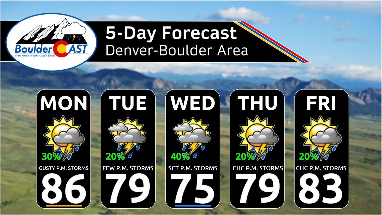
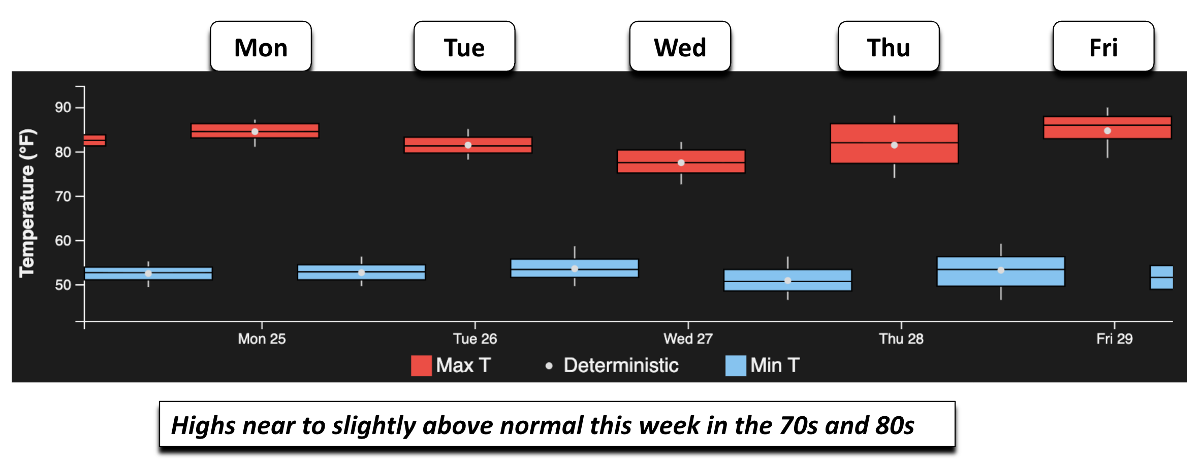
🌡️ Mild, seasonable week with highs mainly in the mid-70s to mid‑80s; coolest on Wednesday, warmest Monday & Friday.
🌦️ Daily isolated to scattered storms, driven by mesoscale boundaries and weak disturbances rotating around a slow‑moving closed low in the Great Basin.
⚠️ Wednesday stands out with the best rain chances as deeper moisture and instability surge northward; low‑end severe can’t be ruled out across portions of eastern Colorado.
😊 No washout days — convection remains hit‑or‑miss each afternoon and early evening.
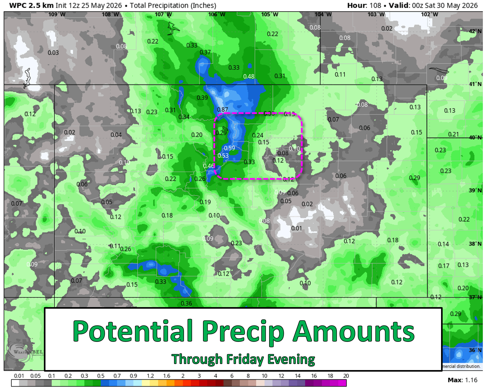
💦 Highly variable rainfall amounts, from under 0.25″ in the Urban Corridor to upwards of one inch in the High Country.
DISCLAIMER: This weekly outlook forecast is created Monday morning and covers the entire upcoming week. Accuracy will decrease as the week progresses as this post is NOT updated. To receive daily updated forecasts from our team, among many other perks, subscribe to BoulderCAST Premium.

Go Premium, get all the perks.
Daily Forecast Updates
Get our daily forecast discussion every morning delivered to your inbox.
All Our Model Data
Access to all our Colorado-centric high-resolution weather model graphics. Seriously — every one!
Ski & Hiking Forecasts
6-day forecasts for all the Colorado ski resorts, plus more than 120 hiking trails, including every 14er.
Smoke Forecasts
Wildfire smoke concentration predictions up to 72 hours into the future.
Exclusive Content
Weekend outlooks every Thursday, bonus storm updates, historical data and much more!
No Advertisements
Enjoy ad-free viewing on the entire site.
A mild week with daily isolated showers and storms
Our weather week ahead will focus on a large closed low that dives down from the Pacific Northwest and reaches Nevada and California by the middle of the week. The system slowly progresses eastward as we head into the tail end of the week and weekend. The ECMWF AIFS depiction below captures the sluggish evolution well.
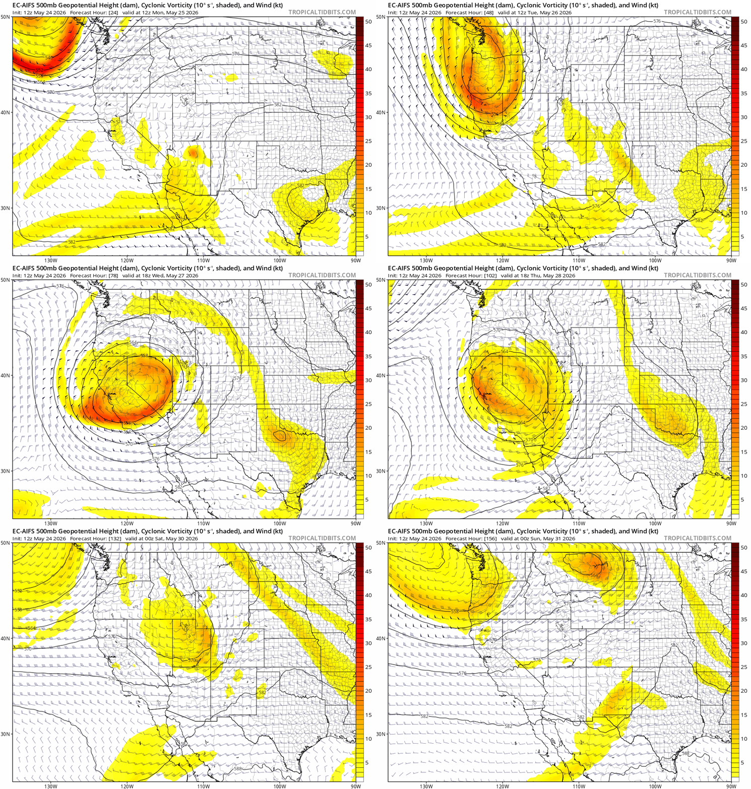
The important takeaway: this is not a widespread, all‑day rain setup for the Front Range. Instead, the closed low will act as a background influencer—enhancing moisture transport, steepening lapse rates at times, and sending subtle vorticity lobes overhead. That combination will favor isolated to scattered afternoon convection, but with large spatial variability and no single day that looks like a washout.
Daily storm chances driven by mesoscale boundaries
The GEFS and other ensemble systems continue to show a familiar warm‑season signal: weak but persistent afternoon CAPE, modest mid‑level flow, and no dominant forcing mechanism. That means storms will be hit‑or‑miss, forming along:
- mesoscale boundaries such as outflows from earlier storms
- terrain‑induced circulations along the Foothills (i.e. the Denver Cyclone boundary)
- subtle vorticity lobes rotating around the broader closed low
This is the type of pattern where one neighborhood could get a 20‑minute downpour while another stays bone‑dry, not unlike our summer monsoon pattern.
Wednesday: the most interesting day
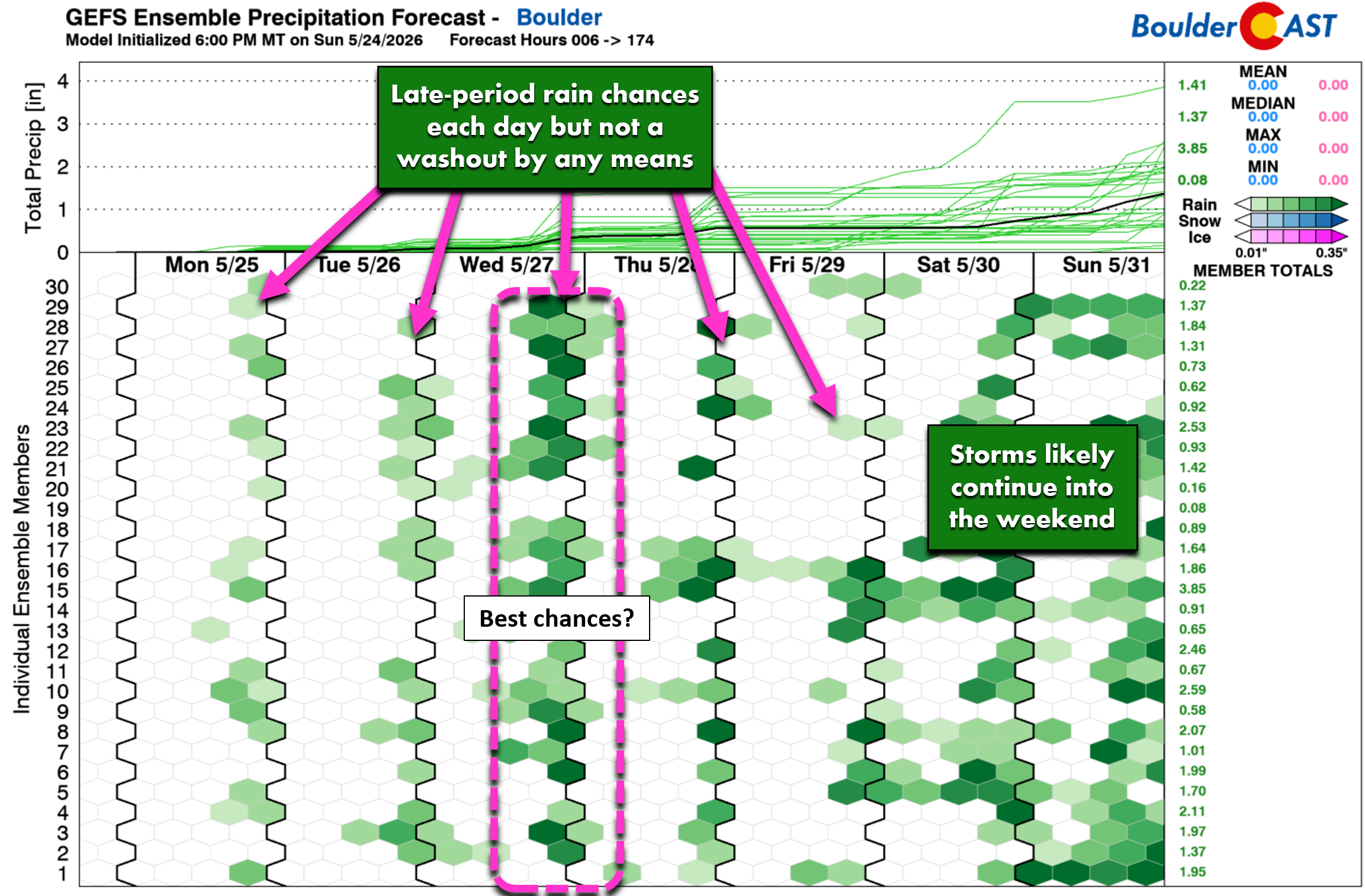
If there’s a day to watch more closely, it’s Wednesday. By then, the closed low drifts towards Utah, and Colorado sits beneath a deepening moisture plume sourced from both the Gulf of Mexico and the subtropical eastern Pacific. Precipitable water values rise to 120–150% of normal, and instability increases as cooler mid‑level temperatures overspread the region.

Even though SPC has not highlighted the area for severe weather, we cannot dismiss the potential for low‑end severe storms. Expect:
- CAPE in the 500–1500 J/kg range
- Marginal shear (20–30 kt)
- The best chance of strong or a few severe storms east of Denver towards Kansas.
Cloud cover and increased moisture may also make Wednesday the coolest day of the week, with highs struggling to reach the lower 80s.
Temperatures: staying above normal
Highs this week generally hover in the mid-70s to mid‑80s, which is on the warmer side for late‑May climatology which pegs our highs in the middle 70s. The NBM box‑and‑whisker plot below shows modest ensemble uncertainty, with the coolest guidance clustered around Wednesday and the warmest around Monday and Friday.
- Coolest day: Wednesday (lots of clouds + best chance of rain + weak high pressure nosing in from the Northern Plains)
- Warmest day (not including Monday): Friday (reduced storm coverage + warming airmass ahead of the low’s eastward drift)
Rainfall amounts: highly variable, boundary‑dependent
This will be a classic “your mileage may vary” week. With storms firing on small‑scale features, rainfall totals will depend entirely on where individual cells track.
Expected totals through Friday:
- Denver-Boulder area: a few hundredths to 0.25″
- Foothills & High Country: 0.25″ to 0.75″
- Isolated pockets: locally higher where slow‑moving or repeat cells develop
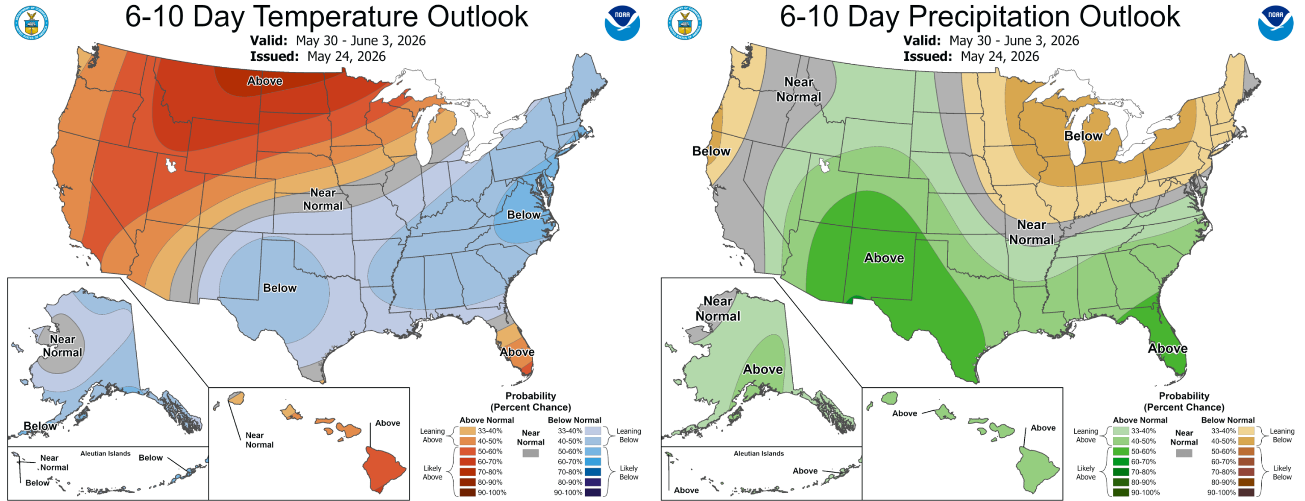
Fairly warm and unsettled weather is likely to continue through the upcoming weekend into next week with daily chances for showers and storms, though here in the Front Range we’ll continue to struggle with a similar lack of large-scale forcing, instead relying on small-scale boundaries and the diurnal cycle of instability from solar heating.
Bottom Line
All in all, it won’t be a bad week across the Front Range with warm temperatures, but keep an eye out each and every day during the afternoon and evening for developing spotty showers and thunderstorms.
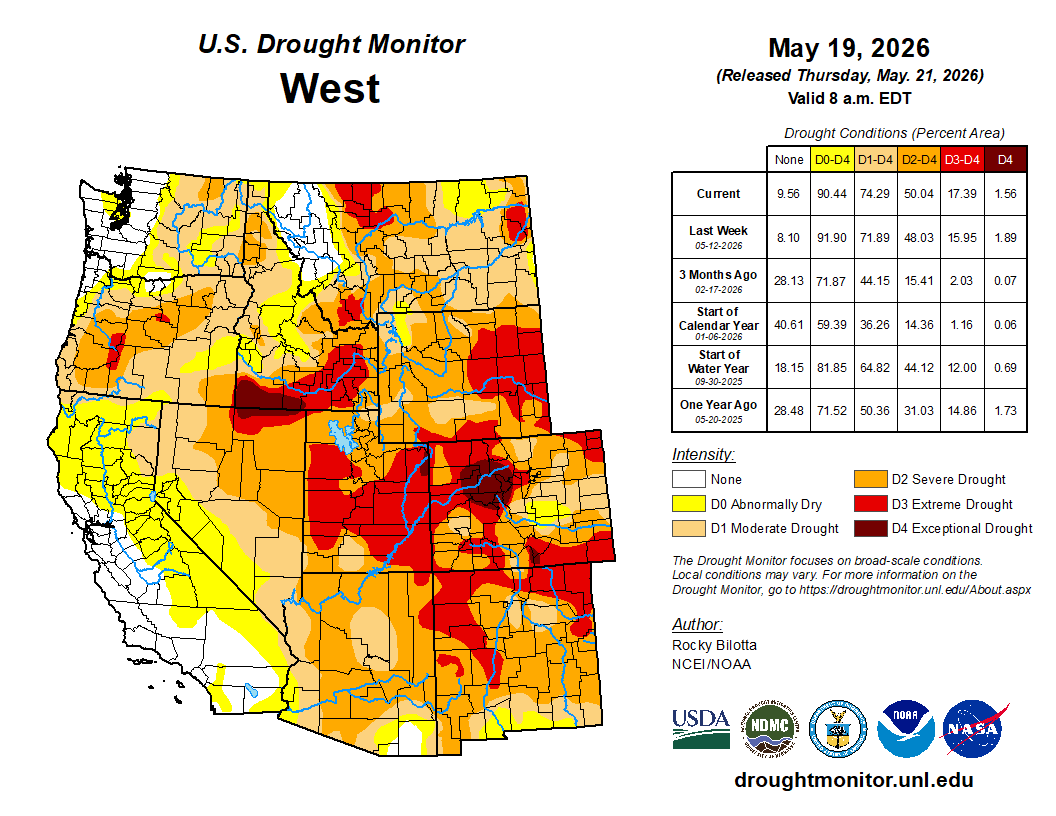
From a drought perspective, this isn’t a pattern that will deliver broad, meaningful relief. Though we have seen meaningful drought improvement in the last few weeks thanks to a pair of soaking storms, all of Colorado remains in a long‑running moisture deficit, and the scattered, boundary‑driven storms expected this week tend to favor localized pockets of rain rather than widespread soaking. That said, any showers we do pick up will offer some short‑term benefits — briefly easing fire danger, adding a little surface moisture, and helping keep temperatures in check — even if they don’t substantially shift the larger hydrologic picture.
Happy Memorial Day from the BoulderCAST Team. Enjoy the week!

Forecast Specifics:
Monday: Morning sun turning partly cloudy. Highs in the middle 80s on the Plains and near 70 in the Foothills with afternoon and evening widely scattered gusty storms. Minimal rainfall, but up to 40 MPH wind gusts. The chance is about 20-30 percent.
Tuesday: Mostly cloudy with a few isolated to widely scattered storms in the afternoon/evening. Highs in the upper 70s on the Plains with middle 60s in the Foothills.
Wednesday: Increasing clouds with scattered afternoon and evening storms. The chance is about 40 percent. Highs in the middle 70s on the Plains and lower 60s in the Foothills.
Thursday and Friday: Highs warmer in the low to middle 80s for the Plains and upper 60s in the Foothills. Afternoon and evening isolated or widely scattered storms will again be possible, with that potential at about 20 percent each day, though these days are more uncertain in the extended.
DISCLAIMER: This weekly outlook forecast is created Monday morning and covers the entire upcoming week. Accuracy will decrease as the week progresses as this post is NOT updated. To receive daily updated forecasts from our team, among many other perks, subscribe to BoulderCAST Premium.
Go Premium, get all the perks.
Daily Forecast Updates
Get our daily forecast discussion every morning delivered to your inbox.
All Our Model Data
Access to all our Colorado-centric high-resolution weather model graphics. Seriously — every one!
Ski & Hiking Forecasts
6-day forecasts for all the Colorado ski resorts, plus more than 120 hiking trails, including every 14er.
Smoke Forecasts
Wildfire smoke concentration predictions up to 72 hours into the future.
Exclusive Content
Weekend outlooks every Thursday, bonus storm updates, historical data and much more!
No Advertisements
Enjoy ad-free viewing on the entire site.
Enjoy our content? Give it a share!












Hay Andy, I just transplanted my tomatoes and they being tropicals I am very much concerned with the lows, (even more than the highs). Any chance they could be included in your forecast?
—
In Agape
George
Hey George, thanks for reaching out. We don’t generally include overnight lows in our forecast, but may consider it in the future as we get that request fairly often. That said, this week’s lows are pretty much sticking to the 54 to 58° range (mild for this time of year).