

After weeks of unseasonable warmth and bone‑dry skies, the Front Range is finally staring down a pattern shift this week. But will it deliver the moisture we’ve been waiting for—or just more wind and disappointment? In this update, we break down some stats from our parched autumn so far, and take a look at several storm systems moving through Colorado this week, one of which will offer an excellent chance of rain (and maybe some snow) in the Boulder-Denver area.
This week’s highlights include:
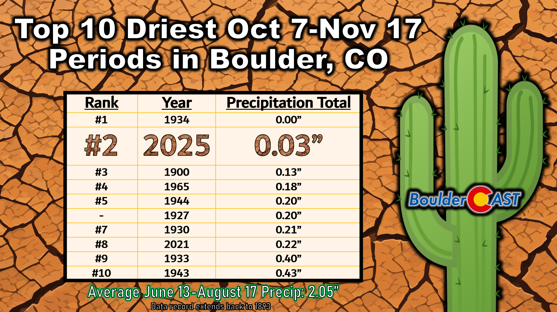
- Exceptionally Warm & Dry This Fall: The Front Range has gone six weeks without meaningful precipitation, making Oct 7–Nov 17 2025 the second‑driest on record for Boulder, even drier than the lead‑up to the 2021 Marshall Fire.
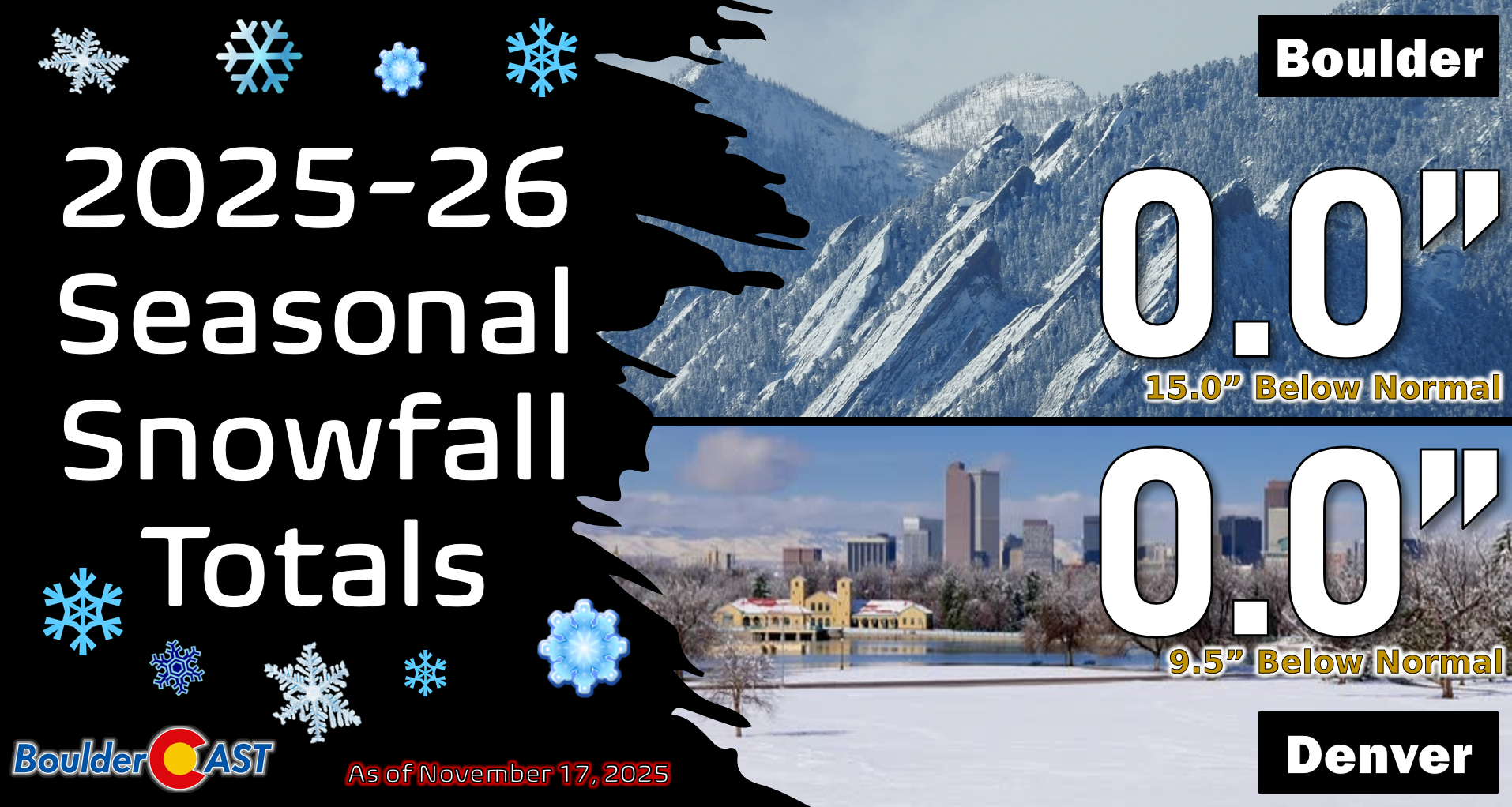
- Snowfall Deficit: The lower elevations haven’t seen a single snowflake yet, breaking the latest first‑snow record in Boulder (Nov 17+, most reliable data) and nearing the older, less reliable 1910 record of Nov 26.
- Warmth Records: Boulder hit 70°+ on half the days in November, setting three daily records and a new all‑time November high of 81° on Nov 3. This has been the third warmest start to November.
- Pattern Shift Ahead: The ridge that fueled record warmth has broken down, with a storm track shifting south and multiple systems lining up to impact Colorado through Thanksgiving.
- First Storm on Monday Misses: A low over Wyoming has ushered in cooler temps and strong downslope winds but little precipitation for the Front Range as it tracked too far north; light snow continues in the Mountains.
- Late-Week Storm is More Favorable: Another low pressure late in the week will offer the best chance of moisture in a long time here
- Still lots of uncertainty regarding storm track and intensity, but upwards of 0.5″ of moisture is possible across our area
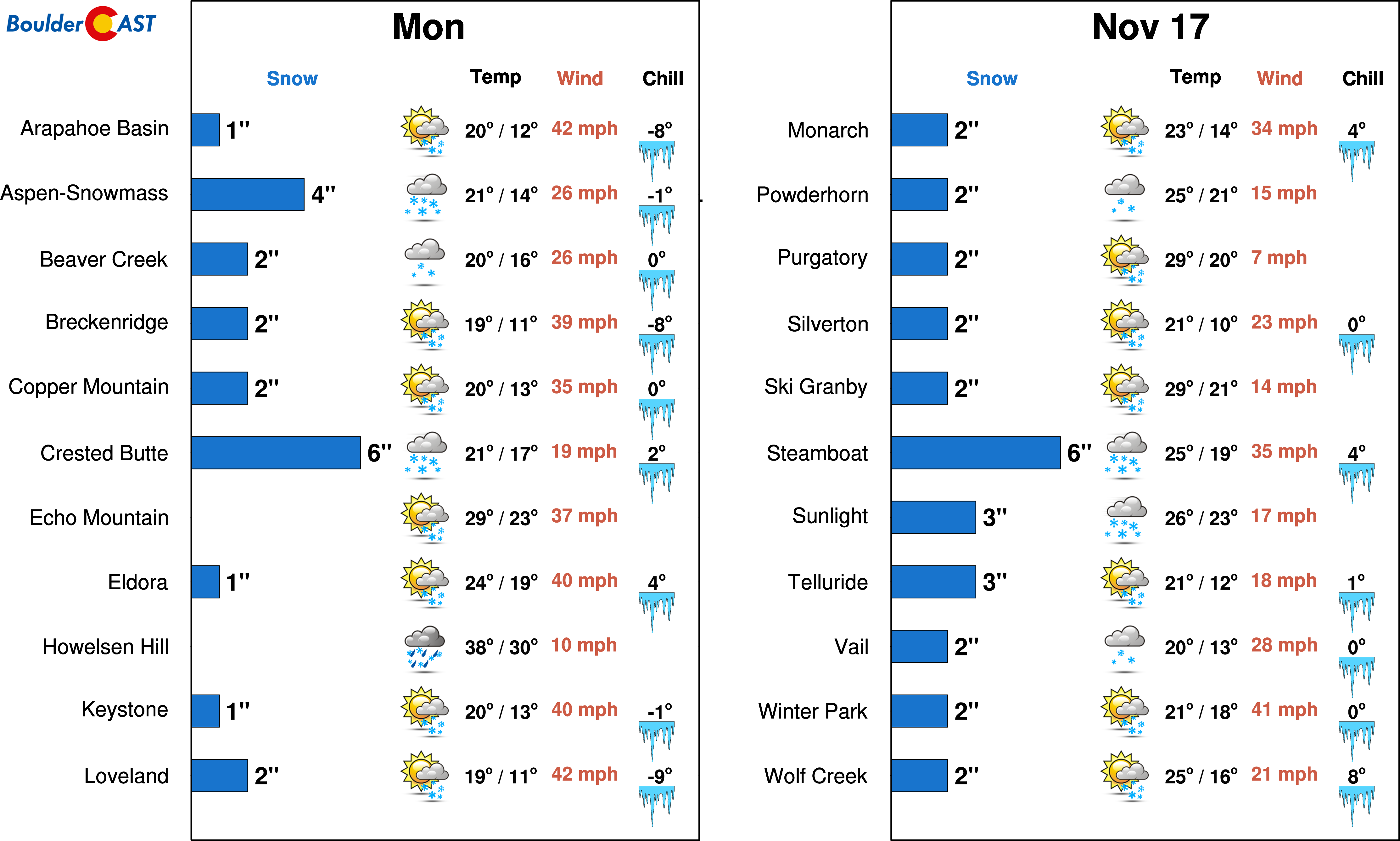
- Warm temperatures will mean mostly rain for the lower elevations, with snow in the Foothills and Palmer Divide. Some light snow may mix in across the Boulder-Denver area.
DISCLAIMER: This weekly outlook forecast is created Monday morning and covers the entire upcoming week. Accuracy will decrease as the week progresses as this post is NOT updated. To receive daily updated forecasts from our team, among many other perks, subscribe to BoulderCAST Premium.

Go Premium, get all the perks.
Daily Forecast Updates
Get our daily forecast discussion every morning delivered to your inbox.
All Our Model Data
Access to all our Colorado-centric high-resolution weather model graphics. Seriously — every one!
Ski & Hiking Forecasts
6-day forecasts for all the Colorado ski resorts, plus more than 120 hiking trails, including every 14er.
Smoke Forecasts
Wildfire smoke concentration predictions up to 72 hours into the future.
Exclusive Content
Weekend outlooks every Thursday, bonus storm updates, historical data and much more!
No Advertisements
Enjoy ad-free viewing on the entire site.
Snowless so far as our warm & dry autumn continues
It’s been an exceptionally dry fall along the Front Range. In fact, Boulder has gone six weeks without any meaningful precipitation—just a few sprinkles here and there. That puts 2025 in second place for the driest such stretch on record (October 7 to November 17), even drier than the same stretch in 2021 leading up to the Marshall Fire.
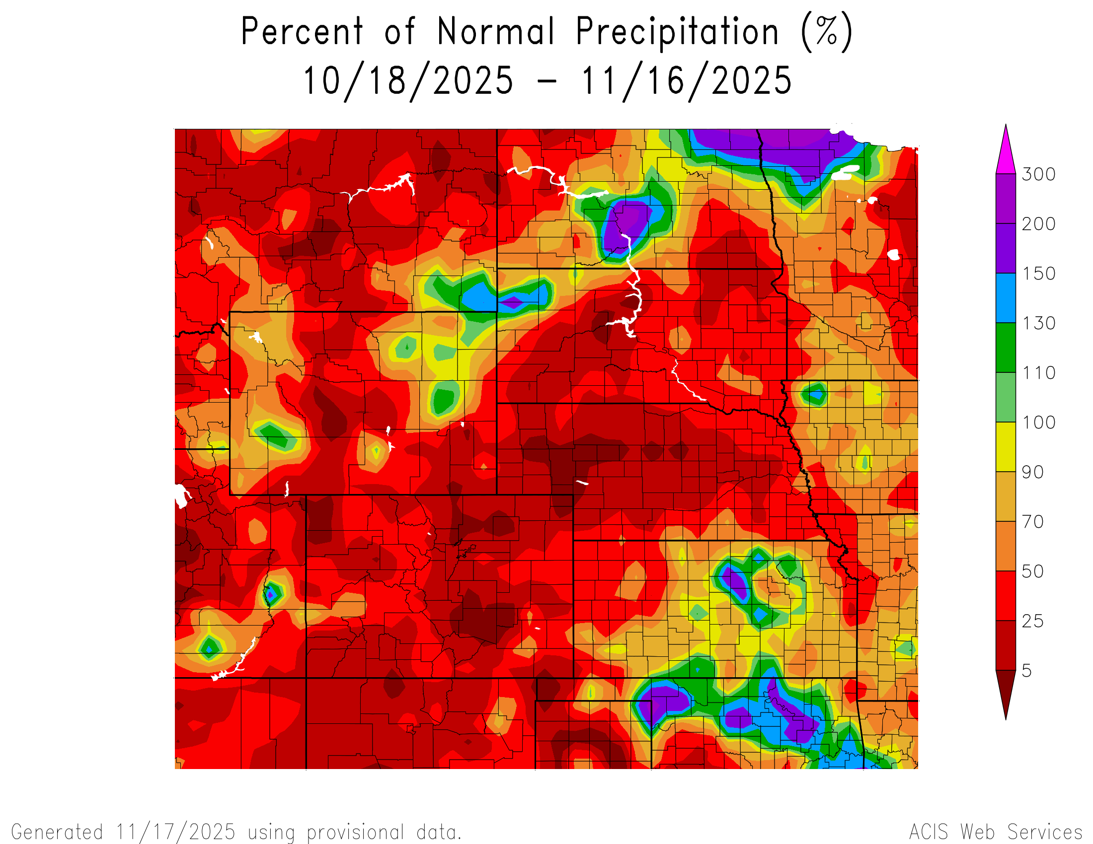
Across most of Colorado, precipitation has been scarce. The Mountains have managed a few light snow events, but nothing close to what we’d normally expect by mid-November.
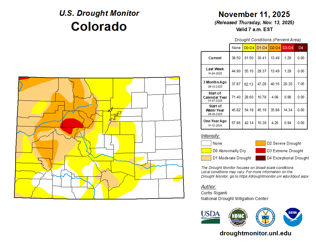
The U.S. Drought Monitor has now bumped our area into the “Abnormally Dry” category, with Moderate Drought creeping into southern Denver. Despite a wet end to summer, more severe drought continues to hang on in the High Country, especially along the I‑70 Corridor.
The lower elevations have yet to see a single snowflake this season, with Boulder now guaranteed to break its latest first snow record of November 17th based on reliable data dating back to 1948. We’ve gotten a few questions about this, and the historical record does deserve some elaboration here. Prior to 1948, data was more sparse for the city of Boulder, especially for snow, so typically we don’t like to reference snowfall data prior to 1948 for this reason. However, the potentially incomplete data back then did have a later first snow noted in 1910 on November 26th. Whether that is totally accurate is unknown, but either way, we’re now within striking distance of surpassing even that date as well.
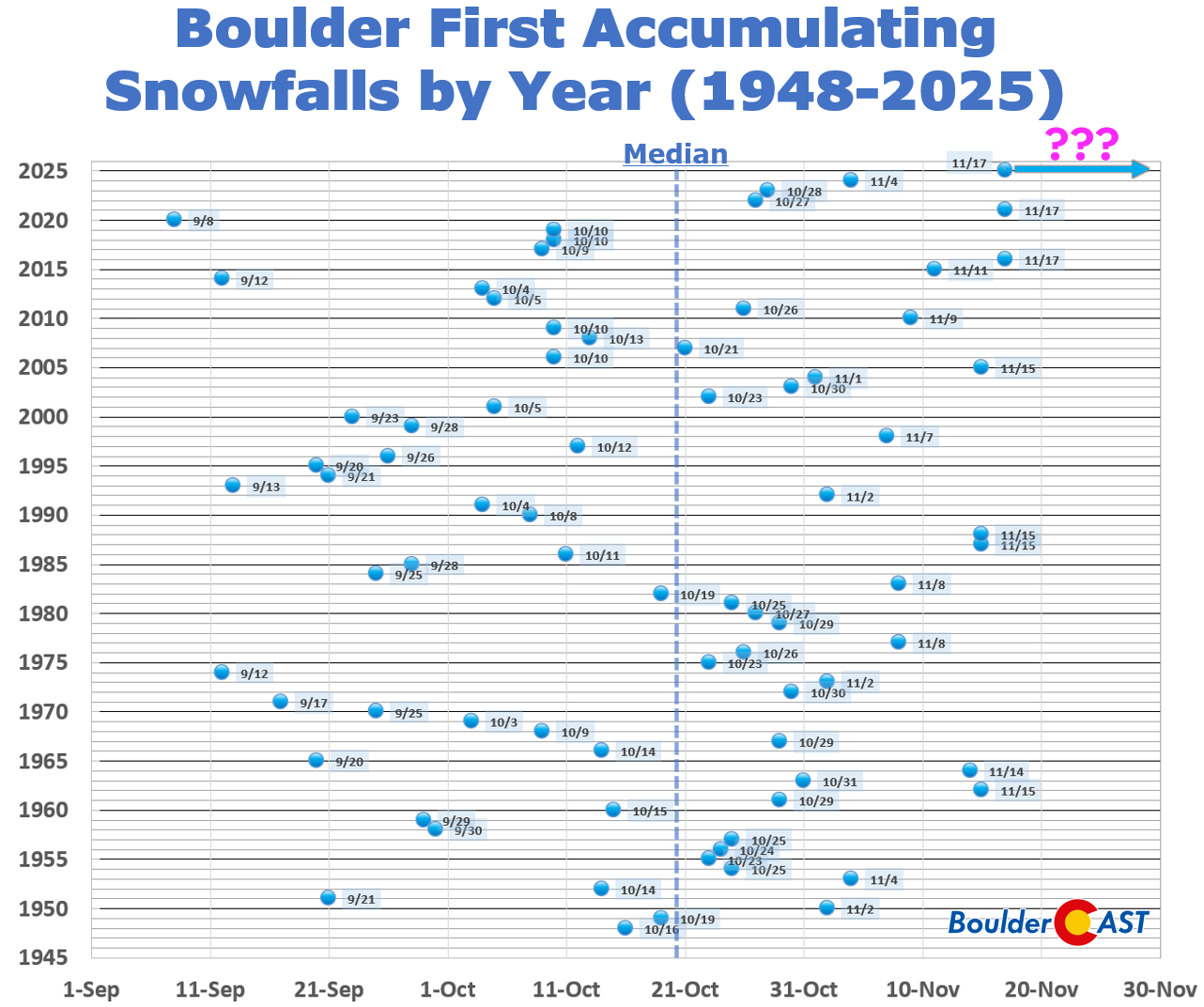
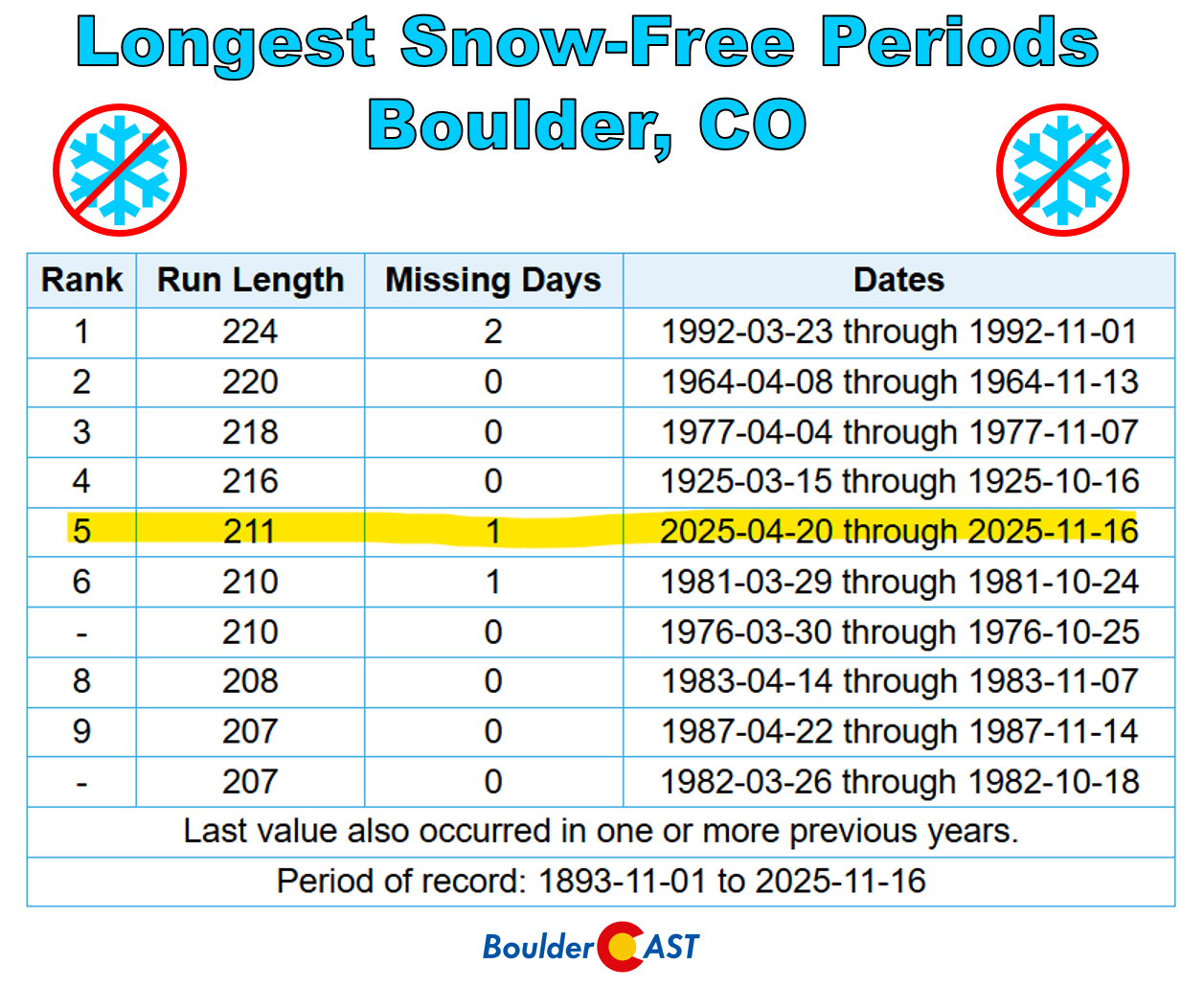
Boulder’s snow-free streak has now ballooned to 211 days, good enough for 5th all-time. We will likely reach at least 215 days with no snow in the forecast the next few days (spoiler alert!).
We’ve definitely dug ourselves quite the snowfall deficit early in the season, but at least there is still plenty of time to catch up.
Exceptionally warm temperatures have only added to the unusual fall feel. Boulder has hit 70° or warmer on half the days so far in November, including three new daily record highs (November 3rd, 13th, and 14th). On November 3rd, we even set a new all‑time November record at 81°F.
This has been the third warmest start to November since 1893 with an average high temperature of about 69° so far this month. Needless to say, recently our weather has felt like anything but fall…
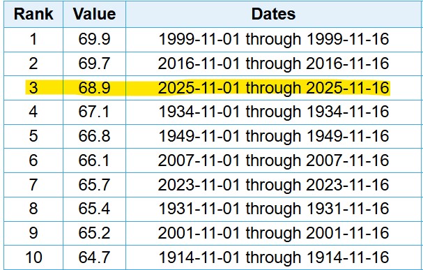
Top 10 Warmest first 16 days of November in Boulder history (Mean High Temperature)
Pattern Shift: Cooler, Stormier Days Ahead?
As of Monday morning, the well‑advertised pattern change is underway. The amplified ridge that gave us record warmth has broken down, and the storm track is shifting south. Several systems are lining up to move across the western United States, bringing somewhat cooler and more unsettled weather to Colorado through Thanksgiving.
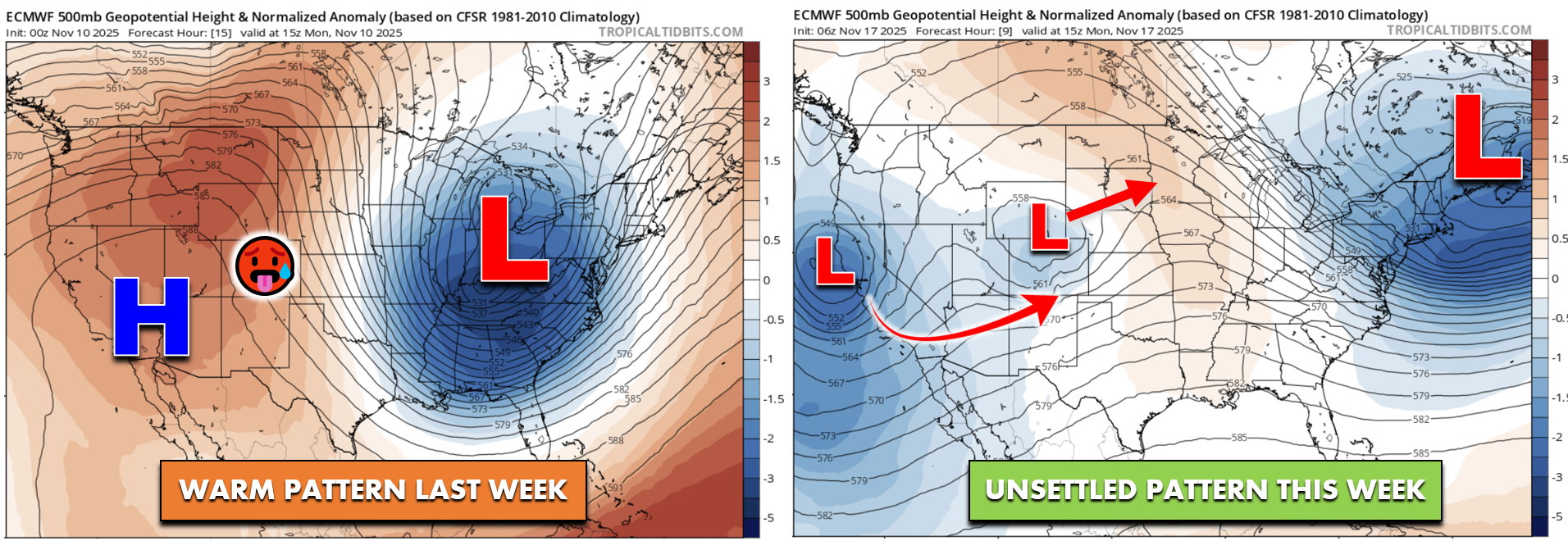
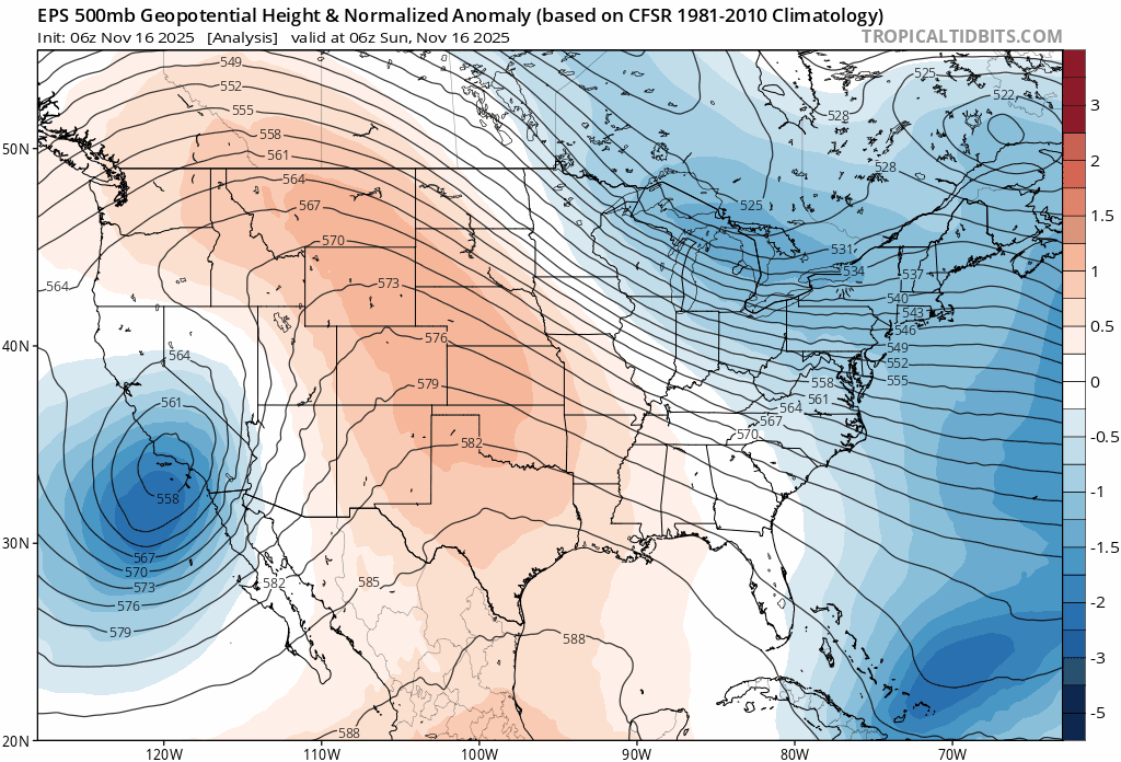
The European ensemble 500mb height forecast animation below highlights a “wave train” of three storms moving in sequence. Each drops into southern California, stalls briefly, then gets swept east across the Four Corners. The first storm is already impacting Wyoming today, the second is expected to reach southeast Colorado later this week, and the third should pass by south of us early next week with little fanfare. Storm #2 coming late this week is the one to watch for impacts in the Front Range.
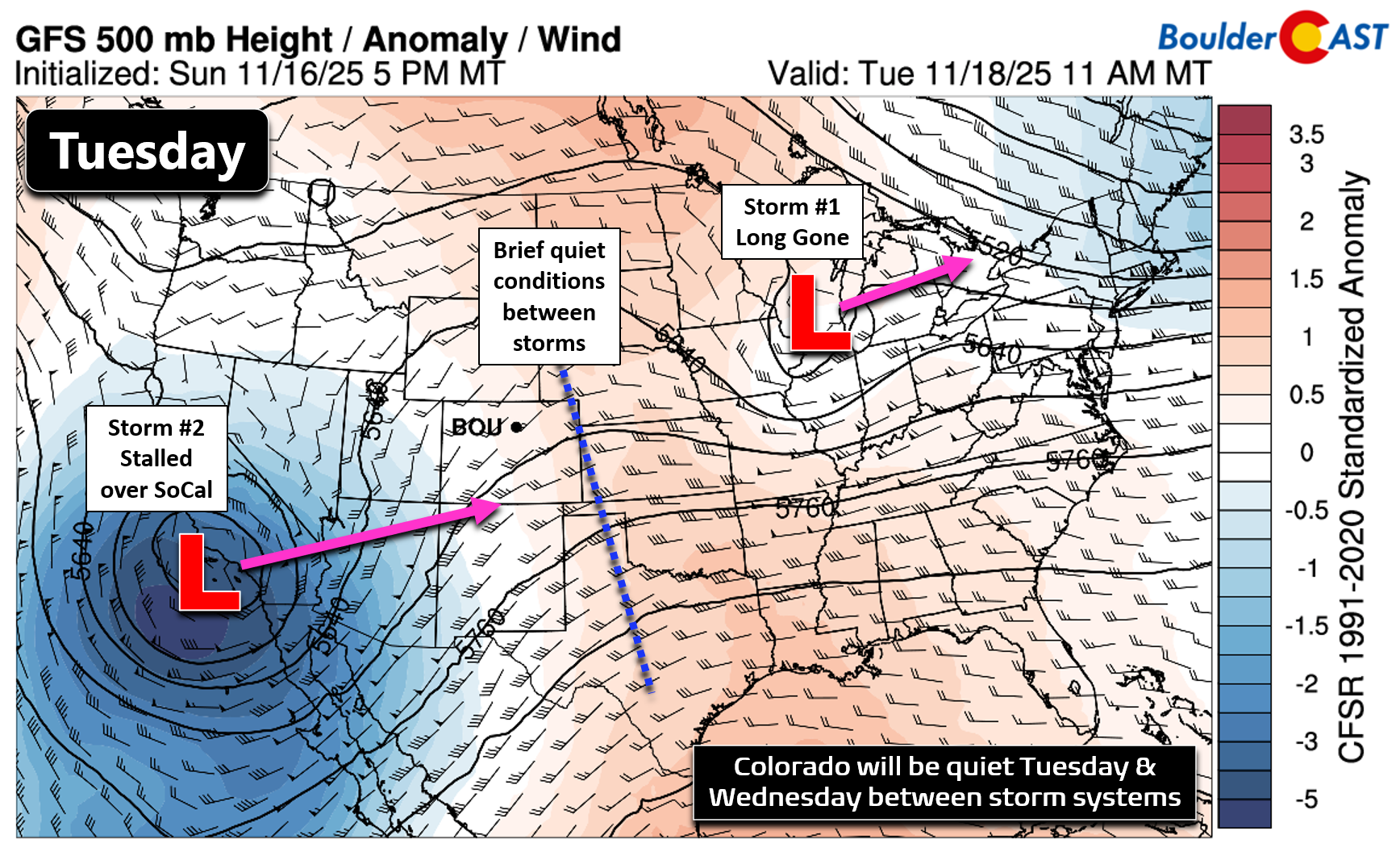
Storm #1: Mostly Wind, Little Moisture
Let’s take a closer look at the first storm which is already impacting the state Monday morning in the form of a closed low pressure system in southwestern Wyoming. As mentioned, this low came to via southern California, but unfortunately took a track a bit too far northwest, with the Front Range ending up in the dry slot and downslope regime on its southern flank.
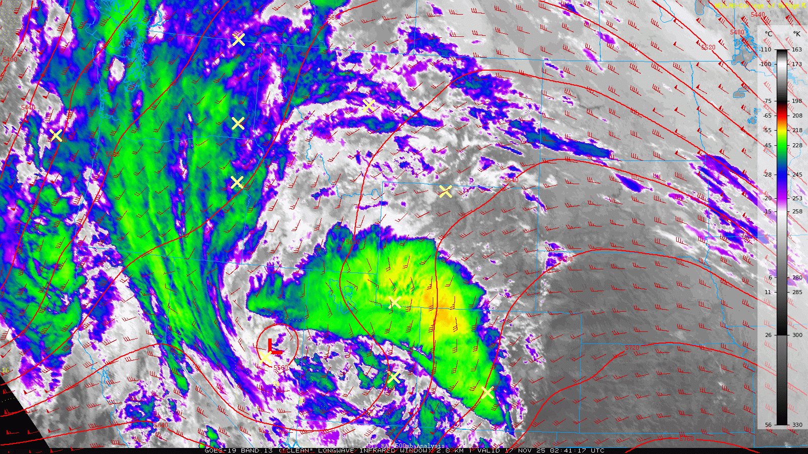
There was a brief wave of precipitation generated across portions of the area late Sunday evening, but these (rain) showers didn’t hold together well coming off the terrain. Boulder had a couple sprinkles of rain (nothing measurable), but that’s about it. More substantial rain (lower Foothills) and some snow did occur higher up just to our west.

As the low moves east today, wrap‑around westerly flow will favor light to moderate orographic snow in the Mountains, but downslope winds will dominate the Denver Metro area. Expect highs in the upper 50s, about 10-15° cooler than Sunday, with gusty winds: 20–30 MPH in Denver, 35–50 MPH in Boulder and the Foothills.
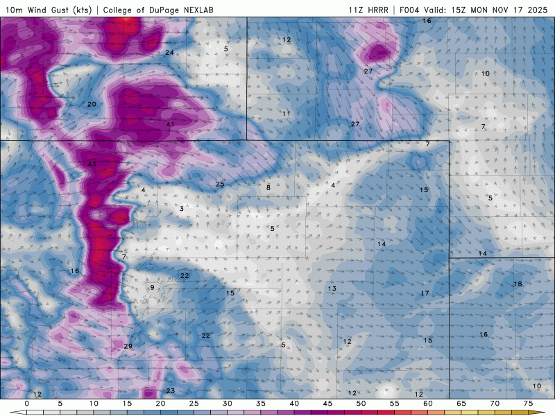
HRRR wind gust forecast for Monday. Blustery conditions will be around, especially in/near the Foothills
Storm #2: Our Best Shot at Moisture
Tuesday and Wednesday will be relatively quiet across the area between storm systems as a weak ridge develops over eastern Colorado. Storm #1 from Monday will be long gone into the Great Lakes, while Storm #2 takes shape across southern California during this time. Both days should see highs reach the lower 60s in the Boulder-Denver area.
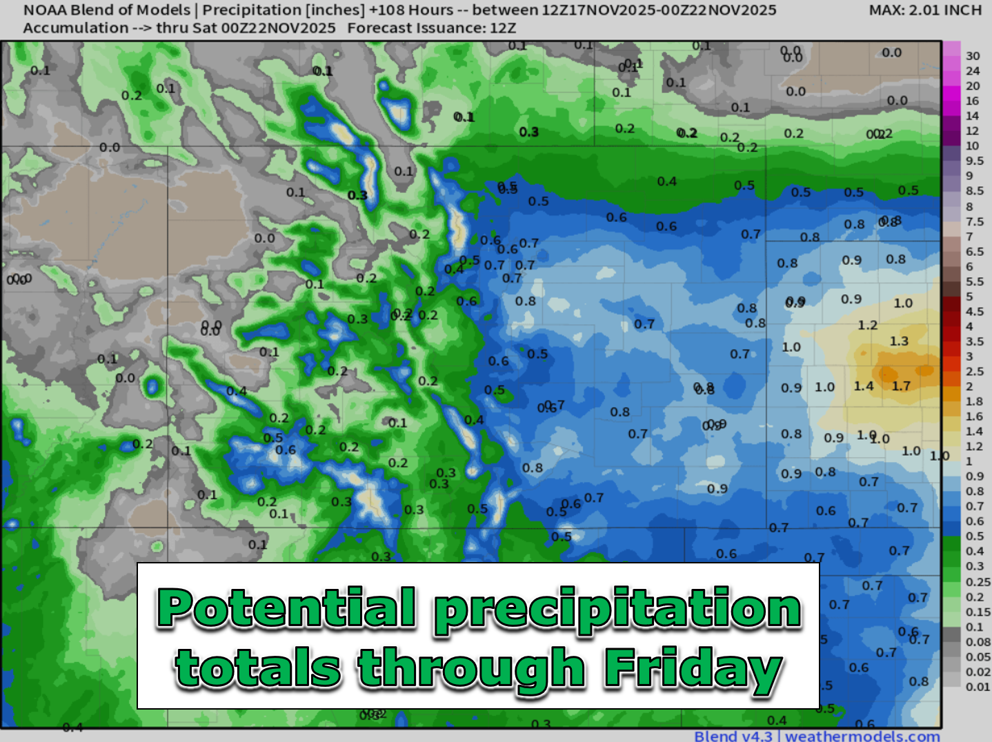
But late in the week, Storm #2 could finally bring us some much‑needed precipitation and cooler temps. Models have been inconsistent in recent days, but are now converging on a track across southeastern Colorado late Thursday into Friday.
- Euro model: Slightly farther north, which favors greater precipitation for the Front Range and a slightly higher chance of some snow mixing in for Boulder/Denver.
- GFS model: Farther south, which would limit impacts here to light rain showers.
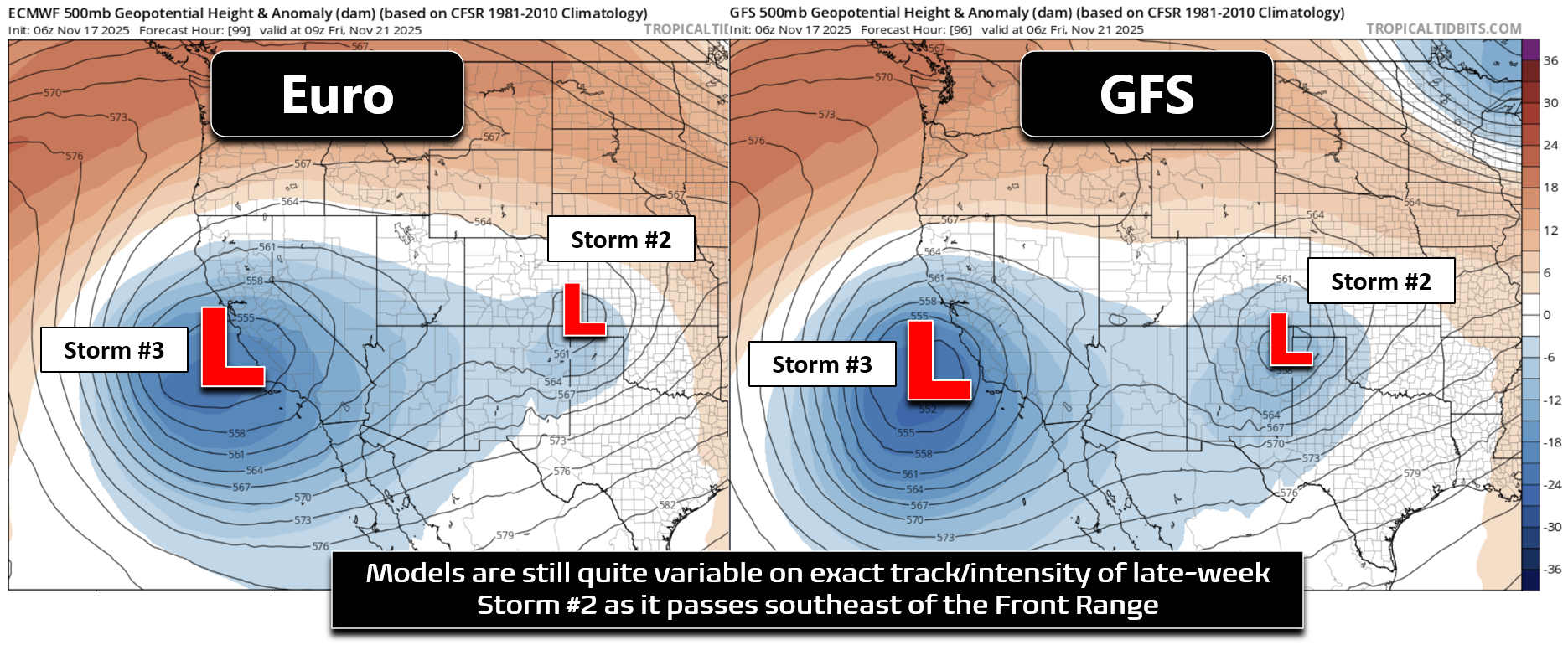
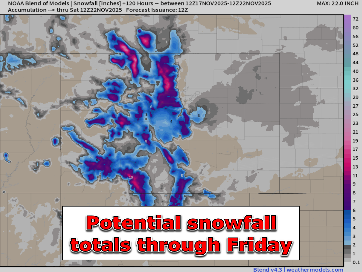
Exactly how this storm tracks across the southern Rockies will determine the eventual impacts here, and at this point four days out, this remains highly uncertain. For some context, as of now, Storm #2 is still offshore from Oregon, while Storm #3 (which will be steering Storm #2) is still way off in the Bering Sea between Alaska and Russia. As it stands though, we expect to see a good chance of precipitation in our neck of the woods late Thursday into Friday. It’s important to note that there won’t be much cold air getting pulled into this storm, unless it really blows up into a more significant low pressure. Thus, it looks like this would be mostly or all rain across the lower elevations regardless of what happens. At least that appears to be the most likely scenario right now. About 90% of GFS ensemble members have precipitation in Boulder later this week, but only ~30% have accumulating snow.
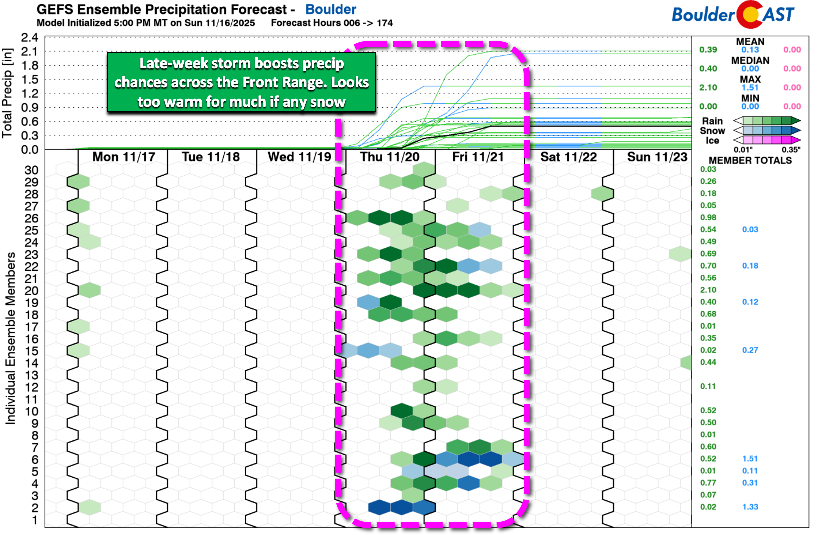
Nonetheless, snow or not, we need any and all moisture we can get given how dry things have been of late. Blended model solutions would suggest upwards of 0.5″ of precipitation is on the way later this week. Keep in mind the Euro model, with its more northern track, is doing much of the heavy lifting here towards those totals.
While our first measurable snow of the season is certainly still in the mix for Storm #2, it doesn’t look overly likely with mostly rain expected across the lower elevations. The Foothills and Palmer Divide stand the best chance to see a little bit of a white stuff later this week.
Storm #2 Bottom Line:
- Timing: Late day Thursday into Friday.
- Setup: Storm develops over southern California midweek, then ejects east across the southern Rockies late-week.
- Track Uncertainty:
- Euro model: Farther north, which would favor greater precipitation for the Front Range.
- GFS model: Farther south, which would limit precipitation here.
- Precipitation Chances:
- ~90% of ensemble members show measurable precipitation
- Only ~20-30% show minor accumulating snow at lower elevations.
- Precipitation Type: Mostly rain expected for Boulder/Denver due to limited cold air, though some minor snow is not out of the question. Snow is more likely in the Foothills and Palmer Divide.
- Precipitation Totals: Blended guidance suggests around 0.5″ of much-needed moisture for our area. There is still a big spread though from nearly nothing to over 1.0″ in the most bullish model runs.
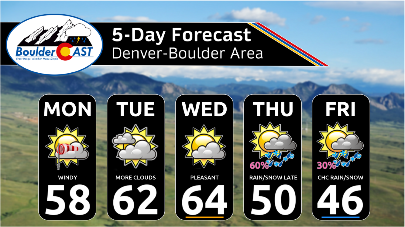
As mentioned at nauseum already, the late-week storm is still uncertain — even more so considering how fickle models have been of late. For now, we’re adding a few snowflakes into the five‑day forecast for the first time this season. How about that?! After weeks of very dry, warm weather, any precipitation—rain or snow—will be a welcome change. Stay tuned for updates through the week as the we refine the track of storm — let’s hope this one delivers something.
Forecast Specifics:
Monday: Partly cloud and windy with gusts of 20 to 30 MPH common, with up to 50 MPH in and near the Foothills. Highs reach the upper 50s on the Plains with upper 40s in the Foothills.
Tuesday: Partly to mostly cloudy and mild with highs in the lower 60s on the Plains and upper 40s in the Foothills.
Wednesday: Partly cloudy, quiet and somewhat warm. Highs reach the low to middle 60s on the Plains with lower 50s in the Foothills.
Thursday: Increasing clouds with rain showers developing in the afternoon or evening, lingering into the overnight. Snow levels generally stay above 6000 feet, but some snow across the Boulder-Denver area Thursday night into Friday is not out of the question. Temperatures cooler near 50 on the Plains with near 40 in the Foothills.
Friday: Rain/snow showers may still be around in the morning to afternoon, eventually drying out late in the day. Highs on the 40s for the Plains with 30s in the Foothills.
Weekend: Likely quiet and seasonal as we’ll once again be between storm systems under weak ridging. Temperatures likely somewhere in the 50s, around or slightly above seasonal norms.
DISCLAIMER: This weekly outlook forecast is created Monday morning and covers the entire upcoming week. Accuracy will decrease as the week progresses as this post is NOT updated. To receive daily updated forecasts from our team, among many other perks, subscribe to BoulderCAST Premium.
Go Premium, get all the perks.
Daily Forecast Updates
Get our daily forecast discussion every morning delivered to your inbox.
All Our Model Data
Access to all our Colorado-centric high-resolution weather model graphics. Seriously — every one!
Ski & Hiking Forecasts
6-day forecasts for all the Colorado ski resorts, plus more than 120 hiking trails, including every 14er.
Smoke Forecasts
Wildfire smoke concentration predictions up to 72 hours into the future.
Exclusive Content
Weekend outlooks every Thursday, bonus storm updates, historical data and much more!
No Advertisements
Enjoy ad-free viewing on the entire site.
Enjoy our content? Give it a share!


You must be logged in to post a comment.