

Front Range Colorado is bracing for a scorching stretch ahead as a powerful heat dome settles in, sending daily highs into the 90s and even near 100°F come Friday. Fire danger is also set to rise with bone-dry downslope winds ramping up in the days ahead. But there’s relief on the horizon: a cold front will finally break the heatwave by Monday, bringing much cooler temps, a shot at rain, and the kind of weather we’ll certainly be ready for!
At a Glance:
- A major heatwave is underway, with a strong high-pressure ridge locking in hot, dry weather across the southwestern U.S.; Colorado is expected to see scorching temperatures through the weekend, with Friday peaking near 100°F.
- Friday and Saturday are forecast to be the hottest, though updated models suggest temperatures will stay just shy of earlier predictions—still, widespread upper 90s are expected, and a Heat Advisory is in effect both days.
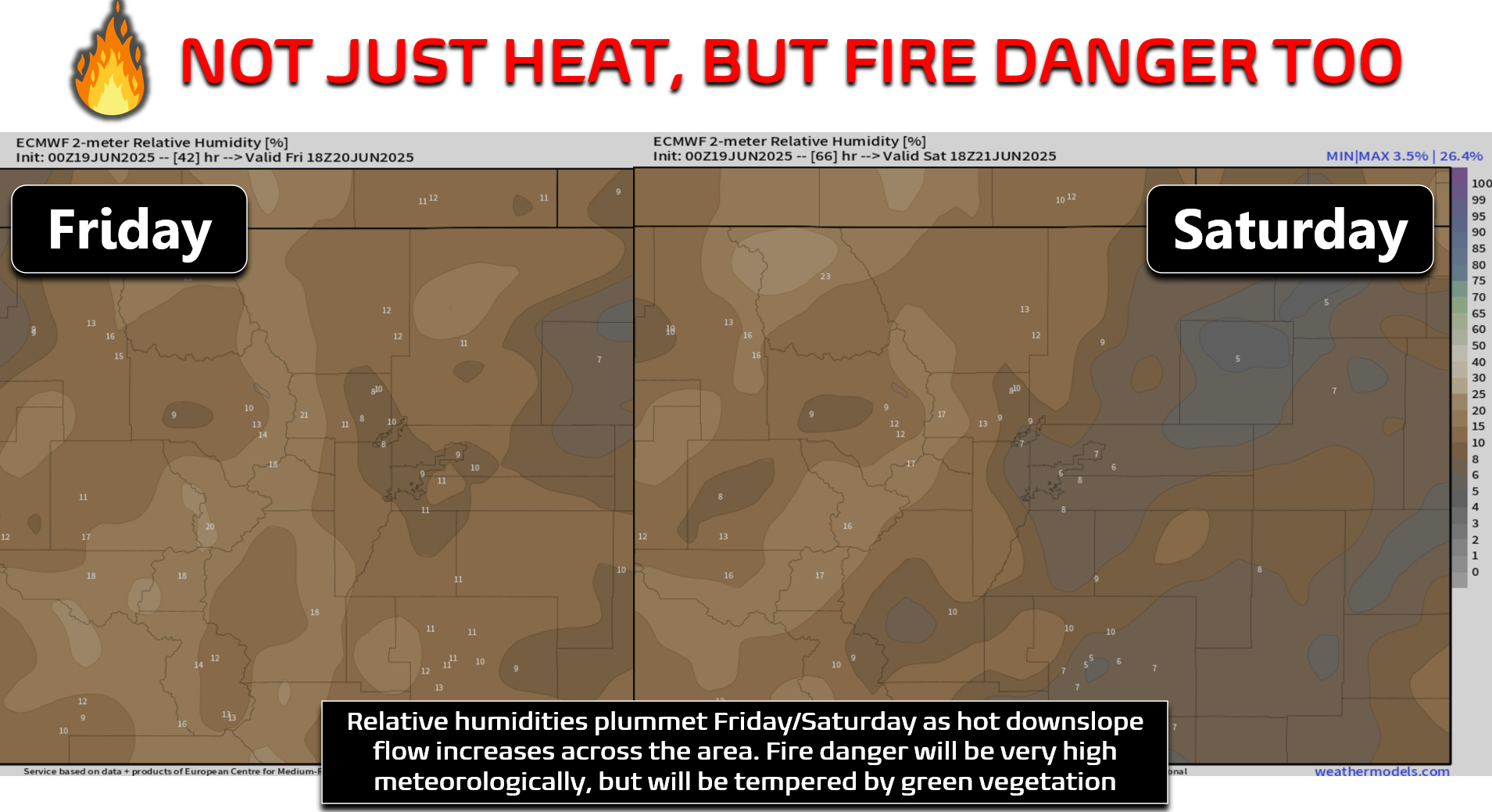
- Fire danger will be elevated at times due to gusty, bone-dry downslope winds (20–30 MPH) and very low humidity (below 10%), especially on Saturday, which could bring Red Flag conditions. Fortunately our vegetation is still pretty green which will mitigate some of the risk.
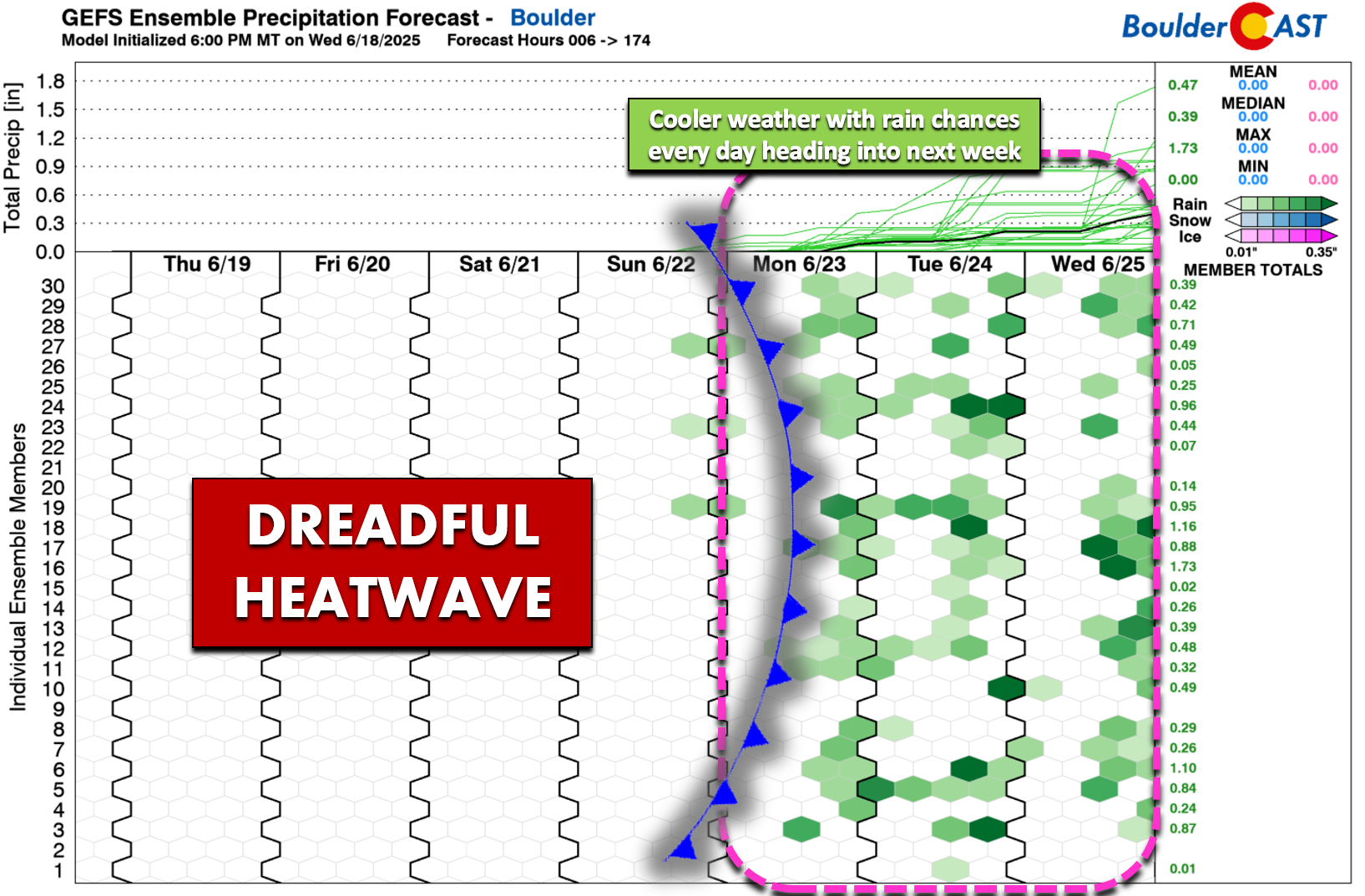
- A cooldown is on the horizon, as a trough and possible cold front arrive late Sunday into Monday, bringing much more comfortable temps (70s) and a chance of rain to start the new week.

Go Premium, get all the perks.
Daily Forecast Updates
Get our daily forecast discussion every morning delivered to your inbox.
All Our Model Data
Access to all our Colorado-centric high-resolution weather model graphics. Seriously — every one!
Ski & Hiking Forecasts
6-day forecasts for all the Colorado ski resorts, plus more than 120 hiking trails, including every 14er.
Smoke Forecasts
Wildfire smoke concentration predictions up to 72 hours into the future.
Exclusive Content
Weekend outlooks every Thursday, bonus storm updates, historical data and much more!
No Advertisements
Enjoy ad-free viewing on the entire site.
The heat has arrived!
It’s here—our long-anticipated heatwave is officially underway. Satellite imagery this morning shows a dome of hot, dry air firmly planted over the southwestern U.S., and it’s not going anywhere fast. Thanks to a strong ridge of high pressure, we’re looking at sunny skies, little to no rain through the weekend, and temps soaring well into the 90s every day.
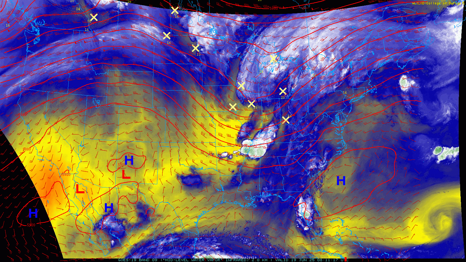
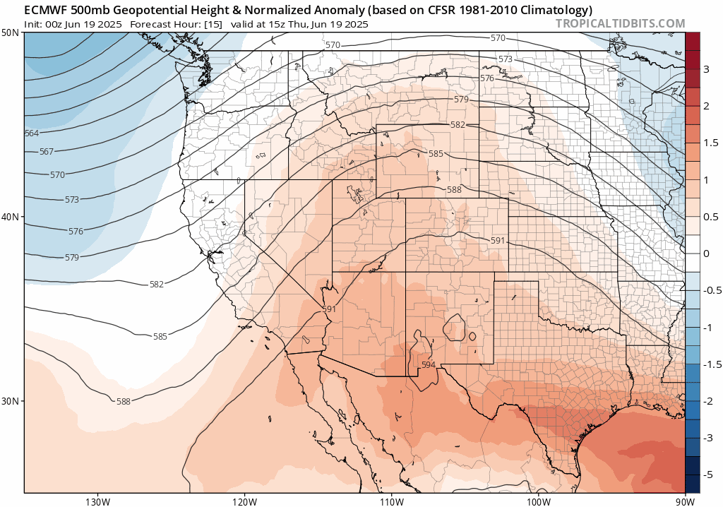
That ridge is going to shift eastward over the next couple of days, cranking up the heat even more across the eastern half of the country. Meanwhile, a pretty decent upper-level trough (for June standards!) is making its way into the Pacific Northwest and slowly heading toward Colorado. It’s actually moving a bit faster than earlier forecasts had suggested. While it won’t shake things up too much just yet, it may help bring slightly cooler temps Saturday and Sunday. But make no mistake—Friday’s still shaping up to be the hottest day of the stretch near 100 degrees!
Ensembles were previously showing both Friday and Saturday having nearly 100% odds to exceed 100° in their runs initialized earlier in the week. For example, this GFS ensemble run from Sunday night below. Notice the forecast values for June 20th and 21st:
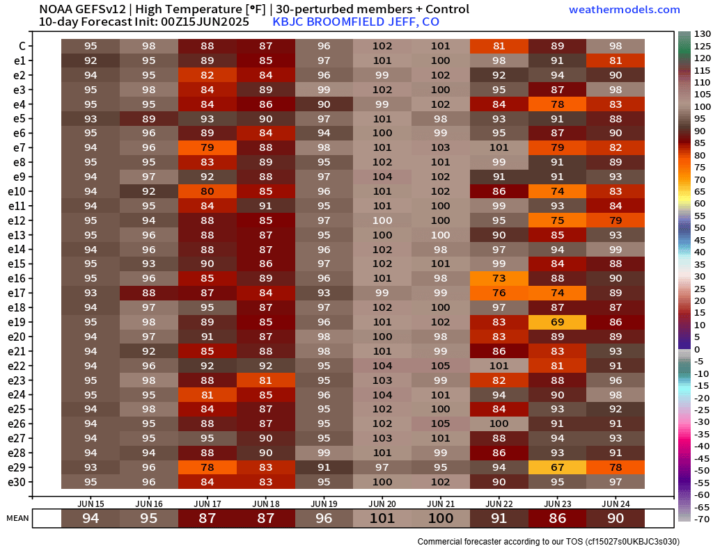
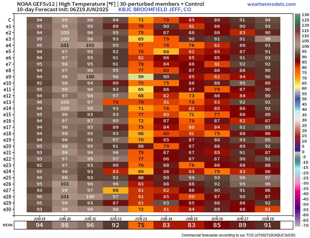
Now, the latest ensembles all agree that it won’t be quite that hot, with highs Friday and Saturday coming in a bit lower due to the approaching trough. We’re still expecting widespread mid to upper 90s, and yes, a few spots will probably still flirt with or eclipse 100°, but it’s not quite the scorcher we initially feared.
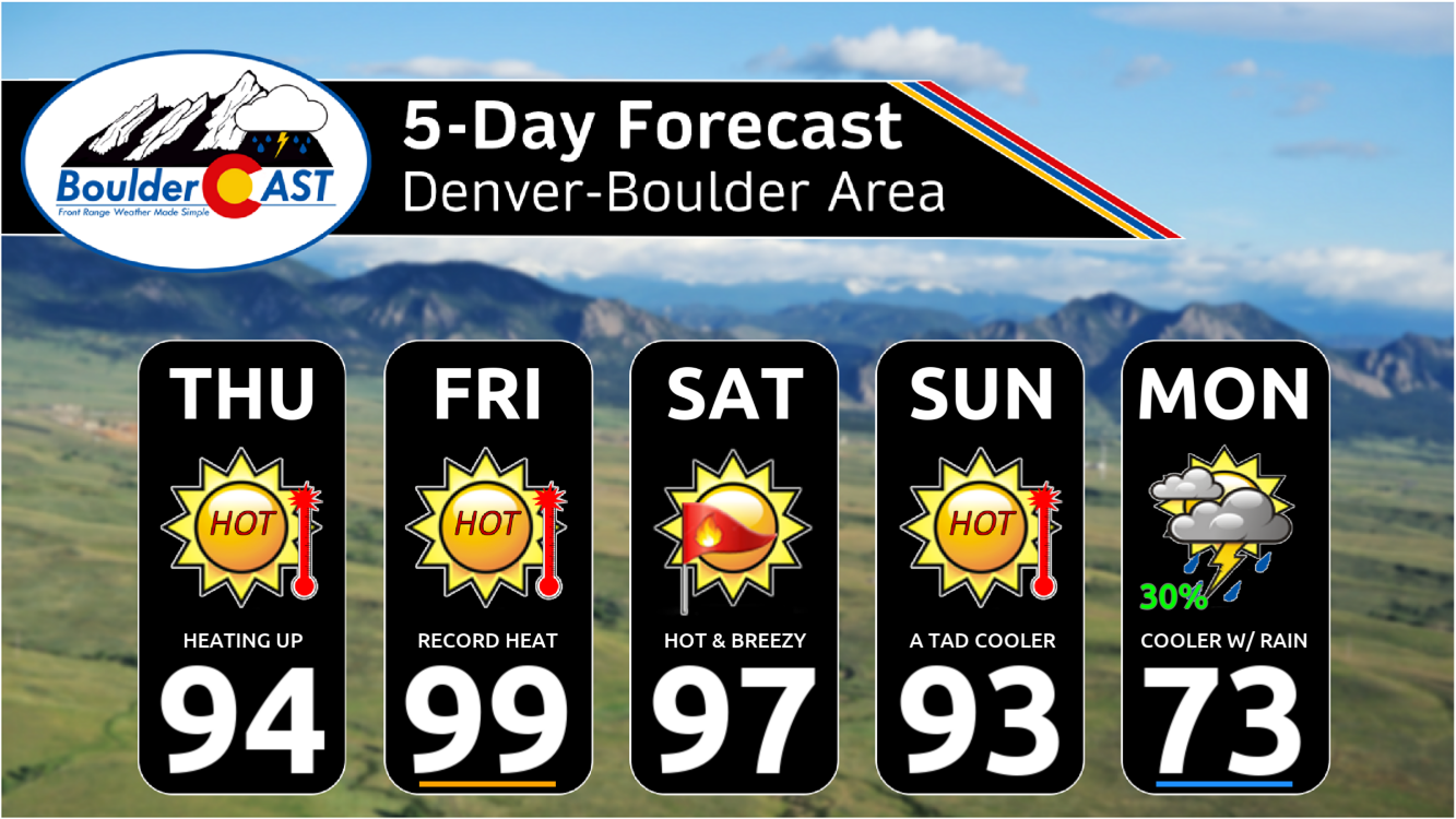
Thursday kicks off the dreaded heatwave we’ve been discussing all week long. High pressure will continue to build to our south, with Colorado on the far northern periphery of its influence. This ridge will allow temperatures to soar into the middle 90s across the lower elevations with mostly sunny skies.
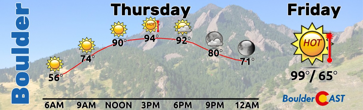
Come Friday, brace yourselves—it’s likely to be the peak of the heatwave, with highs ranging from 97 to 101°F. Saturday eases up just a little as heights fall and slight cooling takes place aloft with the approaching trough but we will still be baking in the mid to upper 90s. A Heat Advisory is in effect for both days, so make sure you’ve got a game plan to stay cool and hydrated.
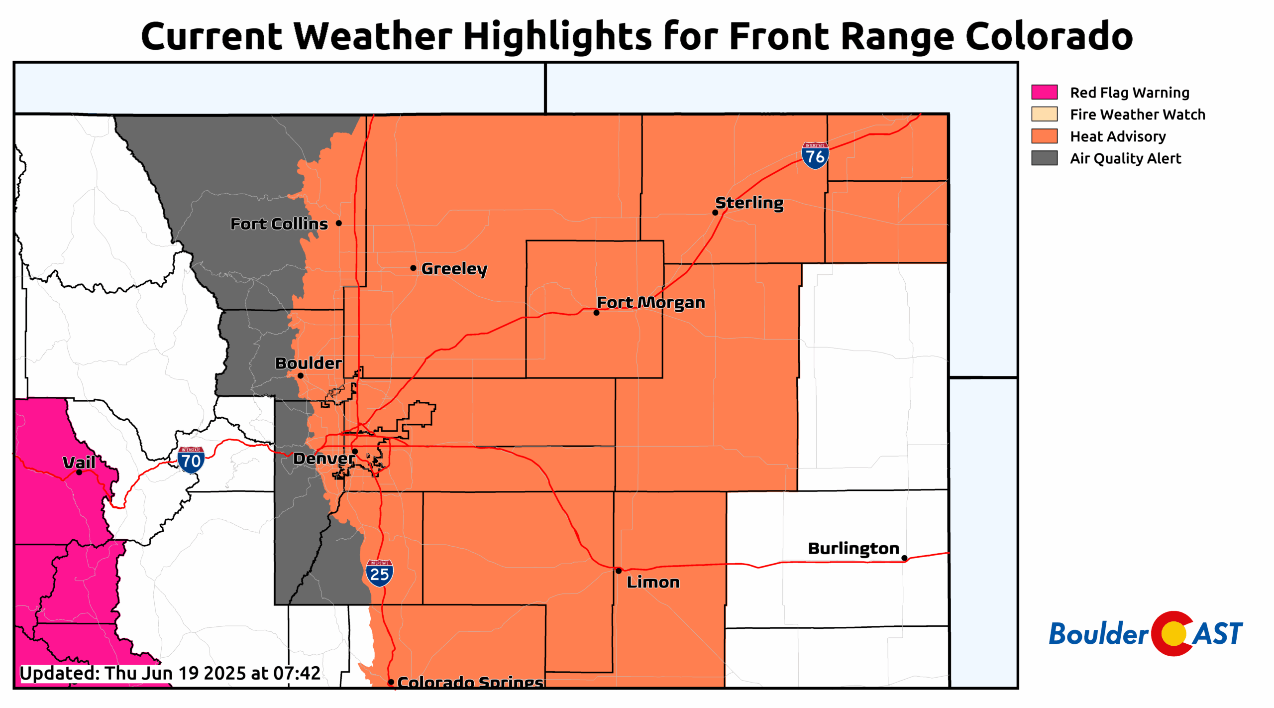
One extra thing to keep an eye on this weekend: fire danger. That same pattern driving the heatwave will also bring dry, gusty downslope winds—especially Friday and Saturday. Humidity levels will drop below 10%, and gusts between 20 to 30 MPH may kick up across the Metro area. Fuels aren’t too dry just yet, which helps, but grasses and other light fuels could still ignite very easily in these conditions. It’s something we’ll need to watch closely. Saturday will bring the driest air and more wind, and thus might be our best bet for Red Flag conditions, but it’s still uncertain.
By Sunday, the trough will start to exert more influence east of the Rockies with a cold front working south across Wyoming and Nebraska. This front (or a weak pre-front) may come through Sunday morning, then wash out or slide back north during the day, or it may hold off entirely until Sunday evening. Due to the uncertainty in how this front will behave four days out, our high temperatures on Sunday are a bit murky right now. If the front comes in strong early in the day, we may only see highs in the 80s. If the front is delayed until the evening, that’ll mean another scorching day in the mid to upper 90s. Right now our forecast straddles the middle of the guidance — with highs in the lower to middle 90s and continued sunshine.
But hang tight—relief is coming. By Monday, we’re expecting that front to bring a much cooler airmass, knocking highs down into the 70s. There’s even a shot at some rain and low clouds to kick off next week. Doesn’t that sound refreshing?
So until then, stay safe, stay hydrated, and take care of yourself and your neighbors. Cooler, stormier, and much more seasonal weather is just around the corner.
Enjoy our content? Give it a share:


You must be logged in to post a comment.