
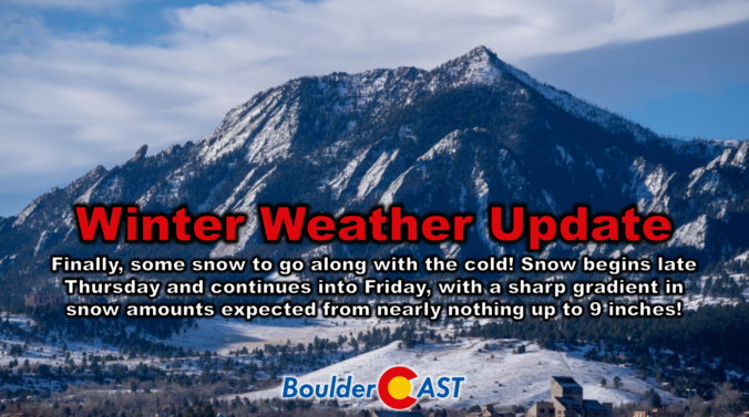
It’s been a brutally cold week in the Boulder-Denver area with temperatures remaining entirely below freezing since Saturday morning. Up until now, we haven’t had much snow to show for this Arctic plunge, but that changes later on Thursday as we finally get some moisture and a real storm system passing through to generate widespread snowfall across the Front Range. We discuss the latest forecast details, including how models have been trending the storm further south in recent runs which will make for a tricky forecast, one with a very sharp gradient in expected snowfall totals. Let’s take a look.
At a Glance
- What a Cold Week! We haven’t gotten above freezing in more than five days, culminating with record cold low temperatures Wednesday morning below zero.
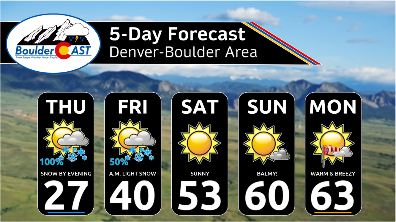
- Finally Some Snow to Show for the Cold: A quick-moving disturbance in the northwest flow will bring favorable conditions for a period of widespread snowfall late Thursday into Friday, with areas south/southwest of Denver most favored.
- Snow Timing: Snow will spread into the Mountains Thursday afternoon before making its way into the lower elevations by early evening. Snow will continue, heavy at times, through the night before coming to an end Friday morning. The Thursday evening commute likely will see some snowflakes, while the Friday morning commute will be very slick, especially south of Interstate 70.
- Snow Amounts: A sharp gradient in snow amounts will exist from southwest (highest) to northeast (lowest) across the Front Range. Most of the Boulder/Denver area can expect 2-6″ of snow, though be sure to check your location on our snowfall map!
- The End is Near! After the storm exits on Friday, a big toasty ridge will take over this weekend into early next week. Temperatures will quickly return to the 50s by Saturday with 60s to follow Sunday and beyond

Go Premium, get all the perks.
Daily Forecast Updates
Get our daily forecast discussion every morning delivered to your inbox.
All Our Model Data
Access to all our Colorado-centric high-resolution weather model graphics. Seriously — every one!
Ski & Hiking Forecasts
6-day forecasts for all the Colorado ski resorts, plus more than 120 hiking trails, including every 14er.
Smoke Forecasts
Wildfire smoke concentration predictions up to 72 hours into the future.
Exclusive Content
Weekend outlooks every Thursday, bonus storm updates, historical data and much more!
No Advertisements
Enjoy ad-free viewing on the entire site.
Finally some snow to go with the bitter cold!
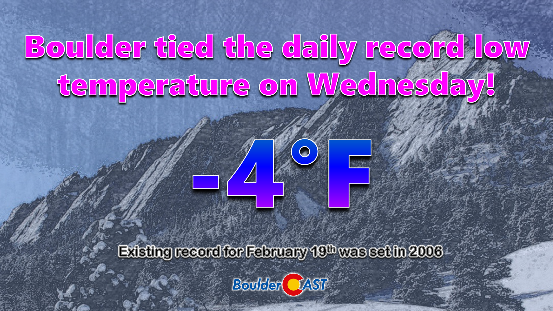
Can you believe that the last time we were above freezing in Boulder was way back early Saturday morning, more than 120 hours ago? Since then, we’ve been kept in a deep freeze by several cold fronts, some Arctic in origin, facilitating temperatures way below seasonal normals throughout the entire week. The cold culminated with Boulder tying the daily record low temperature Wednesday morning at -4°F, which was previously achieved in 2006.
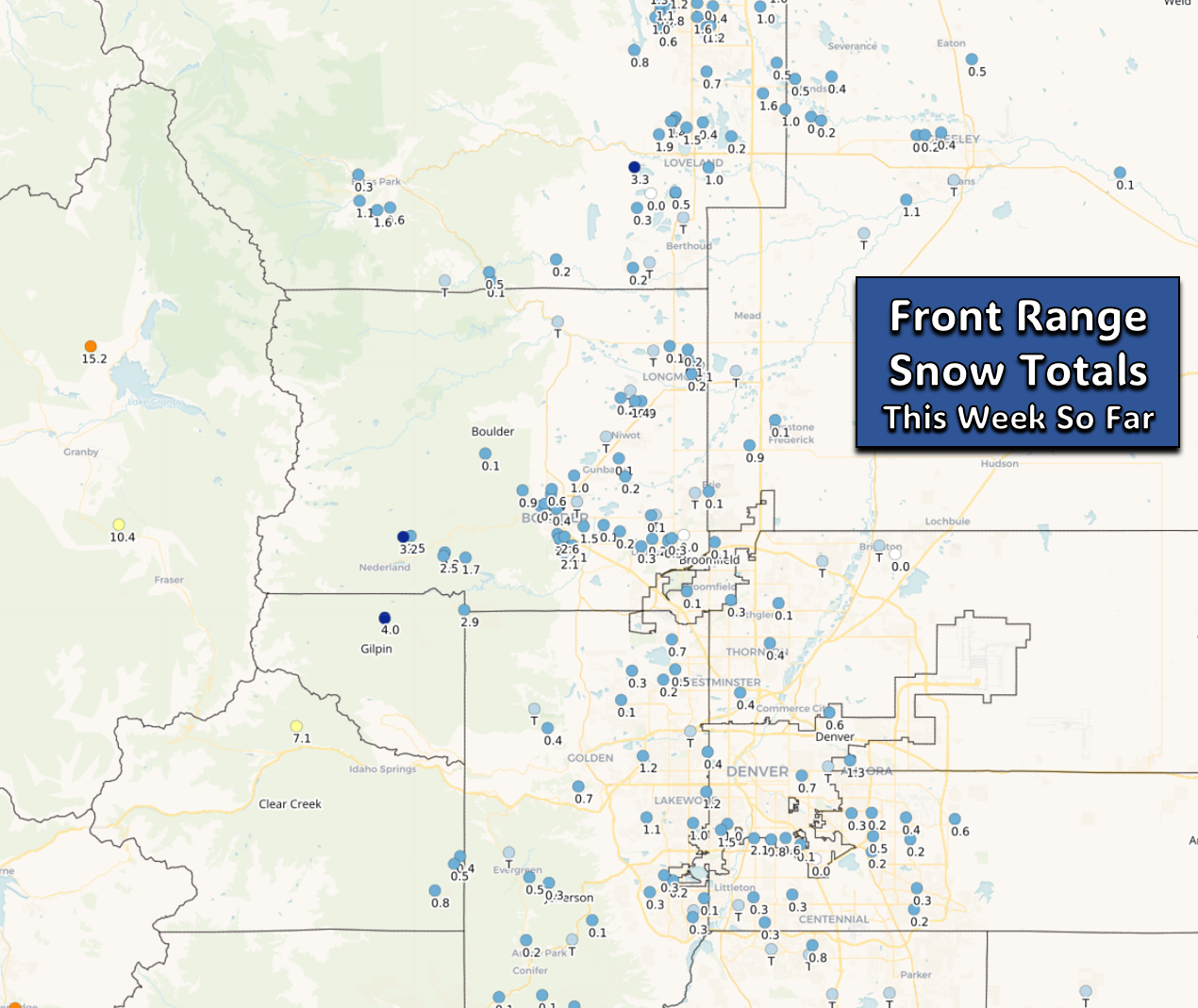
Thus far, we haven’t had much actual snowfall to show for this ongoing cold stretch. Most of the Denver Metro area has picked up just a trace to 2 inches of snowfall thus far, not a whole lot considering light snow and/or flurries have been falling much of the time this week in many areas.
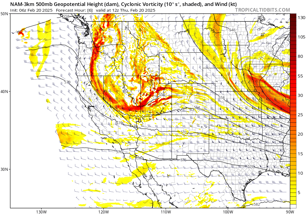
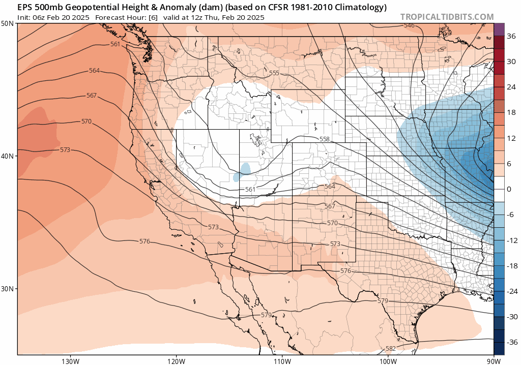
The lack of snowfall accompanying the lengthy cold spell ends today, however, as a Pacific storm system eyes the Front Range. After a brief period of shortwave ridging which brought us the sunny (but still cold!) weather on Wednesday, a quick-moving disturbance will slide into Colorado Thursday evening setting the stage for a round of widespread snowfall! The disturbance can be seen in the 500mb vorticity forecast animation below, moving from the Salt Lake City area Thursday morning into Denver by late Thursday night. As the storm gets into Colorado, it will form a tightly-knit closed low just to our south, with favorable upslope flow commencing across our area Thursday evening into Friday morning.
Unlike the bitter cold (and dry) Arctic airmass we’ve been stuck in all week, this system will usher in warmer air from the west with more moisture, wrapping it back into Boulder and Denver Thursday evening and night as the low pressure develops and passes to our south. In the process, much of the area should be able to squeeze out a few inches of snowfall by Friday afternoon!
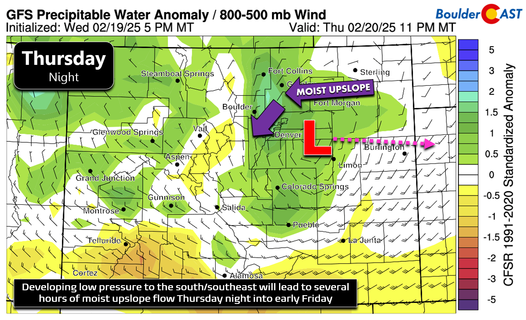
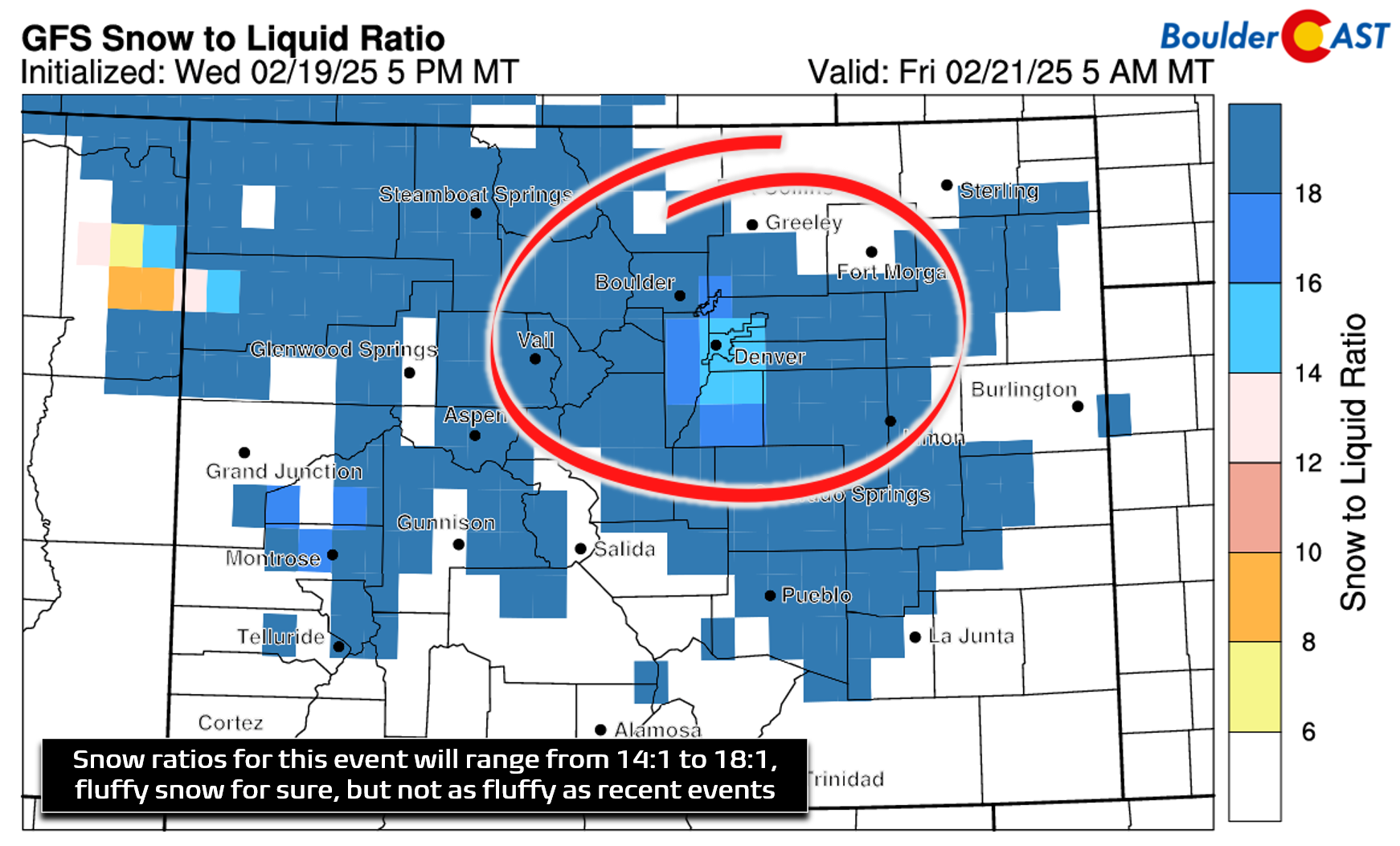
The forecast for this event isn’t going to be an easy one, as usual. We’ve seen this system shift in the models from nearly a non-event a few days ago towards a borderline significant snowstorm for the Metro area in short order. The models are coming in a bit hot on this one, though we have seen better consistency over the last 24 hours across the board. The overall trend has been for the system to track just slightly further south, with winds coming more from the north than the east into our area. This has resulted in the heaviest precipitation bullseye shifting ever-so-slightly southward, now being focused on the Palmer Divide and southern Foothills, which will benefit most from north-northeast upslope and closer proximity to the petite low pressure. There’s likely to be a sharp gradient in snow amounts heading north and east out of Denver and Boulder, tapering off to nearly nothing within just 25 miles.
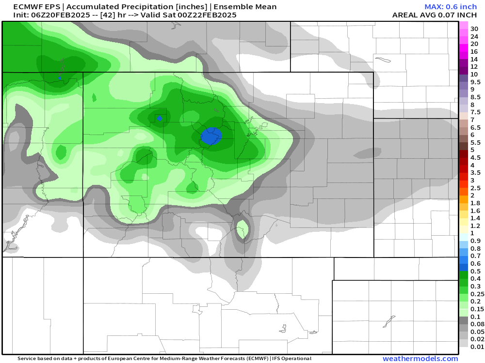
Let’s run through some of the latest model data to inform us about potential precipitation amounts. The 50-member European ensemble mean shows 0.1 to 0.3″ for the Metro area, with greater amounts south/west across the higher terrain.
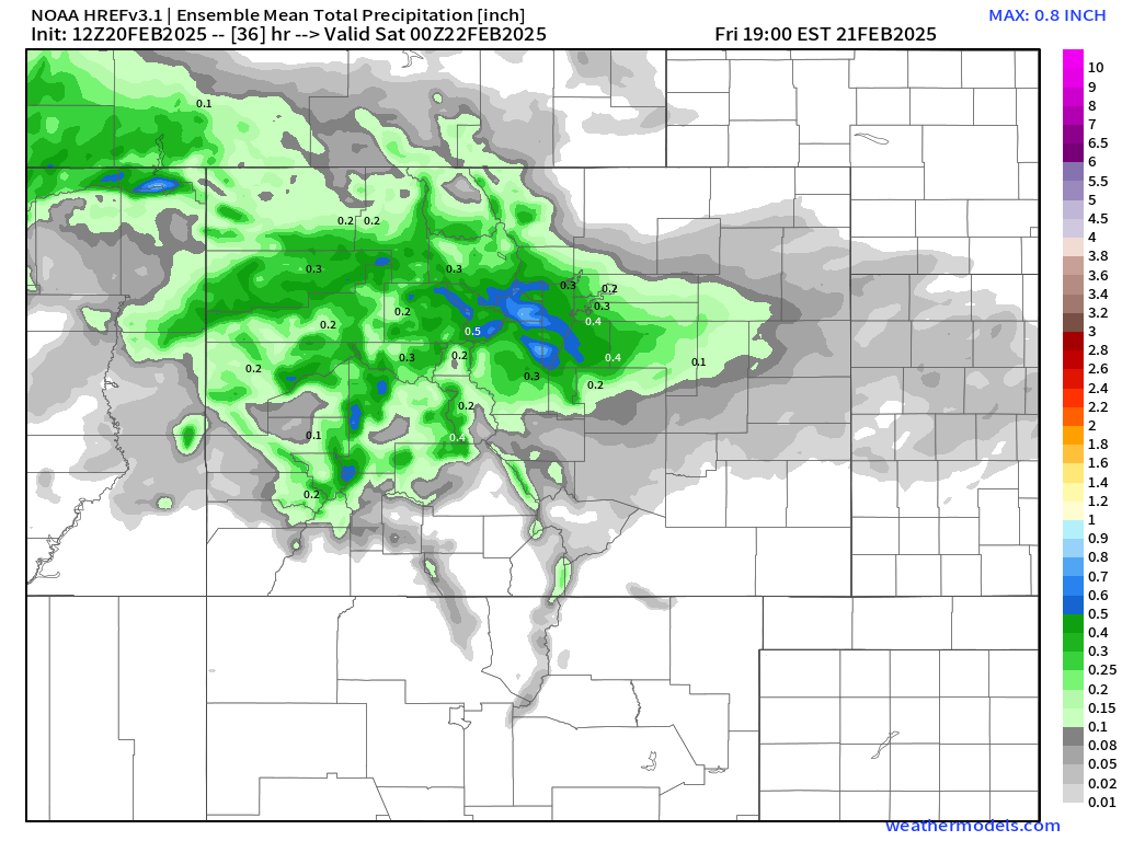
The high-resolution ensemble forecast (HREF) precipitation distribution is very similar, but about 25% higher on amounts. Once again, the areas south and west of Boulder/Denver area favored. The higher-resolution really amplifies the expected gradient!
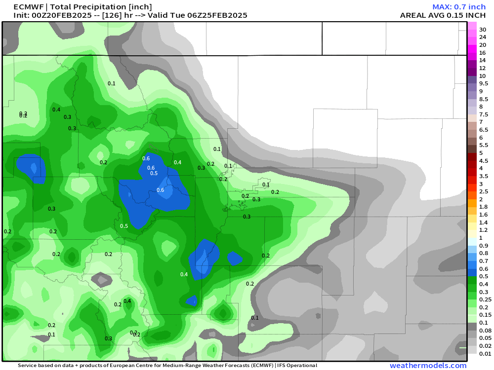
Finally, the almighty European operational run. It matches closely with its ensemble consensus, producing precipitation amounts between 0.1 and 0.3″ for the area, with up to 0.5″ in the southern Foothills and Palmer Divide.
Temperatures will be several degrees warmer for this storm with Pacific air infused into it, dropping from the 20s into the teens as snow falls Thursday evening and night. Thus, snow ratios won’t be quite as high as other recent and colder events, but we’re still expecting a decent ratio around 15:1 or slightly higher. Multiply those precipitation amounts above by the expected ~15:1 ratio, and we end up with a broad brush of a few inches of snowfall for most of the area.
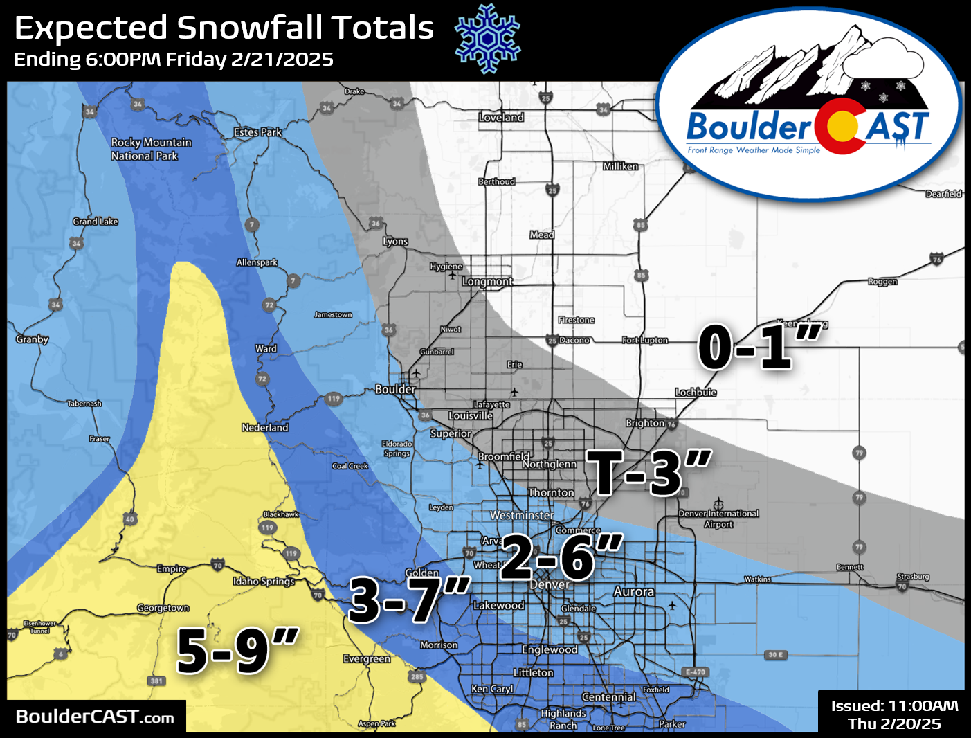
Our snowfall forecast map is shown below, covering all the white stuff falling from Thursday afternoon into Friday morning. The highest totals are expected in the Foothills of Jefferson, Gilpin and Clear Creek Counties, up to 9 inches. This includes a hefty dumping right on the I-70 Corridor between Golden and the Eisenhower Tunnel — plan on quite the mess if you’re traveling up that way during the height of the storm! 1 to 6 will fall in Boulder and Denver with amounts quickly falling off to the northeast. We believe the forecast for the Boulder area is particularly uncertain, as recent model trends have really tanked our snow amounts, with some runs even showing less than 2 inches (say it ain’t so!). This is another situation where southwest Boulder stands to pick up noticeably more than northeast Boulder — perhaps a dusting to 2″ around Gunbarrel, but 2-4″ southwest? Ultimately, this sharp gradient will keep the boom and bust potential high for this event. If this system trends any further south, this could end up being a complete flop for much of the region!
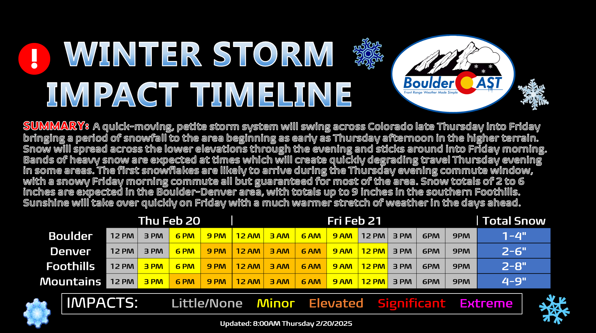
As far as timing, snow will begin to spread into the Mountains Thursday afternoon before making its way east across the Foothills and lower elevations by early evening. There is still some uncertainty in regards to the onset timing and its impacts for the Thursday evening commute. Better to play it safe and leave work a little early if possible. It’s looking like much of the area will see snow start falling by the end of the P.M. commute window. Snow will continue, heavy at times, throughout the night, eventually tapering off through the morning Friday. The A.M. commute is likely to be quite snowy south of Interstate 70 and across the higher terrain. Plan on a very slow-and-go morning drive to end the work week!

Our impact timeline below highlights the difficult travel, with the worst conditions expected from 9PM Thursday to 6AM Friday in most locations.
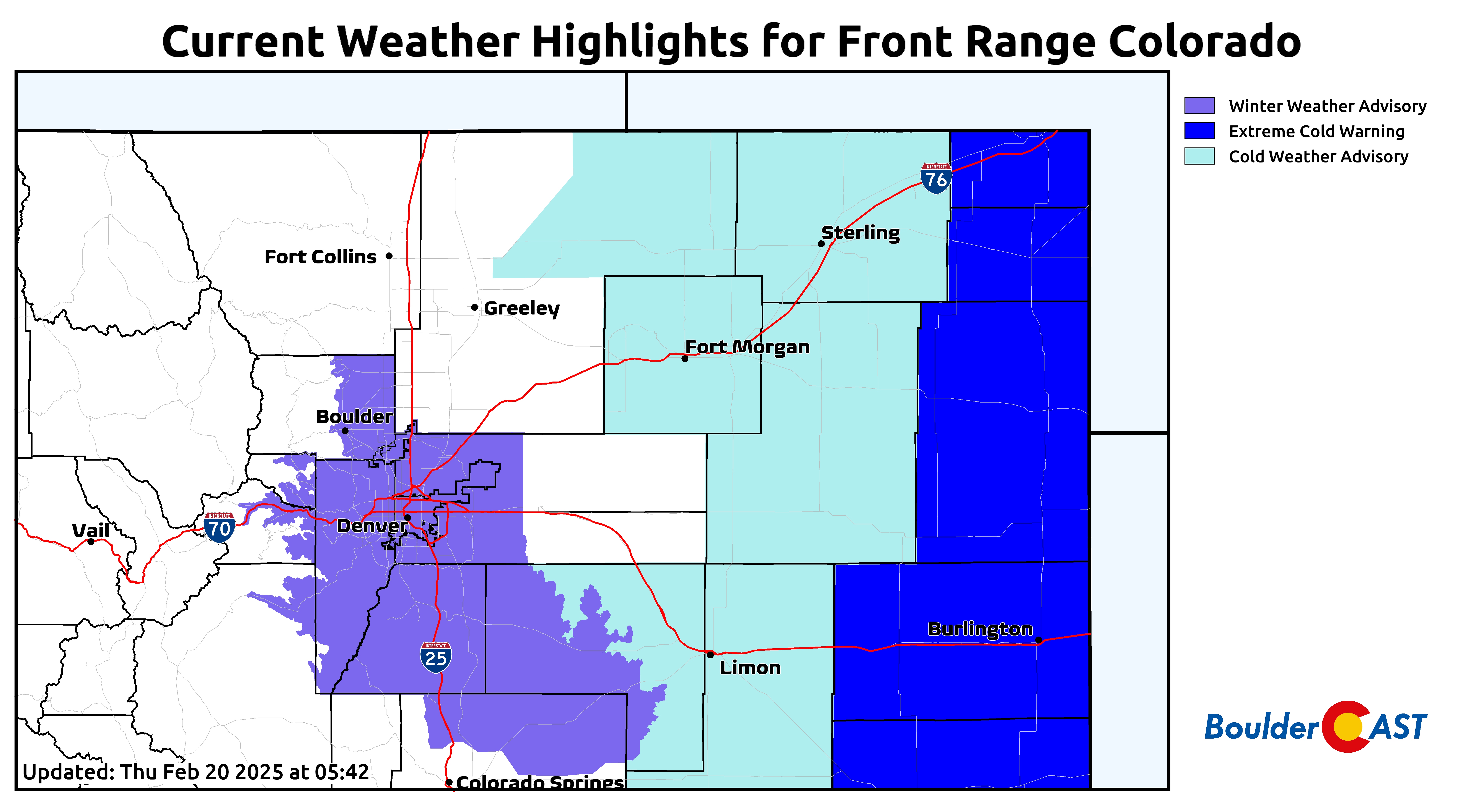
Winter Weather Advisories are posted for Boulder, Denver and the entire southern Front Range due to the expected low to moderate wintry impacts spanning two commutes. The cold-related highlights for early Thursday to the east will expire before the snow arrives.
Ironically, the parent storm system bringing us this late-week snow will be the one to finally oust the Arctic airmass that has been plaguing the area for the last five days. As the storm departs on Friday, a strong ridge will follow right behind it this weekend, with this ridge set to linger well into next week. Warmer weather and sunshine will take over quickly, even beginning as early as Friday afternoon with our first trip back above freezing in ages.
Temperatures will return into the 50s by Saturday, with 60s to follow Sunday and Monday (and likely more days next week). After the prolonged deep freeze, I think we’re overdue for a few really nice days, don’t you think?
Enjoy the transition from the Arctic back to spring-like conditions — there’s just a little bit of snow in between. That’s all for now. Come follow us on Twitter, Bluesky, Facebook, and Threads for impromptu weather updates as the snowfall event unfolds, or subscribe to get notified of our long-form forecast discussions here.
Get BoulderCAST updates delivered to your inbox:
Go Premium, get all the perks.
Daily Forecast Updates
Get our daily forecast discussion every morning delivered to your inbox.
All Our Model Data
Access to all our Colorado-centric high-resolution weather model graphics. Seriously — every one!
Ski & Hiking Forecasts
6-day forecasts for all the Colorado ski resorts, plus more than 120 hiking trails, including every 14er.
Smoke Forecasts
Wildfire smoke concentration predictions up to 72 hours into the future.
Exclusive Content
Weekend outlooks every Thursday, bonus storm updates, historical data and much more!
No Advertisements
Enjoy ad-free viewing on the entire site.
Enjoy our content? Give it a share:


You must be logged in to post a comment.