This last full week of June will feature hot temperatures to start followed by a cooldown late-week along with increasing chances of showers and storms. Ridging will largely be in place early on, but an approaching low pressure system and cold front will return us to more unsettled conditions by week’s end. There will also be some gusty winds Tuesday for raising marginal fire concerns. Read on for all the details.
This week’s highlights include:
- A warm and dry start to the week with upper 80s to lower 90s
- Boulder and Denver both in the hunt for their first 90-degree day of the year and likely get it either Monday or Tuesday
- Hot and dry with gusty winds Tuesday may elevate concerns for fire weather
- Storm chances increase late in the week with a southward moving front, along with notably cooler temperatures by week’s end
DISCLAIMER: This weekly outlook forecast is created Monday morning and covers the entire upcoming week. Accuracy will decrease as the week progresses as this post is NOT updated. To receive daily updated forecasts from our team, among many other perks, subscribe to BoulderCAST Premium.
Daily Forecast Updates
Get our daily forecast discussion every morning delivered to your inbox.
All Our Model Data
Access to all our Colorado-centric high-resolution weather model graphics. Seriously — every one!
Ski & Hiking Forecasts
6-day forecasts for all the Colorado ski resorts, plus more than 120 hiking trails, including every 14er.
Smoke Forecasts
Wildfire smoke concentration predictions up to 72 hours into the future.
Exclusive Content
Weekend outlooks every Thursday, bonus storm updates, historical data and much more!
No Advertisements
Enjoy ad-free viewing on the entire site.
Dry & borderline hot to start
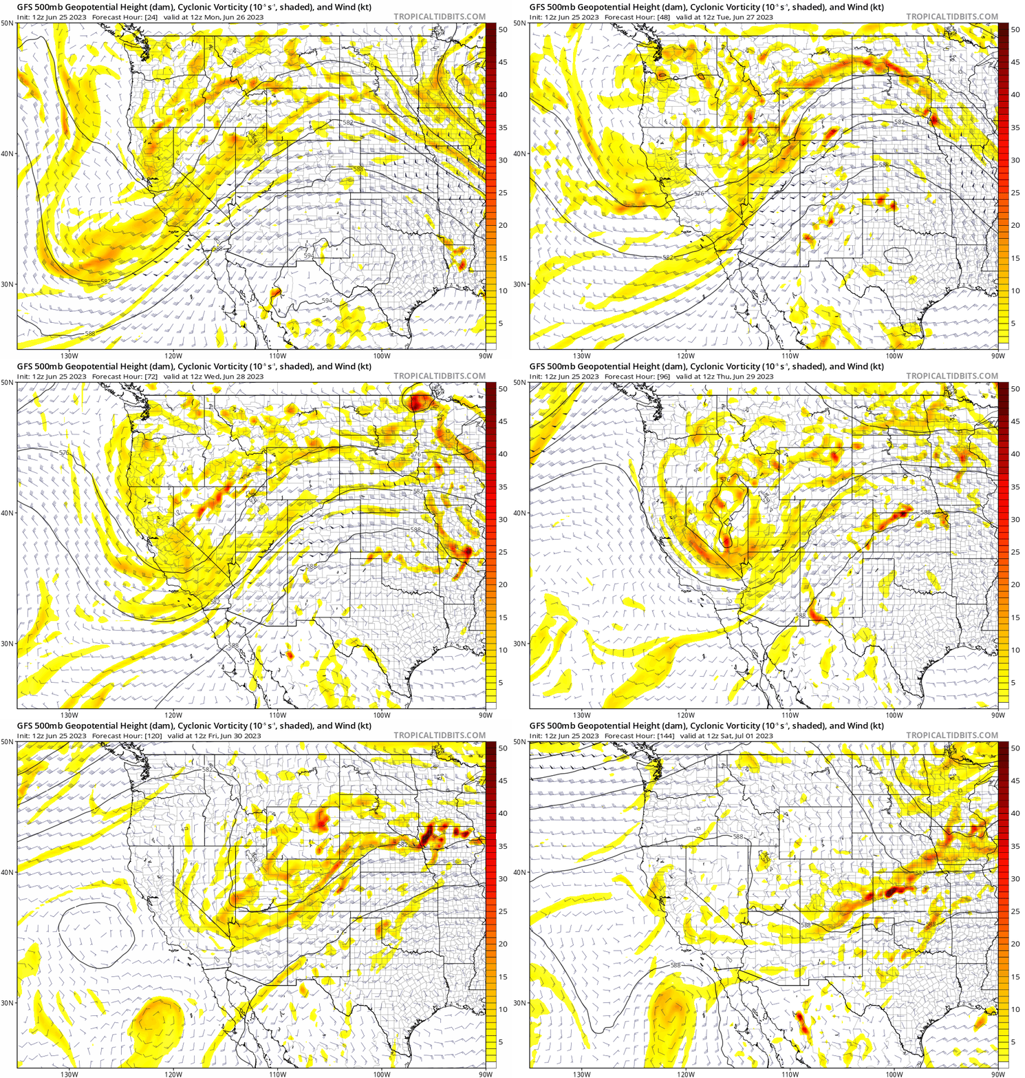
It is hard to believe that this is the last full week of June. The first part of summer is going by pretty fast! If you don’t stop to smell the roses or hike the mountains, the summer may get away from you! This last week of June will feature a rather quiet but warm start. As the animation shows below, a persistent ridge of high pressure over the southern Plains and a mid-level shortwave near California/Utah will usher in a warm and dry southwest flow over the state. As the week progresses, however, that shortwave will slide eastward, especially late Thursday and Friday, creating more unsettled weather allowing for showers and storms to return. As the system then exits into the Midwest for the weekend, we may see a return to drier weather with perhaps slightly below normal highs lingering.
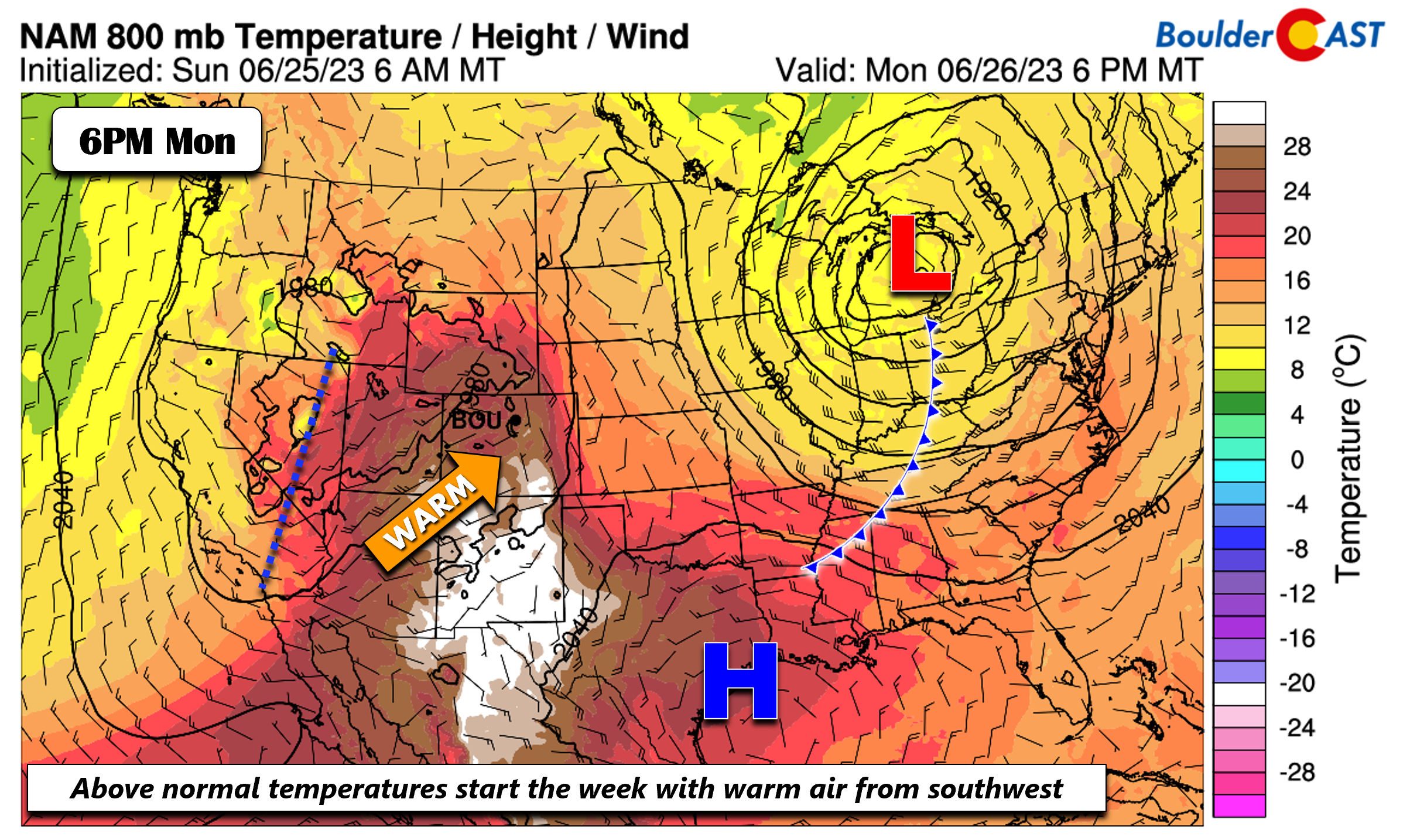
At the low-levels across the nation on Monday, a strong area of low pressure is located over the Great Lakes, with a trailing cold front into the Tennessee Valley. Ridging is over southeastern Texas, while a trough axis sits across Utah. A warm and dry southwest flow today into Colorado will spell out upper 80s in most of the Front Range, with perhaps some 90-degree temperatures too.
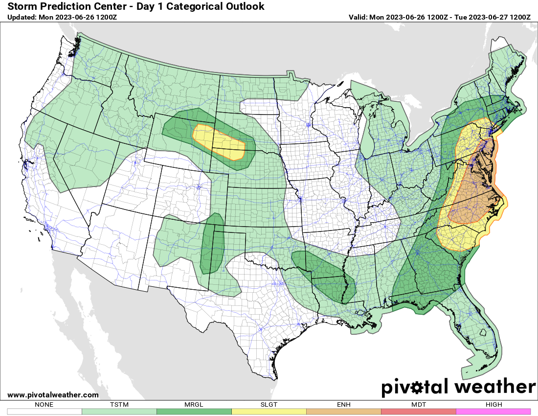
The cold front over the Tennessee Valley will spawn a severe weather outbreak over the Carolinas and into Virginia, with large swaths of damaging winds and large hail all possible.
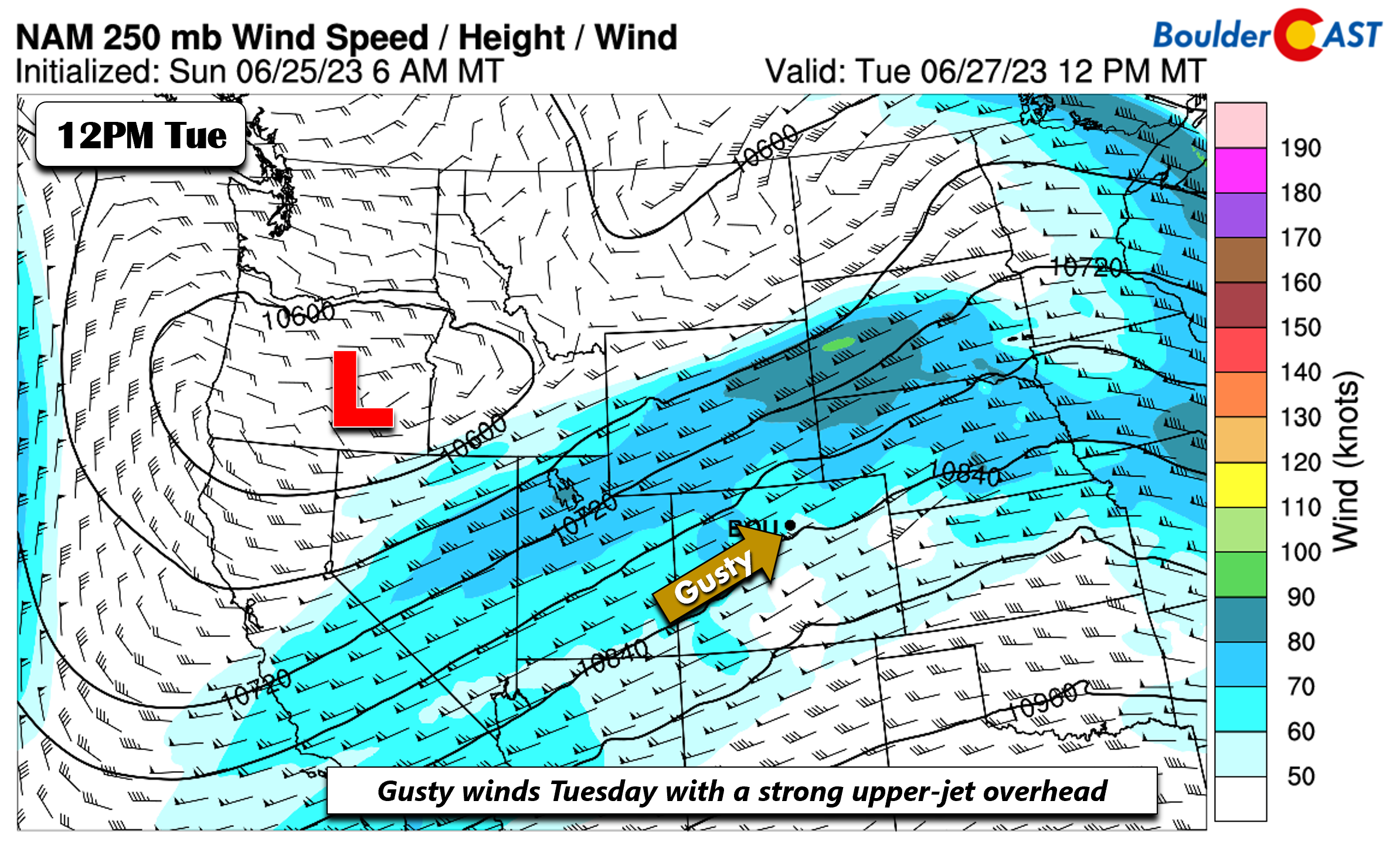
For Tuesday, an upper-level jet around 75 MPH will overspread the state and Wyoming. Surface flow will be downslope. Good mixing during the daytime will favor some gusty winds on the Plains in the 30 to 35 MPH range at times.
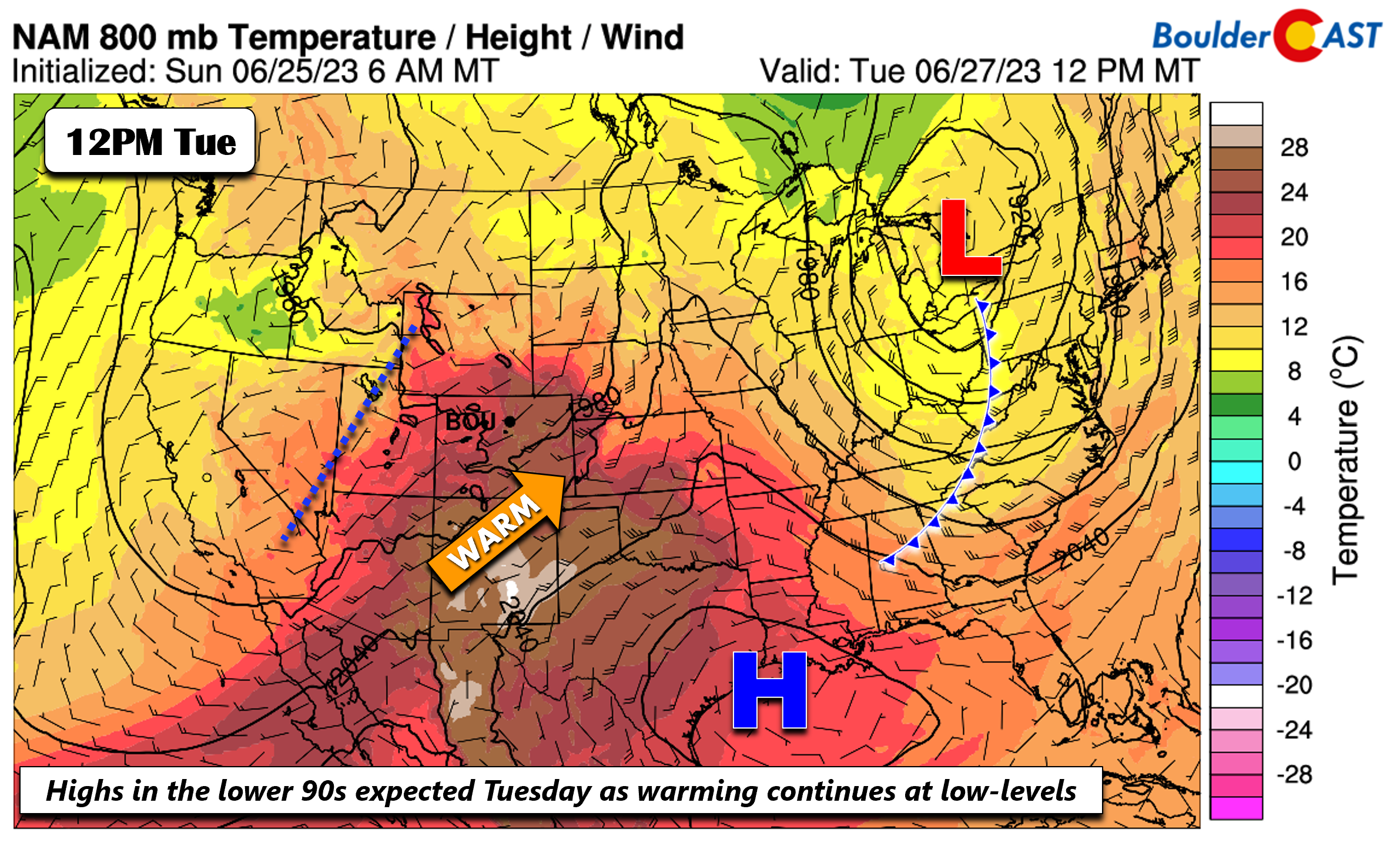
The gusty winds on Tuesday combined with lower 90s over the Denver Metro area will potentially increase fire concerns with a warm, dry, and breezy surface pattern. The fuels are so lush and wet right now that fire ignitions would be highly unlikely. We also cannot rule out a stray storm east of Denver but Boulder and Denver will be bone dry with a capping inversion suppressing any storms.
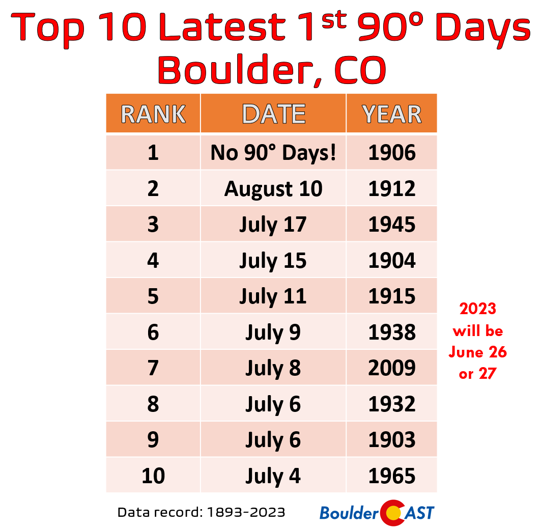
Both Boulder and Denver are still officially in the hunt for their first 90-degree day of the year! If we don’t get it on Monday — it should come instead on Tuesday.
While this timing of our first 90-degree day is towards the later part of climatology, it would be far from record-breaking. The record latest 90-degree day in Boulder is more than 115 years old and is actually undefined as 1906 had NO 90-degree days! In fact, 2023 won’t even make the top 10:
By midweek on Wednesday, a pre-frontal trough in the models is poised to slide down from the upper Great Plains. With a more northerly component to the wind and some reduction in the airmass warmth, upper 80s will be expected, somewhat lower than Tuesday’s highs in the 90s.
🔥Today is the 11 year anniversary of the Flagstaff Fire in #Boulder. It was sparked by a monsoon lightning strike amidst a terrible statewide drought. In the end, the wildfire burned about 350 acres and forever changed the landscape of Bear and South Boulder Peaks! #COWx pic.twitter.com/Cl69x1bZPs
— BoulderCAST Weather (@BoulderCAST) June 26, 2023
Storms return with approaching cold front late-week
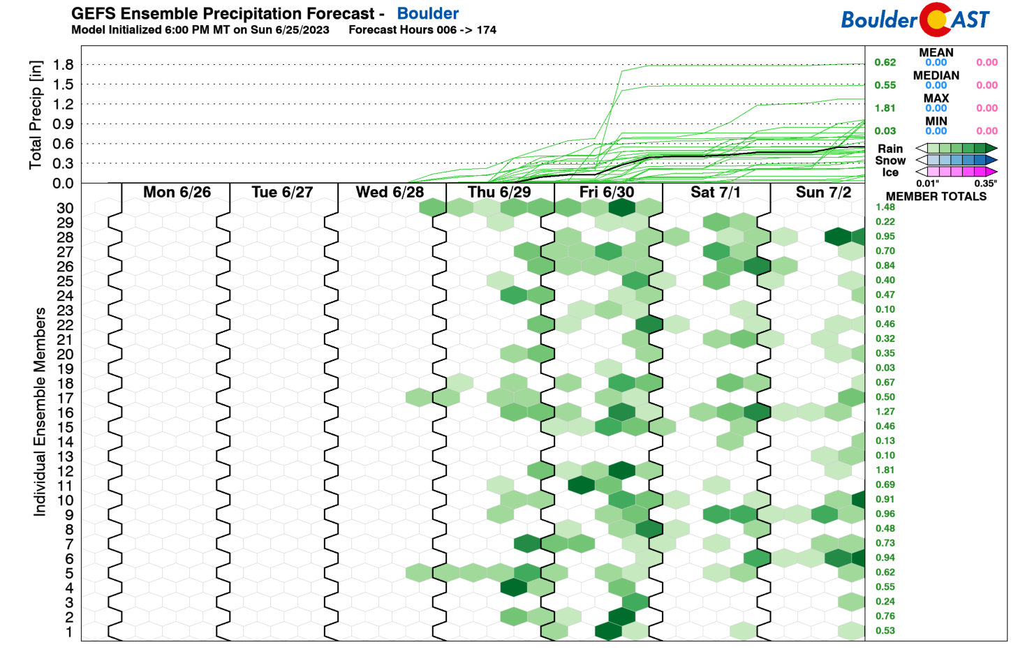
While we cannot rule out a stray storm Tuesday or Wednesday, we think the better chance of any activity will be late in the week, especially Thursday and Friday. The GEFS also indicates this below, showing more ensemble members with measurable rainfall. Nevertheless, there is still a fair bit of uncertainty given the lack of members in full agreement.
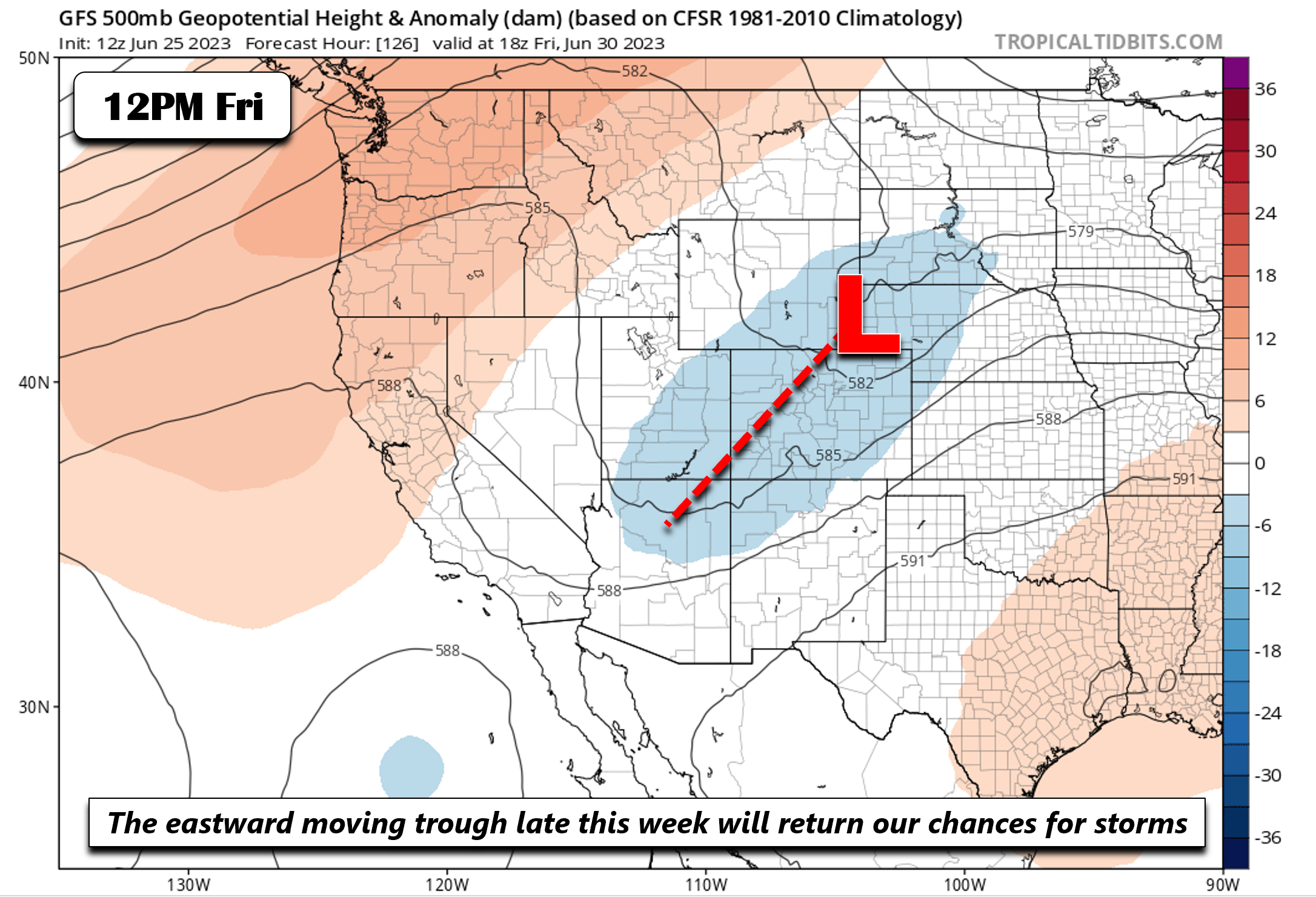
But looking at the overall weather pattern, the models show that trough out west finally shifting our way late Thursday and Friday. As this happens, the capping inversion should weaken and allow storms to better fire during the afternoon and evening hours.
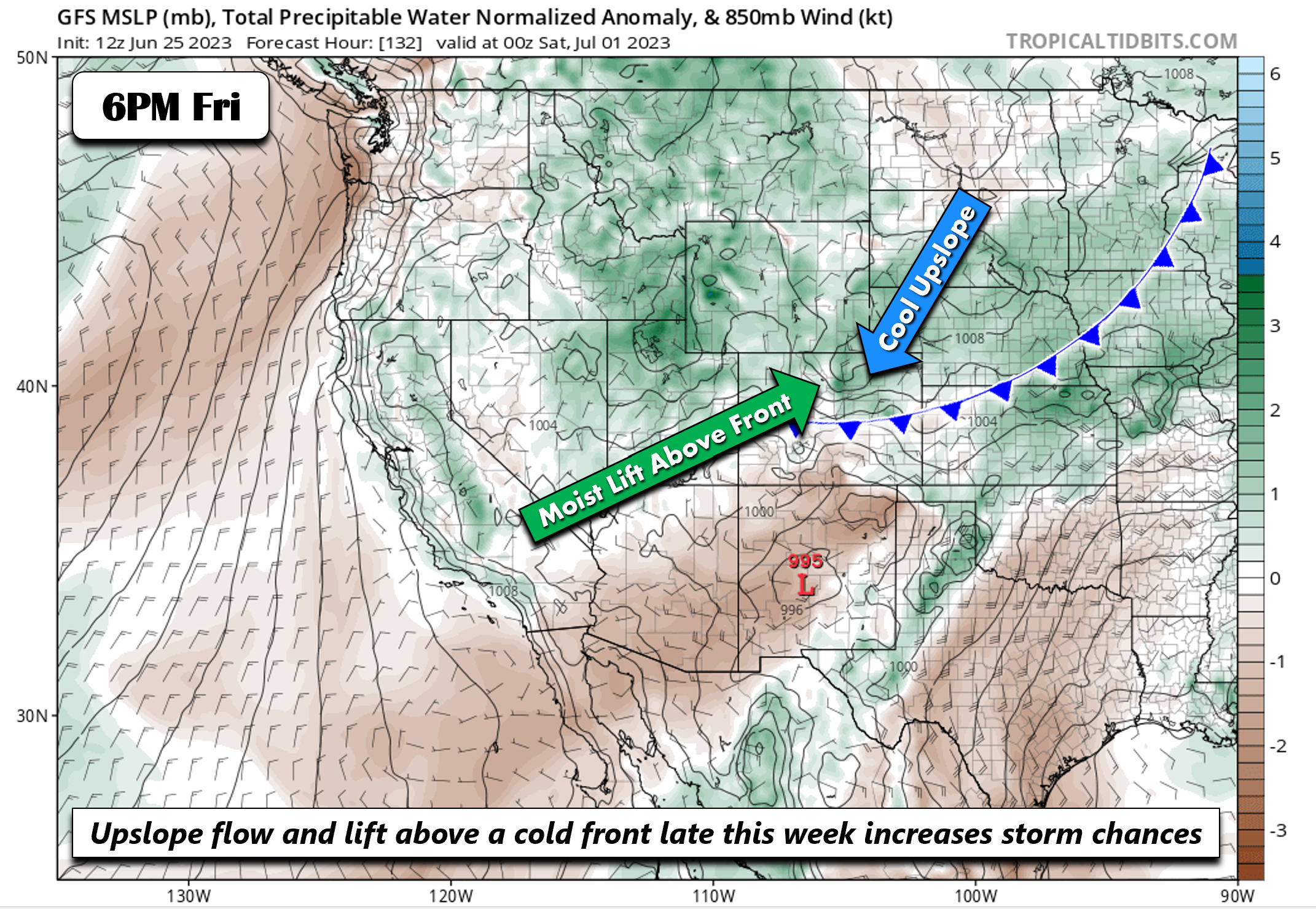
At the surface, guidance shows a southward moving cool front that will reach southeastern portions of our state Friday afternoon. As this happens, a strong upslope flow will ensue in the Denver area. Deeper moisture aloft will also spread overhead to combine with the trough to increase our shower/storm chances. There is the threat that some of the storms late in the week could be strong to severe, but it’s still too far out to make definitive conclusions. But we’ll keep you up-to-date on that as it gets closer. Highs should trend downward Thursday and Friday from the middle 80s to the upper 70s with the increasing rain chances and the frontal passage.
Enjoy the weather this week!
Forecast Specifics:
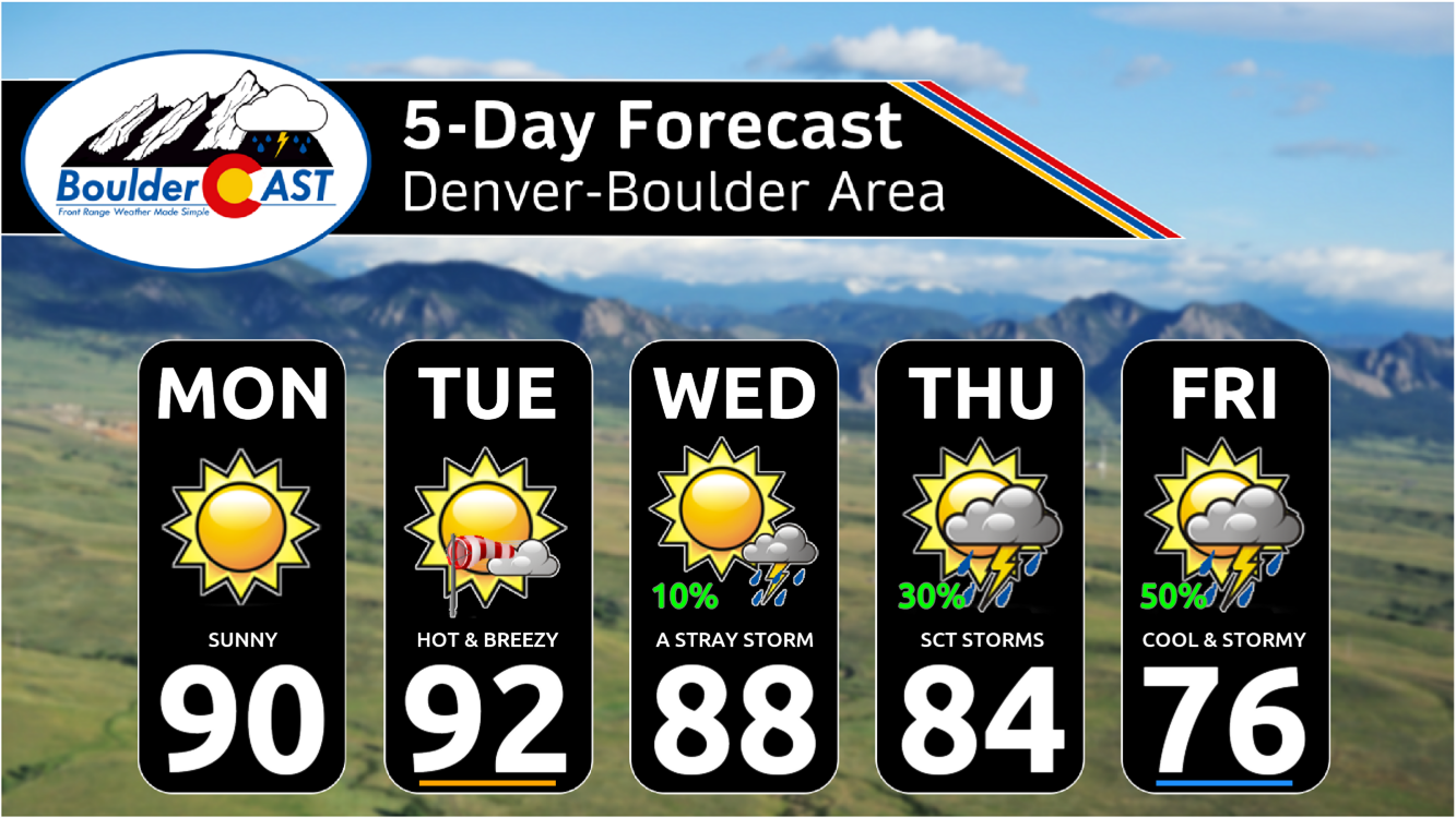
Monday: No chance of rain with mostly sunny skies and highs in the upper 80s to near 90 for the Plains and upper 70s to near 80 in the Foothills.
Tuesday: Mostly sunny, hot and breezy with lower 90s on the Plains and low 80s in the Foothills. Likely the first 90-degree day of the year for any locations that are still waiting. Southwest winds will gust up to 40 MPH on the Plains and up to 50 MPH in the Foothills.
Wednesday: Partly cloudy with upper 80s for the Plains and upper 70s in the Foothills. There is a 10% chance of a late-day storm.
Thursday: Increasing clouds with a 20-30% chance of afternoon/evening storms. Highs in the middle 80s on the Plains and middle 70s in the Foothills.
Friday: Partly to mostly cloudy with a 50% chance of afternoon/evening storms. Cooler with highs in the 70s on the Plains and 60s over the Foothills.
DISCLAIMER: This weekly outlook forecast is created Monday morning and covers the entire upcoming week. Accuracy will decrease as the week progresses as this post is NOT updated. To receive daily updated forecasts from our team, among many other perks, subscribe to BoulderCAST Premium.
Daily Forecast Updates
Get our daily forecast discussion every morning delivered to your inbox.
All Our Model Data
Access to all our Colorado-centric high-resolution weather model graphics. Seriously — every one!
Ski & Hiking Forecasts
6-day forecasts for all the Colorado ski resorts, plus more than 120 hiking trails, including every 14er.
Smoke Forecasts
Wildfire smoke concentration predictions up to 72 hours into the future.
Exclusive Content
Weekend outlooks every Thursday, bonus storm updates, historical data and much more!
No Advertisements
Enjoy ad-free viewing on the entire site.
Get BoulderCAST updates delivered to your inbox:
Enjoy our content? Give it a share!






You must be logged in to post a comment.