A major winter storm set to impact the Front Range Tuesday night through Wednesday. The heaviest snowfall will likely be focused east of Interstate 25 where up to 10″ could fall, with lesser amounts in Boulder and the Foothills. Another chance of light snow on Friday will round out a rather cold overall week for the Denver Metro area. Read on for our complete outlook of the week ahead, including our preliminary snowfall forecast map for the midweek snowstorm.
This week’s highlights include:
- Quiet Monday with temperatures in the 40s under clouds/sunshine
- A major southern-track winter storm is taking shape for Colorado Tuesday night through Wednesday
- The greatest impacts will be felt east of Interstate 25 where the best ingredients for heavy snow will come together, lesser snowfall expected in Boulder and the Foothills
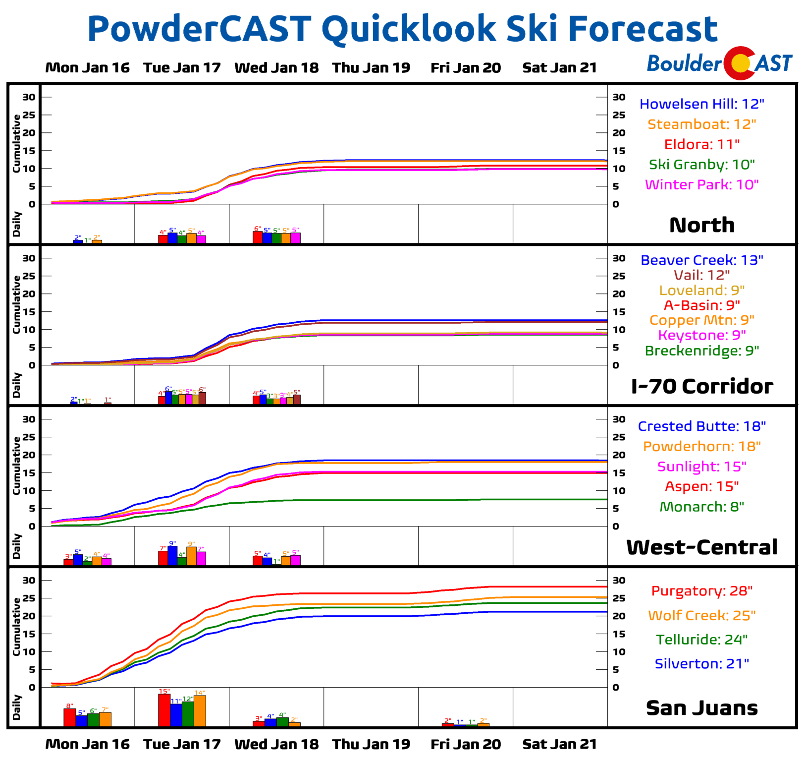
- 1 to 2 feet of snowfall in the Mountains this week, heaviest in southwest Colorado
- Another quiet day Thursday before a chance of light snow again on Friday
- Temperatures remain below normal in the 20s and 30s Tuesday through Friday — brr!

DISCLAIMER: This weekly outlook forecast is created Monday morning and covers the entire upcoming week. Accuracy will decrease as the week progresses as this post is NOT updated. To receive daily updated forecasts from our team, among many other perks, subscribe to BoulderCAST Premium.

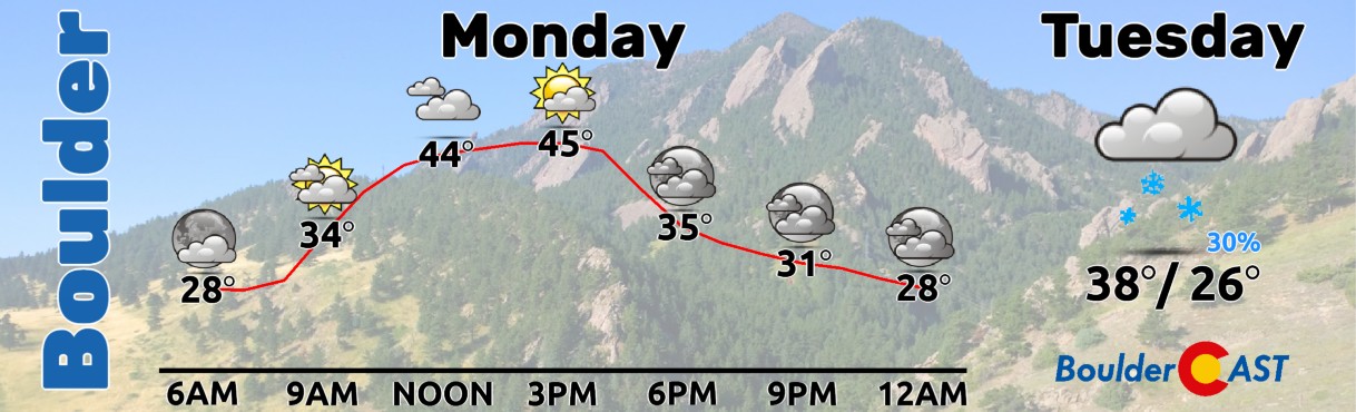
Brief lull on Monday
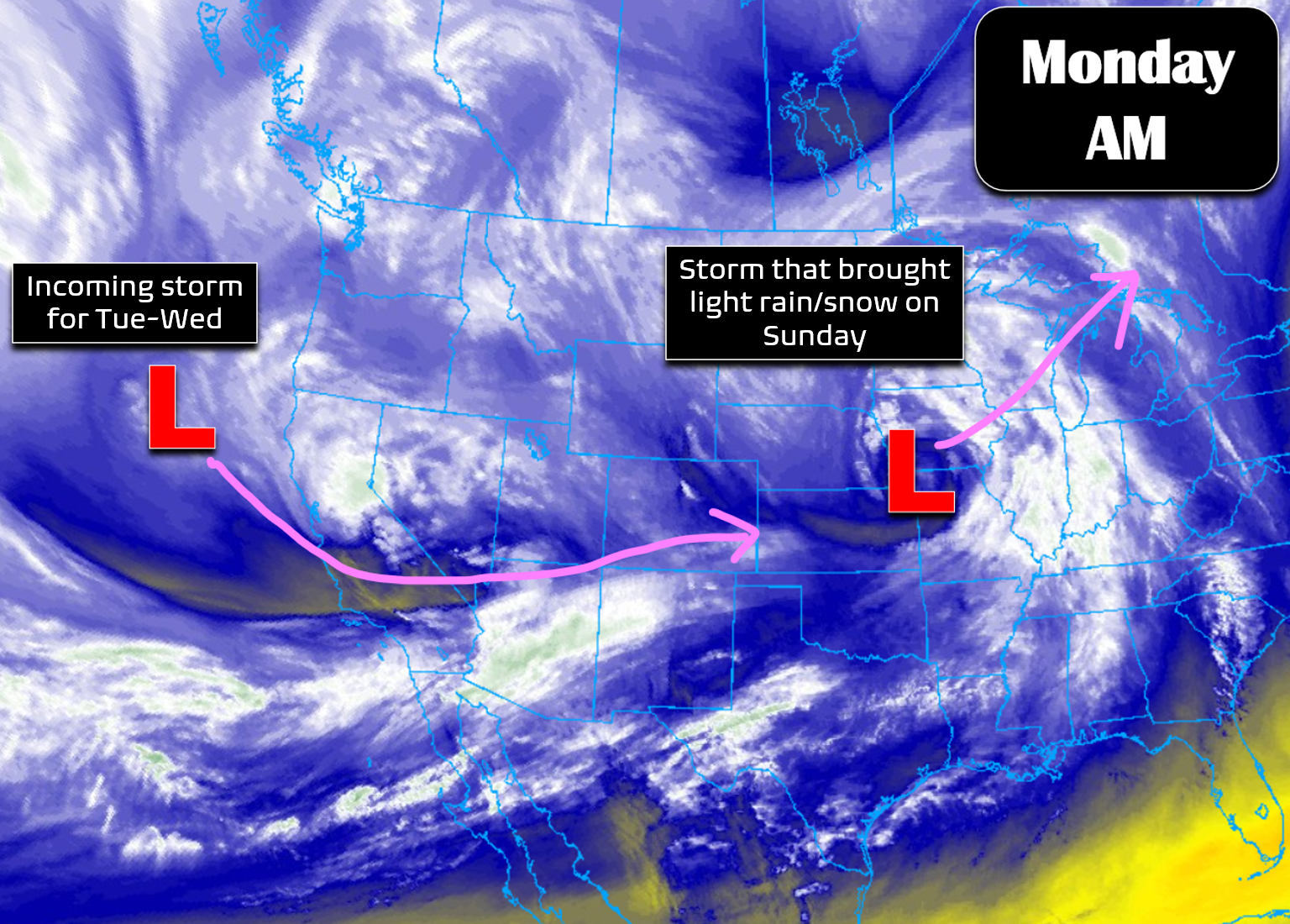
As one disturbance departs the area through the Midwest — the one that brought spotty rain/snow showers to the area Sunday — another approaches from the west over the Pacific with its eyes set on slamming eastern Colorado with a major snowstorm later in the week.
As a result of being between systems for the time being, Monday will be a pretty nice day across the Front Range with highs in the 40s under partly cloudy skies.
Major snowstorm coming to eastern Colorado
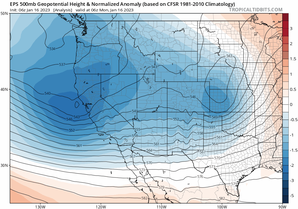
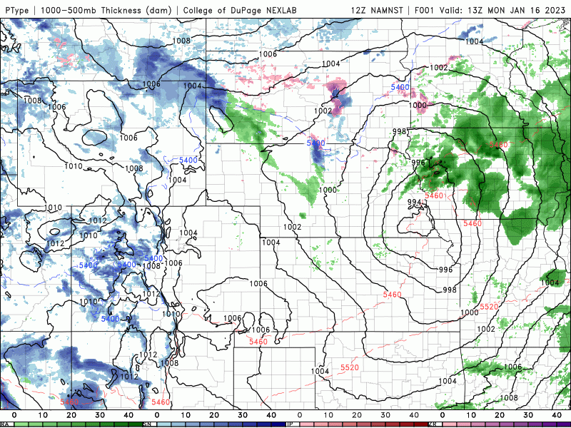
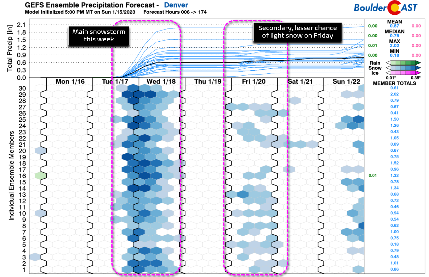
The main weather focus this week for us will be the significant snowstorm that is taking shape for our area late Tuesday into Wednesday as yet another Pacific trough marches in. The relentless Pacific storm track has been incredible the last four weeks — California has felt this moreso than Colorado — but we’ve had our fair share of rain/snow from it too! As of Monday morning, the storm we are closely monitoring is located just offshore from northern California. Over the next 48 hours it will slide southeastward and across the Four Corners area, eventually evolving into a strong closed-low in eastern Colorado by Wednesday morning.
Below is the latest European ensemble forecast showing the storm as it moves eastward and into position across eastern Colorado by Wednesday morning. While probably not digging quite far enough southward to be considered a true “Four Corners Low” in our book — having all the bells and whistles that would come with that — this system will still be an impactful one across the Mountains and northeast Colorado.
By late Tuesday evening, the GFS model has the mid-level low pressure taking shape across east-central Colorado with upslope flow beginning to intensify over northern Colorado and southern Wyoming. This is about the time we expect widespread snowfall to breakout across the area.
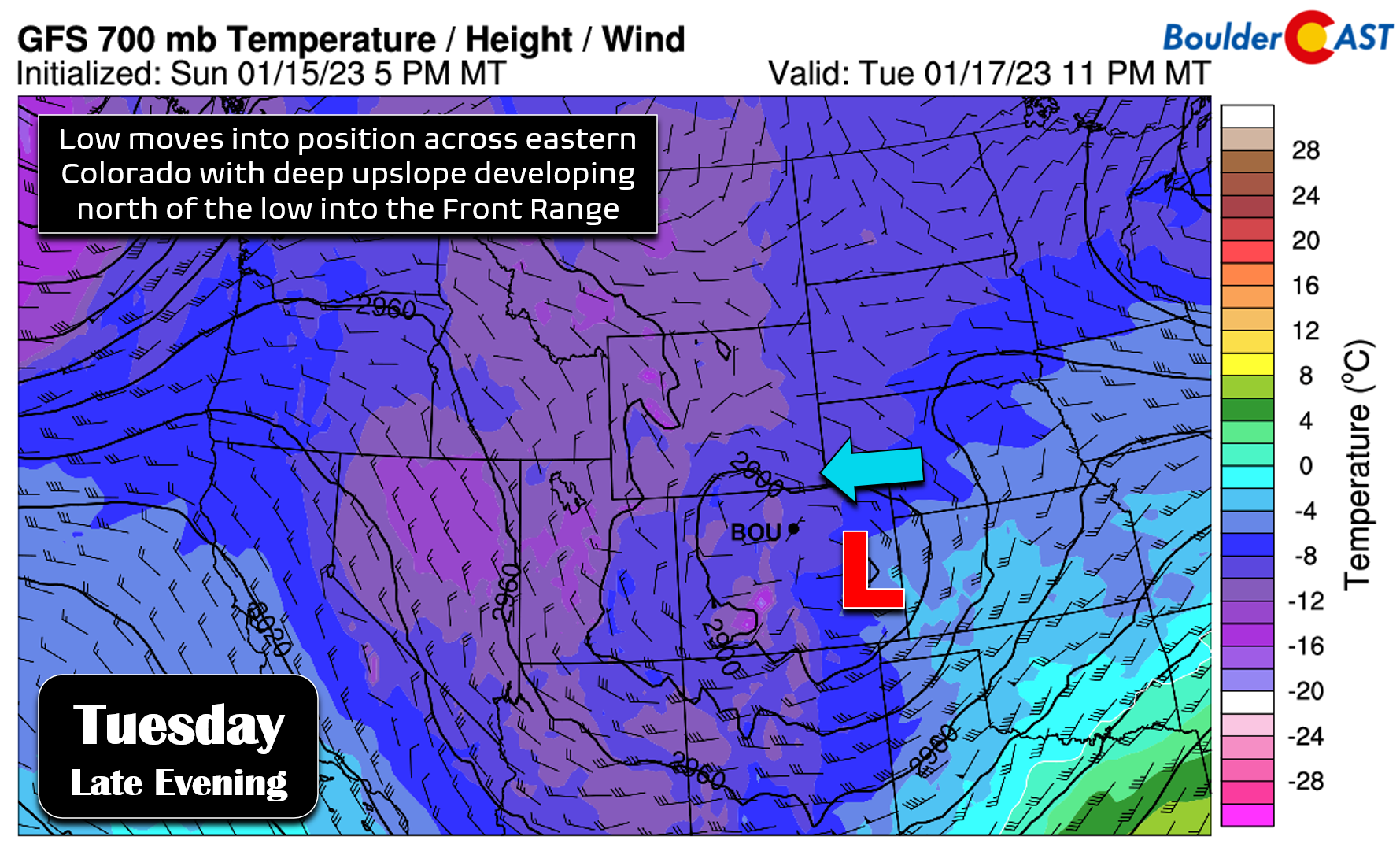
The low pressure will continue to intensify across the eastern plains of Colorado through the early morning hours Wednesday with wind speeds around the low ramping up. However, the upslope flow indicated for the Boulder-Denver area is rather muted, being very close to northerly during the peak of the storm. This is not good for maximizing the snow potential of this system. The most intense and longest duration of snowfall will likely occur in areas east of Interstate 25 as a result, out closer to where the surface low pressure will be located.
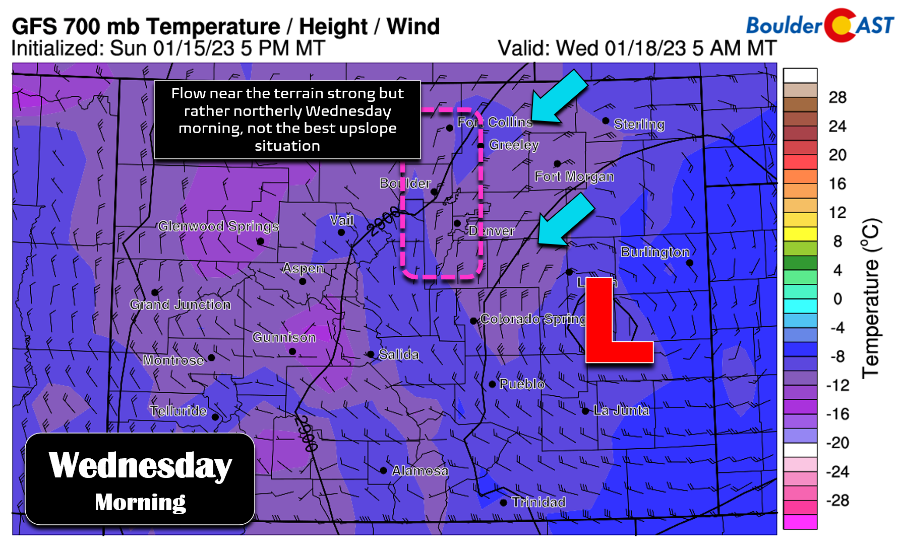
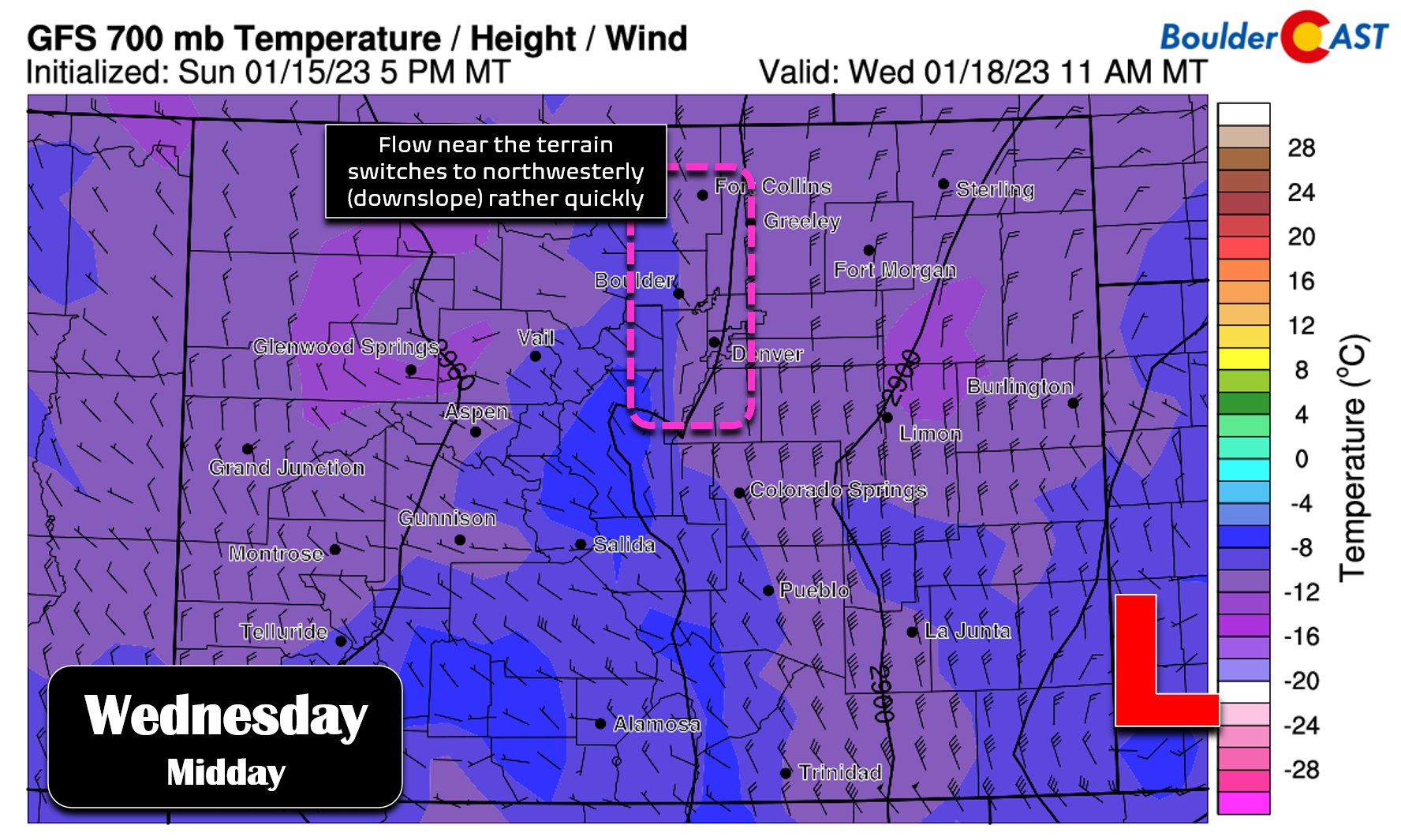
By midday Wednesday, signs are pointing to downslope already taking hold across the Boulder and Fort Collins areas. We are seeing this trend across a number of models right now. This downslope shift would begin to taper off snowfall in the Foothills and western Metro area.
The end result will be a somewhat southern-track winter storm that packs less upslope than we might expect given the track of the storm. Still, other factors will still be present with this event. The wrap-around deformation zone should clip our region for a few hours with heavy snow possible Wednesday morning. There will be at least a handful of hours with decent upslope before northerly flow and eventually downslope take over. Moisture will be decent, but not off the charts. This won’t be a particularly cold storm either — modest snow ratios between 10:1 and 12:1 are expected which will make the boom scenarios less likely to occur.
Snow amounts remain a bit tricky here given the lead time — snow won’t commence for another 36 hours after all with the end of the event some 60 hours away— but there is strong model support for everyone in the Front Range to pick up several inches of snow. Our Snowfall Probabilities are keenly leaning towards most of us seeing 4″ of snow or more. Due to the downslope shift and distance from the low pressure, the western Denver Metro, Boulder, and Foothills are least likely to exceed 6″ of snow.
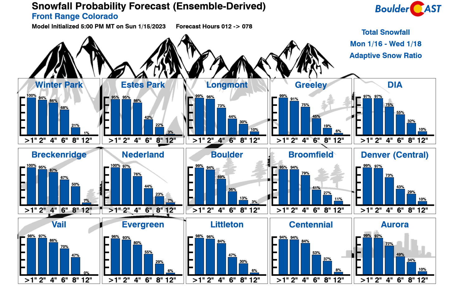
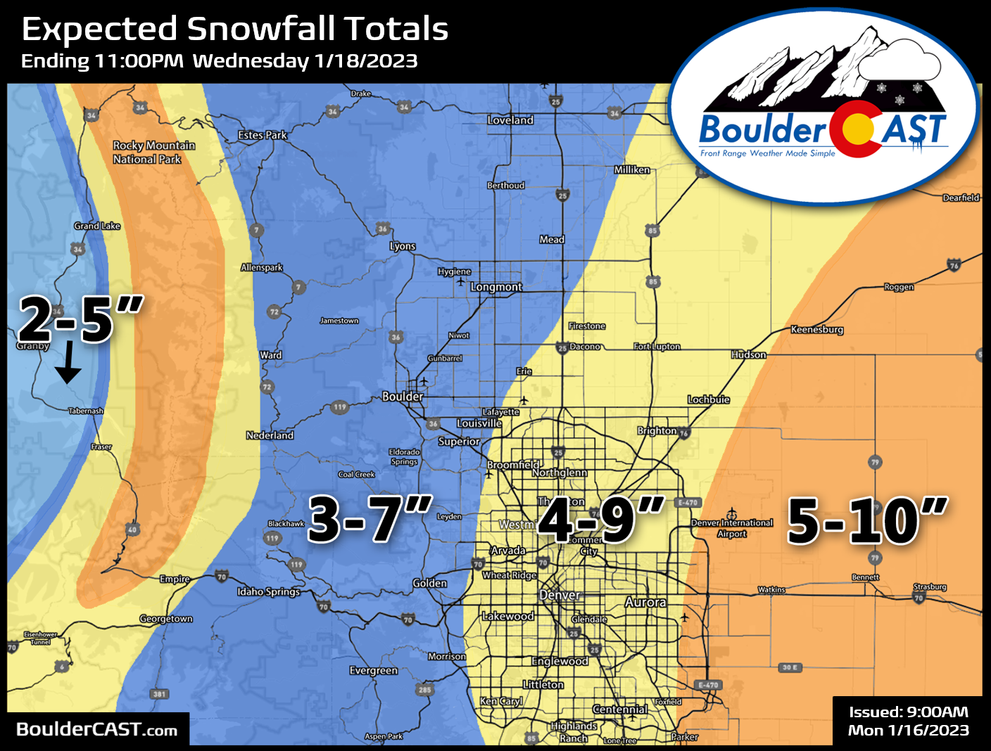
Our preliminary snowfall forecast map (emphasis on preliminary) for the event is shown below covering all snow falling through Wednesday evening. The highest totals will be in the eastern suburbs of Denver, the lowest totals around Boulder.
Tuesday will be generally quiet for us with highs cooler and in the upper 30s with a slight chance of late afternoon and evening snow showers as the storm arrives. The more widespread and intense snowfall will begin during the late evening Tuesday continuing through Wednesday morning. Current model trends have the heaviest snow potential for the Front Range between 10PM Tuesday night and 10AM Wednesday morning. The morning commute on Wednesday will be a snowy one — definitely plan for that! As the low pressure pulls away into Kansas by Wednesday afternoon, the snow will taper off from west to east across the area. Highs on Wednesday will be in the upper 20s.
Check back early Tuesday for another updated discussion on the storm, including a final update to our snowfall forecast map.
Another chance of snow late week
Thursday will be similar to Monday in that it will be quiet in between storm system with some sunshine but temperatures staying cold — lower 30s for highs.
We do have yet another chance of snow on our radar Thursday night through Friday. This is quite a ways out in the forecast, but models have been consistent in bringing another weak disturbance across southern Colorado late week with impacts ranging from minor to non-existent for the Denver Metro area. This one has been trending further south — perhaps too far south. Time will tell on this one, but this system should bring another wave of snow to the Mountains and a dusting or less to the Denver area. It will usher in a reinforcing cold front with highs likely plunging back into the 20s to end the work week.
Forecast Specifics:
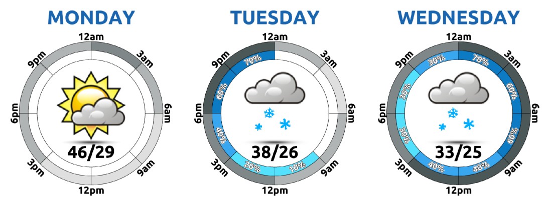
Monday: Partly to mostly cloudy and seasonal with highs in the middle 40s on the Plains and in the lower 30s in the Foothills.
Tuesday: Some morning sun possible, then increasing clouds with a slight chance of an afternoon and evening snow shower. The main winter storm holds off and begins in the late evening, with snow continuing through the overnight into Wednesday. Highs in the upper 30s on the Plains with upper 20s in the Foothills.
Wednesday: Cloudy with snow a sure bet during the morning, heaviest before noon. Use caution during the snowy morning commute. Snow tapers off from west to east through the afternoon hours. There could be some peaks of sun before sunset as well. Highs only in the upper 20s on the Plains with lower 20s in the Foothills.
Thursday: A chilly morning with some sunshine early, then increasing clouds and dry with a high around 30 degrees on the Plains and in the upper teens in the Foothills.
Friday: Staying cold with a slight chance of snow showers. Minimal to no snow accumulation is expected. Highs only in the 20s on the Plains with teens in the Foothills.
PowderCAST: The San Juans will be favored for more than 2 feet of snow this week, with lesser amounts for the central and northern Mountains of Colorado.
Help support our team of Front Range weather forecasters by joining BoulderCAST Premium. We talk Boulder and Denver weather every single day. Sign up now to get access to our daily forecast discussion email each morning, complete six-day skiing and hiking forecasts powered by machine learning, first-class access to all our Colorado-centric high-resolution weather graphics, bonus storm updates and much more! Or not, we just appreciate your readership!
Spread the word, share the BoulderCAST forecast!


You must be logged in to post a comment.