A nice warm-up occurred over the weekend following our first snow late last week. The forecast for Thanksgiving week will feature a series of low pressure systems tracking from west to east across Colorado, leading to a moderate dumping of snowfall in the High Country…great news for all you skiers! As for the Plains, our weather trends back to cooler conditions with a chance of snow tonight and on Thanksgiving. Continue reading for our complete weekly outlook.
Monday: cloudy and transition to rain/snow
The week starts off with a low pressure system moving through from Arizona. This system will bring a cold front across the Plains region late this afternoon and evening, while also bringing in the chance of rain/snow on the Plains overnight and tomorrow morning. Expect lots of cloud cover with the system moving in today, and cooler temperatures near 60 degrees.

GFS 500 mb absolute vorticity, showing the low pressure system moving in from Arizona.
Below is a close-up of the cold front today, with the blue line denoting the position of the front at 5PM. The front will continue to push south later night. Upper-level divergence from the low pressure system will increase moisture and with low-level upslope, we can expect rain showers on the Plains that will see light snow mix in after midnight and early Tuesday morning.
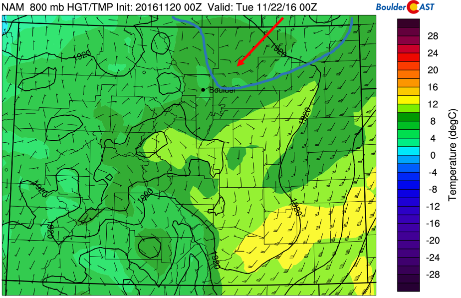
Cold Front as seen in the low-levels at 800 mb. Front shown in Blue with arrow denoting frontal movement.
Snow levels look to start out ~9,500 feet across the region, but by Tuesday morning, they will drop to support snow down to ~5,500 feet, with rain/snow or non-accumulating snow for most of the Plains.
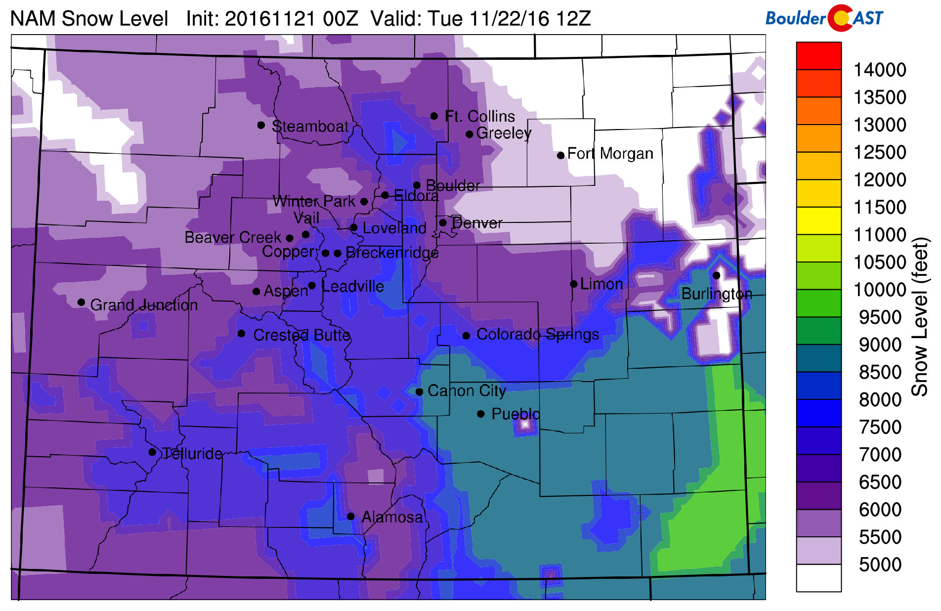
NAM model forecast snow levels for Tuesday morning
As for how much rain and snow we will get, the models are showing around 0.25″ of precipitation. The rain will likely begin after 6PM, with rain mixing with snow after midnight.

NAM total precipitation (left) and precipitation type for Monday night-Tuesday morning
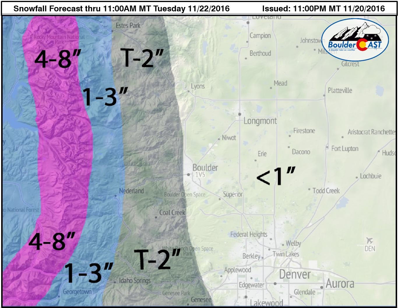
With the ground warm and wet, as well as surface temperatures staying above freezing, we are not expecting much accumulation. Most will be on grassy surfaces (if any at all). At most, expect up 1″ in some localized areas, with 1-4″ in the higher Foothills. Our snowfall forecast map for tonight is shown below:
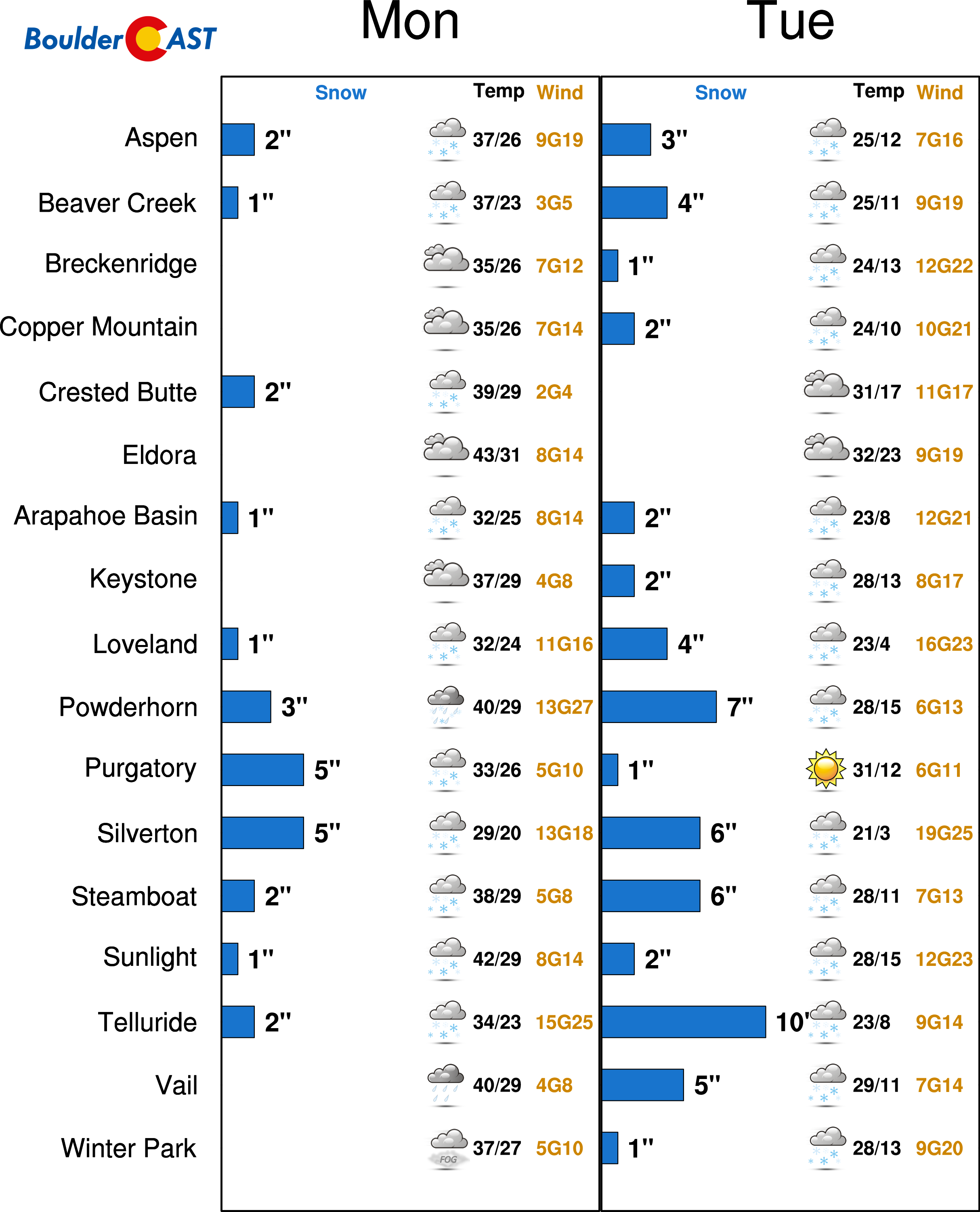
The High Country will see the BIGGEST benefits from this system today. A first wave brings snow to southwestern Colorado this afternoon and evening. A second wave brings widespread snow over the High Country tonight and during the day Tuesday. Here is a hint of the potential snow for the ski resorts with this system (focus on Monday and Tuesday). We would expect anywhere from 4-8 inches in the mountains. Remember to stay up to date with our PowderCAST page for the latest snow forecasts!
Tuesday: cold and cloudy
Tuesday is cold and cloudy. Below shows the low-level wind and temperature field, depicting temperatures below freezing in the afternoon, with a stiff northeasterly flow at 10-20 mph. With the cloudy conditions and potential snow on the ground to limit warming, highs will be much colder with temperatures having a hard time getting out of the lower 40’s. Bring your coat on Tuesday!
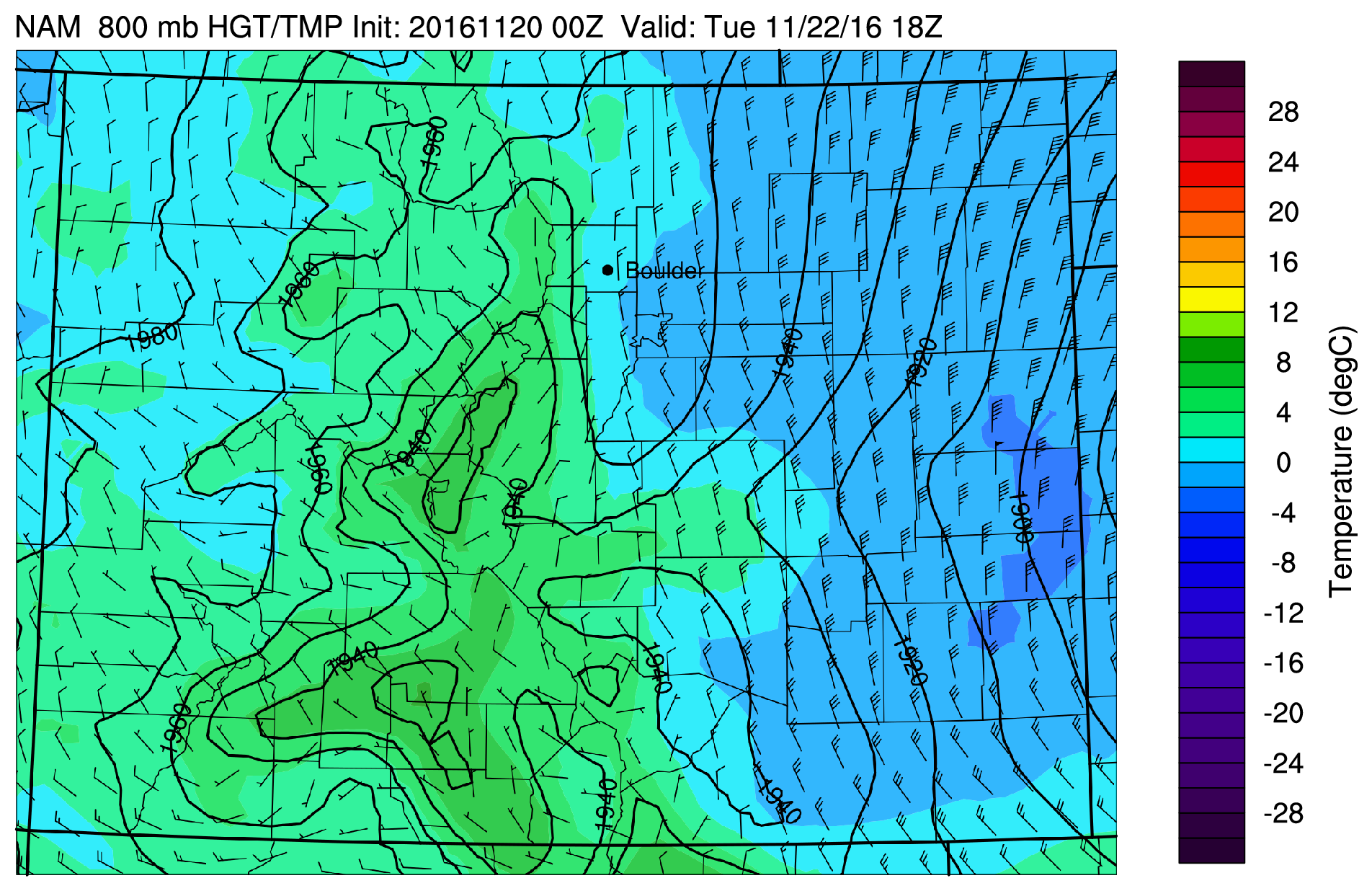
NAM 800 mb temperature and wind for Tuesday
Wednesday: tranquil and partly cloudy
Wednesday will be rather calm and sunshine will creep back in to the forecast. A brief ridge of high pressure centers itself right over Colorado. However, as is evident in the plot below, our next weather-maker is just moving onshore over California on this day. That will be a player for Thanksgiving. Highs Wednesday will be slightly warmer than Tuesday, with a mix of clouds and sunshine.
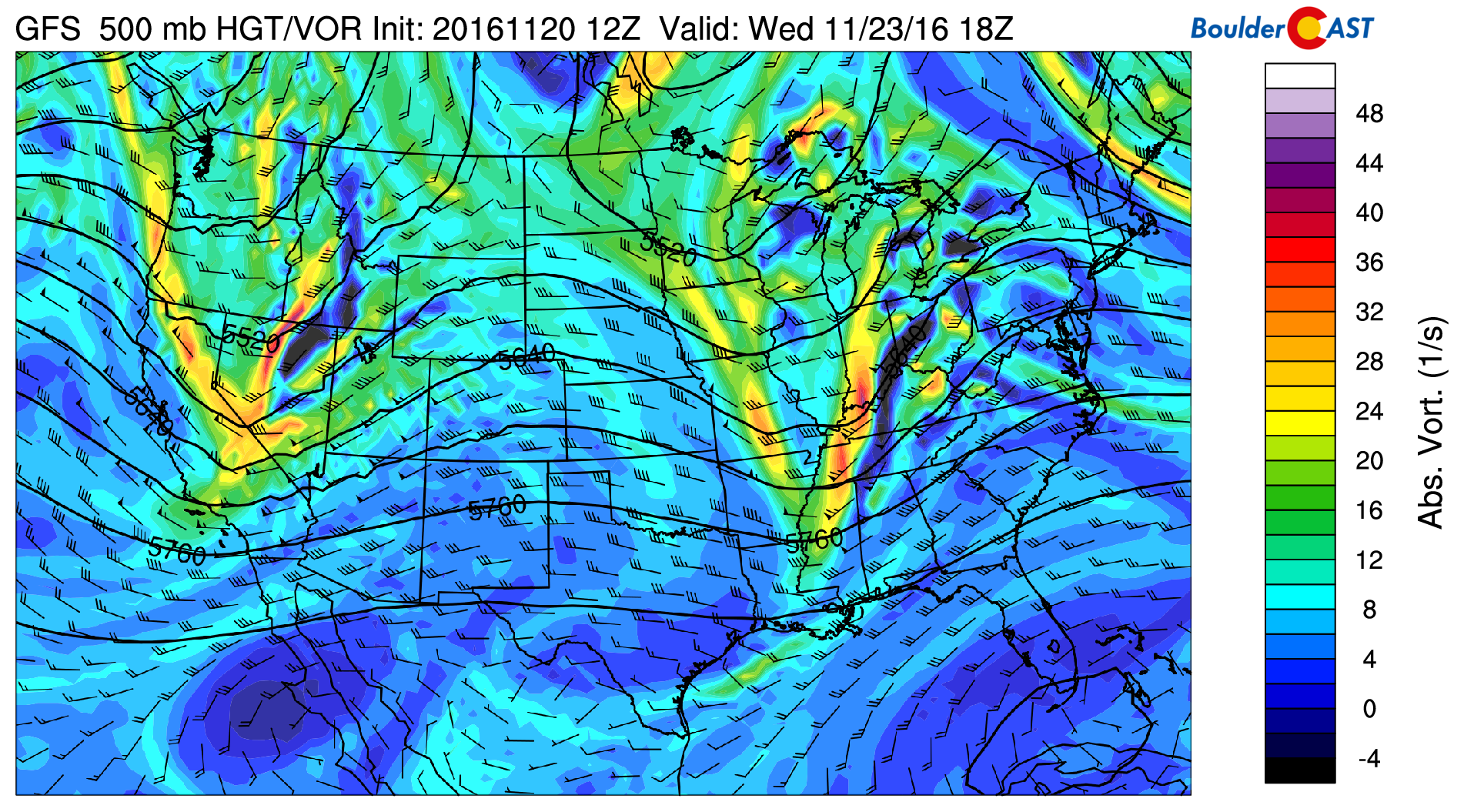
GFS 500 mb mid-level flow for Wednesday.
Thanksgiving Day: active, windy, and chilly
On Thursday, a very quick upper-level storm system mentioned above will race across Colorado during the morning and afternoon. Currently, many of the forecast models show this storm as a fast-mover, tracking primarily west to east, bringing downslope conditions for the Plains. All these indicators four days out say that this system will mainly be a snow-maker for the High Country. On the Plains, we are not expecting much. However, as we saw last week, if this storm tracks slower and shows a more southwest to northeast track for upslope conditions, the lower elevations could see snow on Thanksgiving. We’ll provide updates, if necessary, as we get closer to the event…
As mentioned, the ski resorts and Mountains will see the most benefit. We would not be surprised if areas above 10,000 feet with western exposire pick up another 3-6″ on Thanksgiving. If you’re going skiing on Thursday, it will be a nice treat.
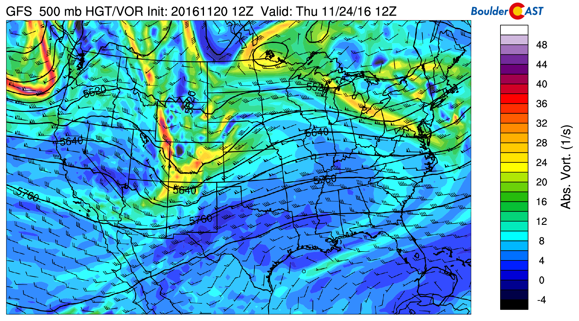
GFS 500 mid-level flow on Thanksgiving day, showing the strong storm system.
If you’re staying in Boulder or Denver on Thursday, you will want to dress warm and be prepared for potential gusty winds in the afternoon from the northwest. The latest GFS model is indicating low-level winds from the northwest at 40-50 mph. Although we are 4 days out, Thanksgiving on the Plains could be quite gusty if these downslope winds verify. If the storm tracks further south and moves slower, all bets are off. Temperatures remain in the middle to upper 40’s in Denver.
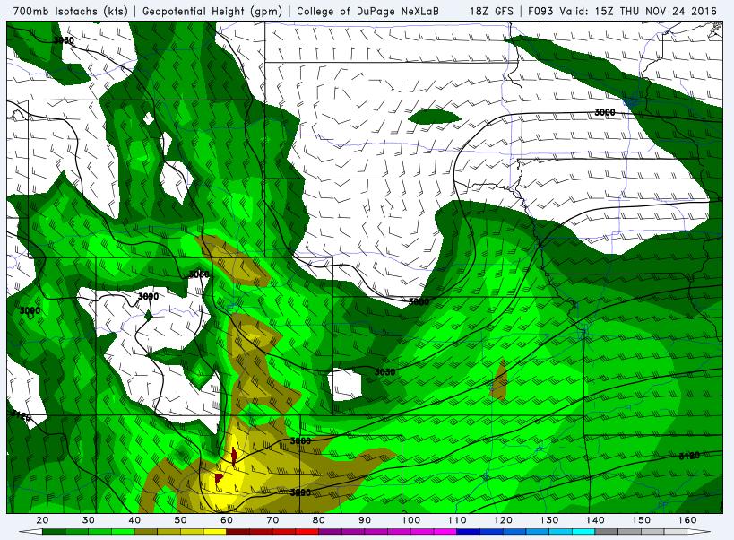
GFS 700 mb wind field for Thursday, showing northwest winds for the Plains potentially up to 50 mph. Image courtesy of College of DuPage
Black Friday is cool but calm
After Thanksgiving is the annual rush to start your Christmas shopping! What does the forecast look like? Well, it shows a zonal flow with a weak ridge of high pressure setting up to end the week. That should allow temperatures to moderate to seasonal levels in the lower 50’s with sunshine.
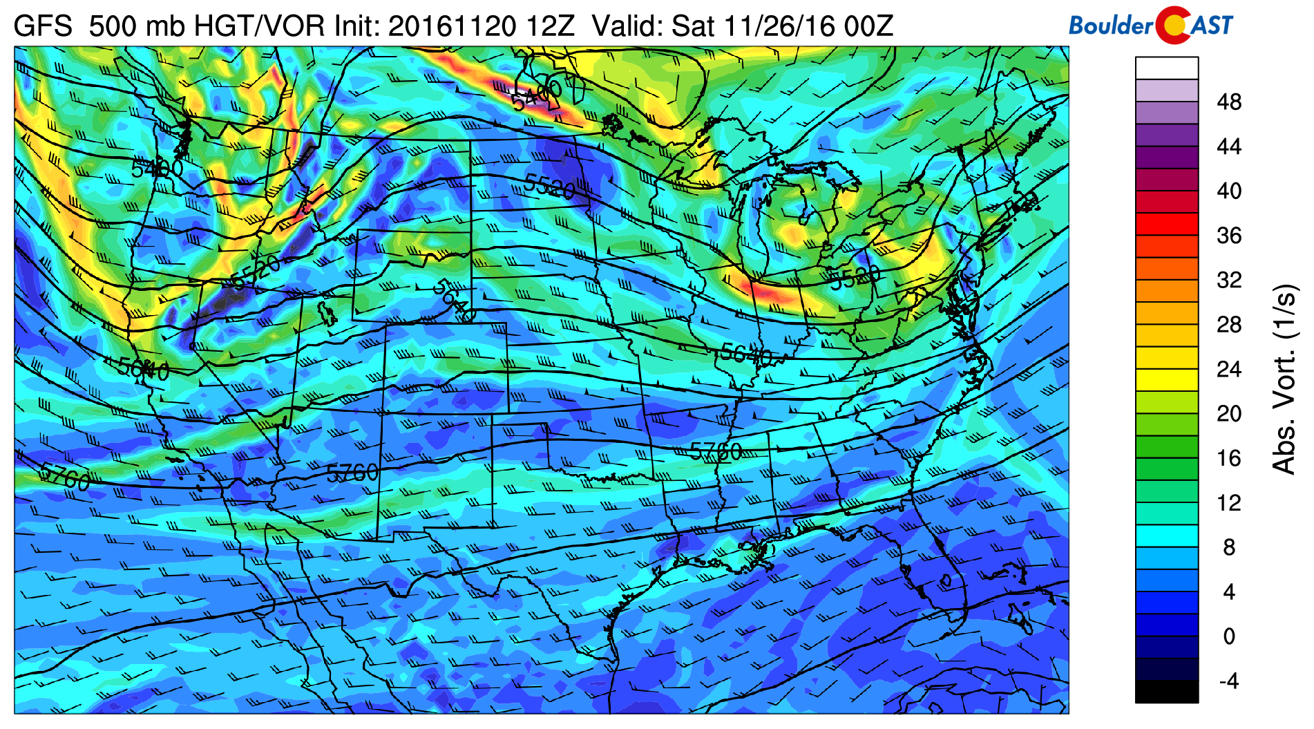
GFS 500 mb mid-level flow on Friday.
Extended outlook is active with Mountain snow
The extended forecast over the holiday weekend and into next week is looking more active. Both the Euro and GFS forecast models are indicating that the upper-level jet stream will sag southward into southern California and extend eastward to encompass much of the western United States. Below shows the jet stream Saturday night into Sunday. Another round of Mountain snow can be expected over the weekend. Next week, this jet stream should remain active. This all points to snow finally starting to actually accumulate in the High Country; great news for skiers! As for the Plains, while the pattern looks to get active, the devil is in the details, and its difficult to nail down any specifics for next week and beyond, but its possible another snow storm could move in by the beginning of December.
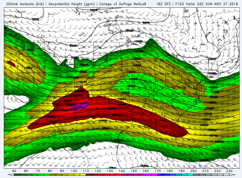
GFS 250 mb wind speeds and height pattern over the holiday weekend. Image courtesy of College of DuPage
That’s all for now… From all of us at BoulderCAST, have a blessed and wonderful Thanksgiving!
Forecast Specifics:
Monday: Mostly cloudy with temperatures near 60 over the Plains and upper 40’s in the Foothills. On Monday night, expect rain showers, changing to light snow showers after midnight and early Tuesday morning. Total snow accumulation of at most 1″, with many areas seeing less, mostly on grassy surfaces and cars. In the Foothills above 6,500 feet, 1-4″ is possible.
Tuesday: Spotty light rain/snow showers lingering in the morning. Cold and cloudy with breezy northeasterly winds. High temperatures in the lower to middle 40’s in Denver. Temperatures in the lower 30’s in the Foothills.
Wednesday: Cloudy skies in the morning giving way to afternoon sunshine and temperatures warmer in the upper 40’s to 50 degrees on the Plains and middle 30’s in the Foothills.
Thursday: Windy and chilly. Highs in the mid to upper 40’s on the Plains under a mix of clouds and sunshine. Northwest winds may gust up to 50 mph in the morning and early afternoon. Windy with light snow in the Foothills with temperatures in the low 30’s.
Friday: Partly cloudy and warmer with temperatures in the low 50’s on the Plains and lower 40’s in the Foothills.
High Country: It’s all about snow for the Mountains. Expect anywhere from 4 to 8 inches Monday into Tuesday over much of the state, with some spots seeing 10″. Another round comes Thursday with 3 to 6 inches possible, with northern Colorado’s resorts being favored during this second storm.
Extended: After a tranquil day following Thanksgiving, the pattern looks to be quite active over the weekend and next week to close out November and begin December. The High Country will likely see more snow over the weekend and early next week. As for the Plains, the forecast is less certain, depending on the exact position of the jet stream and accompanying low pressure systems. Think snow, everyone!
Mon
Tue
Wed
Thu
Fri


Temperature
62
45
49
47
52


Precip Chc (Plains)
50%(pm)
40%(am)
0%
0%
0%



You must be logged in to post a comment.