We hope you all had a great holiday to close out the year. Our weather has remained cold, but at least fairly sunny over the last week or so. For the first full week of 2016, the main story will be the arrival of frequent but weak weather systems along the California coastline, each a little more potent than the prior. By the time they arrive in eastern Colorado, they will stripped of most of their moisture and energy, but we may be able to squeeze a few flakes out, even on the Plains. Read on for the details.
Right on cue, as we mentioned in our last forecast, the storm track has taken that southward dive.
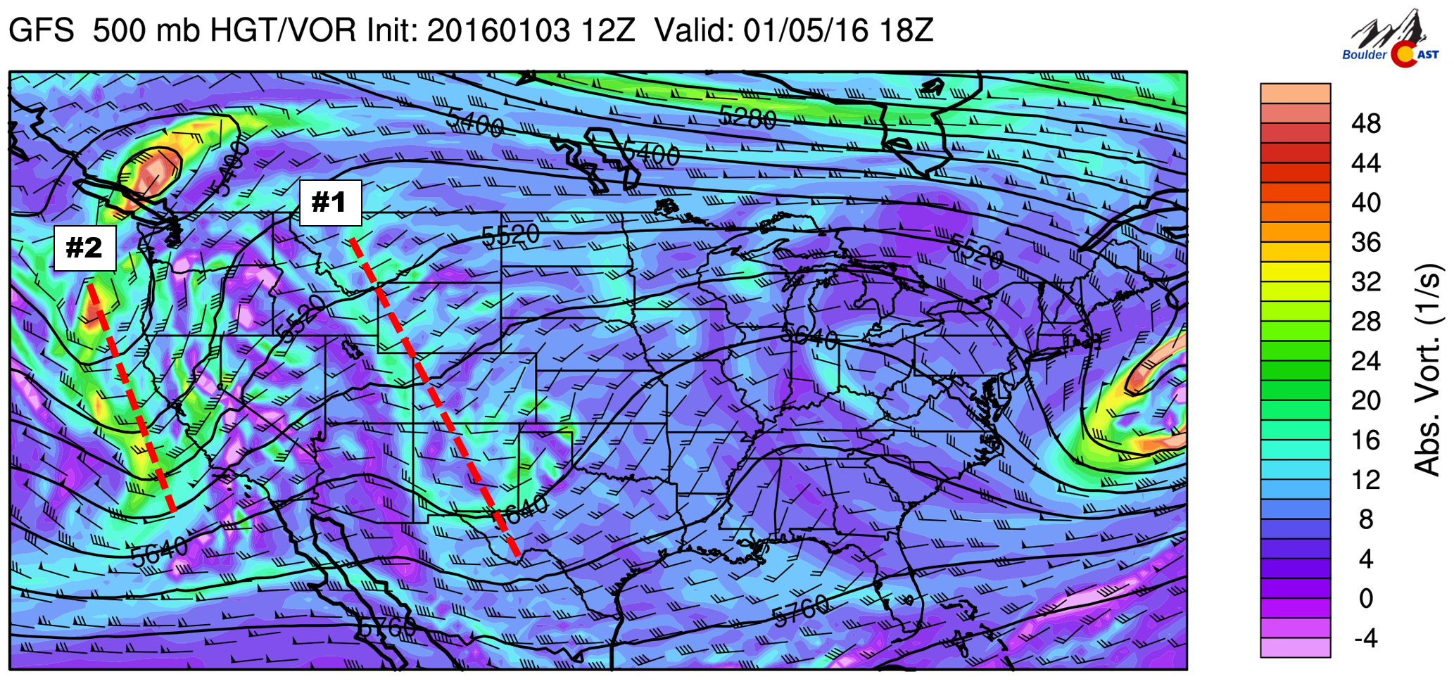
The first wave has just come ashore this morning and can be seen below, with the positively-titled trough axis dashed in red.
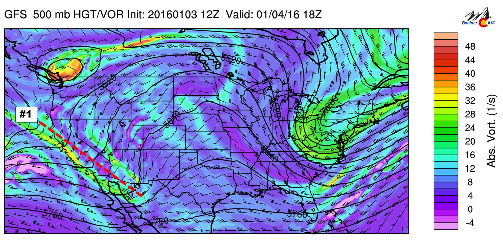
GFS 500mb vorticity map for Monday afternoon, showing the arrival of the first storm system this week.
At the same time, you can see Colorado is under a ridge today, with weak southwesterly flow aloft. Dry flow and large-scale subsidence will keep us all sunny (save some high clouds) and dry this afternoon, with temperatures on the Plains in the 40’s.
Tomorrow, that first piece of energy moves over the state. It remains very weak, but snow will be possible in the mountains of western Colorado favored by southwesterly flow (the San Juans). Across eastern Colorado, things will stay somewhat sunny and warm (low 50’s!). High clouds will fill the sky through the day. Concurrently, a second piece of energy arrives to California (see below).
By Wednesday, Colorado rests comfortably between the first and second pieces of energy, within a shortwave ridge.
This set-up will continue to bring snow to southwest Colorado, with mostly dry conditions remaining across the Front Range. Some very light isolated snow showers may be possible in our Mountains Wednesday during the day.
Our weather will become more interesting on Thursday as a third trough merges with #2. A weak surface low is projected to develop in southeastern Colorado (see below), which will swing a cold front down across the Plains during the morning. Increased cloud cover, upslope, and cold air advection will knock temperatures back down into the 30’s for Thursday afternoon (and Friday).
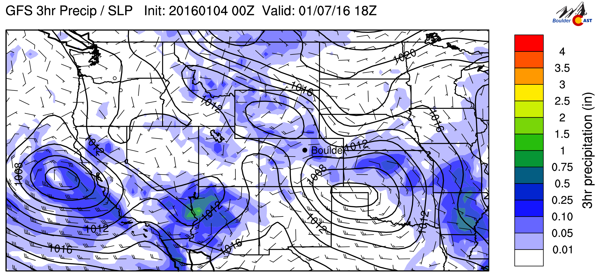
GFS precipitation and sea-level pressure forecast for Thursday afternoon, showing a developing surface low in the Oklahoma Panhandle.
Snow showers will likely increase in coverage across the Mountains late Wednesday night, with some precipitation finally spreading on the Plains by Thursday morning. Temperatures should be cold enough for snow throughout, but we aren’t expecting anything significant for the Denver Metro area at this time. The “heavier” snow will likely be confined to the area near the surface low (probably western Kansas).
It is important to note that models are having trouble coming into agreement on exactly where the low will develop and how long it may stick around. The GFS and NAM somewhat similar (as seen in the image above), while the Canadian brings the low further south, but has snow lingering into Saturday for the Front Range. We think the GFS solution is the most plausible, but it’s really just splitting hairs at this point. The difference would likely have implications between Boulder picking up an inch or two, or just a few flurries.
Some Front Range Mountains could be in the neighborhood of 6″ by Saturday, but the bulk of the snow will be confined to western Colorado (which will see 1 to 2 feet in places, with Winter Storm Warnings likely around Telluride). The GFS snowfall map through Saturday is shown below.
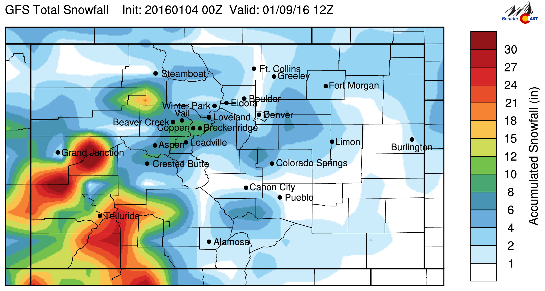
GFS total snowfall forecast through Saturday morning. If anything, it indicates at least the potential for some of the Front Range to pick up some light snow Thursday into Friday.
Friday will see the chance of light snow remain across the region, particularly in and near the Foothills with weak upslope in place. We don’t see much potential for accumulation greater than 2″ for the Plains, but there is plenty of time for things to evolve. Check back later in the week for updates. For now, Friday looks cloudy, cold (highs near 30 degrees), with a slight chance of light snow, especially in the first half of the day.
As we suggested earlier, the headline this week is the repeated pummeling of coastal California, storm after storm. Great news for the drought there, as long as it doesn’t come too heavily. The GFS precipitation forecast through Saturday is below, indicating a large portion of the state is likely to see greater than 1″ of rain (and heavy mountain snow in the Sierras).

GFS total precipitation forecast through Saturday morning, showing heavy precipitation across California, with a “rain shadow” just east of the Rockies.
Have a good week! Oh, and in case you missed it, be sure to check out our recap post summarizing all of the crazy weather Boulder experienced in 2015!
The Forecast:
Monday: Partly sunny. Highs in the mid 40’s across the Plains, with upper 30’s in the Foothills.
Tuesday: Partly sunny and mild. Highs in the low 50’s on the Plains, with mid 40’s in the Foothills.
Wednesday: Partly sunny. Highs in the upper 40’s on the Plains, with low 40’s in the Foothills.
Thursday: Mostly cloudy skies with snow beginning in the Mountains before sunrise, with a chance of flurries/light snow on the Plains come late morning and continuing into Friday. Highs in the upper 30’s on the Plains, with low 30’s in the Foothills.
Friday: Cloudy and cold with a slight chance of snow in the morning. Temperatures in the low 30’s on the Plains, with mid 20’s in the Foothills.
High Country Forecast: Dry across the Front Range until late Wednesday. Light snow will begin and linger into Friday with light accumulations (6″ or so).
Extended Outlook: Drier weather for the weekend (but mostly cloudy), with the active southern storm track continuing into early next week. This means plenty of storm activity in California, but limited moisture for eastern Colorado.
Source
Mon
Tue
Wed
Thu
Fri


BoulderCAST
43
49
46
38
33


NWS
44
48
45
35
32


AccuWeather
45
48
45
39
33


The Weather Channel
42
48
43
39
33
Last week’s recap:
Here are the results of last week’s forecast. First, the forecasts and observations from all of the sources:
Last week was characterized by the lingering cold air, with highs in the 20’s and 30’s. We didn’t have any chance of snow in the forecast, which did verify (except for a couple flurries that fell Thursday AM).
Let’s look at the error analysis. Shown below is the amount of degrees (in Fahrenheit) that each source was off from the mean observed temperature for Boulder. Positive values indicate the forecast was warmer than what actually occurred, while negative values arise from a forecast that was cooler than what was observed.
The worst forecast day of the week was Friday, with more than 6 degrees of error averaged across the board. Temperatures warmed to 38 degrees (above the forecast of 32). The rebound from the cold week was a little stronger than models were picking up on. But alas, we expect Friday (the fifth day out) to have the biggest error. It’s nice when that actually happens!
The bottom row of the error table shows the weekly mean error for each weather outlet, a good measure for who was the best and more consistent “forecaster” for the week. AccuWeather wins this week, with 2.2 degrees of error averaged across the week. BouderCAST comes up short, with a respectable 2.5 degrees of error, having the best forecast on Wednesday and Thursday. The NWS remains in last, with 3.5 degrees of error.




You must be logged in to post a comment.