Things are about to get interesting for Colorado as our weather finally starts to take a turn away from never-ending summer. The weekend ahead will see the polar jet stream dip southward with strong winds and bouts of Mountain snow. The main event, however, will arrive Tuesday into Wednesday of next week when the atmosphere could align to produce the first snow of the season for many Front Range locations. While uncertainty is still quite high with the incoming winter storm, we discuss the latest forecast details and what to expect heading into next week.
Key Highlights from This Post:
- First up: A windy and somewhat snowy weekend is in the works for the Mountains, with gusty winds and a slight chance of rain across the Plains
- Then, a secondary stronger and colder low pressure system will slam the central and northern Rockies Tuesday into Wednesday of next week
- Models have been consistent with this storm’s existence, but the finer details of the track will be crucial for determining the eventual impacts across the Front Range
- Boulder and Denver are favored to see some snowflakes from this system, but it is far from guaranteed
- A morning or two of frost will likely will follow the winter storm, with a slight chance of a hard freeze
Help support our team of Front Range weather bloggers by joining BoulderCAST Premium. We talk Boulder and Denver weather every single day. Sign up now to get access to our daily forecast discussions each morning, complete six-day skiing and hiking forecasts powered by machine learning, first-class access to all our Colorado-centric high-resolution weather graphics, bonus storm updates and much more! Or not, we just appreciate your readership!

An unsettled weekend, but not too bad
The weekend ahead will be fairly unsettled in Colorado as a large trough with several smaller embedded disturbances moves across the state. This particular trough is forecast to split with most of the energy either going north into Wyoming or south across New Mexico. As you can imagine, this isn’t great news for the Centennial State in terms of rain and/or snow output.

NAM-NEST 500mb height and vorticity forecast animation for Friday into Sunday afternoon showing the approaching trough and the embedded waves which split to go around Colorado
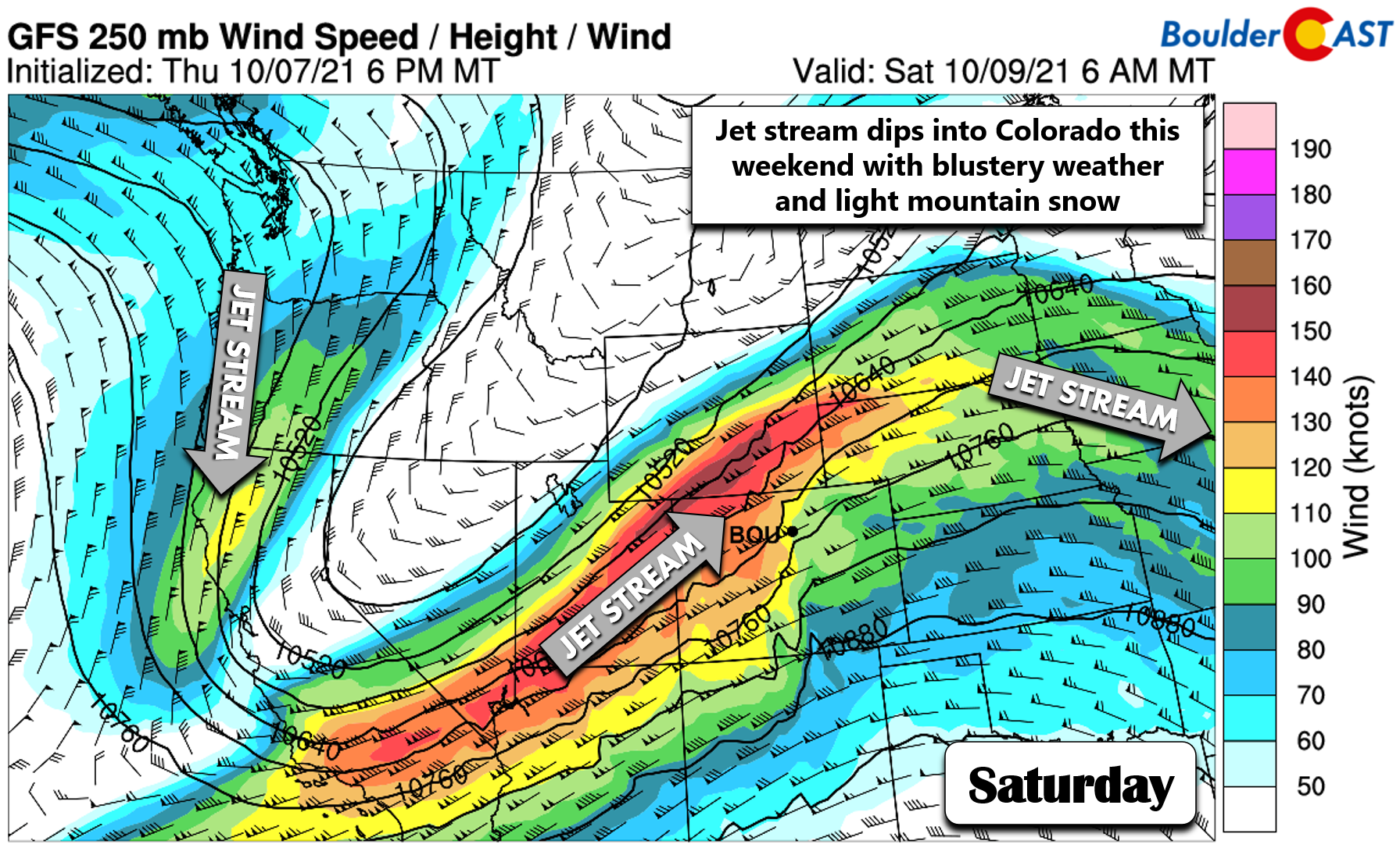
While there will certainly be notable changes in our weather compared to recent times, including some snow in the Mountains Friday night through Saturday, the main concern with this trough passage will be the strong winds as the polar jet stream dips into Colorado for the first time this autumn. The core of the overhead jet will reach 160+ MPH by Saturday morning (shown below). The high mountains should expect gusts of 35 to 60 MPH much of the day Friday and Saturday statewide before things calm down for the back half of the weekend. With some snow thrown into the mix, travel over the passes will become challenging at times. Keep that in mind if you’re heading up into the High Country the next couple days.
This near-term weather pattern is not favorable for precipitation east of the Continental Divide, however, with downslope flow expected much of the weekend. There is a slight risk of a few rain showers Friday afternoon and evening, with that slight chance then extending through the day Saturday as well with weak jet-forcing draped across northern Colorado. Despite temperatures staying above normal for us, potent west winds will be the story during the day Saturday across the Denver Metro area with gusts from 20 to 35 MPH. A good amount of leaves will come down on Saturday, so get your rakes and blowers ready!
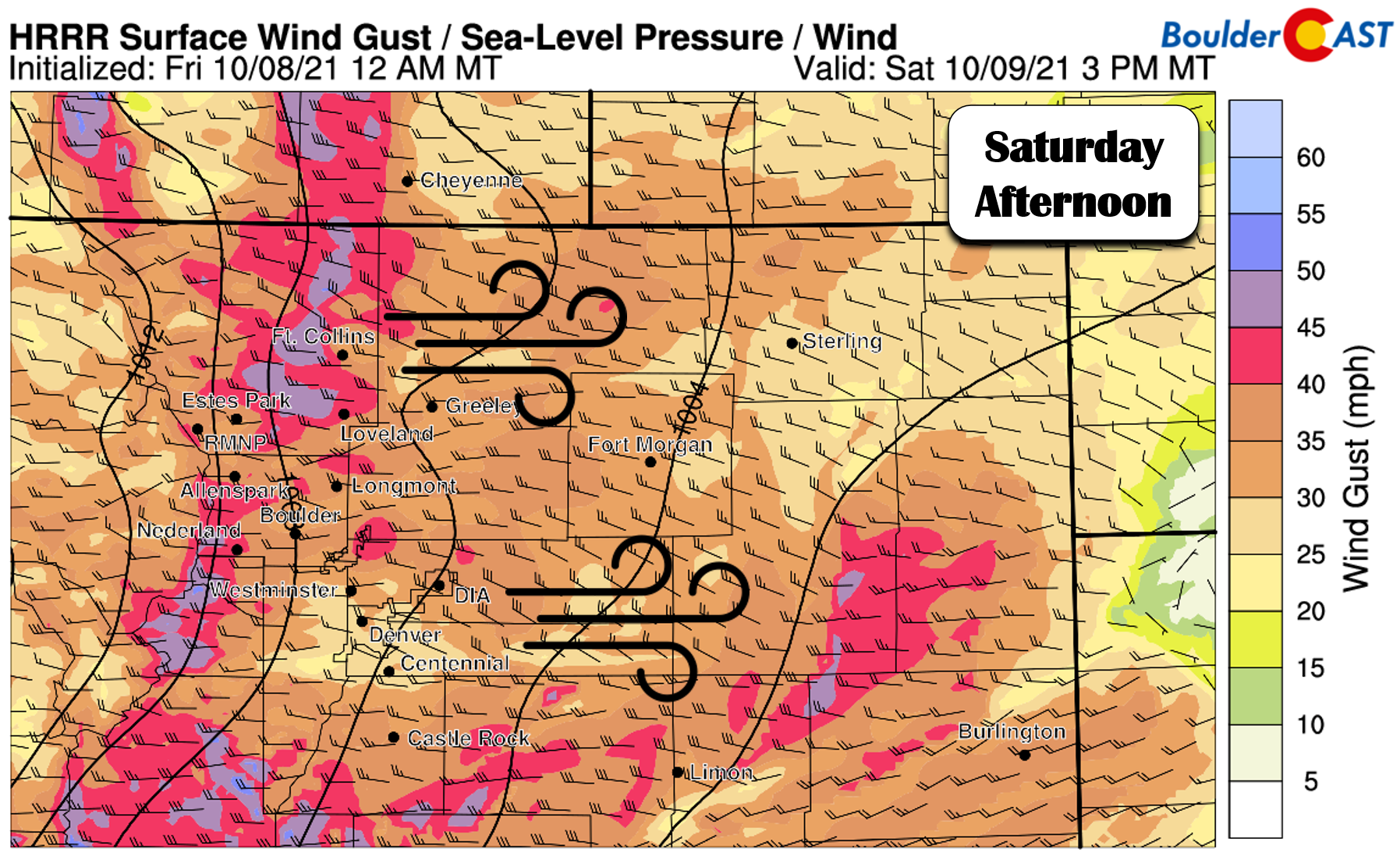
Gusty west winds are forecast Saturday!
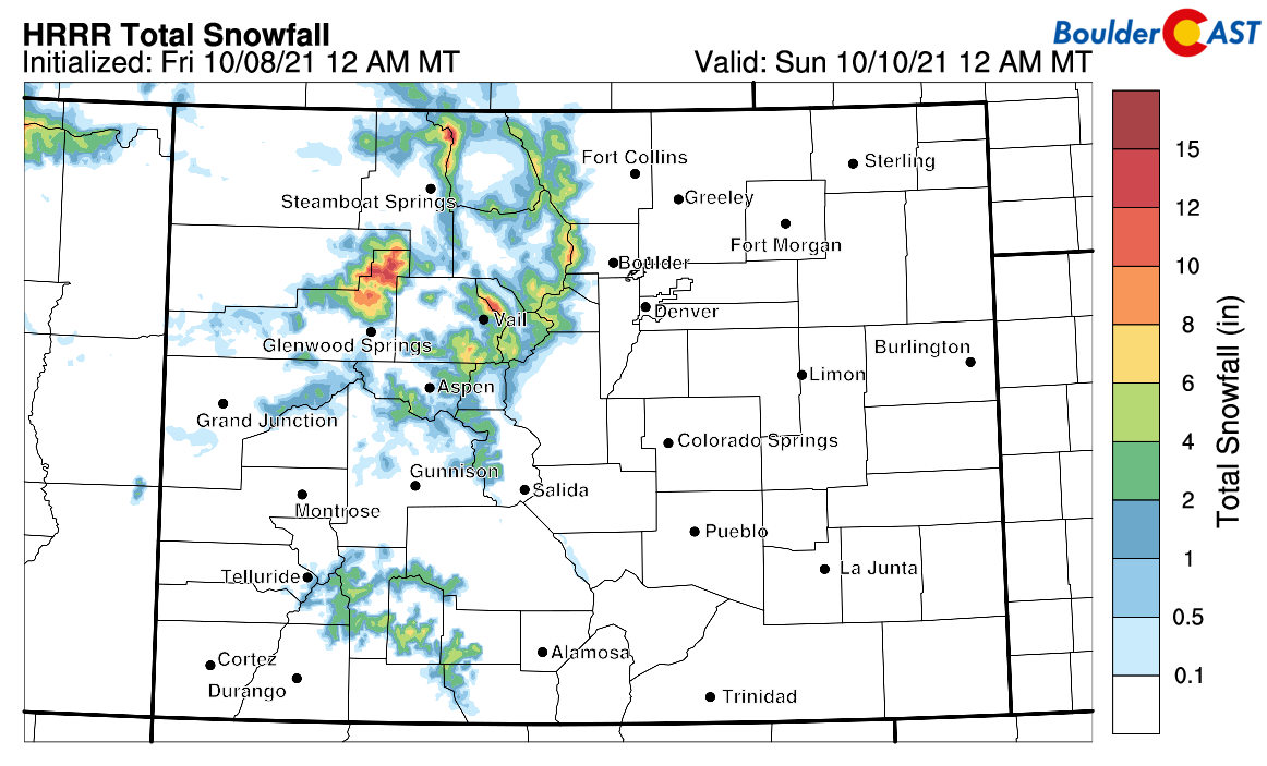
Here’s a look at projected snow totals through Saturday from one high-resolution model. Areas above 10,000 feet elevation will see 1 to 5″ of orographic and jet-forced snowfall from this trough passage, with locally up to 9″ possible.
Sunday will be drier and less windy statewide, but cooler overall following the passage of a weak cold front. Highs on Sunday will be in the 60’s in Boulder.
Tracking the first snow of the season next week
We’ve been talking about the threat of snow on the horizon for several days now in our morning forecast discussions. While initially we were very skeptical of what the weather models were advertising, the resulting outcome has changed little over the last three days with a significant early-season winter storm on-track to slam the Rockies next week. Exactly which part of the Rockies is still up for debate…
Overall model consistency with this storm has been excellent so far, which gives us confidence that there won’t be any major shifts in the general forecast for the western United States between now and the middle of next week. However, the main struggle we’ve seen in the models so far lies in the exact track, which this time of year (and any time of year really) is a crucial point of the forecast. We’ve seen the models waver back and forth between…
- a more northern track which would favor Wyoming for heavy snow, moderate snow in northern Colorado’s mountains, and almost nothing but downslope around Denver
- a slightly more southern one which would spread heavier snow into northern Colorado’s Mountains and higher Foothills and even light snow across the Denver Metro area
At this point, most models do agree on the positioning of a strong cut-off low pressure setting up near Las Vegas early Tuesday morning. However, model solutions diverge from there. As has been the case for the last few days, the European weather model has largely latched onto the northern track. As you can see below, the Euro has the storm moving almost directly over Cheyenne by Wednesday morning. With counter-clockwise flow around the storm, you can imagine how this track would produce mostly westerly downslope wind to the Front Range. Not good at all for snow in our area…

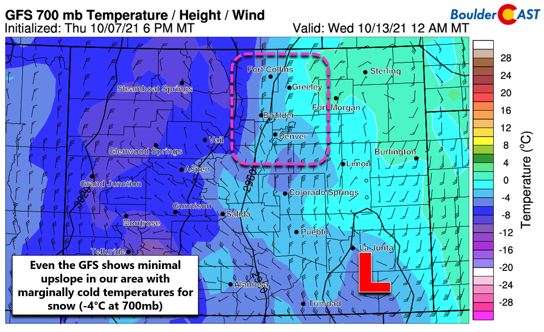
On the other hand, the American GFS model has fairly consistently shown a track further south for the storm, one which would allow colder air and upslope to develop in the Denver Metro area. The GFS has the storm moving across southern Colorado Tuesday night and ending up in western Kansas by early Wednesday. This is a decent track for snow in the Front Range…that is, if temperatures cooperate.

Even with the more favorable track of the GFS, upslope is not guaranteed across our area. The graphic below shows temperatures and winds near the 10,000-foot elevation level Tuesday night as forecast by the GFS. Generally northerly winds are present over our area, a direction that favors locales south of Denver for upslope but nowhere else. The GFS also has temperatures at this level bottoming out around -4°C. This is very marginal for snow on the Plains. Temperatures at ground level would be in the mid 30s, with rain possibly mixing to wet snow. Accumulation more than a coating would be challenging in this scenario.
For reference, here is what the latest runs of the GFS and Euro models are predicting for snowfall totals through Wednesday. As you can see, this particular GFS run does produce light snow in the Denver area (less than 1″), with several inches predicted along the Palmer Divide which would be colder and more favored by northerly winds. The Euro model’s downslope-inducing track produces almost no snow east of the Mountains.
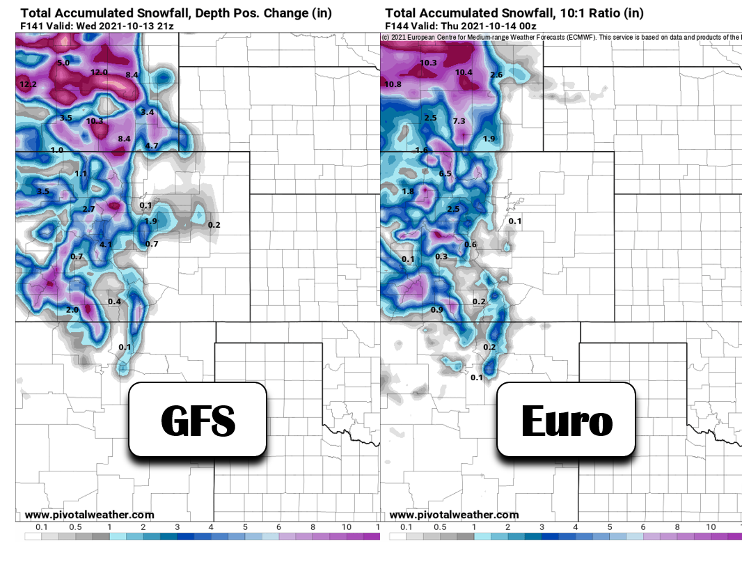
Total snowfall forecast through Wednesday of next week from the GFS and Euro models
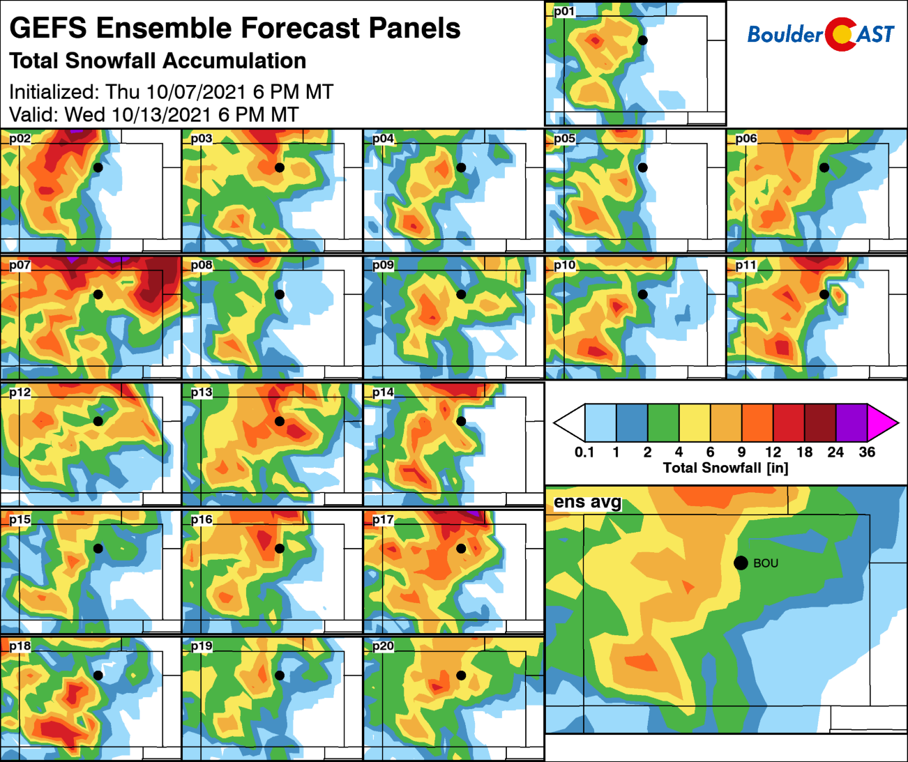
So which forecast is correct? Unfortunately, we don’t know yet as this storm system is still more than four days from reaching Denver and Boulder. One way we can help gauge the uncertainty with any winter storm is to look at the model ensembles. Ensembles are just repeated runs of the same model with slightly different initial conditions. On average, they are collectively more accurate than any individual run and the spread in the results gives us an idea about the range of potential outcomes. The graphic below shows the precipitation type and amount forecast from 30 GFS ensemble member runs. About 50% of the runs are showing snow in Boulder, including a handful with more than 4″ of snow (!). The spread is still uncomfortably high indicating an overall uncertain forecast. For reference, the ensemble mean is around 2″, while the ensemble median is less than 1″.

It’s still too early to throw out definitive predictions for this storm, but here are some of our initial thoughts:
- It’s unlikely the Boulder/Denver will get completely skunked from this storm. Even if it doesn’t snow, we should see at least scattered cold rain showers and some wind as the system passes either to our north or south.
- Mountain snow is all but guaranteed, possibly more than a foot in some ranges of across central and northern Colorado. At minimum, there should also be several inches of spillover snow along Peak to Peak Highway in the Foothills.
- Given the ensemble support from both the GFS and Euro and continued model consistency for snow across the Denver Metro area, we’d say it’s close to 50/50 whether accumulating snowfall occurs across the lower elevations. Chances are a bit higher than 50/50 for at least a trace of snowfall (woo!). We’re still a little worried that temperatures will be too warm anyways for much accumulation should things ultimately materialize. Either way, this storm probably won’t be too big of a deal for our entire area, outside of that catchy “first snow” headline.
- With such a long lead time on this forecast, the timing is likely to shift a tad, probably tracking later rather than sooner as that has been the predominant model trend so far.
- Temperatures will likely drop close to freezing Wednesday and Thursday mornings, but specific temperatures are not known yet. Thursday seems like a good candidate for the first widespread frost across the Plains, with some locations hard freezing. It may be a good time to consider winterizing your irrigation systems and outdoor hoses just to be safe…
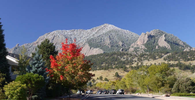
That’s all for now. We’ll continue to monitor the incoming winter storm until its arrival next week. Check back for updates and subscribe for instant email notifications when our new posts and storm updates go live. Have a good weekend. Get out and enjoy what’s left of the fall colors while you can!
We respect your privacy. You can unsubscribe at any time.
Help support our team of Front Range weather bloggers by joining BoulderCAST Premium. We talk Boulder and Denver weather every single day. Sign up now to get access to our daily forecast discussions each morning, complete six-day skiing and hiking forecasts powered by machine learning, first-class access to all our Colorado-centric high-resolution weather graphics, bonus storm updates and much more! Or not, we just appreciate your readership!
.


You must be logged in to post a comment.