
Two different low pressure systems will impact Colorado to end the work week, but unfortunately they will both largely miss the Front Range — one too far north and the other too far south. The Boulder-Denver area will still catch some light precipitation and colder temperatures, but potential snow accumulations are expected to be light and remain mostly west of Interstate 25 and in the Foothills. Things clear out nicely just in time for the weekend, with sunny skies and 70-degree temperatures not far off. Here’s the latest.
At a Glance
- Splitting The Uprights: Two winter storms will impact Colorado over the next 48 hours, but they both largely miss the Front Range with one going north and the other south
- Spotty Rain/Snow Showers Late Thursday: Rain/snow showers will be around Thursday afternoon and evening, with light accumulations possible in the Foothills, but mainly just patchy rain across the lower elevations
- Upslope Snow Favors the Foothills on Friday: Shallow upslope and some instability will spread snow into the area during the day Friday into Friday evening, with light accumulations west of Interstate 25 and in the Foothills.
- Beautiful Sunshine This Weekend: Sunny skies will take over for the weekend. We remain cool on Saturday, but surge well above normal Sunday into early next week with 70-degree temperatures returning!

Go Premium, get all the perks.
Daily Forecast Updates
Get our daily forecast discussion every morning delivered to your inbox.
All Our Model Data
Access to all our Colorado-centric high-resolution weather model graphics. Seriously — every one!
Ski & Hiking Forecasts
6-day forecasts for all the Colorado ski resorts, plus more than 120 hiking trails, including every 14er.
Smoke Forecasts
Wildfire smoke concentration predictions up to 72 hours into the future.
Exclusive Content
Weekend outlooks every Thursday, bonus storm updates, historical data and much more!
No Advertisements
Enjoy ad-free viewing on the entire site.
Light snow accumulations possible for the western Metro
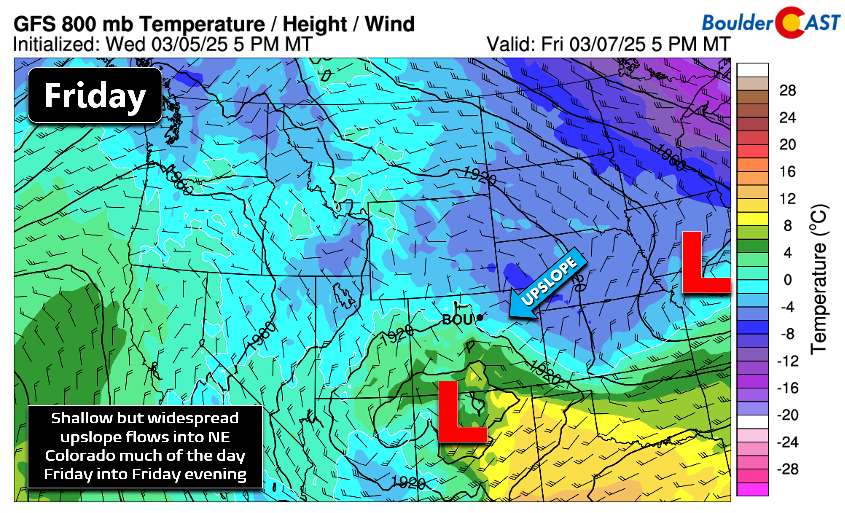
Two different storm systems will impact Colorado over the next 48 hours while the Rockies sit within a broader trough pattern. However, neither storm will be a direct hit to the Front Range, so impacts here will be limited. The 500mb vorticity animation below shows the two distinct systems that will be our weather-makers the next two days. One piece spins off eastward along the Colorado-Wyoming Border on Thursday, while secondary energy consolidates into a cut-off low across New Mexico Friday night.
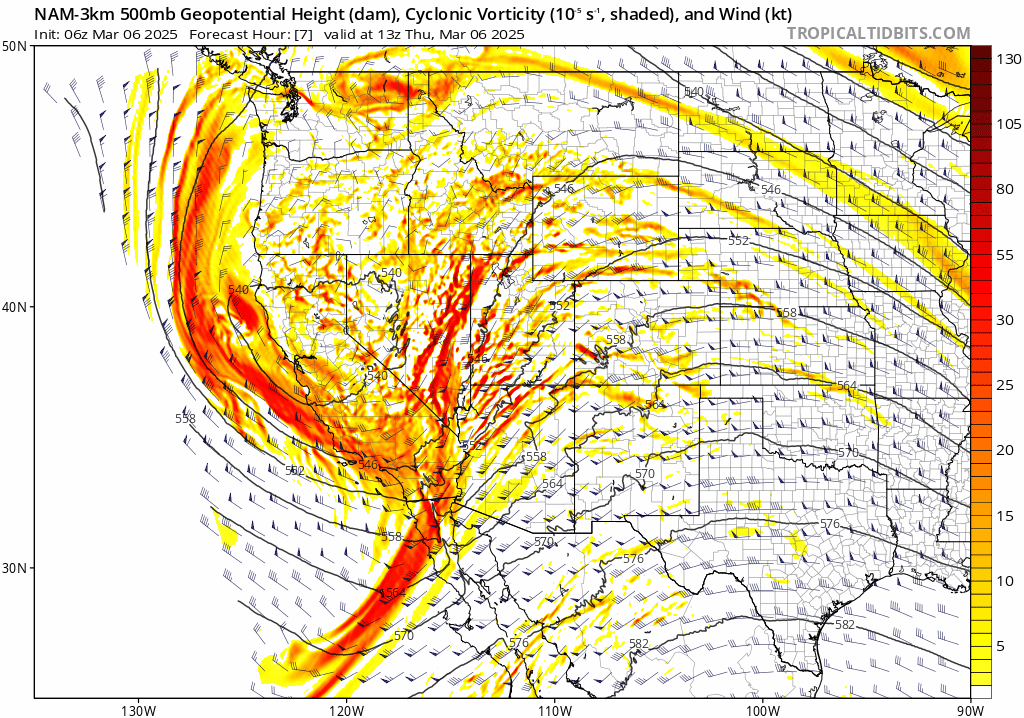
Unfortunately, the way this pattern is set to evolve will put the Front Range right in the middle of both systems. Neither will be a direct hit, nor a complete miss — Mother Nature’s version of “splitting the uprights”, if you will. This will lead to an extended period of lighter and low-end precipitation chances, while heavier swaths of precipitation (mostly snow) will exist to our north from Wyoming into Nebraska and to our south along the Colorado-New Mexico Border.
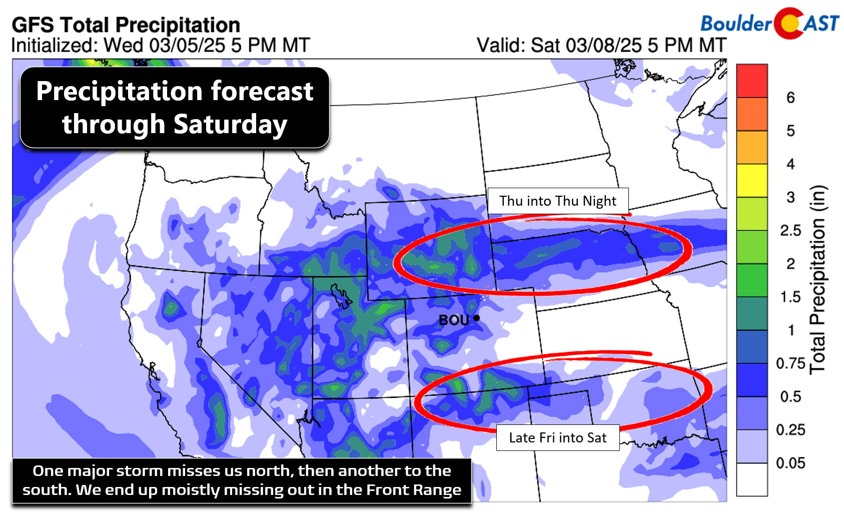
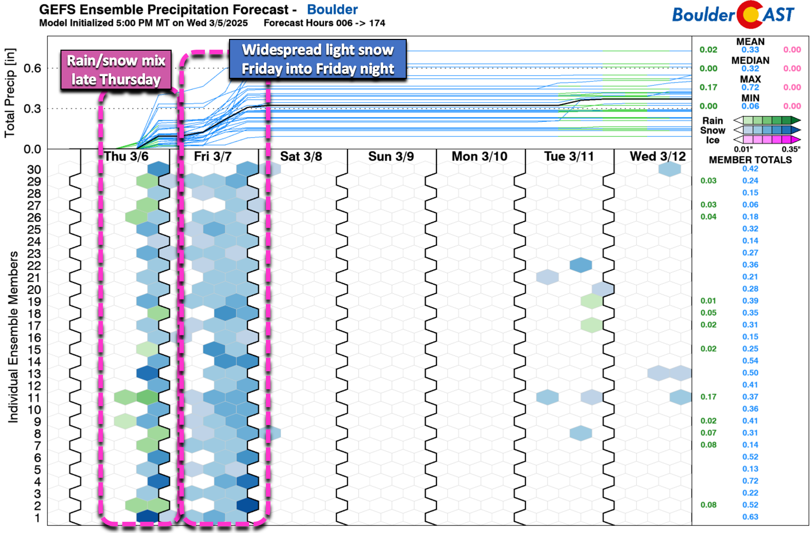
The ensemble precipitation forecast clearly indicates two separate periods of precipitation potential in Boulder, one Thursday afternoon and evening in the form of rain and snow showers. The second chance is better and lasts longer, mainly during the day Friday into Friday evening. Instead of being south of the low, we’ll be to the northside Friday allowing temperatures to be cold enough for all snow with this second wave.
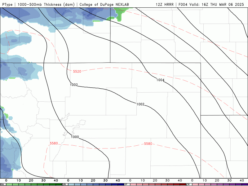
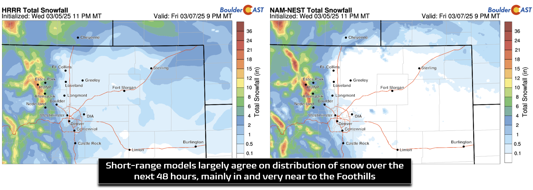
The short-range HRRR model is just now starting to get a look at this entire two-pronged storm. The Thursday portion will favor Larimer and Weld Counties with rain and snow, with just scattered showers around Boulder and Denver. The Friday event will favor mostly the western and southwestern Denver Metro area for light snow, with potentially heavier snow in the Foothills and Mountains.
The more interesting event of the two for us will certainly be the second one on Friday, as widespread cold upslope flows into the Denver Metro area behind the departing low in the Plains and north of the developing one in New Mexico. Friday’s upslope won’t be that strong or deep, not extending higher than about 9000 feet elevation. Outside of this upslope, there’s only very minor forcing for snowfall across the area otherwise, with a little instability over the Foothills also a factor. Thus, we expect most of the accumulating snow to remain in and near the Foothills on Friday.
Short-range models agree fairly well on how things will unfold over the next 36 hours, with accumulating snow mainly confined to the Foothills and immediately adjacent lower elevations, including the Boulder, Golden and Ken Caryl areas.
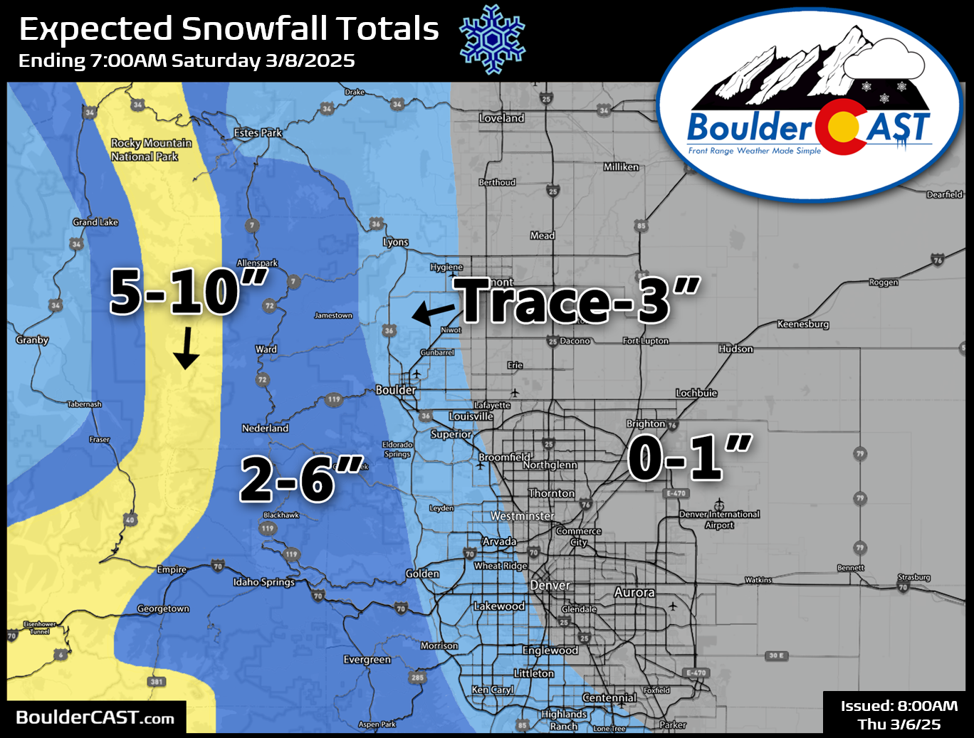
Our snowfall forecast map covering all white stuff through Friday night is shown below. The Mountains and (northern) Foothills will see some of this accumulation Thursday, but most of the snow projected on this map will come Friday late morning into Friday evening. Areas west of Interstate 25 can expect a trace up to 3″ of wet snow, with less than 1″ elsewhere to the east in Denver. Eastern suburbs may not see any real accumulation, or even no snow in some cases.
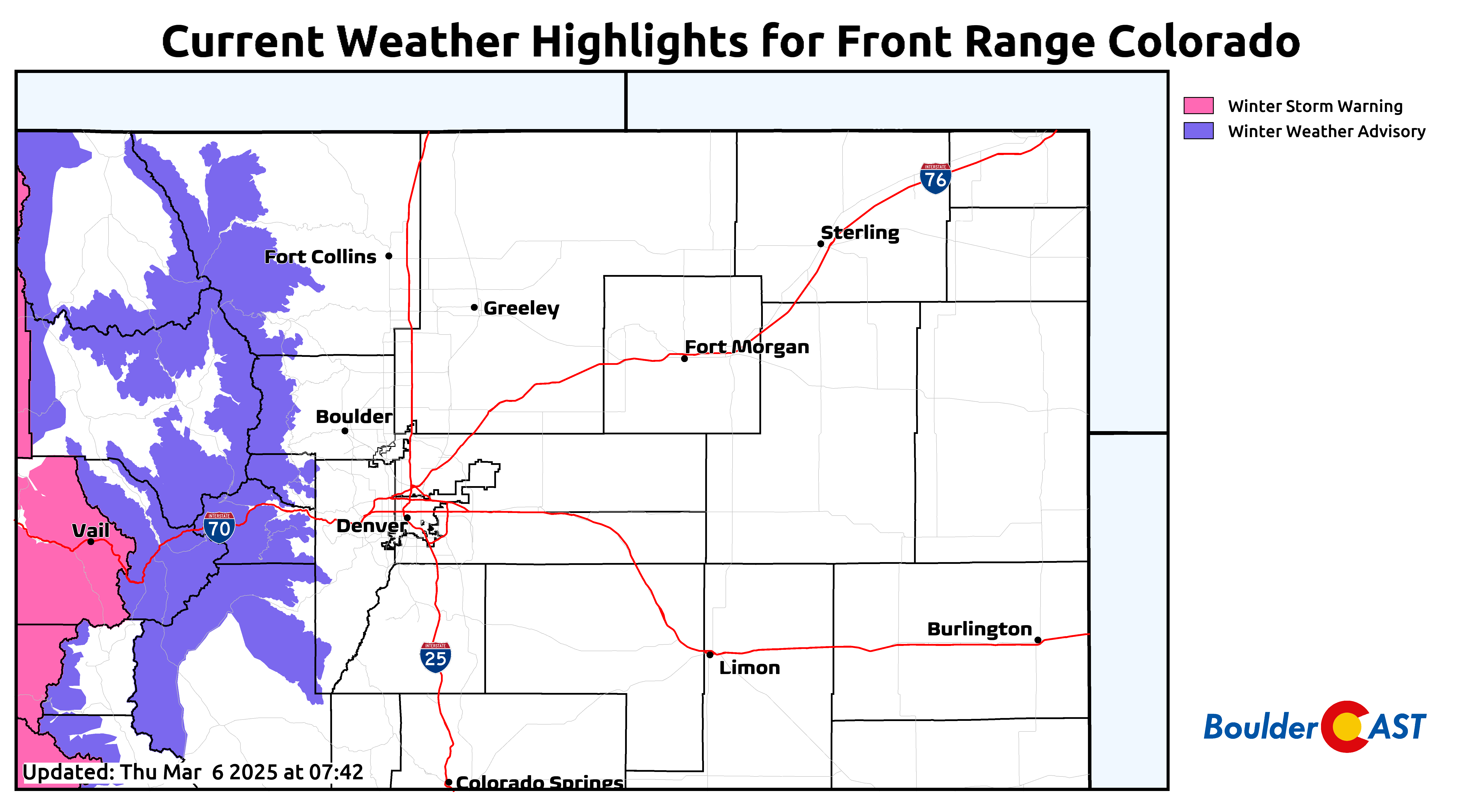
Winter Weather Advisories are posted in the Mountains and will remain in effect throughout this long duration, two part snow event in the High Country (through Friday evening). Plan on winter travel conditions up there much of Thursday and tomorrow, with light to moderate snow falling.
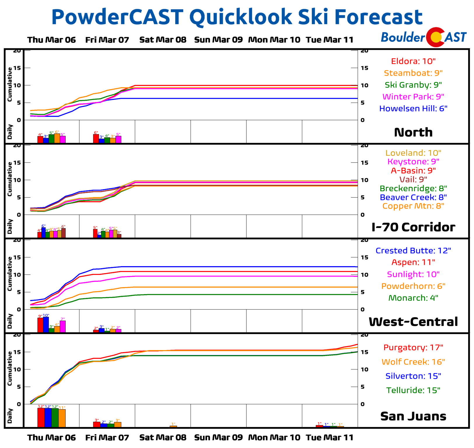
Hopeful skiers will want to head deeper into the Mountains to find the most fresh powder, with the San Juans preferred by this pattern. While many of the central and northern resorts will see 4-10″ of snow, southwest Colorado’s winter playgrounds will pick up 12-18″ by Saturday morning!
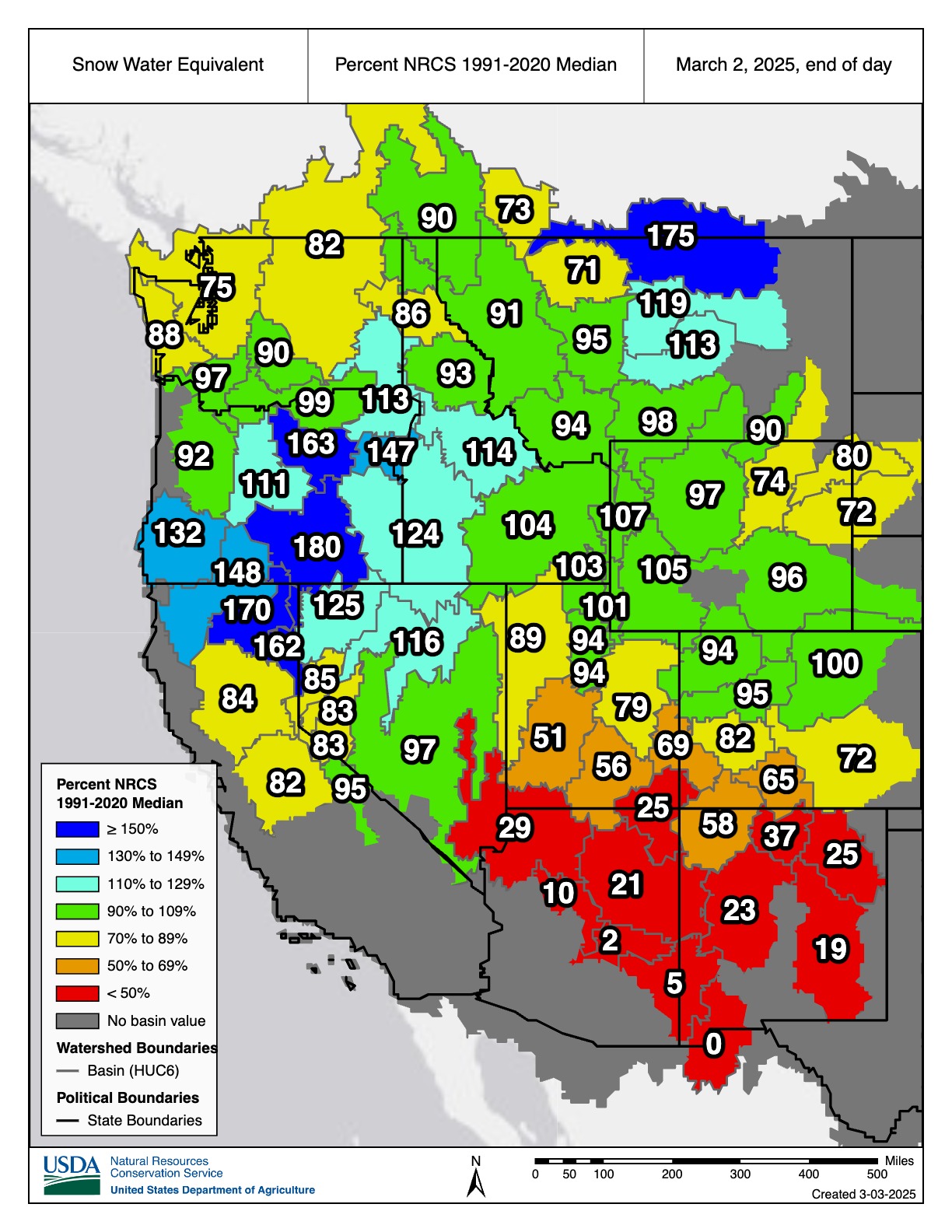
The southern bias for the main (Friday) storm will also help with ongoing snowpack shortages across southern Colorado. While the South Platte Basin has normal snowpack as of writing, the rest of the state is lagging behind a bit:
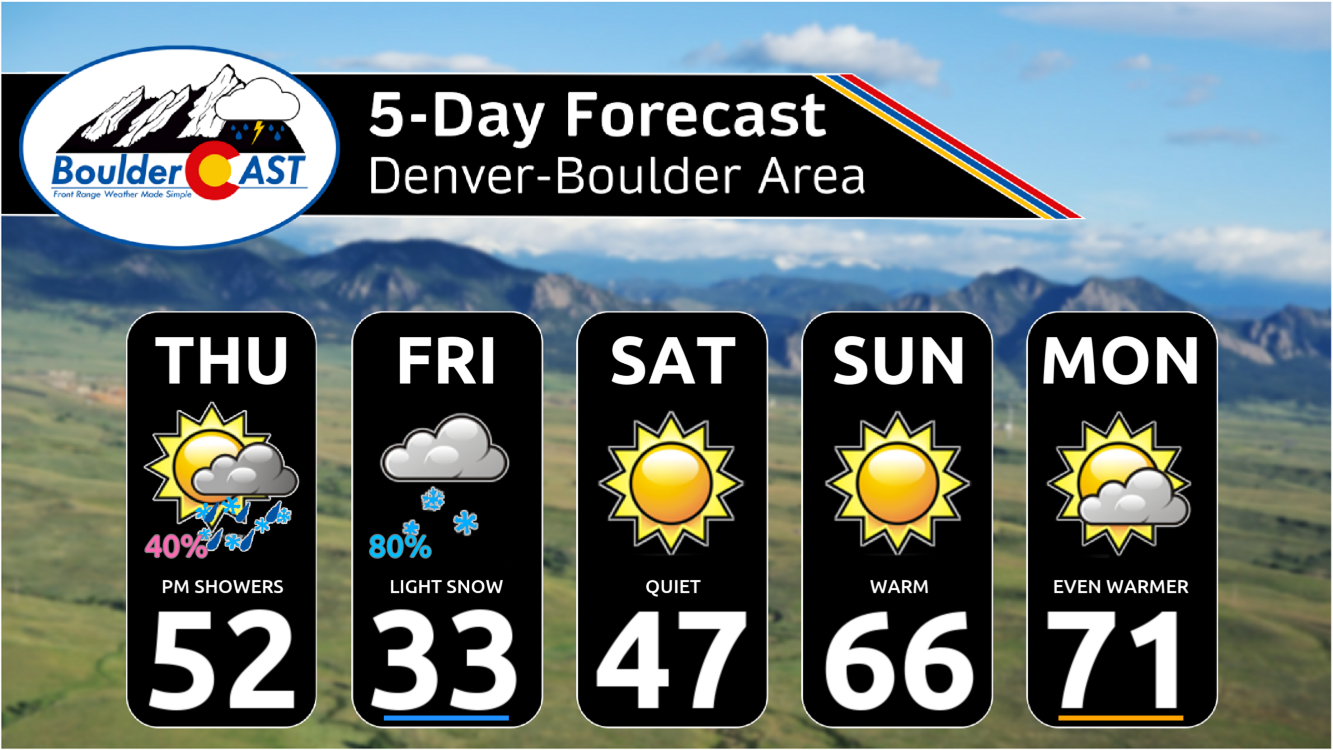
Here’s a quick timeline of the inbound unsettled stretch ahead:
- Thursday: Partly cloudy in the morning becoming mostly cloudy later in the day. Spotty rain showers will develop during the afternoon and evening, possibly mixing with snow in the heavier cells. Little to no accumulation is expected across the lower elevations, with perhaps 1-3″ in lucky Foothills locations from Boulder County northward. Highs reach the lower 50s in the afternoon, falling into the 30s by evening.
- Thursday night: Most of the rain/snow showers end around midnight with predominantly dry weather heading into Friday morning. Overnight lows slightly below freezing.
- Friday: Overcast skies with moist upslope increasing during the early day period. Light snow is expected to break out by late morning or early afternoon, continuing into the evening. Areas west of Interstate 25 will see light snow accumulations, greatest near the base of the Foothills. With temperatures in the low to middle 30s and the March sun, roads should remain just wet with minimal to no travel impacts.
- Friday night: Light snow continues across the western Metro area through about midnight before tapering off, lingering longest southwest of Denver. Slick roads may develop after sunset but travel impacts should be minor. Temperatures fall into the 20s.
- The Weekend: Quiet conditions with highs in the upper 40s on Saturday, followed by much warmer conditions in the 60s and 70s Sunday into early next week as strong high pressure builds into the area.
We’ll experience the full gamut of springtime Colorado weather in the extended — from snowflakes back to the 60s and 70s in just a few short days. Enjoy!
Get BoulderCAST updates delivered to your inbox:
Go Premium, get all the perks.
Daily Forecast Updates
Get our daily forecast discussion every morning delivered to your inbox.
All Our Model Data
Access to all our Colorado-centric high-resolution weather model graphics. Seriously — every one!
Ski & Hiking Forecasts
6-day forecasts for all the Colorado ski resorts, plus more than 120 hiking trails, including every 14er.
Smoke Forecasts
Wildfire smoke concentration predictions up to 72 hours into the future.
Exclusive Content
Weekend outlooks every Thursday, bonus storm updates, historical data and much more!
No Advertisements
Enjoy ad-free viewing on the entire site.
Enjoy our content? Give it a share:


You must be logged in to post a comment.