After weeks of unseasonable warmth, the Front Range is staring down its first taste of winter. Mild weather will continue for the next few days, including a beautiful Thanksgiving holiday, but by Friday night a powerful cold front will surge into Colorado, ending this historic snow drought with our first flakes of the season likely to fall. Read on for a full breakdown of what to expect and when, including our preliminary snowfall forecast map for Friday night.
What You Need to Know
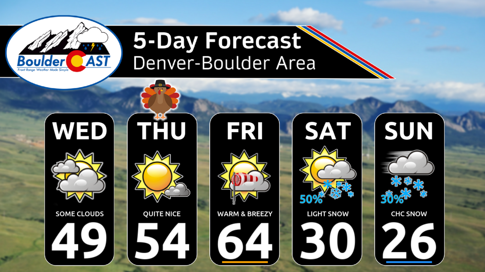
- Wednesday: Partly to mostly cloudy skies, highs in the upper 40s to low 50s — still a bit cooler than average.
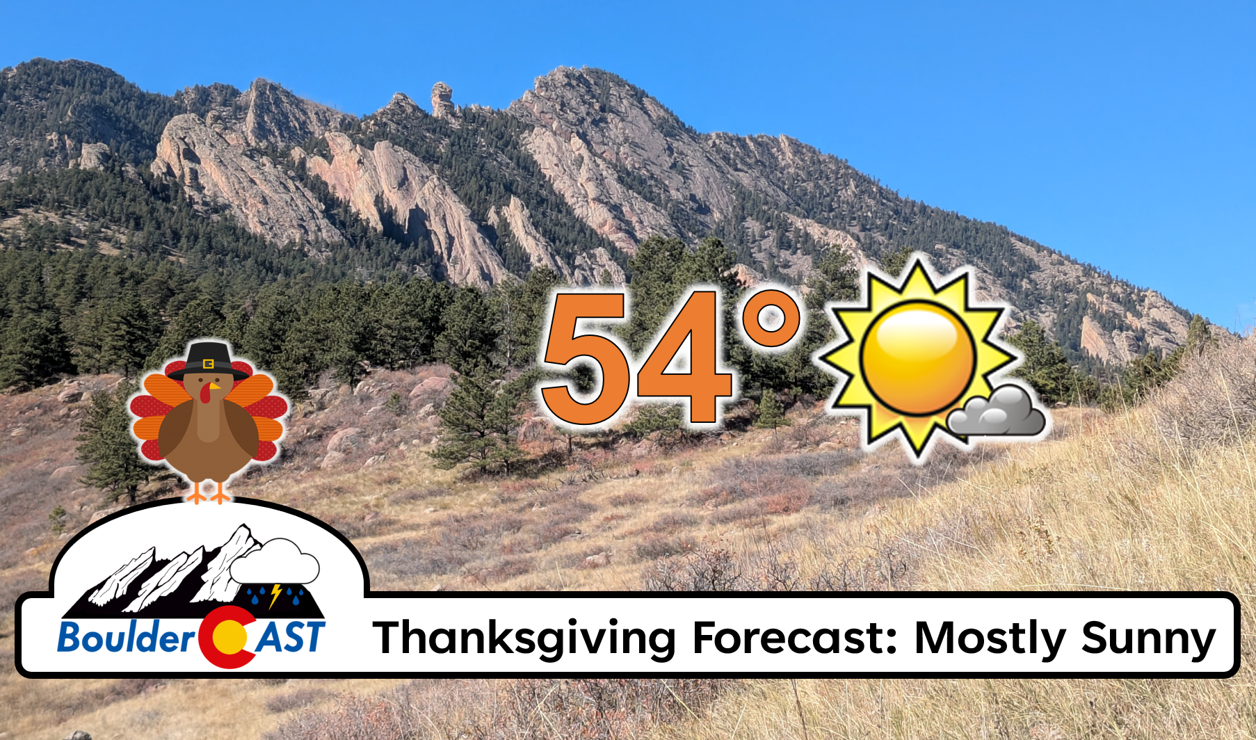
- Thanksgiving Thursday: Ridge of high pressure brings sunshine, light winds, and highs in the low to mid‑50s — ideal holiday weather.
- Friday: Warmest day of the stretch with highs in the 60s; unusual warmth for late November, but just business as usual in this record‑setting warm month.
- Friday Night Cold Front: Strong Canadian front arrives in the evening (possibly in two waves), ending the warmth and ushering in winter’s first blast.
- Weekend Cold: Bitter temperatures lock in — highs near freezing Saturday, only 20s Sunday; lows in the teens, single digits possible.
- Snow Chances: Two weak storm systems (Fri night–Sat and Sun) likely will deliver Boulder’s first measurable snow in 223+ days; light accumulations for the Metro (1-4″), but 6-12″ in the Mountains with slick travel on passes.

Go Premium, get all the perks.
Daily Forecast Updates
Get our daily forecast discussion every morning delivered to your inbox.
All Our Model Data
Access to all our Colorado-centric high-resolution weather model graphics. Seriously — every one!
Ski & Hiking Forecasts
6-day forecasts for all the Colorado ski resorts, plus more than 120 hiking trails, including every 14er.
Smoke Forecasts
Wildfire smoke concentration predictions up to 72 hours into the future.
Exclusive Content
Weekend outlooks every Thursday, bonus storm updates, historical data and much more!
No Advertisements
Enjoy ad-free viewing on the entire site.
A warming trend the rest of the work week
For Wednesday, skies will bounce between partly and mostly cloudy, with highs in the upper 40s to low 50s. That’s still a touch cooler than average for late November, but we’re trending upward.
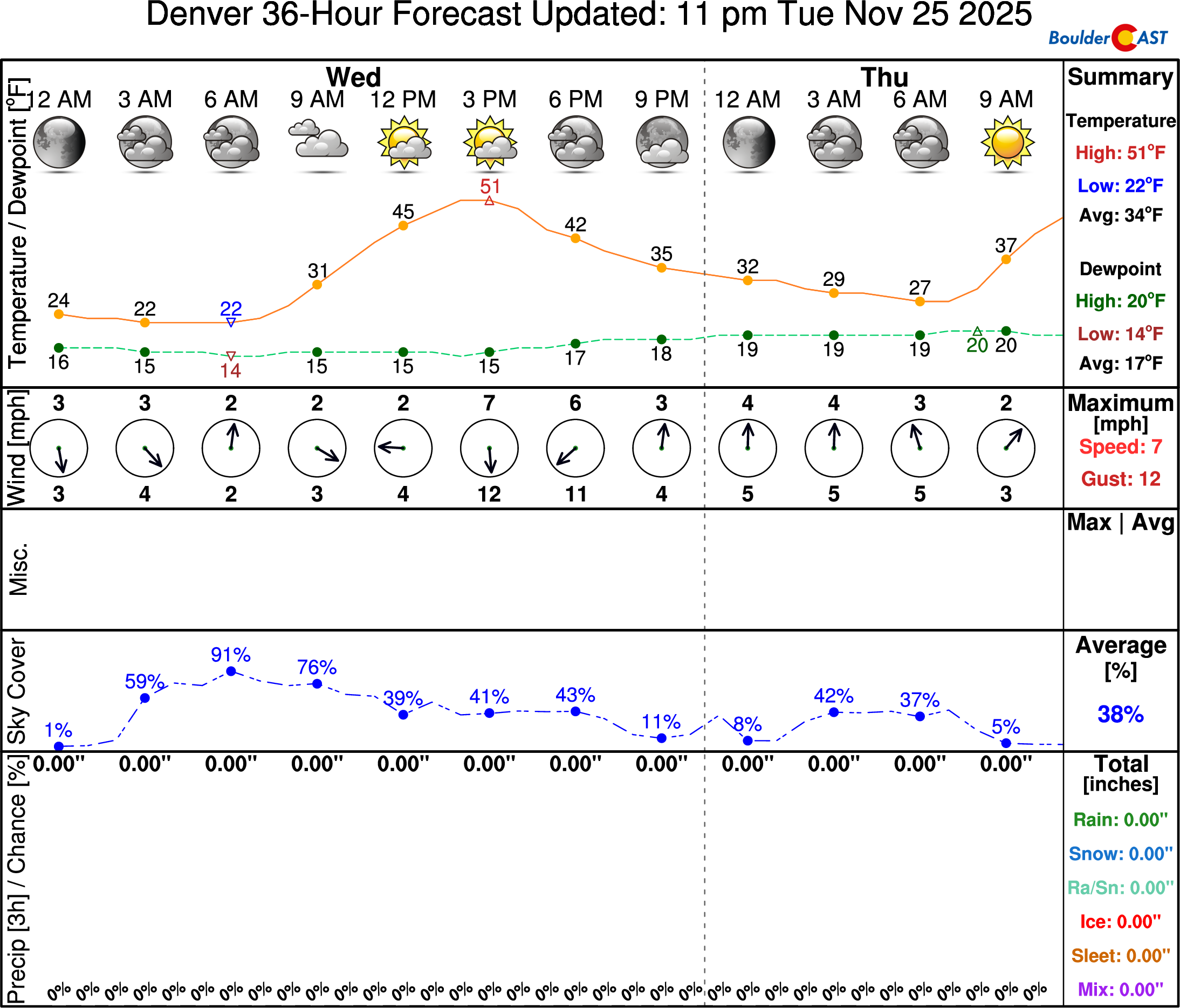
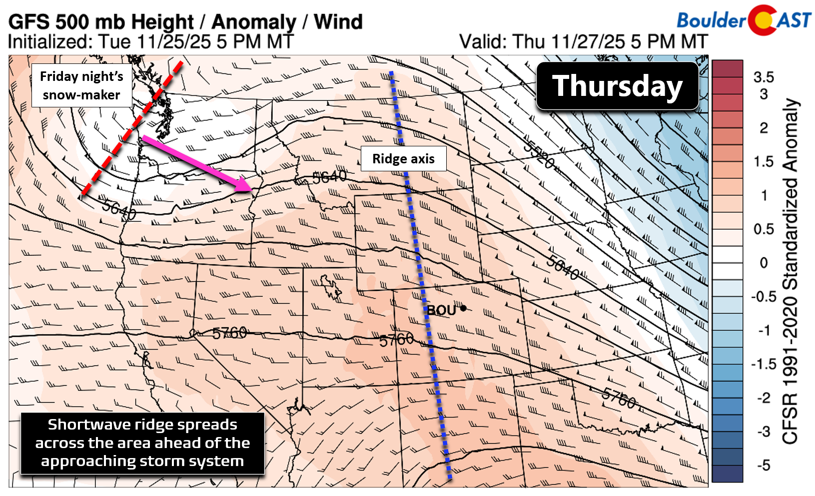
By Thursday, a subtle ridge of high pressure noses into Colorado, and the timing couldn’t be better.
Sunshine will dominate, winds will stay light, and highs will rebound into the low to mid-50s. In other words, a picture-perfect holiday forecast. Whether you’re tossing the football around, carving into turkey, or journeying out and about into nature, the weather will cooperate beautifully. Skiers, however, will have to keep waiting — the Mountain slopes remain starved for fresh powder for now.
On Friday, the warming trend will peak. Boulder and Denver will surge into the 60s, capping off what’s already been an unusually warm November (nearly two-thirds of the month has had 60° or warmer temps). In most years, this kind of late-November warmth would be rare. Not in 2025.
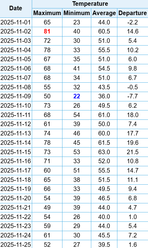
Temperatures so far each day in November 2025 in Boulder
Friday’s warmth will be the last of it, though. A strong cold front barrels down the Front Range Friday evening, shutting the door on our extended fall and ushering in the season’s first true blast of winter. The front should arrive near sunset, possibly in two waves several hours apart. The air mass behind it originates in northern Canada — the coldest of the season so far.
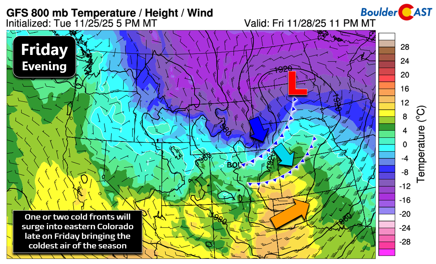
The incoming bitter cold will remain locked in through the weekend into early next week. Highs Saturday will hover near freezing, dropping into the 20s for Sunday. Overnight lows sink into the teens, with single digits possible if skies clear.
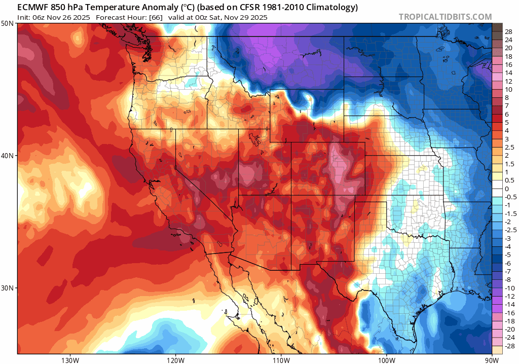
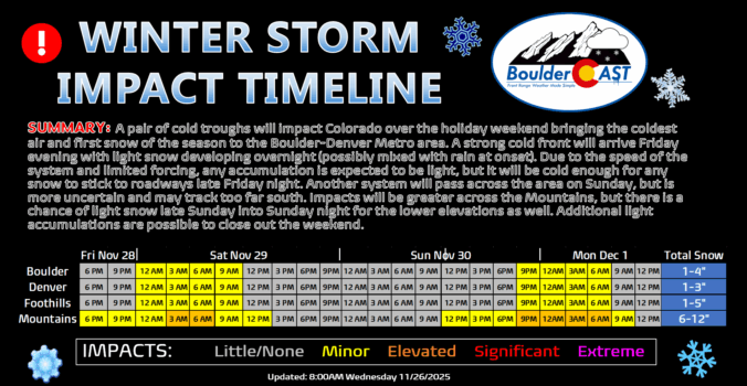
This persistent cold through the weekend is the most certain aspect of the extended forecast. The one you’re probably more interested in, the potential for snowflakes, is not as clear. The problem is, this pattern isn’t a great one for us, with most intense cold air remaining off to our east and only shallow (largely southeasterly) upslope flow for Metro area. The Mountains will probably do okay this weekend with several waves of moist northwest flow slamming into the Continental Divide. East of the Mountains, we’ll have just a brief period of lift from the passing storm system Friday night into early Saturday which may overlap with a few hours of C-tier upslope. We’re actually tracking two disturbances this weekend which should offer up the potential for light snow in our area, but you’d be hard pressed to tell that from the ensemble precipitation forecast graphic below. Models are so unsure when and where the snow will hit this weekend that it all just smears out into a sporadic peppering of light snow from Friday night through Monday morning.
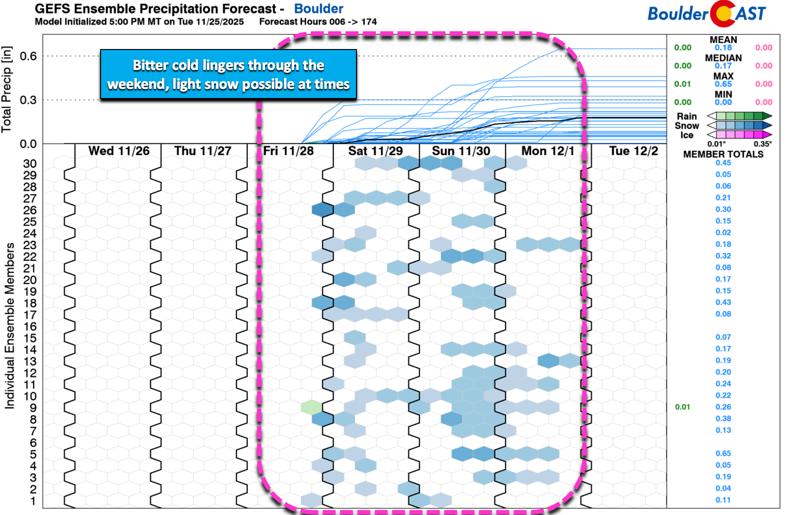
That said, we do believe there will be two distinct waves of light snow headed for our area:
- Friday night into early Saturday as the cold air settles in behind the initial strong cold front and as the first trough passes
- Sunday and/or Sunday night as a secondary trough sweeps across Colorado
The second system on Sunday is too far out and too uncertain to really discuss in much detail right now, and models have been trending further south with the best lift into southern Colorado. Worst case scenario looks to be a couple inches of snow in the Boulder area late in the weekend, with the most likely scenario being another round of hit or miss snow showers with minimal accumulations (less than 2″).
While Friday night’s snow chance isn’t fully set in stone yet, it is a bit more clear. Scattered snow showers will spread across the area beginning in the late evening hours, with that chance lasting into Saturday morning. Brief rain may occur at the onset. 3 to 6 inches will fall across the Mountains leading to slick travel on the passes. Across the lower elevations, we’re looking for a sporadic shot of light snow, generally less than 2 inches for Boulder and Denver, and less than 3 inches in the Foothills. Upslope is only a very minor player with this system.
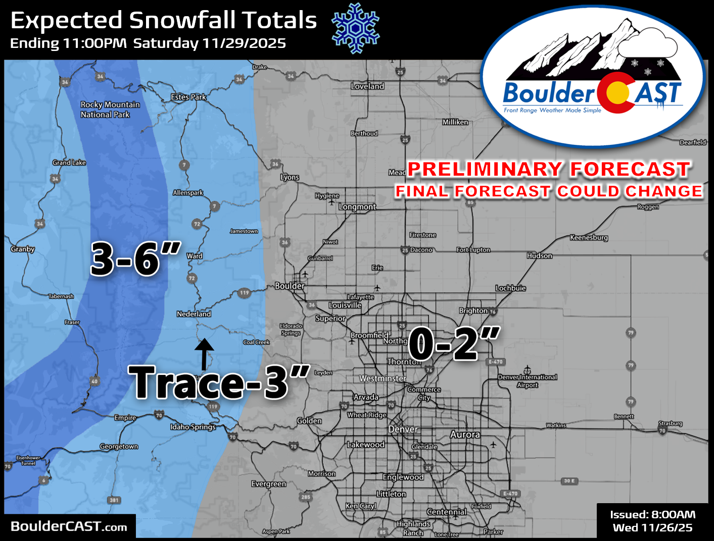
Even with light totals, Friday night’s cold will lock in whatever flakes fall, potentially making roads slick in the Metro area. And as always, the first snow of the season tends to bring plenty of accidents, regardless of how much actually sticks. The worst travel conditions will be felt in the Mountains. Our Winter Storm Impact Timeline below also includes some projections for Sunday, but just be aware that the timing and degree of travel impacts then are much less certain.

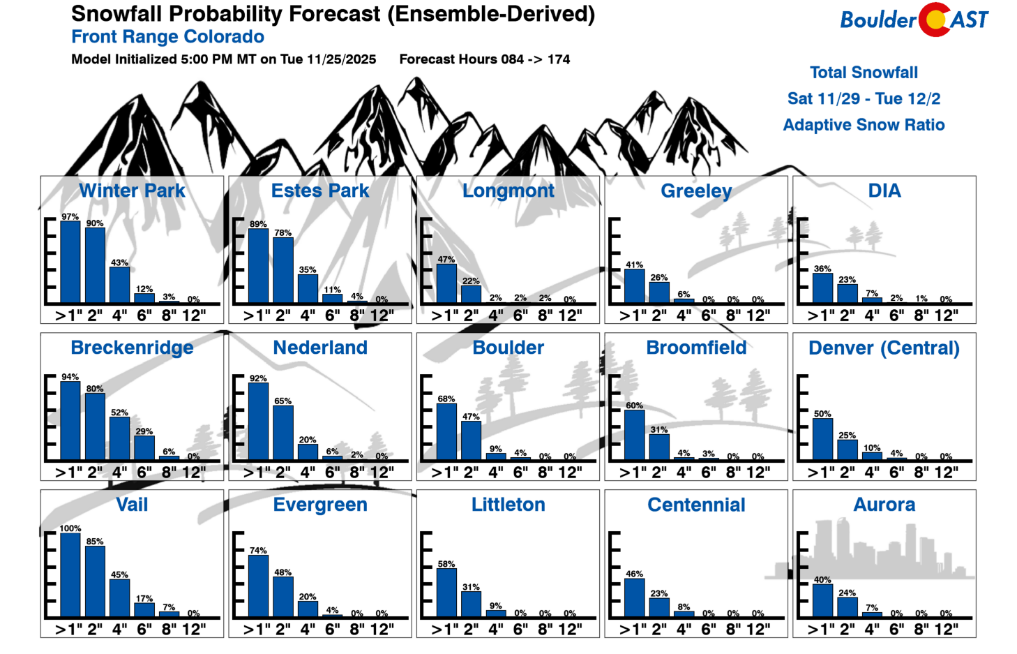
Across the entire weekend, snowfall totals are set to be light in the Metro area, with many of us picking up 1 to 3 inches. According to our latest Snowfall Probability Charts, the chance to see more than 4 inches is pretty low for everyone except the Mountain towns.
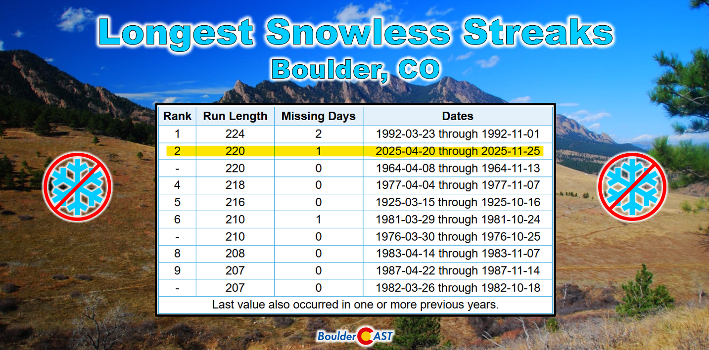
Given there are two chances of snow during this upcoming bitter cold holiday weekend, and even if accumulations are light, Boulder should finally see its first snowfall of the season, etching whatever date that ends up being into the record books.
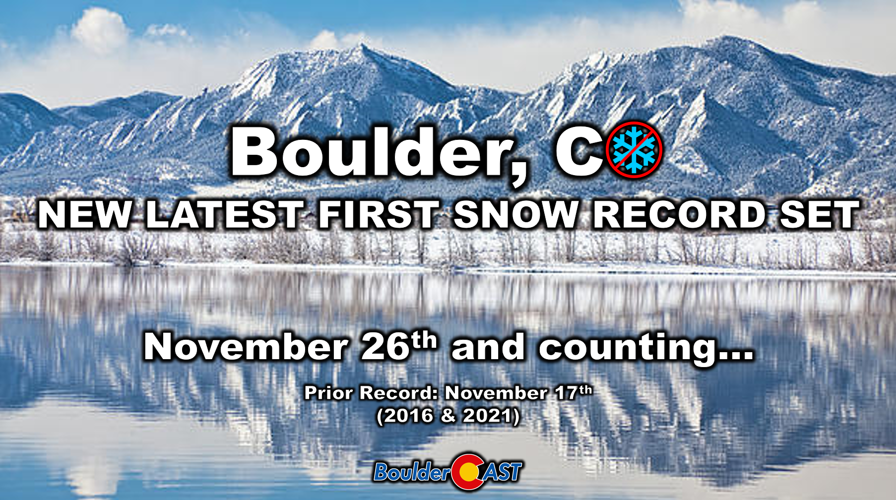
This would also bring an end to our snow drought which will land as one of Boulder’s all-time longest at 223 or more days (currently at 220 as or writing):
Bottom Line
Enjoy the mild, sunny weather while it lasts the next few days. By the weekend, the weather will flip decisively towards winter. After such a dry autumn, a little bit of snow is something we can all be thankful for.
From the entire BoulderCAST team, we wish you a happy and joyous Thanksgiving!
![]()
P.S. Our special “first snow” BoulderCAST Premium sale ends Monday December 1st.
Join Now and Save 30%
Holiday Day-By-Day Forecast:
- Wednesday: Partly to mostly cloudy and quiet. Highs around 50 degrees.
- Thanksgiving Day: Mostly sunny and calm. Highs in the low to middle 50s.
- Friday: Warm and breezy with abundant wave clouds. Highs in the low to middle 60s. A strong cold front arrives during the evening with tumbling temperatures. Snow showers beginning in the late evening or overnight, perhaps briefly mixing with rain at the onset. Light snow could lead to slick roadways.
- Saturday: Light snow possible, mainly in the morning. Cold temperatures. Highs near or below freezing. Snow totals from the first wave of less than 2″ expected.
- Sunday: Overcast with a second chance of light snow, mainly in the late-day period into Sunday night. Highs very cold in the mid to upper 20s. Any accumulation should be light (0-3″).
Spread the word, share our crazy Colorado weather:
Go Premium, get all the perks.
Daily Forecast Updates
Get our daily forecast discussion every morning delivered to your inbox.
All Our Model Data
Access to all our Colorado-centric high-resolution weather model graphics. Seriously — every one!
Ski & Hiking Forecasts
6-day forecasts for all the Colorado ski resorts, plus more than 120 hiking trails, including every 14er.
Smoke Forecasts
Wildfire smoke concentration predictions up to 72 hours into the future.
Exclusive Content
Weekend outlooks every Thursday, bonus storm updates, historical data and much more!
No Advertisements
Enjoy ad-free viewing on the entire site.


You must be logged in to post a comment.