A new storm system will drop across far western Colorado Tuesday night, but it’s heading for the deserts of southern Arizona. In the process of bypassing the Front Range, it will bring light snow to the Denver Metro area starting Tuesday night as temperatures tumble below freezing. Intermittent snow showers and flurries will linger through the day Wednesday leading to minor accumulations in Boulder and Denver, but higher totals are favored further south. There is also the potential for a more impactful storm to hit our area on Saturday, but that continues to look more unlikely by the day. Read on for the latest on the chilly and unsettled days ahead.
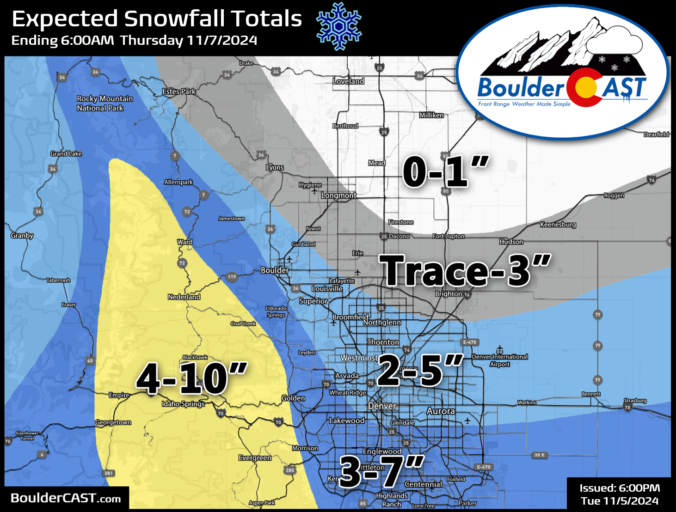
Updated (Tue 11/5/24 7:00 PM): The higher-end outcomes we touched on in the original post have become more likely give the latest model guidance. Though some snowflakes are already flying, we have amended our snowfall forecast map with a slight increase of 1-2″ across the board for the Metro area. Remember this is a long duration (mostly light) snowfall event, lasting from Tuesday evening at least into Wednesday afternoon. Light snow may continue well into Wednesday night, but this is still uncertain. Forecast snow totals will be reached over time, not immediately.
At a Glance
- Next Round of Snow: The Denver Metro area is expected to see light, persistent snow starting late Tuesday evening behind a cold front, but the most significant snowfall will stay south of Denver and in the southern Foothills.
- Snowfall Amounts: 1-6″ of snow are favored for most of us, with up to 10″ in the southern Foothills and Palmer Divide
- Uncertainty for a Boom? There is some uncertainty in the near-term forecast, with a ~20% chance of higher totals if the storm tracks slightly further north than forecast (Updated: this high end scenario is now most likely and includes as part of our forecast)
- Minor Travel Impacts: Travel impacts are expected with this system, mainly from Boulder southward, with likely slick spots and cold temperatures for the Wednesday AM commute.
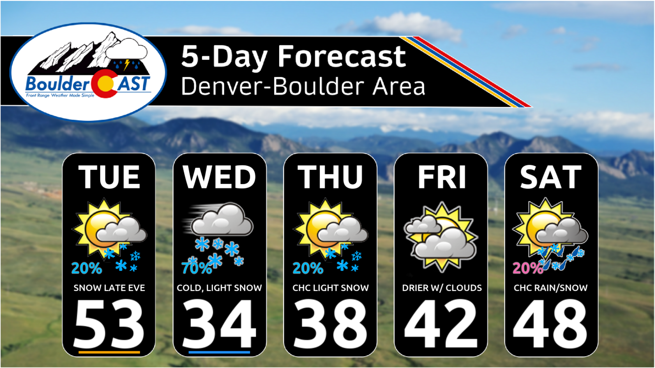
- Staying Cold: Highs only in the 30s are expected Wednesday and Thursday, warming into the lower 40s by Friday — all below normal readings!
- Weekend Blizzard: The chance of any significant rain/snow in the extended has waned considerably. Most likely Saturday is warmer and drier, but there’s still ~10% chance of significant snow if the exiting low pressure tracks just right.
Daily Forecast Updates
Get our daily forecast discussion every morning delivered to your inbox.
All Our Model Data
Access to all our Colorado-centric high-resolution weather model graphics. Seriously — every one!
Ski & Hiking Forecasts
6-day forecasts for all the Colorado ski resorts, plus more than 120 hiking trails, including every 14er.
Smoke Forecasts
Wildfire smoke concentration predictions up to 72 hours into the future.
Exclusive Content
Weekend outlooks every Thursday, bonus storm updates, historical data and much more!
No Advertisements
Enjoy ad-free viewing on the entire site.
Light snow is the only snow
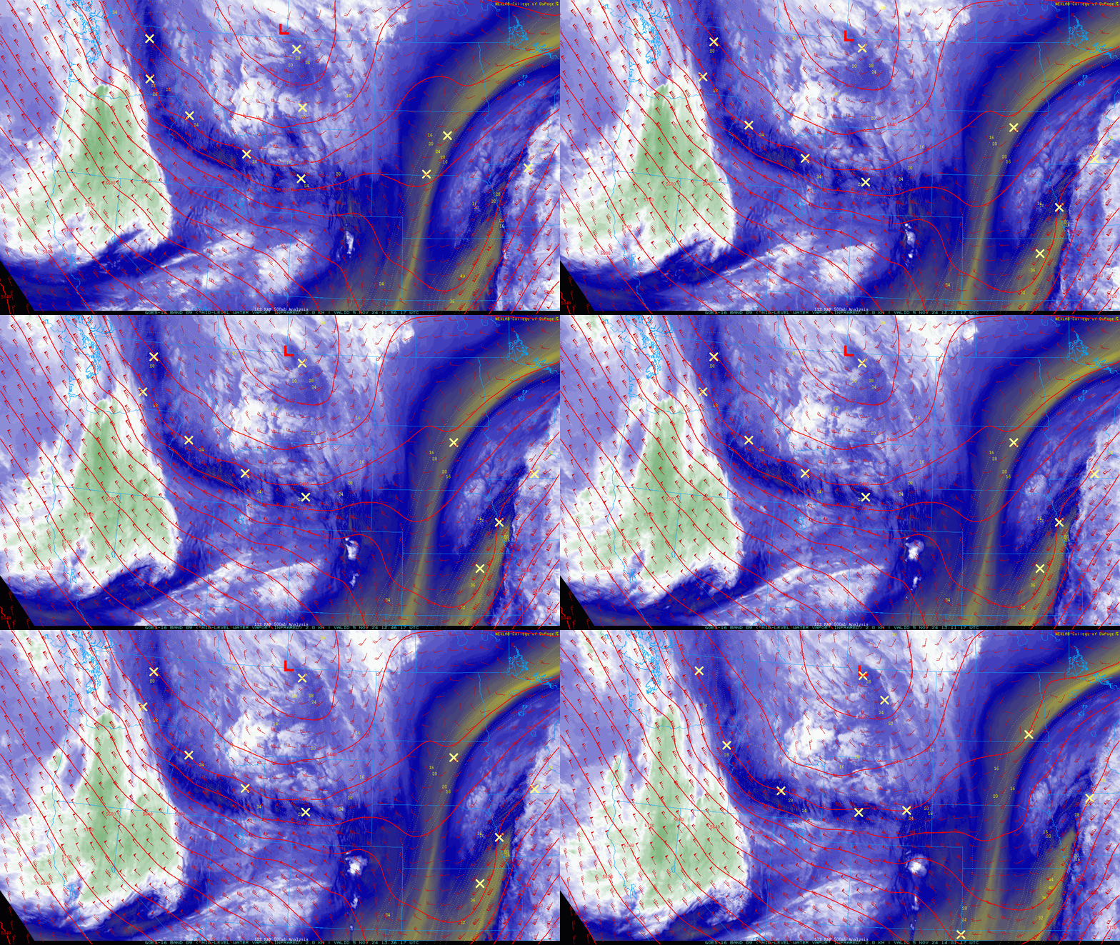
Despite fresh snow still coating the Flatirons, our next snow-maker is already taking shape to the northwest Tuesday afternoon. The main trough is located over Montana and Idaho right now, as seen in the water vapor animation below:
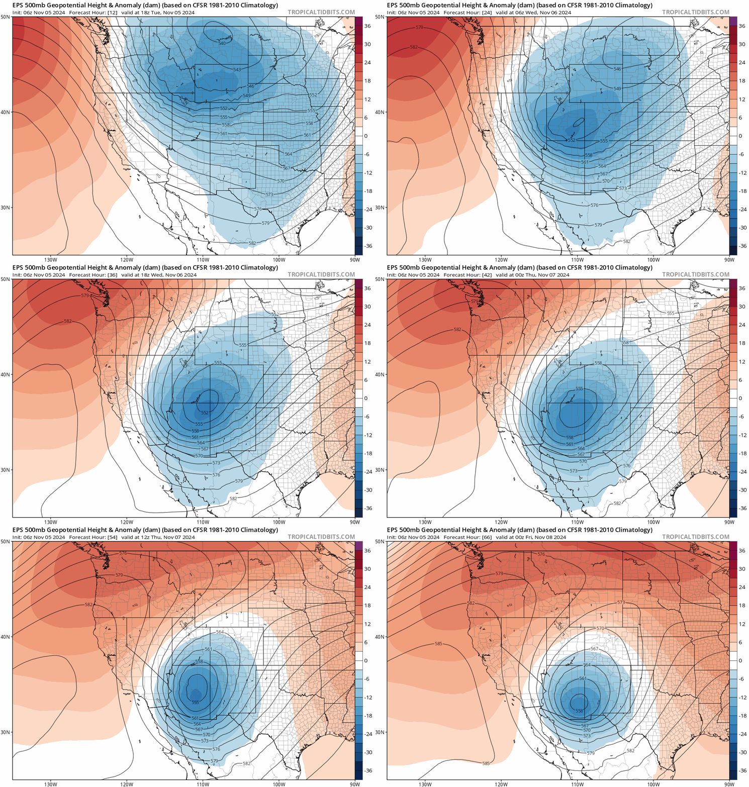
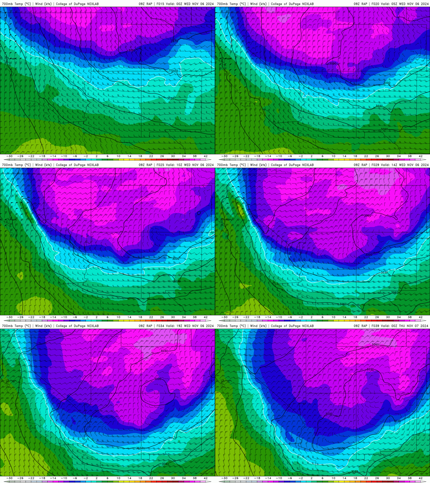
Similar to Sunday’s event, a piece of energy will break off from the main trough and dive straight south into Arizona Tuesday night through Wednesday (see below) forming a new cut-off low, one that retrogrades slightly as it tracks towards to Sonoran Desert. As it passes south along the Colorado-Utah border Tuesday night, it will make its closest approach to Denver with light snow spreading into our area as flow turns northerly.
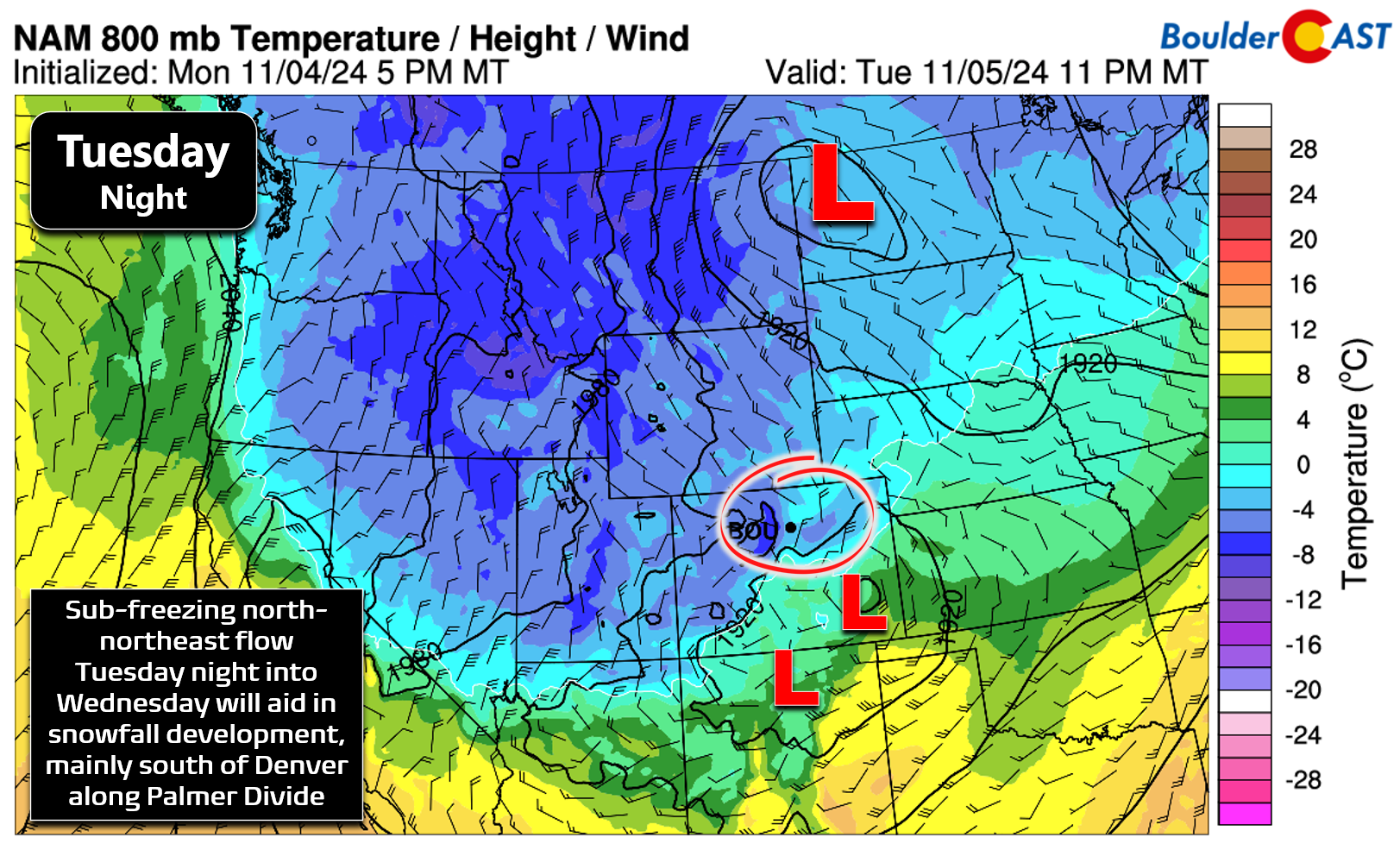
The problem we will once again run into with this system is that it will largely stay too far west and south to bring significant impacts to Boulder or Denver. As low pressure develops in southeast Colorado Tuesday night, we will get a nice surge of NNE-erly flow into the Metro area at the surface:
A bit higher in the atmosphere, winds will be almost due northerly Tuesday night through Wednesday night, with minimal upslope component slamming into the nearby Foothills and Mountains. This northerly direction will favor the far southern Metro area and Palmer Divide which interact best with that wind direction, rather than Boulder or Denver proper.
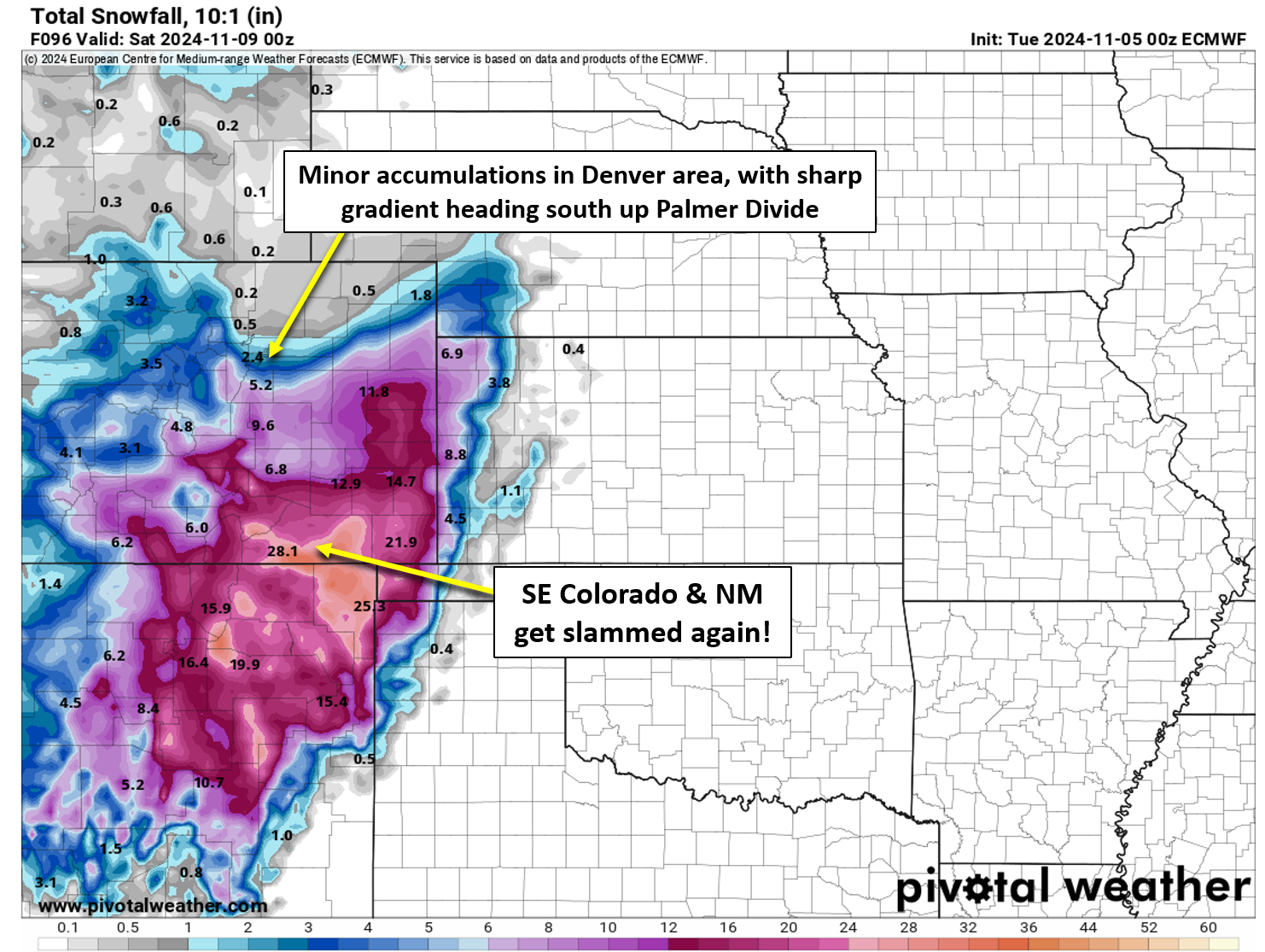
Nonetheless, there will be an extended period of weak forcing and weak upslope that will keep things cloudy and cold the next few days with intermittent snow showers or flurries in our area, most numerous south of Denver. Don’t get too excited though, this storm system will greatly favor southeast Colorado and New Mexico, with the Denver Metro area mostly on the outside looking in (to the snow globe). Just check out the latest Euro snowfall forecast below — 1+ foot snow totals are possible for a broad region to our south by Friday. However, note the sharp north-south gradient in snow heading south out of Denver.
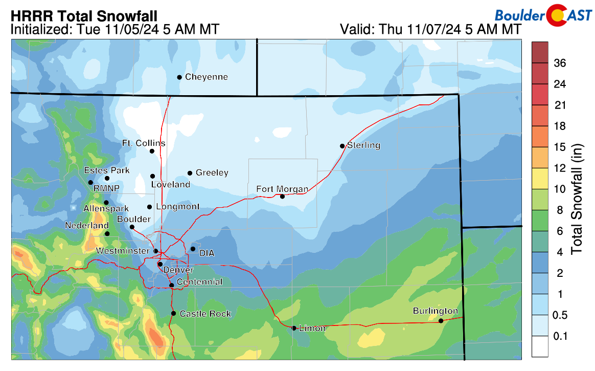
Short-range models show a similar sharp gradient south of the Denver Metro area, with ~1″ in Boulder and Denver, but 4-8″ heading up the Palmer Divide and in portions of the southern Foothills.
The chilly air surging south into the Front Range Tuesday night will be colder than the last storm, so there won’t be much if any rain involved with this event. Instead, temperatures will fall towards and below freezing Tuesday evening with snow becoming the only precipitation type — where there is precipitation that is. Keep in mind, this is a long duration, very light snow event. There isn’t a specific timeframe for widespread accumulating snow in Boulder and Denver. Basically anytime from late Tuesday evening through Wednesday evening (or perhaps longer) could have snowflakes falling from the sky while we are under the gun of north-northeast flow and weak lift from the distant trough. With temperatures at or below freezing at the surface the entire time, the intermittent light snow will accumulate slowly but minimally (less than 3″).
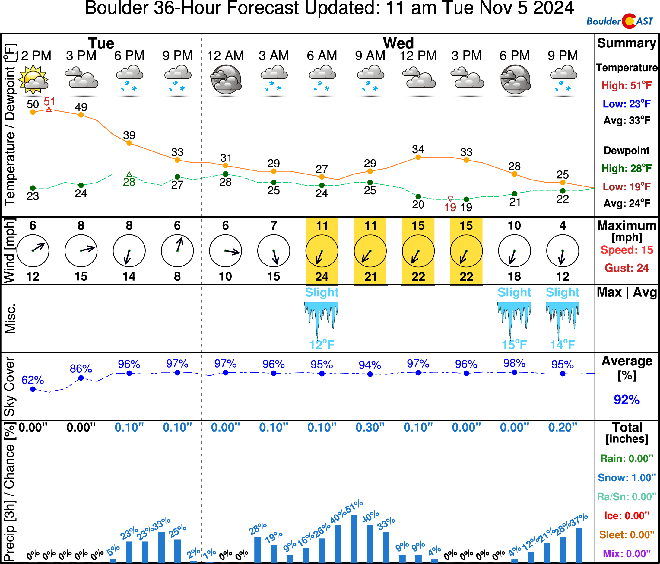
There is still some surprising uncertainty with this storm. About 20-30% of ensemble solutions develop things slightly further north with better upslope into the Denver area (more towards northeasterly). In these scenarios, 2-6″ of accumulation would be favored for us. The ensemble plumes below are for Boulder:
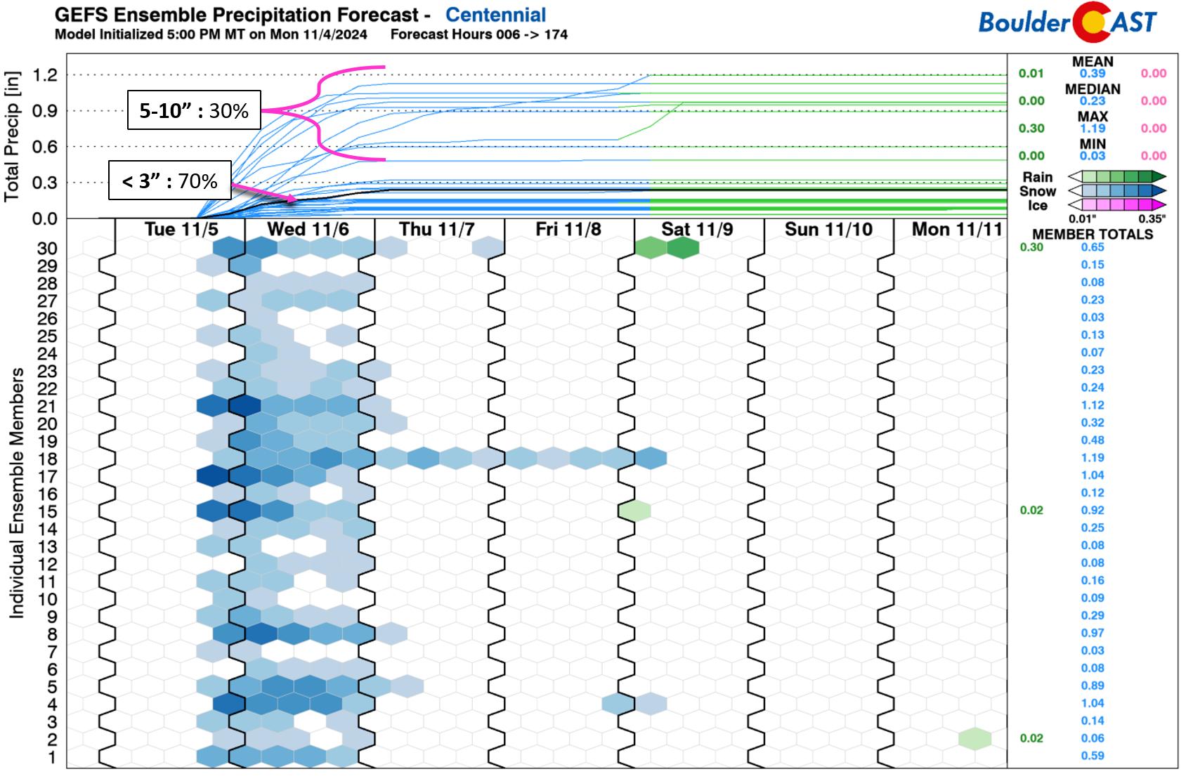
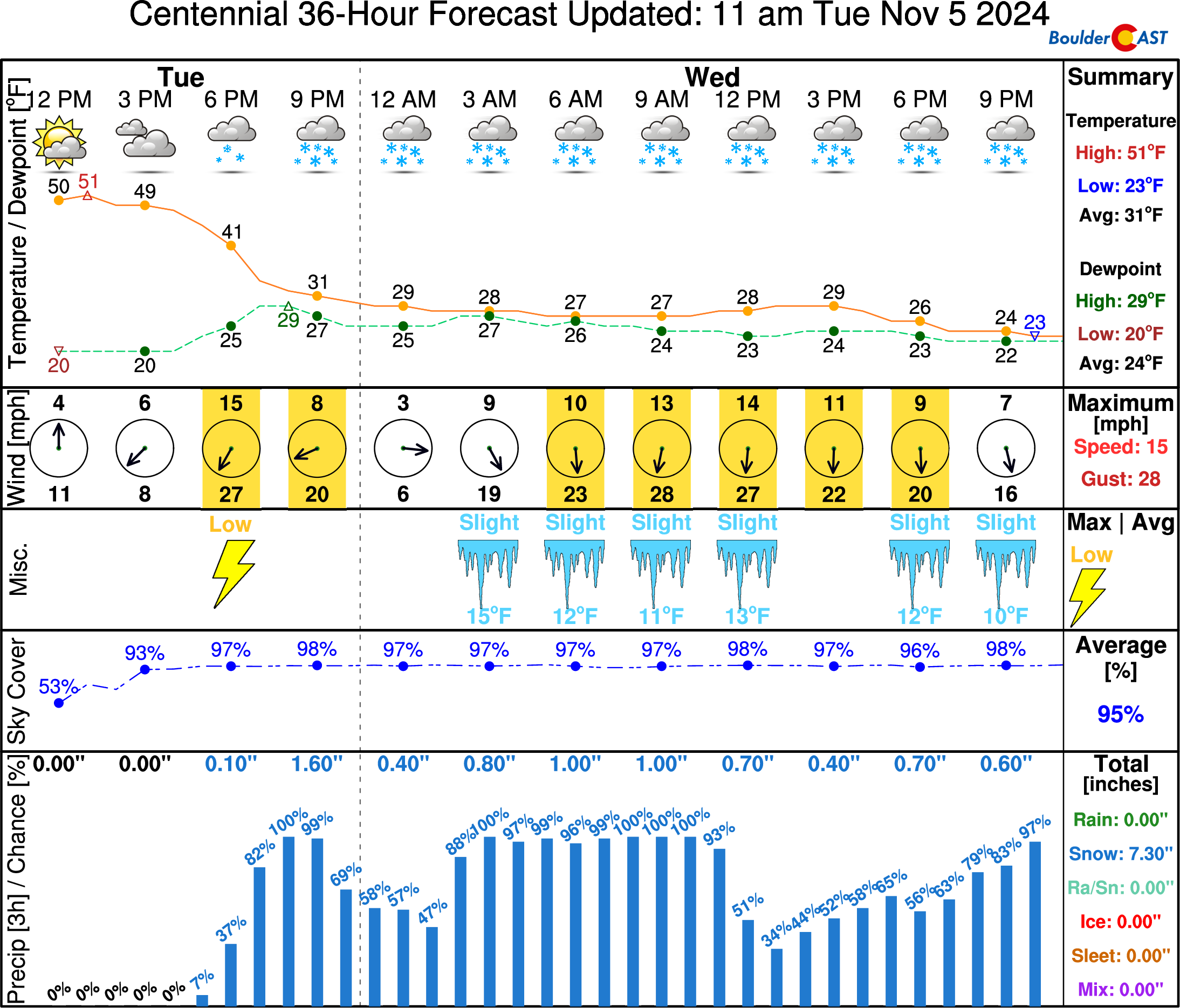
Centennial, located in the far southern tier of the Metro area, would see a more substantial jump in snow should these less likely northward outcomes come to fruition, with upwards of 5-10″ of snow there. We need to keep a close eye Tuesday evening on the models to see if this high-end scenario may be winning out. In all cases, though, these plumes demonstrate generally a long-duration snow event with minor snowfall rates mixed on and off with dry time Tuesday night into Wednesday night.
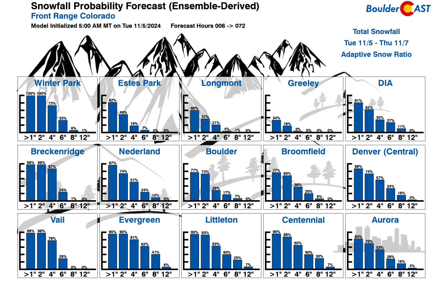
Our Snowfall Probabilities remain pessimistic for much accumulation in the Metro area — there’s only a 80% chance to see more than 2″ of snow in the coming days. However, that 30-40% chance for higher totals is a concern, especially this late in the game.
From a pattern recognition standpoint of the storm being so far southwest, and given everything we are seeing in the global and short-range models, we still believe this storm will favor the Palmer Divide under northerly flow. Our snowfall forecast map through Wednesday night is shown below. This is a borderline non-event for the far northern Front Range (sorry Fort Collins!), including far northeast Boulder County. The far southern Metro area can expect up to 7″ of snow with travel impacts expected on Wednesday. Up to 10″ could fall in the Foothills of Jefferson County, perhaps stretching as far north as Nederland, and atop the Palmer Divide. Some places are still yet to see any snowflakes this season, including Denver’s official climate station (DIA), but that should certainly be rectified in the next 48 hours!
Storm Timeline:
- Tuesday: A mix of clouds and sun with highs in the lower to middle 50s.
- Tuesday night: A cold front moves through with temperatures falling below freezing. Light snow or flurries develop across the area. Accumulations of a dusting to 4″ possible by sunrise, focused south of Denver.
- Wednesday: Intermittent light snow or flurries through the day with light additional accumulation. Better chances to see 1-3″ of snow stick well south of Denver and in the southern Foothills. Highs only near the freezing mark. Travel should remain mostly OK, but watch for slick spots south of Interstate 70. The Palmer Divide could be very dicey Wednesday morning!
- Wednesday night: Any lingering snow should taper off leaving behind cold temperatures in the 20s. If your area somehow hasn’t had a hard freeze yet, it will happen this night with temperatures falling into the lower 20s and even some teens! There is a slight chance that our light, meager snow chances will still be around through the night and into Thursday under weak northerly flow, but we’re leaning towards drying Wednesday night and Thursday.
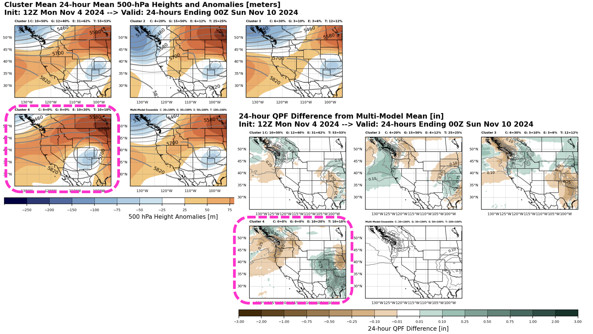
Looking even further ahead in time, some models were previously showing a powerful storm forming across eastern Colorado late on Friday or Saturday as the low pressure in Arizona ejected eastward into the Great Plains. As time has progressed, this solution has become an definite outlier, meaning the odds of it happening are low. The latest cluster analysis shows only about a 10-20% chance of this happening (Cluster #4, pink box below). Pretty much only the Euro modeling suite has any traces of this outcome left. For what its worth, that is typically the most performant model. If this scenario did unfold, our area could see a period of heavy snow on Saturday with blizzard conditions possible east of Denver. Right now the most likely outcome has things spinning up too far south and east of the Front Range with cold but quiet weather Friday into Saturday. We’ll keep an eye on this storm as well, but for now, it too seems like it’ll be another swing and a miss…
Be sure to follow us on Twitter, Facebook, and Threads for impromptu weather updates in the coming days, or subscribe to get notified of our long-form updates here. Enjoy the chilly week and the dash of snow that will accompany it!
Get BoulderCAST updates delivered to your inbox:
Daily Forecast Updates
Get our daily forecast discussion every morning delivered to your inbox.
All Our Model Data
Access to all our Colorado-centric high-resolution weather model graphics. Seriously — every one!
Ski & Hiking Forecasts
6-day forecasts for all the Colorado ski resorts, plus more than 120 hiking trails, including every 14er.
Smoke Forecasts
Wildfire smoke concentration predictions up to 72 hours into the future.
Exclusive Content
Weekend outlooks every Thursday, bonus storm updates, historical data and much more!
No Advertisements
Enjoy ad-free viewing on the entire site.
Enjoy our content? Help us out and give it a share:






You must be logged in to post a comment.