Through the day yesterday, models trended slightly warmer for the storm system as it targets northeast Colorado Monday evening and night. We had hoped that the overnight model runs would reverse these changes, but this unfortunately does not appear to be the case. In lieu of this, we are left with a warmer overall storm…one which has numerous sources of lift and plenty of moisture to squeeze out significant precipitation across the Metro area, but is lacking in the cold air department. This will ultimately make for a very tricky forecast across the Boulder and Denver area this evening and tonight. We discuss our concerns, potential impacts, and provide our snowfall forecast map.
Help support our team of local meteorologists, get expert Front Range weather analysis from us every single day and access to all our forecast content with BoulderCAST Premium. Through April 30th, save 25% on BoulderCAST Premium with discount code SNOW. [Sign up now]
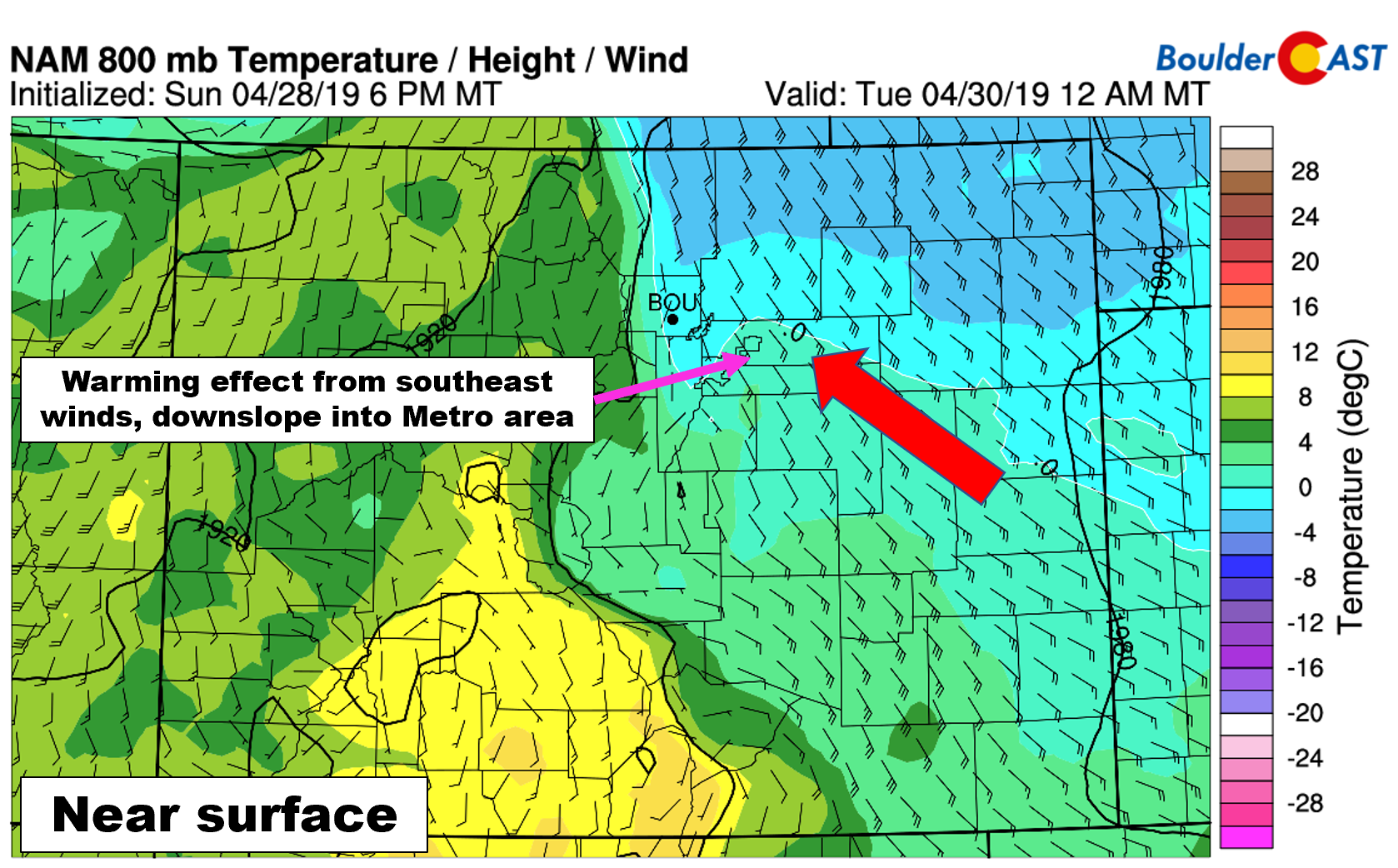
As we discussed in our forecast update yesterday, low-level winds are going to be an issue, more so now than ever considering the marginal temperatures. The models have been advertising this flow all along, so there are no surprises here. This is something that has always concerned us in regards to the snow potential with this storm. The problem with southeasterly flow is that not only is it coming from a warmer region (the south), it is also downslope as the air descends into Denver from the Palmer Divide (7000 feet down to 5200 feet). As a result of these southeasterly winds, localized lift suppression and warming are likely to be an issue for south and east Denver as the storm dumps on the Metro area. Rain or a rain/snow mix will likely hold longer in these areas, limiting potential snow accumulations.
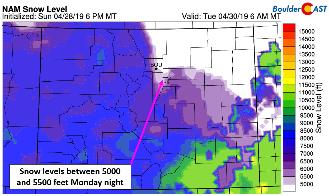
Our latest calculations show snow levels bottoming out somewhere between 5000 and 5500 feet elevation across the immediate Metro area tonight. The highest levels and thus warmest temperatures will be east of Interstate 25 and south of Interstate 70. The Boulder area should be outside the reach of the downslope effects, which is one reason our forecast will include higher snow amounts heading north and west in the Metro area.
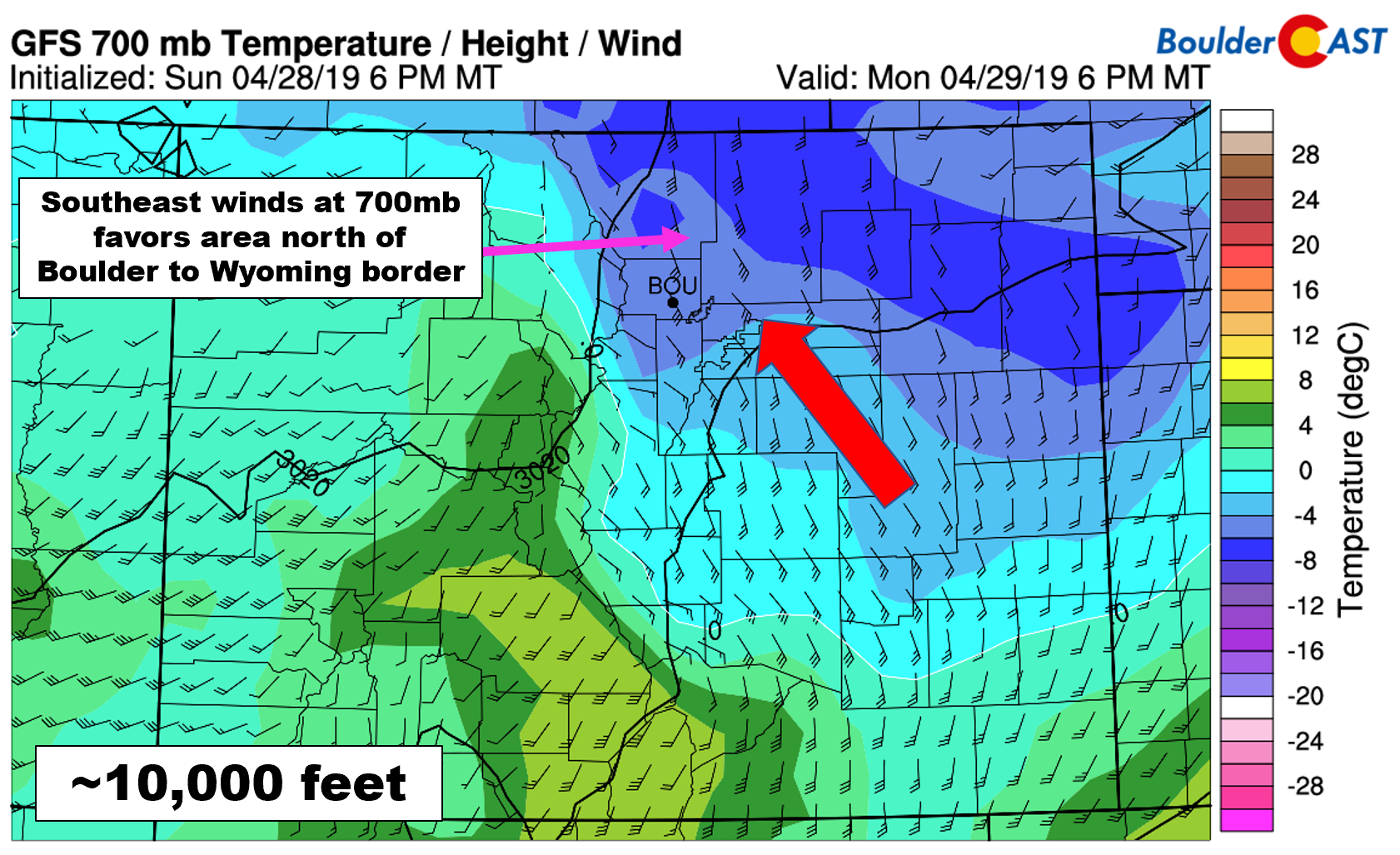
Moist southeasterly winds won’t just be confined to the surface. We’re expecting deep and strong southeasterly flow all the way up to around 600 mb (15000 feet), if the GFS is to be believed that is. This will be a very efficient upslope for areas in and near the Foothills north of Boulder and into Larimer County. These areas are very much favored by this wind direction. As a result, we are anticipating to see the biggest snow totals in the higher elevations in these locations (possibly more than a foot).
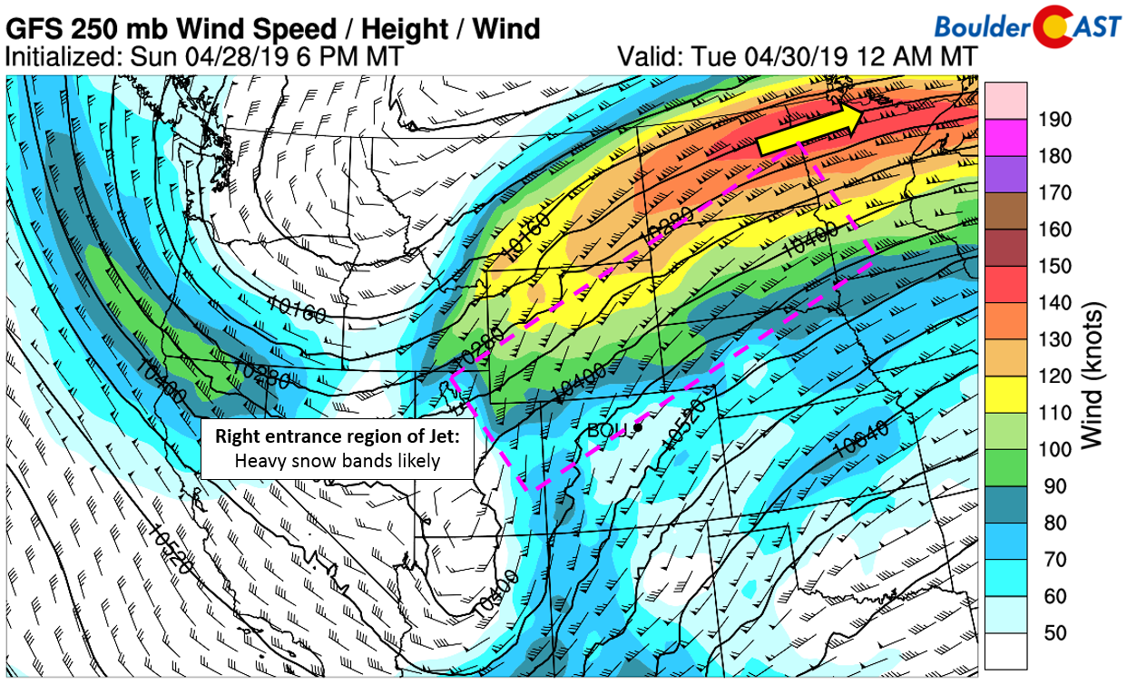
Another aspect of the storm that deserves mentioning is the decreased potential of jet-forced snow bands developing Monday evening into the early morning hours Tuesday. The core of the enlarged jet streak in question is actually located all the way in North Dakota. However, due to its size, portions of Wyoming and even northern Colorado will be in the right entrance region of this jet streak throughout the duration of the storm. It’s a bit of a stretch to include Denver (and maybe even Boulder) in this region though. The best model support for banded snow is north of Boulder, through Fort Collins, and into southeastern Wyoming. We’re not as concerned as we once were about these heavy snow bands potentially clobbering the Denver Metro area.
So where does this all leave us?
Well, it’s not all bad news. We have a very well organized, moisture-rich spring storm headed our way with significant precipitation in the pipeline, especially for the western suburbs and Foothills.
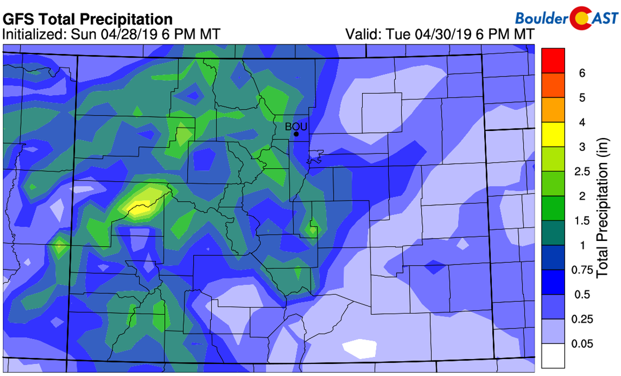
The GFS is showing less than 0.5″ of precipitation east of Interstate 25, with 0.5 to 1.5″ west of Interstate 25. This general distribution is well-supported by all of the models, which makes sense given the focus of upslope and instability across the higher terrain. The Euro model indicates totals just a little lower than the GFS, but the same exact pattern.
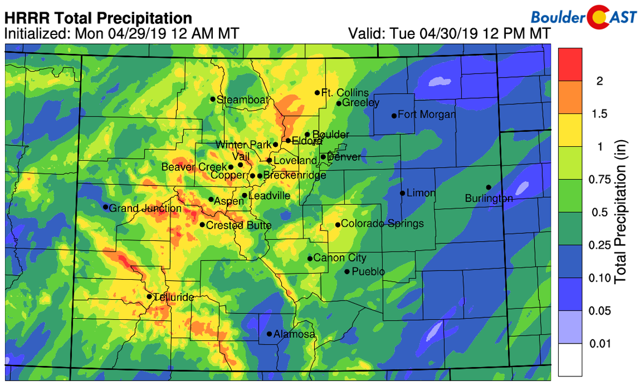
The high-resolution HRRR model has a similar amount of precipitation and distribution across the region. However, there is a clear northern bias with higher precipitation totals spreading eastward along the Wyoming border. This is likely the result of enhanced upslope due to southeasterly flow hitting the Cheyenne Ridge and this area catching a few jet-forced heavy snow bands Monday night.
Potential snow amounts
As is almost always the case with these very late-season snow events, predicting actual snowfall accumulations for the lower elevations is extremely difficult. On one hand, most the heavier precipitation will occur during the overnight hours, which is good, and about the only way you can get accumulating snow during the final days of April. However, southeasterly flow is usually devastating for snow-lovers. We don’t even like to see southeasterly winds during snowstorms in the heart of winter, let alone this late in the snow season.
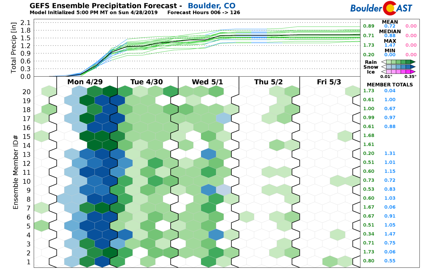
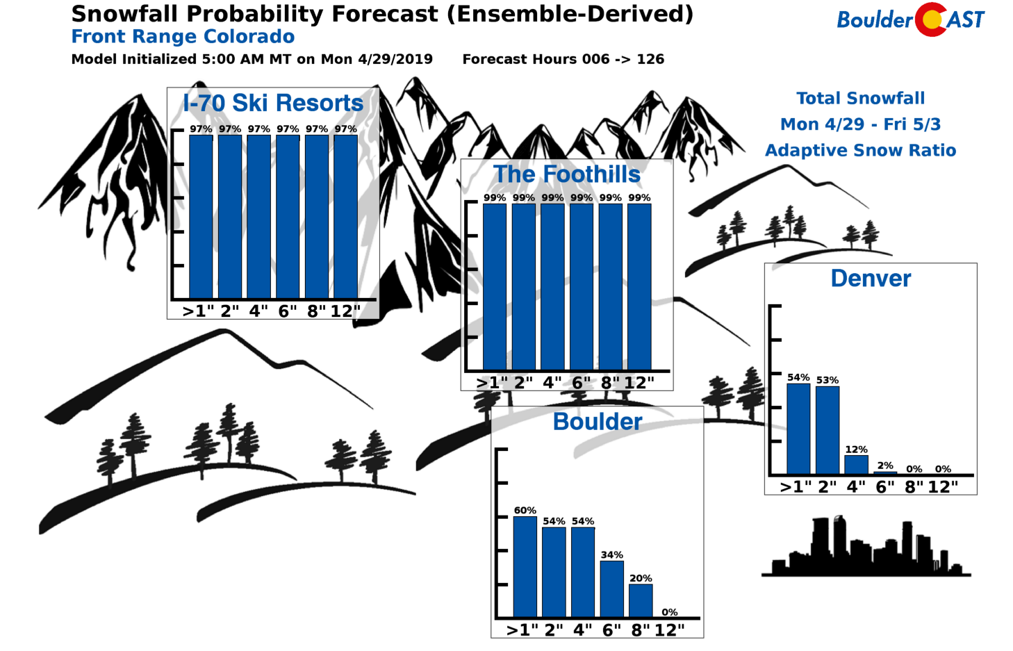
We now see about 20% of GFS ensemble members predicting no snow at all in Boulder (see below). This is the low-end scenario that we are unfortunately NOT able to rule out at this juncture. There is about a 1-in-5 chance of rain only or wet snow that doesn’t stick.
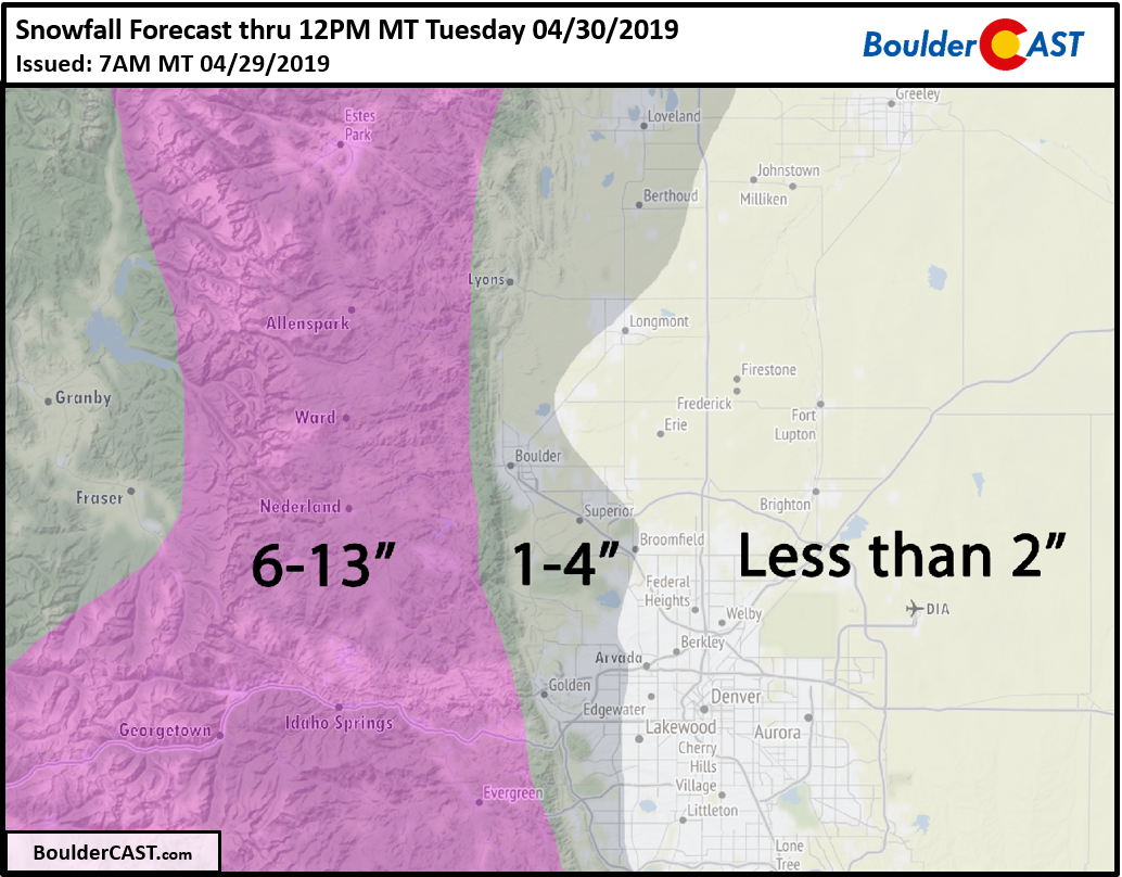
Needless to say, this is far from an ideal set-up for a Boulder/Denver snow event and overall uncertainty is rather high for the lower elevations which are right on the cusp of rain and wet snow. Though temperatures are marginal, we do believe there is enough going for this storm to turn rain to snow across the entire Metro area. Boulder will probably see the most snow out of any lower elevation location (save for Fort Collins). Areas above 6500 feet elevation will be cold enough for all snow and thus we have much higher confidence in snow totals there, which could exceed a foot.
Our snowfall forecast map through mid-day Tuesday is shown below.
Timing, impacts, and uncertainty:
Monday will be a cold and dreary day across the Front Range. Highs will top out only in the 30’s with low clouds lingering through the day. Scattered snow showers will begin to form by late morning and through the afternoon across the higher terrain, moving eastward into the Boulder and Denver area. These showers will be a mix of rain/snow with no accumulation expected given the mild temperatures and late April sun. While the evening commute will be affected by rain or wet snowflakes, roads will be just fine with no real impacts or issues expected.
As all of the ingredients come together this evening, widespread precipitation will develop across the Metro area and continue through much of the overnight hours. With strong dynamics and the overhead jet in-play, there will embedded pockets of moderate rain and snow. Temperatures will be cooling through the evening into the low to middle 30’s with the odds hedging more towards snow than rain region-wide through the evening hours. As we discussed, areas south and east of Denver will have the most trouble turning to snow and even accumulating the snow that does fall. North and west of Denver towards Boulder will do best from this storm. A shift in temperatures by a degree or two either way means more or less snow, depending on the direction of such a shift. We can’t stress this aspect of the forecast enough!
Our Snowfall Probability Charts reinforce our thoughts for this event. Both Boulder and Denver are showing a 50-60% chance of reaching 2″ of snow. Denver drops off rapidly thereafter, but Boulder’s odds remain greater than 20% up to 8″ of snow. If there is anywhere that can bust high from this storm, it will be in and around Boulder!
Here is a summary of the various outcomes for this storm across the Plains, along with a chance of each happening in our expert opinion:
- The low-end scenario (30% chance): Temperatures end-up just a hair too warm and only a few wet snowflakes are reported and no accumulations more than a dusting across the region.
- The high-end scenario (10% chance): Temperatures turn out a few degrees cooler and nearly all of the precipitation falls as heavy wet snow. Snow amounts then range from several inches of slush in Denver to more like 8 to 10″ in Boulder. This outcome could be devastating to trees with advanced foliage.
- Most likely scenario (60% chance): A couple slushy inches or less for everyone, following in-line with our snowfall forecast map. Boulder still does best.
.
Ground temperatures are very warm and air temperatures will remain near-freezing at worst during the storm for most of the Plains. Whether or not it’s rain or a very slushy snow likely won’t matter all that much (unless that high-end scenario verifies). Roads will remain just wet or at worst slushy Monday night. Our high temperature on Sunday was nearly 80 degrees after all! Tuesday’s morning commute should be just fine, except if your route includes areas above 6500 feet elevation.
Snow will wind down for the Front Range in the early morning hours Tuesday, likely before sunrise. Temperatures will climb back into the 40’s on Tuesday with afternoon/evening snow showers developing across the higher elevations, some of which could spread eastward into the Denver Metro in the form of rain or a rain/snow mix.
We’ll most likely provide a storm update this evening for our Premium subscribers with a discussion of our final thoughts and a review of the most recent model runs. Remember, every degree matters for this one!
Help support our team of local meteorologists, get expert Front Range weather analysis from us every single day and access to all our forecast content with BoulderCAST Premium. Through April 30th, save 25% on BoulderCAST Premium with discount code SNOW. [Sign up now]
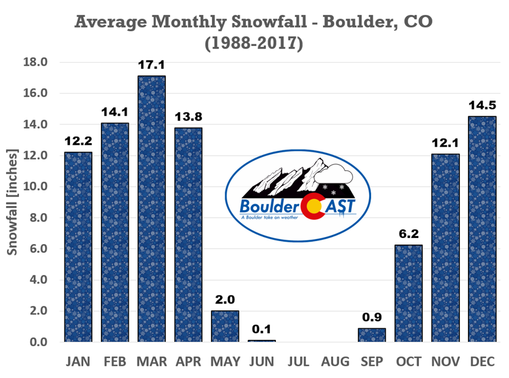
Will this be our last snow of the season? Climatology says that more than likely “YES!” this is the last of the snow. However, as you know, Boulder is far from a stranger to frozen precipitation in May.
Help spread the word! Share our forecast:
.





You must be logged in to post a comment.