
The arrival of our next winter storm is nearly upon us, but a lot of questions remain in the forecast, especially for the western portions of the Metro area. In this update, we discuss the timeline of the storm, lingering concerns about temperatures and downslope, where blizzard conditions will exist, and provide our snowfall forecast map.
GENERAL SETUP
We’ve been tracking this particular snowstorm for more than five days now. The weather models have remained remarkably consistent with this one, both in regards timing and intensity, as well as the location of the heaviest snow and blizzard conditions (to some degree). The wintry weather that is about to unfold is actually the result of two storm systems merging right over Colorado. The “warm” system, which has most of the energy and moisture, is currently positioned in northwestern Mexico and southern Arizona. This is the primary storm which will be tracking into extreme southeastern Colorado by Wednesday evening. We also have a weaker, secondary storm system coming ashore today in the Pacific Northwest. This one will be supplying the cold air to change the rain to snow across the Front Range Wednesday morning, and will be a key factor in determining the exact location where the surface low develops in eastern Colorado.
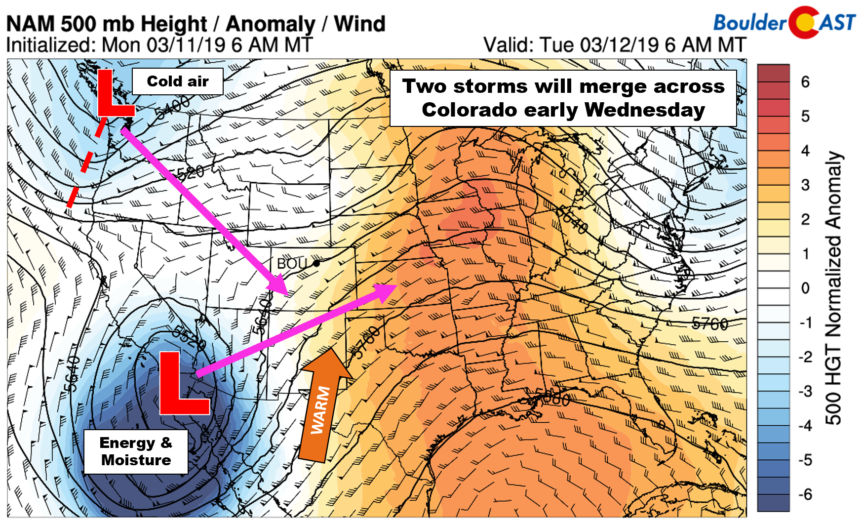
GFS 500 mb height anomaly forecast for Tuesday morning.
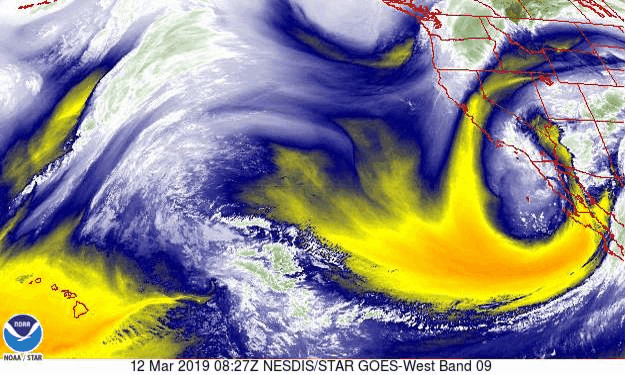
The GOES-West water vapor animation from this morning shows both storm systems coming ashore; the cold/weak disturbance near the Canadian border, and the warm/stronger system near the Mexican border.
As the primary storm system moves towards our state late Tuesday night, explosive lee cyclogenesis will rapidly spawn a potent surface low in southeast Colorado Wednesday morning, one that could be the strongest to ever exist in Colorado. At its peak, the central pressure will reach as low as 972 to 976 millibars, comparable to that of a Category 2 hurricane. As you might expect, winds across most of eastern Colorado will be roaring during this event….hence the near-certainty of blizzard conditions east of Denver. The pressure field is not as compressed in these mid-latitude storm systems as it would be in a hurricane, so winds won’t be nearly as strong. Still, some models are indicating that gusts of 80 mph will be possible out across the farmlands of eastern Colorado. Winds will be a little tamer towards Denver and Boulder, but still intense enough to produce significant drops in visibility when combined with falling snow.

GFS precipitation and sea-level pressure forecast for mid-day Wednesday
The exact positioning of the low pressure is still somewhat unknown, which creates a slew of challenges for this forecast that stem from the complex topography surrounding our area…
Strong northerly winds on the backside of the low pressure will be pulling in the colder air to turn rain to snow across the Front Range during the morning hours Wednesday. The coldest air will likely flood into the eastern Metro area first, with downslope flow and lingering low-level mild air keeping things slightly warmer across the western Metro area. The GFS 800 mb temperature map below shows this nicely. The GFS model is predicting near-surface temperatures in the upper 30’s in Boulder at 12PM Wednesday (not good for snow)! We think this is a little too warm, but it does show that temperatures are going to be a real issue near the base of the Foothills.
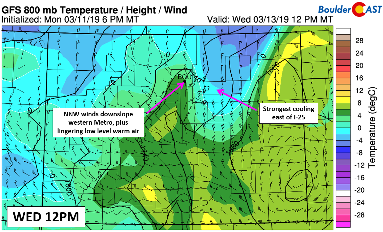
GFS 800mb temperature and wind forecast for mid-day Wednesday.
Furthermore, wind direction is also going to be an problem for these same areas. As we expressed concern for in our outlook on Monday, despite the surface low being located in southeast/south-central Colorado, a seemingly prime location, its utter intensity and size mean the region of best upslope will end up well north of the Front Range in Wyoming. There is essentially no upslope in the pipeline for Boulder or Jefferson Counties. Even worse, the very strong winds wrapping into the low pressure (50 to 70 mph at 700 mb) may have a slight westerly component. This does not bode well for snow amounts west of I-25, particularly towards Boulder and Longmont.

NAM 700 mb temperature and wind forecast for Wednesday showing north-northwest winds in place across Metro area.
Timeline
- As the initial pulses of moisture and lift arrive ahead of the main storm system, we expect rain showers to begin developing Tuesday evening and continue towards sunrise Wednesday. Some CAPE will be present at the onset, which will mean convective showers and possibly a few lightning strikes.
- As the potent surface low develops across east-central Colorado Wednesday morning, colder air will be drawn southward into our region, turning rain to VERY heavy snow through the morning hours. The change-over will likely happen from east to west, with areas near Boulder and Longmont taking the longest to change-over, possibly as late as early afternoon.
- Moderate to heavy snow will continue for much of the afternoon and early evening hours across the Boulder and Denver areas. Snowfall rates could easily hit 1 to 2″ per hour late Wednesday morning and into the afternoon when the most intense lift is near and just east of Denver. However, as lift from the storm pulls eastward and strong northwest downslope takes hold, we should see snow quickly simmer down west and northwest of Denver. Winds will be strong through the daytime hours. Look for gusts of 35 to 50 mph near Boulder, and upwards of 50 to 70 mph out near DIA. All this wind combined with the snow could create “blizzard-like” conditions in the Metro area at times mid-day into early evening. Absolutely expect delays/cancellations of flights to and from DIA.
- Snow will taper off west to east through the evening, wrapping up for just about everyone before midnight Wednesday night
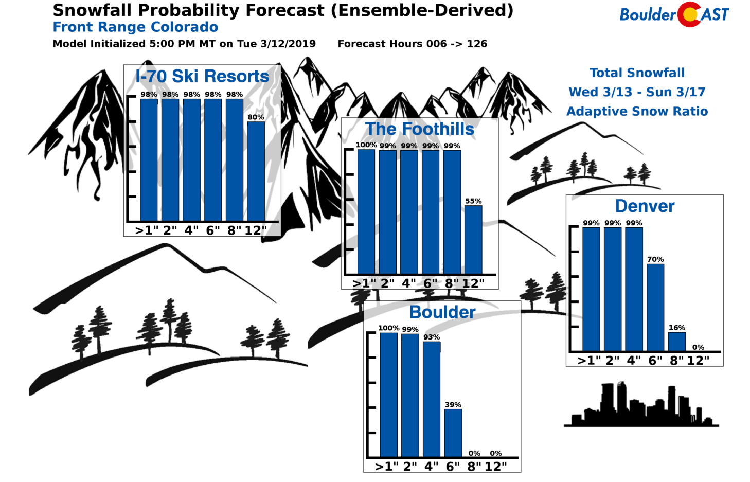
Snow amounts
While this storm system will likely explode into the strongest ever to exist in Colorado, snow totals across the Front Range will ultimately be hampered by the storm’s quick progression and warm temperatures early on. The incredible lift and cold air will only overlap across our region for a short period of time.
The combination of a late change-over to snow and a shift to downslope will greatly limit this storm’s snow potential around Boulder. There may only be a handful of hours with accumulating snow. We’ll also be fighting the mid-day March sun and warm ground temperatures which will lead to additional melting. Areas near and east of Interstate 25 will indeed see higher snow totals, with snowfall beginning earlier, ending later and being more intense overall. Thus, we expect a relatively sharp gradient in snow amounts west to east across the Metro area.
Here is what the major models are showing for liquid amounts as of their Tuesday morning runs:
- GFS: Boulder 0.6″ / Denver 0.9″
- GFS-FV3: Boulder 1.0″ / Denver 1.2″
- NAM: Boulder 1.1″ / Denver 1.5″
- Euro: Boulder 0.9″ / Denver 1.1″
- 3KM-NAM: Boulder 0.2″ / Denver 0.7″
- GFS Ensembles: Boulder 0.4-0.6″ / Denver 0.5-0.9″

As a result of small uncertainties in the low pressure’s location and those warm temperatures, we’re still not very confident in snow amounts for this storm. We know snow will be heavier in Denver compared to Boulder, but to what extent is not clear. Raw liquid amounts suggest possibilities range from a near “non-event” in Boulder to more than an inch of liquid in Denver, much of which could fall as heavy wet snow. We could really see things going either way right now. In fact, this storm bares a lot of similarity to a snowstorm that busted quite extravagantly back in November of 2015.
Our current thoughts on amounts are summarized in our snowfall map below.
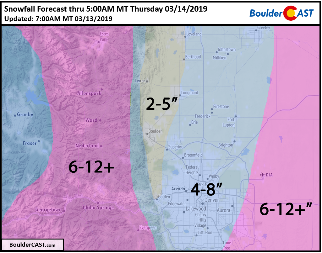
So yes, more snow east, less west (perhaps much less)….a reverse of what we normally have across our area. The snowfall probabilities show the potential for a low-end bust in Boulder is elevated, while the potential for higher amounts does exist in Denver.
Denver Forecast Confidence:
Boulder Forecast Confidence:
With convective rain changing to heavy snow and a dash of hurricane-force winds blowing it all sideways, the weather on Wednesday across eastern Colorado will be one to remember. While the worst conditions will be well east of our area (e.g. watch out for interstate closures and power outages), widespread snow and wind will cause moderate travel issues throughout the Metro area Wednesday afternoon into the evening.
Depending on what we see from the model runs Tuesday evening, we may need to touch up the forecast.
Check back for updates or subscribe:
We respect your privacy. You can unsubscribe at any time.
If you’re a Premium member, we talked in greater detail about the forecast specifics and challenges in a 20-minute video earlier today. Find that HERE.
Get expert Front Range weather analysis from our team every single day and access to all our forecast content with BoulderCAST Premium.

Spread the word! Share our forecast:
.


You must be logged in to post a comment.