A strong Pacific storm system will spread snowfall across the state of Colorado over the next 24 to 36 hours. Impressive snow totals will be possible in the Mountains, with lighter but still noteworthy accumulations expected across the Denver Metro area. We discuss the atmospheric components coming together, likely snow amounts, and the impact on Wednesday’s evening commute.
PREMIUM STORM UPDATE (WED 02/06 7:00 AM): Read HERE.
U
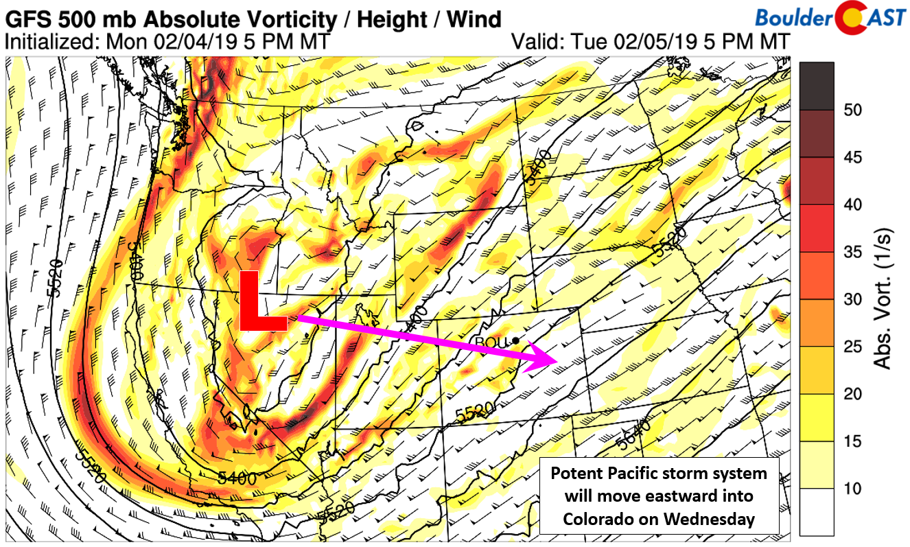
nlike last week’s “surprise” snowstorm that dumped up to a foot of snow in some Front Range cities, this time we have a solid bead on the wintry system trudging towards Colorado this evening. The strong Pacific low-pressure system came ashore into California this morning and is currently located in northern Nevada. It will be taking an “in-between” track eastward into Colorado over the next 24 hours, right across the crest of the Rockies. This system dumped more than 2 feet of snow in the Sierras and had at least one rotating thunderstorm drop a funnel cloud in central California on Monday.
The most important aspect of this snowfall event will likely be the inter-play between moist southwest flow in the mid-levels of the atmosphere ahead of the trough, and the bitter cold surge of Arctic upslope coming into the Metro area at the surface. The GFS forecast maps below show these competing forces during the day Wednesday.
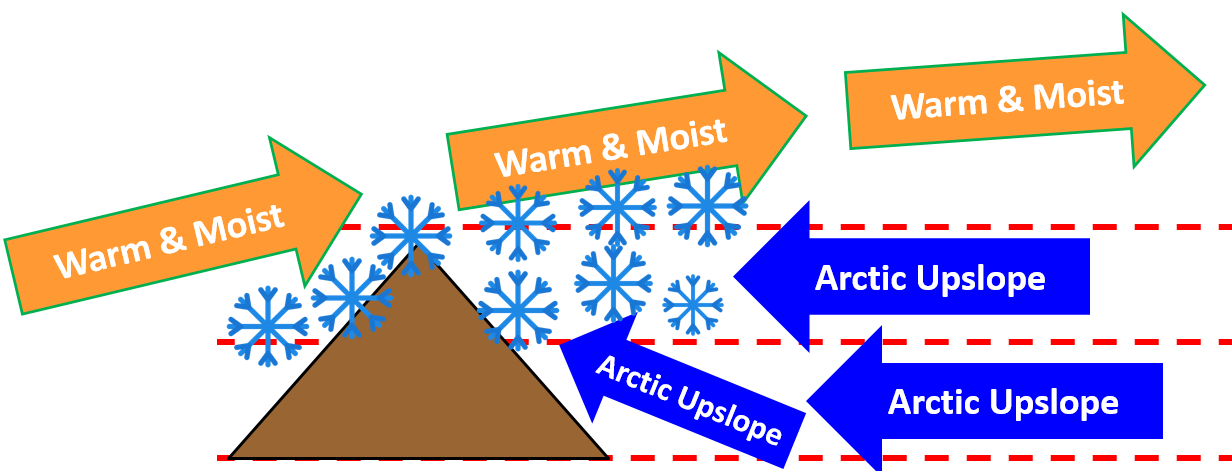
This set-up is called over-running, and isn’t always a factor in our snowfall events. It just so happens that the storm’s track will favor it this time with a period of southwest flow. An idealized diagram of over-running in Colorado’s Front Range is shown below.
The upslope alone will be strong enough AND deep enough to produce widespread snow Wednesday afternoon, evening, and night across most of the Metro area. The over-running will worsen things and help to fuel more moderate snowfall north of Denver towards Fort Collins. These areas will likely see the most snow.
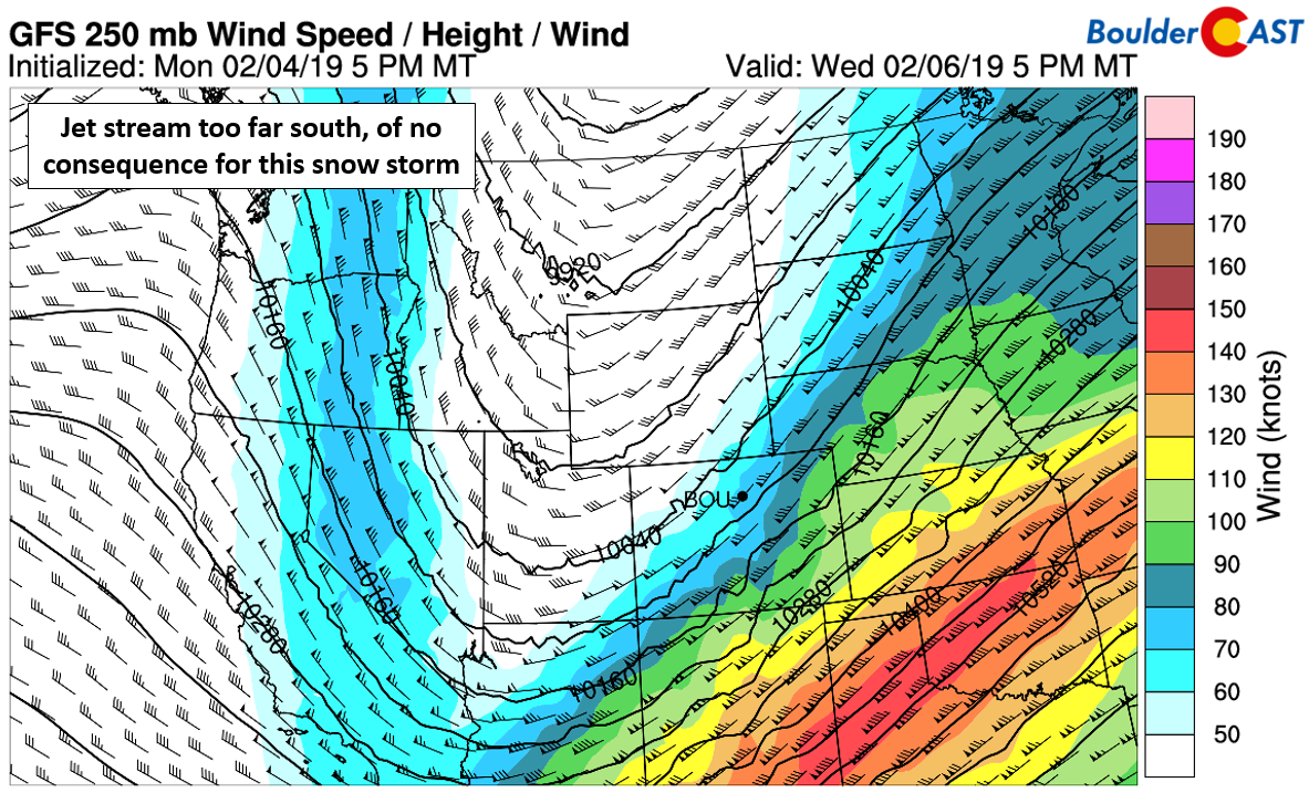
Unlike our last dumping (and several others this winter), the jet will be a no-show for this particular storm. It will already be too far south by the time the Arctic air and trough arrive.
The timeline for the storm is shaping-up like this:
- The leading edge of the Arctic air pushes southward through Boulder and Denver sometime Wednesday morning. Temperatures will initially be relatively mild, in the lower 30’s beforehand. This will quickly change though with tumbling temperatures through the day into the teens and eventually approaching ZERO degrees late Wednesday night.
- Moderate to heavy snow showers are expected to quickly materialize by late morning or early afternoon and continue through Wednesday evening’s rush hour. The over-running will be present only for the first six to eight hours of the event. After this, drier northwest flow will filter in aloft which will leave only upslope and large-scale ascent from the trough to keep snow going in the Metro area.
- Light, to at times, moderate snow will continue across much of the region through Wednesday night, possibly lingering into early Thursday morning for the western and southern fringes of Denver.
- The Arctic airmass will keep its grasp on the region through early Friday. Expect highs Thursday to only top-out in the teens, with lows again dropping to near zero Friday morning.
Snow amounts
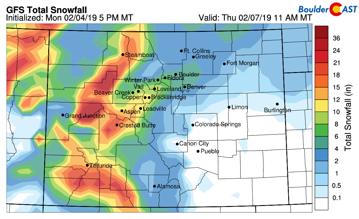
The set-up at hand will undoubtedly favor the Mountains with an extended period of moist southwest flow likely to produce 10-20″ for the higher peaks and ranges.
Both Wednesday and Thursday will be excellent ski days as a result. Most resorts stand to see 6 to 14″ by Thursday morning, with locally higher amounts definitely on the table.
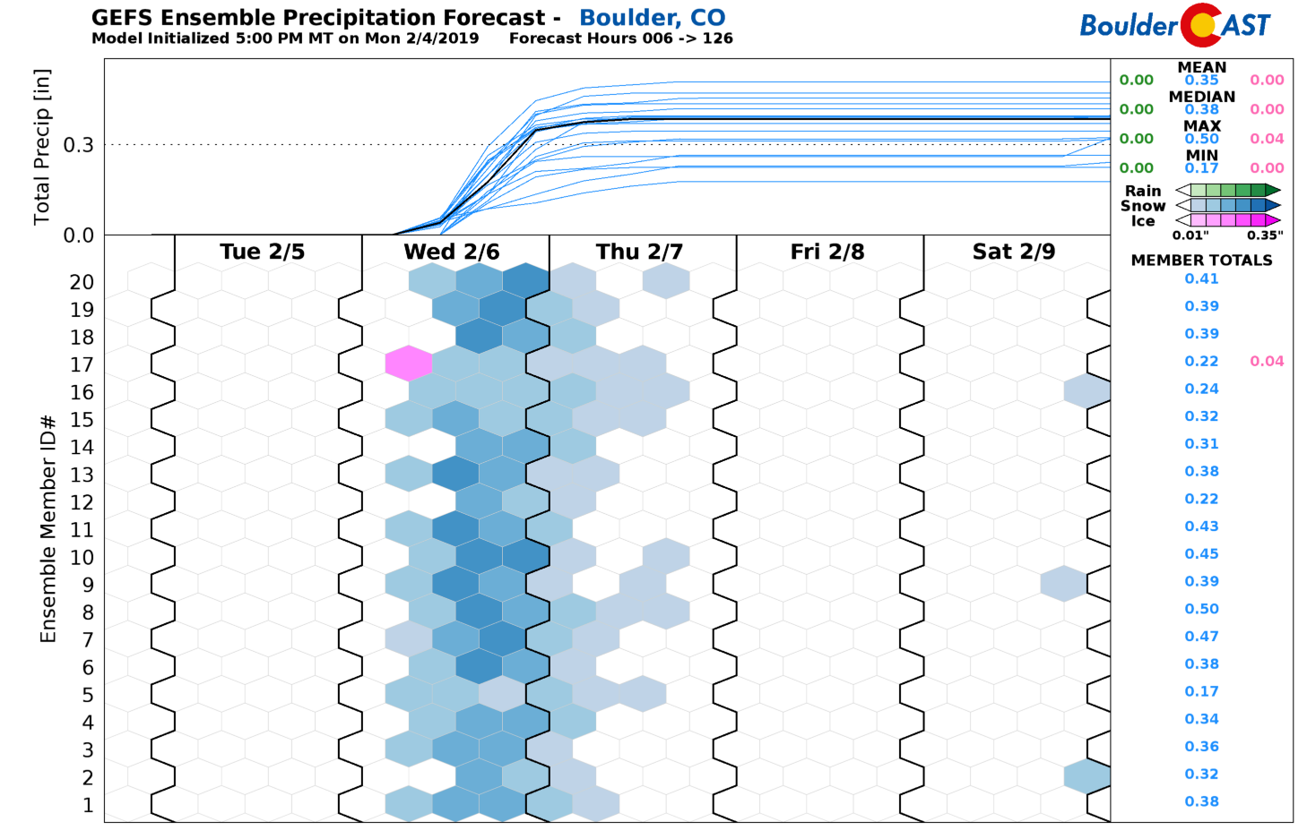
East of the Mountains, snow amounts will be lighter, but still quite respectable. We want to stress that there is good agreement between all of the models right now. This has been the case for the last few days, so our confidence in the overall forecast is up there. The global and regional models have been favoring north and west of Denver all along. With the higher resolution models starting to get a look at the storm, we’re seeing the same trend there as well. Thus, we expect the largest totals to be north and west of Denver towards Boulder, with lower amounts across the eastern and southern portions of the Metro area. Here is what we are seeing for (liquid) precipitation totals right now in the various models:
- NAM: 0.2″ to 0.5″
- High-res NAM: 0.15″ to 0.45″
- GFS: 0.2″ to 0.45″
- Next-gen GFS: 0.25″ to 0.45″
- Canadian: 0.15″ to 0.3″
- Canadian Ensembles: 0.2 to 0.3″
- Euro: 0.1″ to 0.3″
- HRRR: 0.2″ to 0.6″
- GFS Ensembles (below): 0.2″ to 0.4″
The very cold Arctic air and good lift and saturation in the snow-growth layer aloft will boost snow ratios for this event. We expect ratios near 15-to-1 at the onset, rising as colder air filters in throughout Wednesday evening and night, probably reaching 20-to-1. Remember, FLUFFY snow yields MORE snow!

GFS model-derived snow ratios for Wednesday evening (left) and night (right). Fluffy snow for everyone!
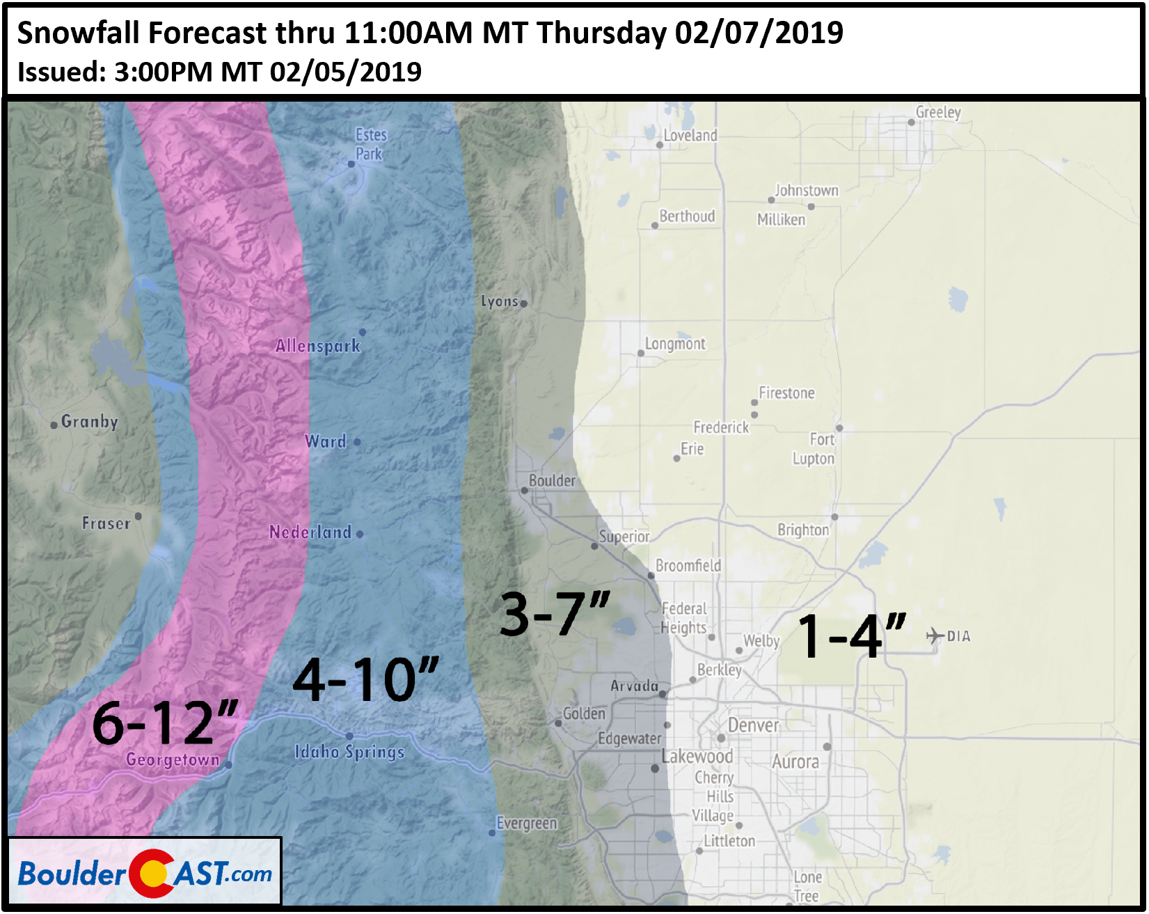
Our snowfall forecast map for the event is below.
Due to the timing of the more moderate snowfall, impacts are likely for the Wednesday evening commute, especially north and west of Denver into Boulder. Leave a little extra time and take it slow! Some lingering slick roads may exist Thursday morning as well given the very cold temperatures in the single digits expected.
Another week, another snow storm. Let’s keep it going, Mother Nature!
Premium Member Notice: Due to the snowstorm, we’ve extended this week’s Weather Quiz period. You now have until Thursday at 12PM to get your answers in regarding “Cold Air & the Stratosphere”.
Help support BoulderCAST by sharing our forecast:
.





You must be logged in to post a comment.