
Lots to talk about this week, but nonetheless, not much changes compared to our recent weather trends. This week will feature a couple cold fronts and a weak system which may bring a few light rain/snow showers to the region. Ultimately, though, the continued storyline for the Front Range is very limited moisture, above normal temperatures, and worsening fire conditions. Continue reading for our complete outlook of the upcoming week.
Warm and breezy for Monday
Fittingly, the last day of October will go out very warm and quiet as Colorado lies within a departing upper-level ridge. This is the same ridge that brought record-heat to the region last week, and beautiful weather this past weekend.
In addition to the exiting ridge, today’s 500 mb vorticity map shows two weak disturbances that will pass mostly to our north early in the week, as well as another potential system the will be impacting Colorado more substantially by mid-week.

GFS 500 mb vorticity map for Monday, showing this week’s weather players.
With moderately strong west-southwesterly winds, today will see warm downslope conditions across the Plains. Expect sunshine, wave clouds, gusty winds, and temperatures in the middle 70’s. This is 15 to 20 degrees above normal for late October, and will push this month further up the list for warmest on record. Despite likely not meeting Red Flag Warning criteria, the fire danger will be HIGH today!
A weak cold front associated with those two small systems to our north will move through this evening from the northwest. This front will be dry and won’t provide much cool-down.
Tuesday will be somewhat similar to Monday. We’ll still be under the influence of dry southwesterly flow aloft, but the overall speed is weaker. Therefore, we’re not anticipating gusty conditions like Monday. On the backside of the cold front, it will be about ten degrees cooler, with highs in the middle 60’s and a good deal of sunshine!
A “real” system by mid-week…just maybe
Some change is on the horizon! The key word, though, is SOME. By Wednesday, that system that was offshore on Monday approaches Colorado. Last weekend’s ridge has pushed into Florida, but is just too powerful to allow the trough to freely move eastward. Consequentially, the fate of the mid-week trough is still not fully-resolved. The GFS model currently has this trough elongating substantially, from Canada, through western Colorado, and into Mexico (see below).
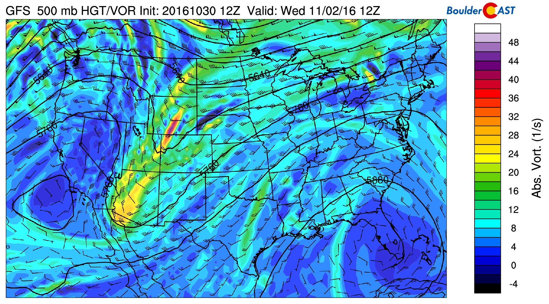
GFS 500 mb vorticity map for Wednesday, showing an elongated trough approaching Colorado
There is good agreement amount the ensembles that this trough will “pinch off” Wednesday. However, exactly how this happens varies from model to model, and run to run.
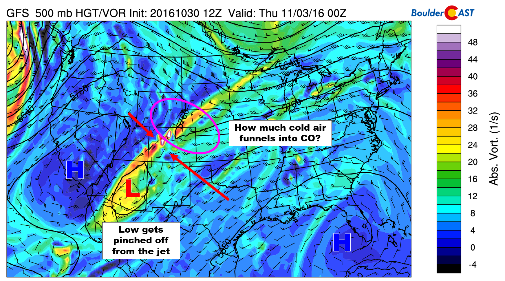
GFS 500 mb vorticity map for Wednesday evening. The trough gets pinched off from the jet by two high pressure ridges, leaving some uncertainty in our forecast
Truth be told, the specifics won’t really matter for us, at least in terms of precipitation. If the main system can dive a little further south before separating from the jet, we could see a slight chance of a few showers Wednesday morning. The real impact will be on our temperatures. Highs could be as cold as low 50’s Wednesday, and as warm as mid 60’s…it all depends how this “pinching” plays out. For now, we’ll stay the middle-ground, and forecast upper 50’s for Wednesday. Just know the uncertainty is rather large. There will probably be some isolated showers around, with snow levels around 8,500 to 9,500 feet.
Check out the neat animation below of the low cutting-off from the jet stream and stalling over Arizona. It gets obliterated from all directions by the mega-ridge!
Moderating temperatures close out the week
As you may have noticed in the animation, the two ridges quickly merge into a solo, formidable ridge for Thursday and Friday, which takes over most of the western United States. With this, we’ll see temperatures on the increase and mostly sunny skies. The remnant system in Arizona will keep the extremely warm air from returning for now, but we should still be able to manage near 70 degrees both days (Friday the warmer of the two).
Enjoy. It looks as though next week could be a little more active, with even some indication for snow! More on this in our November’s outlook tomorrow…
Forecast Specifics:
Monday: Partly sunny, warm and breezy. Westerly winds 10 to 15 mph, with gusts to 30 mph. Winds in the higher Foothills in the morning hours could gust to near 50 mph. Highs in the low to mid 70’s over the Plains, and lower 60’s in the Foothills.
Halloween Evening Forecast: Cool and mostly clear with temperatures generally in the 50’s before midnight Monday evening.
Tuesday: After some morning clouds, skies will be mostly sunny. Highs in the mid 60’s on the Plains with low 50’s in the Foothills.
Wednesday: Partly to mostly cloudy and cooler. Isolated showers will be possible throughout the morning and early afternoon. Some snow could mix in above 8,500 feet with little to no accumulation. Highs will be in the upper 50’s over the Plains with mid 40’s in the Foothills.
Thursday: Mostly sunny and mild with morning frost. Temperatures warmer into the mid to upper 60’s with middle 50’s in the Foothills.
Friday: Mostly sunny and dry. Temperatures near 70 for the Plains. For the Foothills, expect highs near 60 degrees.
High Country: The Mountains will see windy conditions Monday, with gusts above treeline exceeding 60 mph. There will be spotty snow showers for west-facing slopes late Tuesday afternoon into late Wednesday afternoon. Very light accumulations, generally less than 2″ will be possible in favored spots. Mostly sunny weather with light winds returns for Thursday and Friday.
Extended: Model ensembles do show our weather becoming more interesting next week. The GFS has two systems moving through, with some colder air to work with. While this is still too far out to make any definite predictions, the second week of November looks a little better. Still not seeing any powerful storms in the pipeline, though.
Mon
Tue
Wed
Thu
Fri


Temperature
76
66
58
67
69


Precip Chc (Plains)
0%
0%
10%
0%
0%


You must be logged in to post a comment.