
With Independence Day now upon us, summer is in full-swing across the Front Range. We discuss the weather-week ahead (spoiler: it’s going to be hot!), and give our thoughts on when those monsoon rains might finally show up.
Where is the monsoon?
As we enter the first full-week of July, you may be wondering when the summer monsoon is going to make an appearance in Colorado. Our summer monsoon (known more widely as the Arizona Monsoon, or the North American Monsoon) requires a prolonged period of southerly flow to bring moisture-rich air northward to the region. A typical July weather set-up for this to happen is seen below.
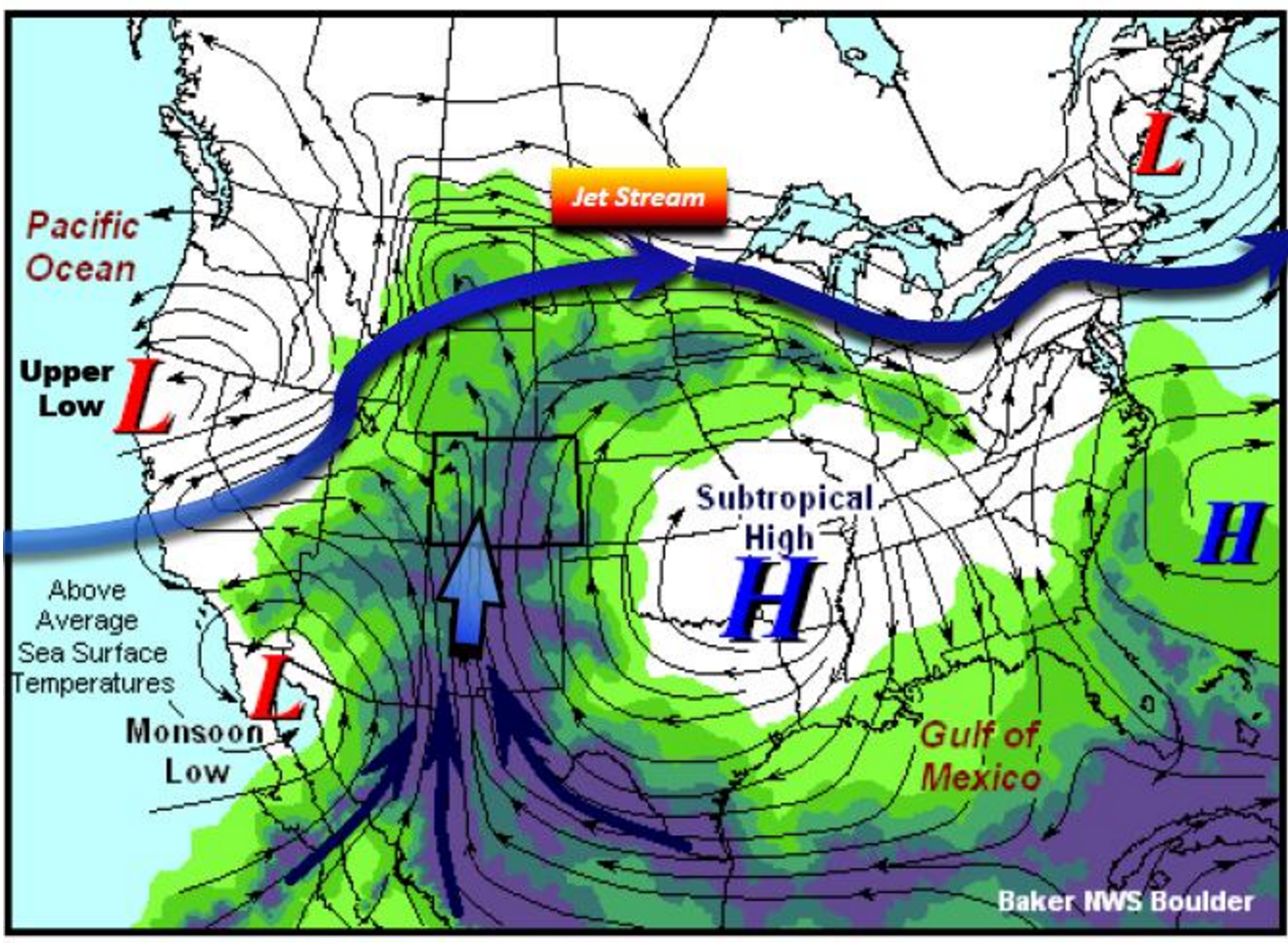
Typical summer monsoon weather pattern
Weather changes in summer occur much more slowly than the rest of the year. This stagnation often gets our monsoon going. Once we get a pattern similar to the one above in place, it can take a week or two for that moisture to fully-propagate into Colorado. As of now, we aren’t seeing much indication of this pattern anytime soon in the ensemble models. As such, those beneficial summer rains could be quite a ways off.
This week in weather: Hot with a few storms
We begin this week, as usual, with a discussion of the large-scale features that will be impacting our weather for the week ahead. Below is the 500 mb vorticity map for Monday afternoon.
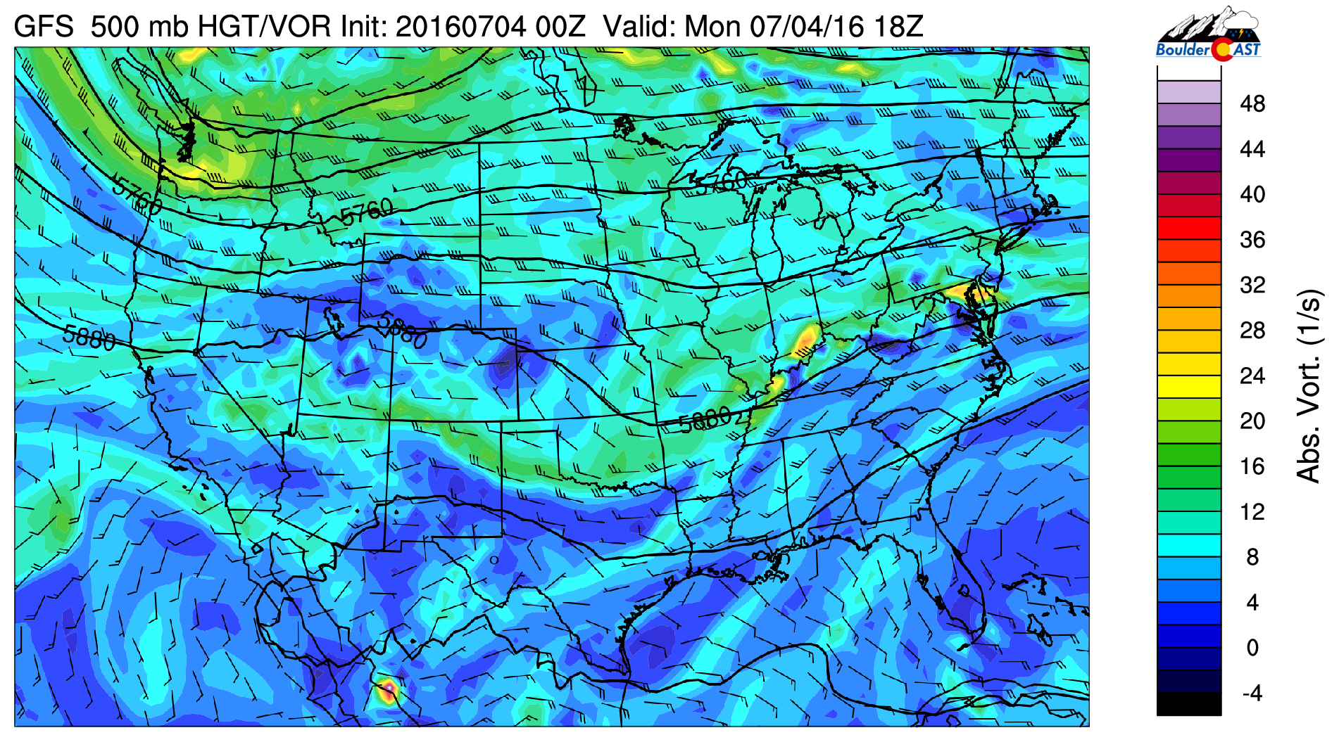
GFS 500 mb vorticity map for Monday afternoon showing a ridge across Colorado
Most importantly, in the immediate area to Colorado, you will notice ridging in place, seen as a bump in the 5880-meter height line. The core of this ridge is over west Texas. This ridging will once again dominate our weather for the week, bringing above normal temperatures and only meager chances of rain. You’ll also notice a trough over Washington state. As hard as it tries, it just won’t be able to make it far enough south to impact our weather significantly. Though, it will bring a cool-down for Thursday.
Beautiful Independence Day
Back to that ridge and the weather for July Fourth!
With this fair-weather pattern in place, today will be mostly sunny early, then partly cloudy as a few isolated storms begin to pop-up in the afternoon and early-evening. The upper-levels are fairly dry, so storm coverage will be minimal and any storms that do materialize should be weak and short-lived. Highs will be in the low 90’s.
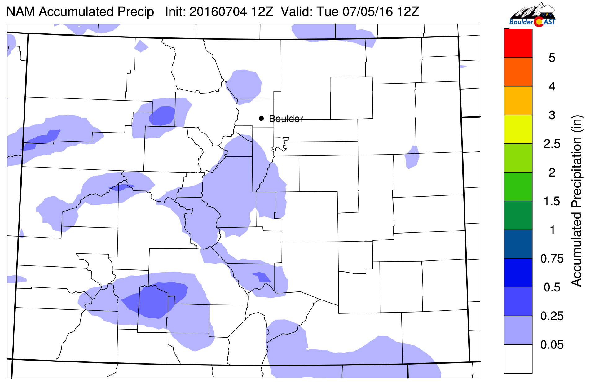
NAM model forecast precipitation for Monday. Light amounts and very spotty for the region
While we expect things to begin to die down after sunset, spotty storms could have an impact on a few firework displays tonight, particularly south of Denver. Though, full cancellations seem rather unlikely given the state of the atmosphere. We honestly couldn’t ask for better weather this time of year!
Tuesday will be nearly identical to Monday. Temperatures will once again be in the low 90’s under mostly sunny skies. It’s hardly worth mentioning, but there is an outside chance of a stray afternoon brief thundershower. Just about everyone should be dry, though.
Bone-dry by midweek
By Wednesday, we see the ridge shift eastward a bit and that trough in the Northwest move slightly closer to Colorado.
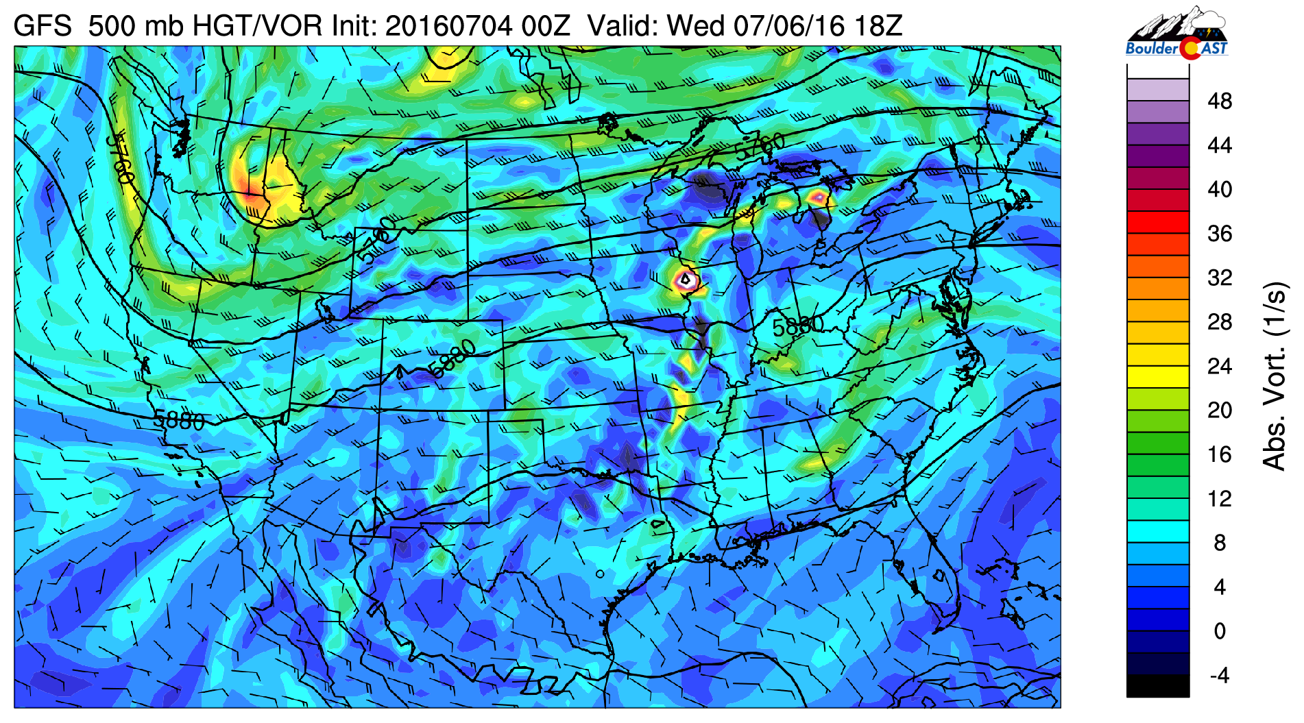
GFS 500 mb vorticity map for Wednesday afternoon. Warm and dry west-southwesterly flow will heat things up for us
The 500 mb winds (seen above) are west-southwesterly at about 30 knots. Usually this wind direction would provide at least some moisture for storms in our area. However, this flow will be extremely dry for this time of year, pushing Boulder/Denver’s precipitable water values down to ~0.3″ (seen below).
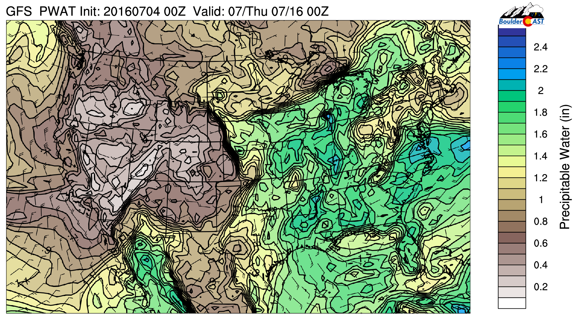
GFS precipitable water forecast for Wednesday. An unseasonably dry airmass sits over Colorado
The complete lack of moisture in our area will produce full sunshine for Wednesday and Thursday. Wednesday will be the warmest day of the week, reaching the mid 90’s for afternoon highs. Thursday will cool-off slightly as a weak cold front moves into the northeast part of the state in association with the aforementioned trough to our north. The timing of this front will ultimately determine how warm we get beforehand. The various models and runs show it arriving anytime between noon to 10PM. This puts highs ranging between 85 and 95. For now, we’ll play the middle-ground and forecast near 90 degrees for Thursday.
Closing out the week, Friday will see plenty of sunshine and remain warm. With a little moisture creeping back into the picture, storm chances inch back up as well. Expect mostly sunny skies with just isolated storms, particularly across the Mountains and Foothills. Highs will be near 90 degrees again.
—
Overall, not a bad week. The emerald mountainsides around the region will slowly be turning brown. Without much hope for those monsoon rains, we expect this continue for the foreseeable future.
Try to stay cool out there this week!
The Forecast:
Monday *Independence Day*: Mostly sunny and warm with only an isolated storm or two in the afternoon and evening. Highs in the low 90’s for the Plains and near 80 in the Foothills. Firework festivities should not be impacted!
Tuesday: Mostly sunny, then a few clouds with isolated thundershowers. Most locations will remain dry. High temperatures in the low 90’s on the Plains, with near 80 over the Foothills.
Wednesday: Full sunshine and hot. Highs in the mid 90’s for the Plains, low 80’s in the Foothills.
Thursday: Mostly sunny and warm. Temperatures climbing to near 90 on the Plains and near 80 in the Foothills. The timing of an afternoon cold front could shift highs 5 degrees either way.
Friday: Mostly sunny with isolated afternoon thunderstorms, particularly across the higher terrain. Highs near 90 on the Plains with upper 70’s in the Foothills.
Extended: Model forecasts indicate that things won’t change much for the upcoming weekend. It looks like temperatures will be in the 90’s with just isolated storms for both Saturday and Sunday.
High Country: Isolated to widely scattered storms will be on-tap for the Mountains both Monday and Tuesday. Wednesday and Thursday will be dry with hardly any clouds. Storms return to the forecast, isolated in nature, for Friday and the upcoming weekend.


You must be logged in to post a comment.