As one would expect during the month of January, our driest month of the year, this week will be relatively quiet across the Front Range. We’re tracking continued Mountain snowfall early in the week, and with a large trough moving in, cooler temperatures will linger statewide through the weekend. Continue reading for our complete weekly outlook.
This week’s weather is front-loaded
For much of the week ahead, a large trough will be in place across Colorado. This will be our biggest weather player and the focus of much of our discussion here. In the 500 mb vorticity map below for Monday night, the huge trough can be seen across the western United States.
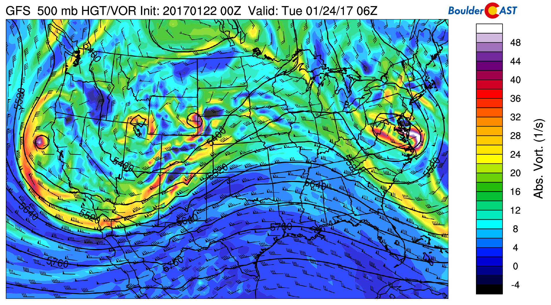
GFS 500 mb vorticity map for Monday night
The are two things of importance here:
- Notice within the larger trough, there are three embedded waves. One in eastern Wyoming, one in southern Idaho, and one just off the California coast. These areas will be focal points for precipitation.
- Colorado will be on the leading edge of this large trough Monday, with strong southwesterly flow that is packed with moisture. This will equate to more Mountain snow!
The downside is that the first two cores of energy will be too far north to bring much impact to the lower elevations in northeast Colorado. The pressure and precipitation map below shows the accompanying surface lows for each piece of energy.
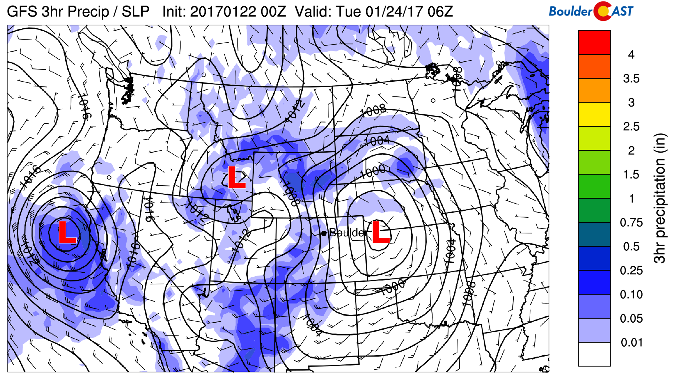
GFS sea-level pressure and precipitation forecast for Monday night. The surface low in Colorado is too far north and favors Wyoming for upslope
With the low forming in northeast Colorado, this will produce downslope east of the Front Range Rockies. Wyoming/South Dakota will see decent snow from these first two systems. Denver…not so much.
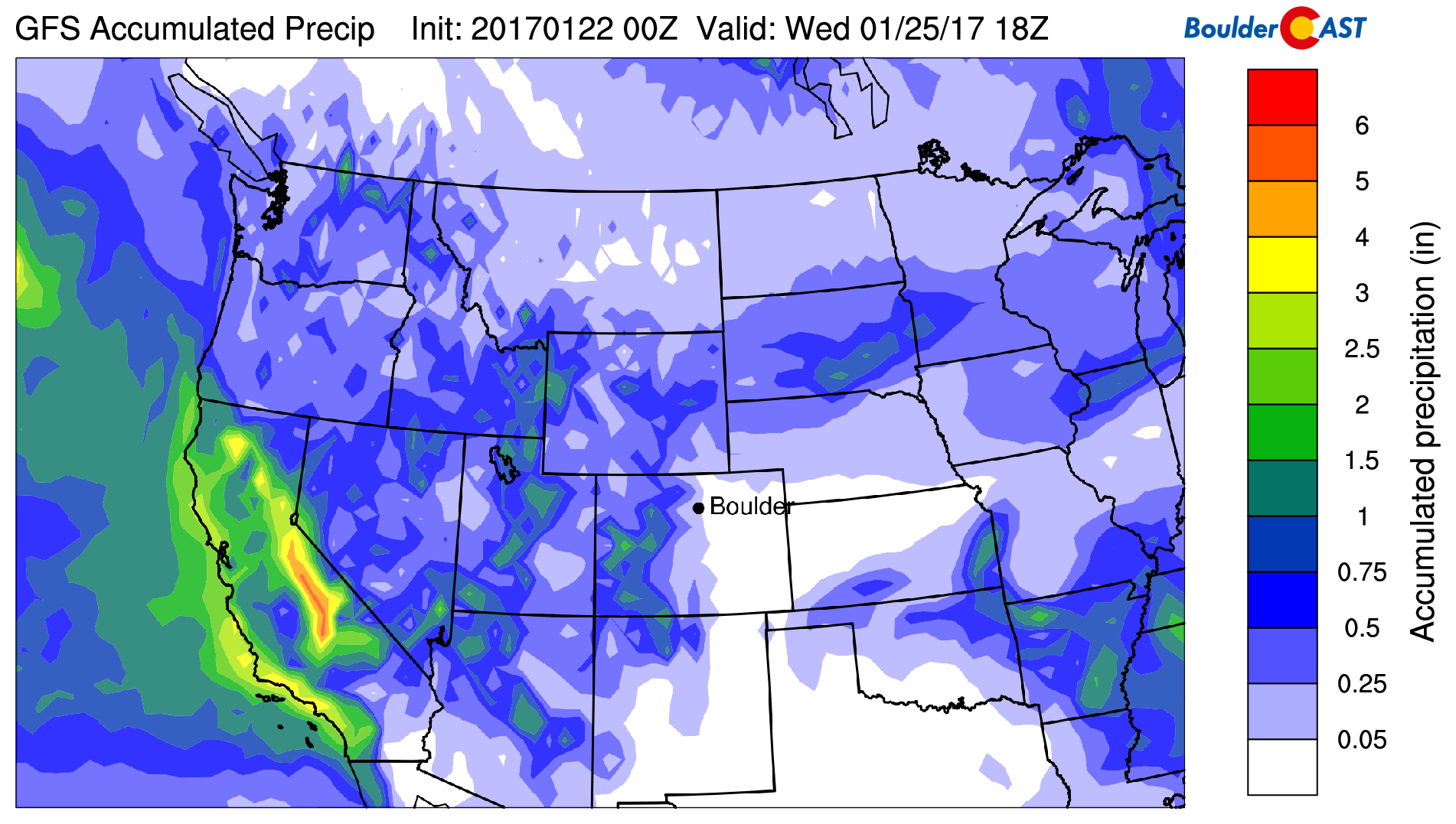
GFS total accumulated precipitation forecast showing most will remain to our north in Wyoming
The Plains will have a warm day Monday, definitely the warmest of the week. Downslope flow will rule with that southerly component mentioned earlier. Highs will likely be in the low to mid 50’s with partly sunny skies. A mix of light rain (Plains) and snow (higher Foothills) will be possible Monday afternoon and evening across the region as some showers roll off the Mountains. Though, with downslope in play, these should be light and not make it too far from the base of the Foothills. Areas near Peak-to-Peak could see 1″ or so of snow through the day.
Snow will generally be light to moderate across the Mountains on Monday, but it will persist, leading to sizable accumulations. Most areas above 10,0000 feet should expect anywhere from 5 to 12″ by Tuesday evening. Our latest PowderCAST ski forecast will break down the powder potential by resort if you are planning to head out. And as we discussed last week, the Mountains are already running way above normal for snow this winter.
Monday night the surface low in eastern Colorado intensifies (see above). The wrap-around flow on the backside of this will bring a cold front into northeast Colorado early Tuesday morning. In the 800 mb map below, the strong temperature gradient and northerly winds behind the front are visible.
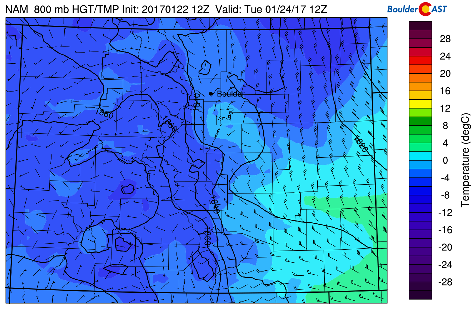
NAM 800 mb temperature map for Tuesday at 5AM. The cold front is already through the Denver Metro area.
There is even some light upslope (northeast winds) around Boulder which could fuel light snow showers in and near the Foothills during the day Tuesday, particularly in areas closer the Wyoming border. Accumulations from this would be light, generally less than 1/2″ near Boulder…with maybe an inch or two towards the Wyoming border. Tuesday’s high will probably be at midnight, with temperatures falling through the 30’s into the 20’s throughout the day as cooler air filters in from the north.
Quieting down by Wednesday
The energy associated with the trough eventually consolidates towards the Great Lakes by Wednesday, with the trough itself elongating into the Desert Southwest. Here is the trough on Wednesday…
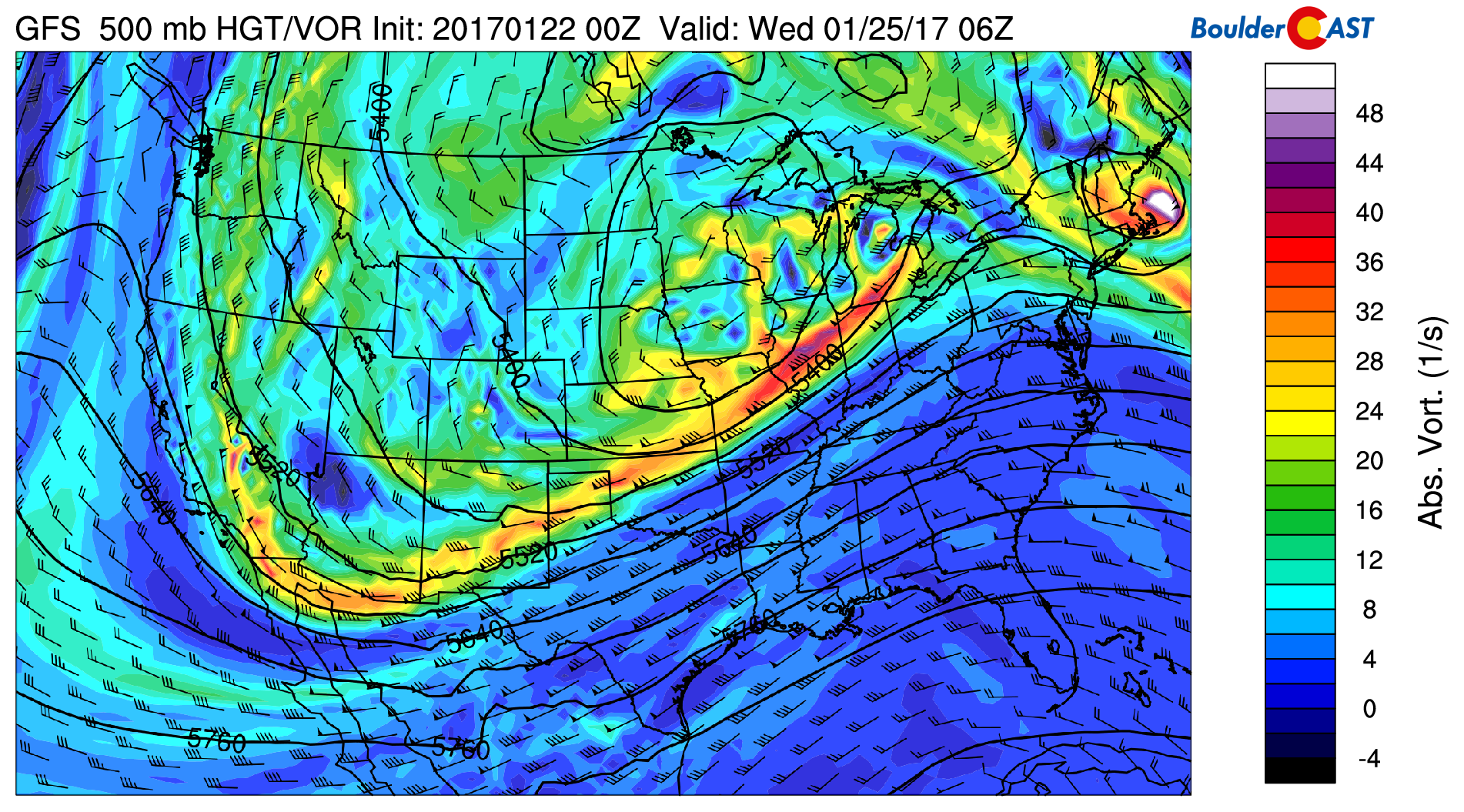
GFS 500 mb vorticity map for Tuesday night
By Friday, the trough elongates to the point that it literally stretches from coast to coast. Elongated troughs with extremely positively tilted axes are usually weak and don’t spark much exciting weather. This one will be no exception.
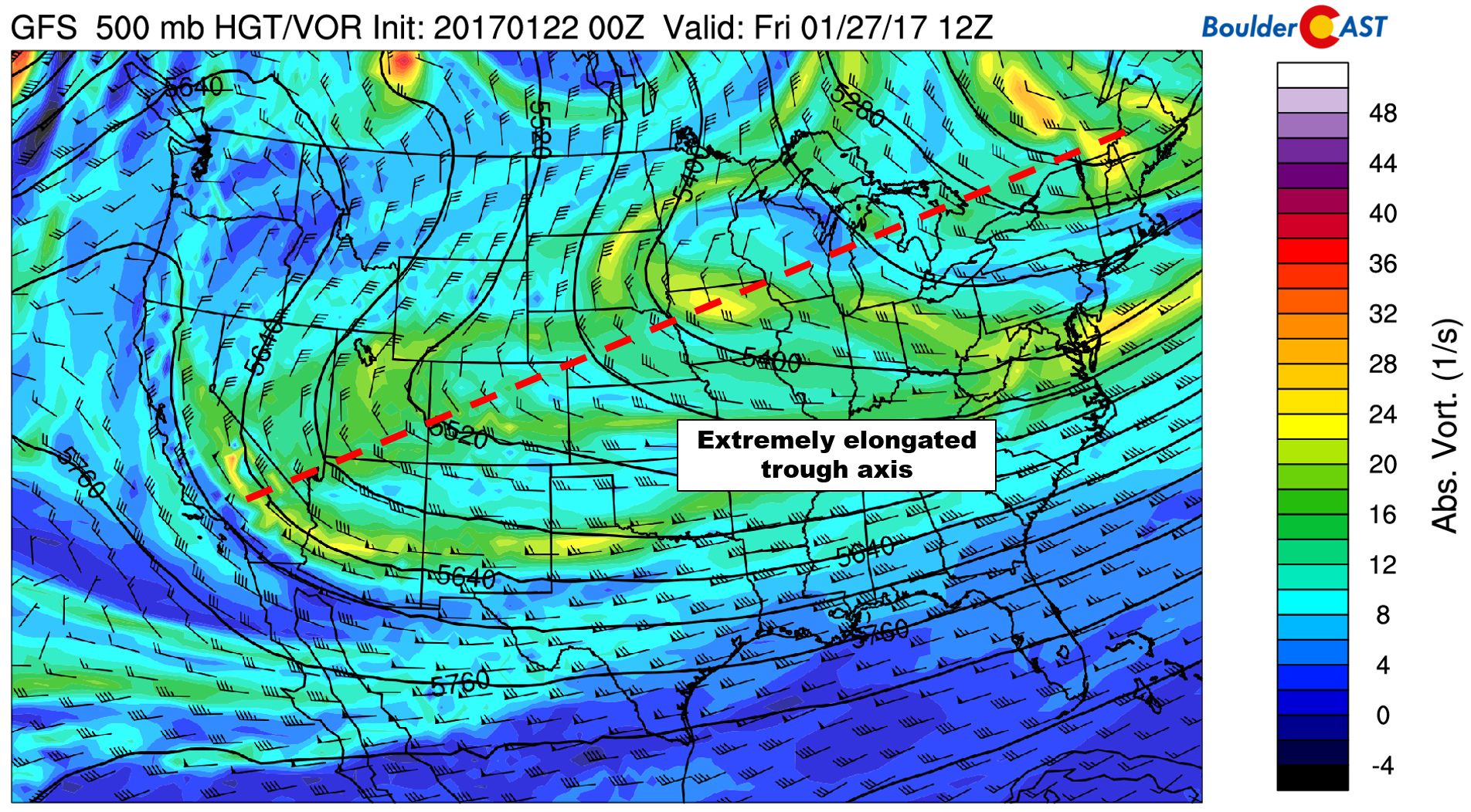
GFS 500 mb vorticity map for Friday morning showing a near east-west trough axis spanning the country, bisecting Colorado
Notice the weak northerly flow in place for Colorado at 500 mb (both maps above). With this air originating over central Canada (super dry) and little to no forcing, our weather turns tame to end the week.
We’ll see some clouds Wednesday morning as the trough energy moves east, but sunshine should break through in the afternoon. Thursday and Friday will have plentiful sunshine. Temperatures won’t be warming up much, though. The northerly flow will keep us in the 30’s through Friday on the Plains, and in the 20’s in the Foothills.
Looking out a bit further, model ensembles are in fairly good agreement that a high-amplitude ridge will build in across the Pacific Northwest through the weekend (see below). This will shut off the Pacific storm track for the time being and bring warmer and quieter conditions to Colorado heading into next week! This is the type of pattern that spawns warm conditions in the northwest, and brings cold air outbreaks to the northeast United States. For Colorado, things are a little less clear-cut and could go either way. We’ll need to watch this set-up for next week!
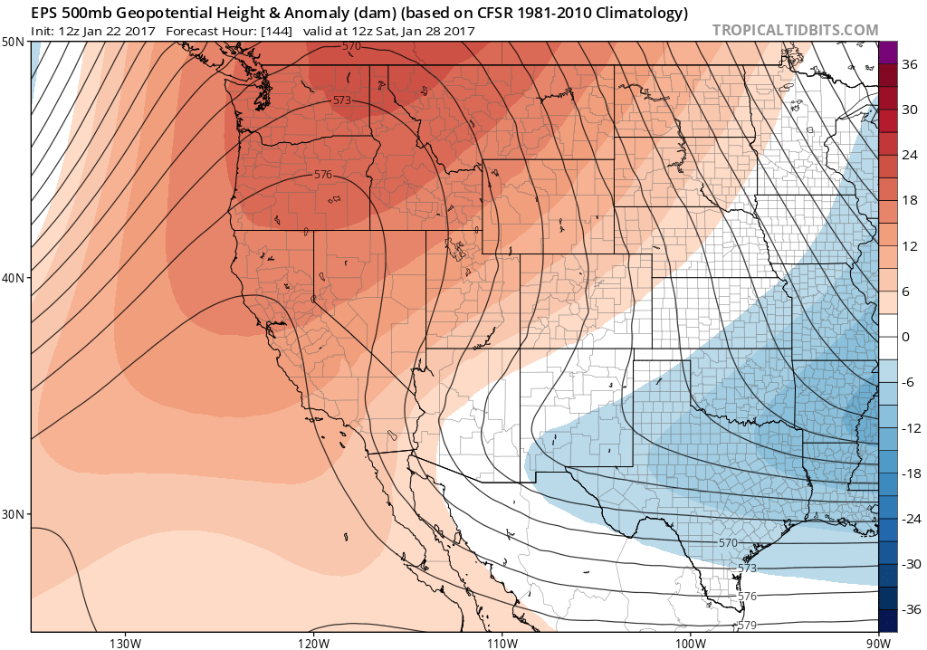
ECMWF ensemble 500 mb height forecast and anomaly for Saturday, showing a high amplitude ridge across Washington and Oregon
Forecast Specifics:
Monday: Partly sunny and mild with highs in the low 50’s on the Plains and upper 30’s in the Foothills. It is possible a few rain showers could spill into the Metro area during the late afternoon and evening, but these would be very isolated and remain in the form of rain. The higher Foothills west of Peak-to-Peak could see 1-2″ of accumulation through Monday night.
Tuesday: Overcast and colder with a morning high in the mid 30’s, falling into the 20’s by late afternoon. Patchy snow showers and freezing fog will be possible in the Foothills and Plains with upslope flow in place. Light accumulations, generally less than 1/2″, may be possible.
Wednesday: Cloudy early with some sunshine in the afternoon. Highs in the low 30’s across the Plains and near 20 in the Foothills.
Thursday: Sunny but still chilly. Highs will be in the mid 30’s on the Plains with mid 20’s in the Foothills.
Friday: Plenty of sunshine with highs on the Plains in the mid to upper 30’s. The Foothills should warm into the mid to upper 20’s.
High Country: Snow will be moderate and widespread in the Mountains Monday into Monday night with 5 to 12″ in many spots. Areas favored by southwest flow (such as the San Juans) could see 16″ or more. Snow decreases in intensity Tuesday morning, but may linger with a few inches of additional accumulation. Wednesday through Friday will generally be dry across the High Country, though we can’t rule out isolated snow showers in areas favored by northwest flow (i.e. Steamboat).
Mon
Tue
Wed
Thu
Fri


Temperature
52
38
33
35
38


Precip Chc (Plains)
20%
20%
0%
0%
0%


.


You must be logged in to post a comment.