
Overall mild temperatures will be present this week across the Plains under a mixture of clouds and sunshine. The Mountains will see more snow starting Tuesday night and continuing off and on through Friday. We also detail a return to cold and a chance of snow come Friday.
Wet snow totals from last Friday
Dense snow from last Friday’s snow event still covers the ground across most of the Metro area. The storm played out much as expected, with marginal temperatures leading to a low snow ratios and lots of melting across the lower elevations.
In Boulder, precipitation began as rain a few hours before sunrise on Friday, but quickly changed to snow with temperatures cooling to 33 degrees Friday morning. Snow continued throughout the day, mixing with a little bit of rain during the afternoon, before changing back to all snow during the evening hours. As we discussed in our forecast, there wasn’t much cooling available with this system and temperatures never dropped below 33 degrees as snow was falling. Also notice in the graphic below that low-level winds in Boulder were NNW all day long (weak downslope).

Shown below is our snowfall forecast map with totals overlaid in boxes. Green boxes indicate that our forecast verified to within one inch of the observed snowfall. Red did not.
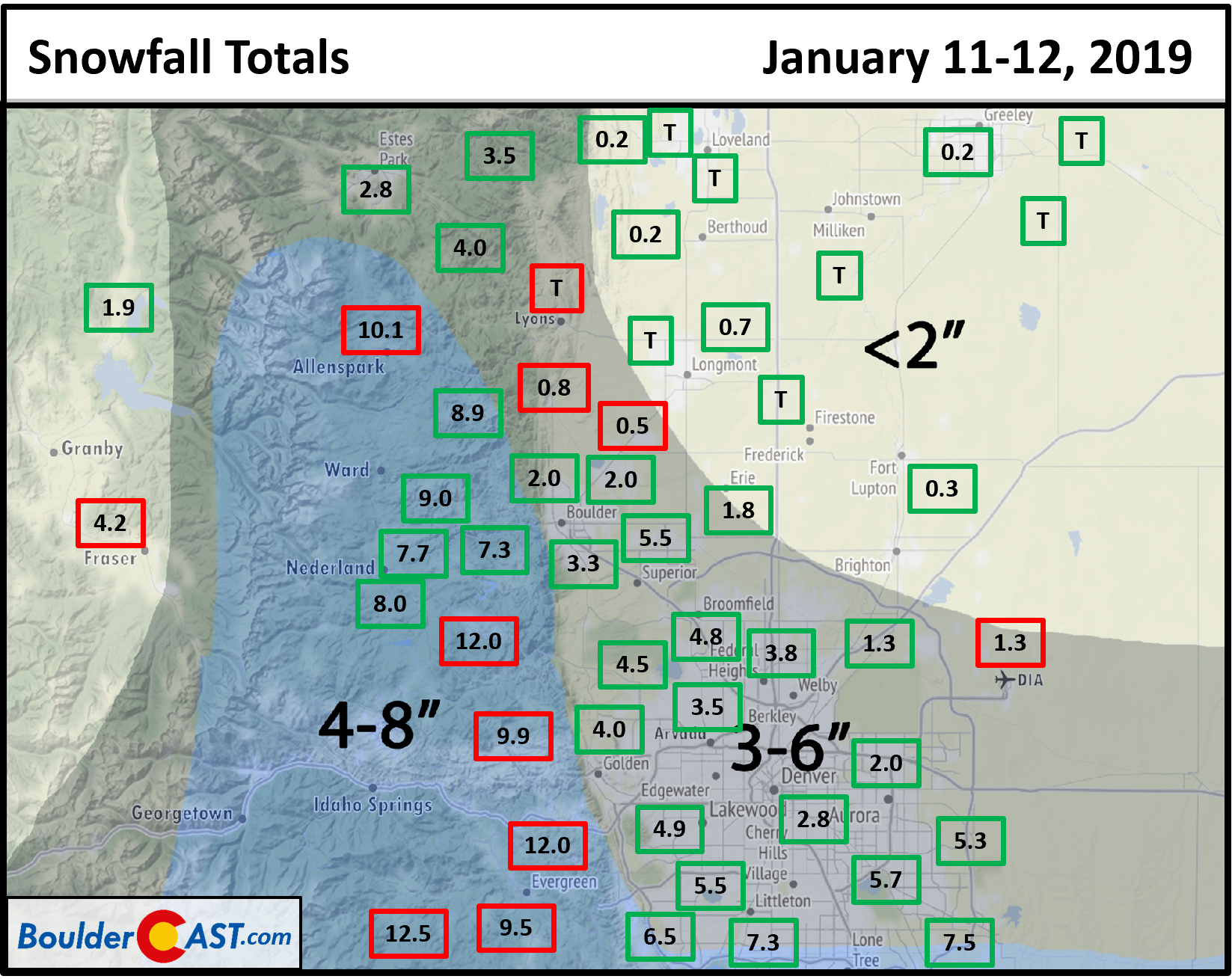
Overall most locations landed within the bounds of our snowfall forecast. However, there were two exceptions:
- The Foothills southwest of Denver saw more than 1″ of liquid in some cases. This was on the high extreme end of the forecast potential. Snow totals from Allenspark south to Evergreen ended up in the 8 to 13″ range.
- The boundary between our 3-6″ forecast and 0-2″ forecast should have been about 5 or 10 miles further south. Places such as Lyons, Niwot and DIA reported 1″ or less of snow.
Boulder’s official total was 3.3″ from this storm, contained in 0.75″ of liquid (a snow ratio of 4:1). Denver International Airport reported just 1.3″ of new snow.
Tranquil Monday
We begin the week with Colorado sandwiched between two troughs. One is present in Minnesota, while a second is present off the coast of California. This is evident below in the upper-level jet stream pattern across the CONUS. The jet stream remains to our south, that is, the subtropical jet. The polar jet carrying the cold air is up in Canada. Hence, a warm-up is in-store this week.

GFS 250 mb wind speed and height today
We should see generally sunny skies this afternoon with highs in the lower 50’s.
Quiet on Plains…Snow develops in High Country Tuesday
On Tuesday (below), the trough off California moves north-northeast. As it does so, it spreads general southwest flow over the inter-mountain West. A weak shortwave system will be embedded in this larger trough pattern, with a trough axis situated over western Colorado Tuesday night. While the system in Utah is not very impressive, enough upslope across the Western Slope and Divide will lead to snow showers developing Tuesday night in the Mountains. This snow should continue into early Wednesday, tapering off Wednesday afternoon.

NAM 500 mb absolute vorticity on Tuesday
As for the Plains, we remain tranquil once again; however, high clouds from time to time will spread in from the southwest flow and likely lead to some milky skies with highs again in the lower 50’s.
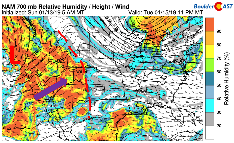
NAM 700 mb relative humidity on Tuesday
Mild conditions through Thursday
Although we already mentioned it above, the mild temperatures for the Plains will persist at least into Thursday, after which a cold front approaches to end our work week on Friday. Below shows the low-level temperature fields for today and Wednesday. As you’ll notice for eastern Colorado, not much changes over the Plains, with temperatures at or near 4 degC at 800 mb. The flow is also weak and not conducive to downslope winds, which should keep highs very similar each day. Thursday, however, downslope flow ensues and thus some warmer air is possible in the middle 50’s.

NAM 800 mb temperature on Monday (left) and Wednesday (right)
Colder to end week with chance of snow
On Friday, the polar jet reemerges from its hiatus and dives southward into Colorado and Utah (below). The current projected position of the jet will lead to another round of snow Thursday into Saturday for the Mountains, as well as gusty northwest winds and colder air filtering in on the Plains Friday.
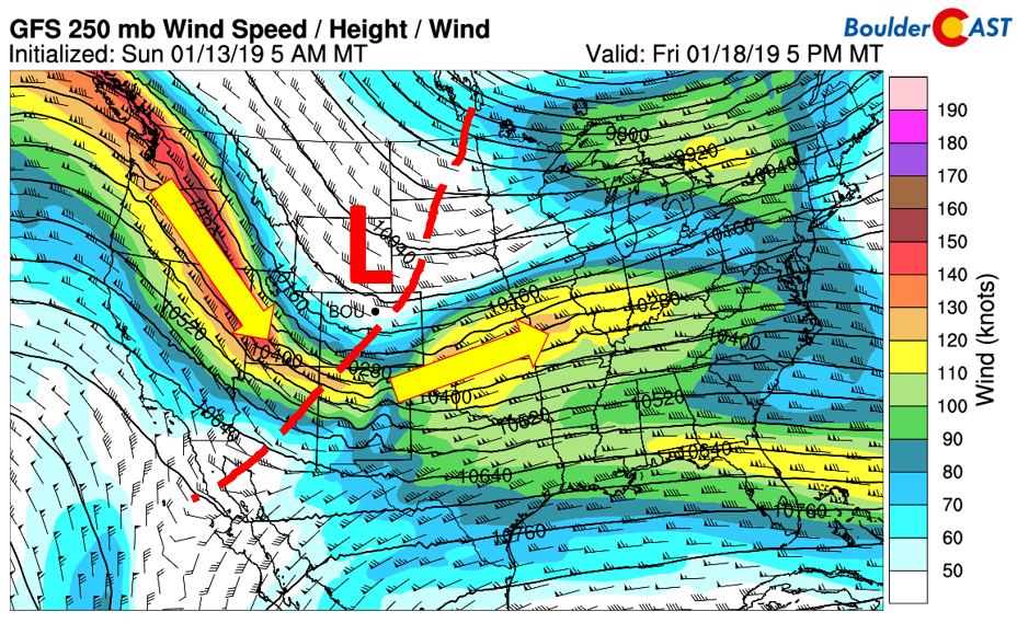
GFS 250 mb jet stream on Friday
Below shows that accompanying the jet will be much colder air out of Canada. The cold will entrench much of the state, and also the upper and central Midwest (below). Currently, the pattern indicates a more west-northwest flow in the mid-levels for the Plains Friday evening. While there is a chance of snow with the frontal passage, this projected pattern isn’t very conducive to snow for the Denver Metro. The Euro model brings a slightly more favorable pattern for precipitation in Denver, but it’s still quite far out. We’ll have to watch it closely, but we think it will be mostly dry for us.

GFS 700 mb temperature Friday night
The Mountains, however, will be basking in new snow this week! A series of systems, the first one Tuesday night/Wednesday, and a second with the jet stream above on Thursday/Friday, will lead to lots of fresh snow for the ski resorts. The GFS shows over a foot of snow for several spots along the western High Country. A good week to dust off the skis and snowboards if you just got back for a new CU semester! The Plains, however, will be relatively dry. The GFS does show an inch or two possible with the Friday system, but our confidence in this is not very high.

GFS total snow through Friday
Forecast Specifics:
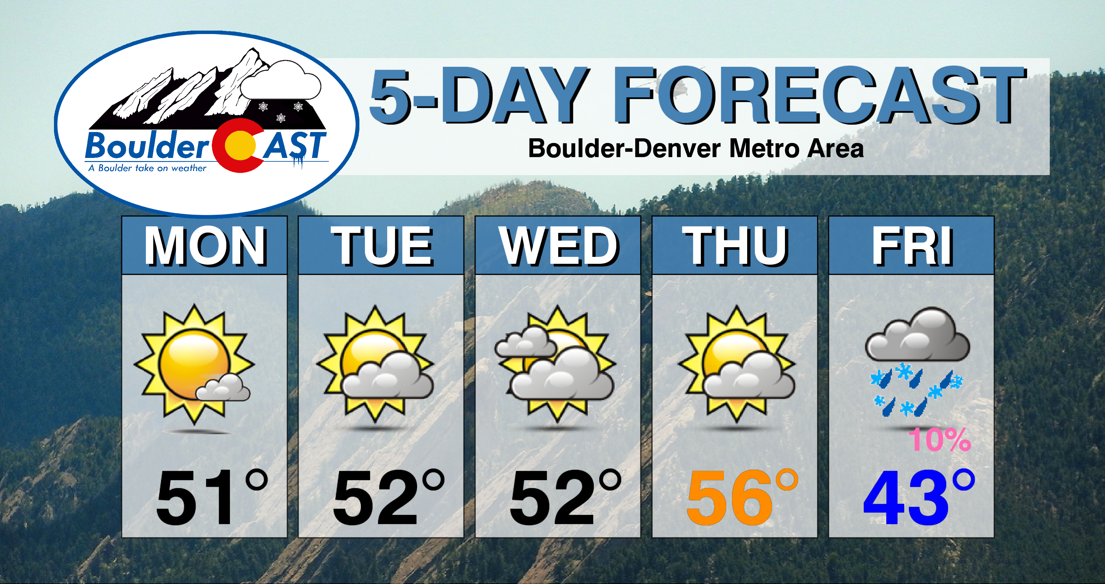
Monday: Mostly sunny skies with a few passing cirrus clouds. Highs in the lower 50’s on the Plains with upper 30’s in the Foothills.
Tuesday: A mixture of clouds and sunshine with highs in the lower 50’s across the Plains and in the lower 40’s in the Foothills.
Wednesday: More cloud cover, but still mild. Highs in the low to middle 50’s on the Plains and lower 40’s in the Foothills.
Thursday: Winds out of the west under partly cloudy skies. Highs in the middle 50’s on the Plains and in the middle 40’s in the Foothills.
Friday: Mostly cloudy with a chance of light rain or snow showers throughout the day and evening. Gusty and colder with highs in the middle 40’s falling into the 20’s for the Plains and Foothills by late evening.
High Country: Tranquil weather starts off the week for the mountains. Another round of snow starts tomorrow night and tapers on Wednesday afternoon. Amounts in the 2-5″ range are possible. Another storm moves in Thursday into Saturday, with amounts likely higher and possibly 6+” of snow for many ski resorts. Check PowderCAST for updated forecasts for all the Colorado ski resorts.
DISCLAIMER: This weekly outlook forecast was created Monday morning and covers the entire upcoming week. Accuracy will decrease as the week progresses as this post is NOT updated. To receive daily updated forecasts, subscribe to BoulderCAST Premium.

.
Share our forecast!


You must be logged in to post a comment.