After a warm and pleasant weekend, the trend this week is toward colder weather after a few more warm days. Arctic air will make its way back in by the middle of the week, along with the chance of snow both across the Plains and in the Mountains. Read on to find out more.
W
e hope you were able to get outside over the weekend…what exceptional weather we had. Highs Saturday and Sunday were in the lower 60’s with lots of sunshine…it got me excited for hiking and biking season which is just around the corner! We hope you enjoyed watching the Super Bowl as well with friends and family. The BoulderCAST team spent the evening together watching it – good times. Congrats to the Patriots and Tom Brady….what a career. As much as most of us despise the Patriots, we must give credit where it is due.
Mild to start…a look ahead to the week
We start out our week with a continuation of above average temperatures. Below shows the 700 mb wind, height, and relative humidity on this Monday. A strong trough is situated off the coast of Oregon. Persistent and deep southwest flow remains across much of the western U.S. In the vicinity of the trough, high relative humidity values are present, at or above 90% for much of the western states. The continued southwest winds in western Colorado will lead to another round of snow for the ski resorts and mountains tonight. In fact, this will be the story through the coming days, with feet of snow possible by the end of the week! For the Plains, we should see a mixture of clouds and sunshine on Monday. Highs will be similar to the weekend in the upper 50’s to near 60 degrees.

GFS 700 mb relative humidity today
A look ahead to the week is shown below from the GEFS ensemble temperature outlook. Note how the first few days of the week will be above average. We’ll talk more about Tuesday in a minute as there is some uncertainty there, but Wednesday onward will likely be below to well below average. The Arctic air plunges down early Wednesday along with the chance of snow.
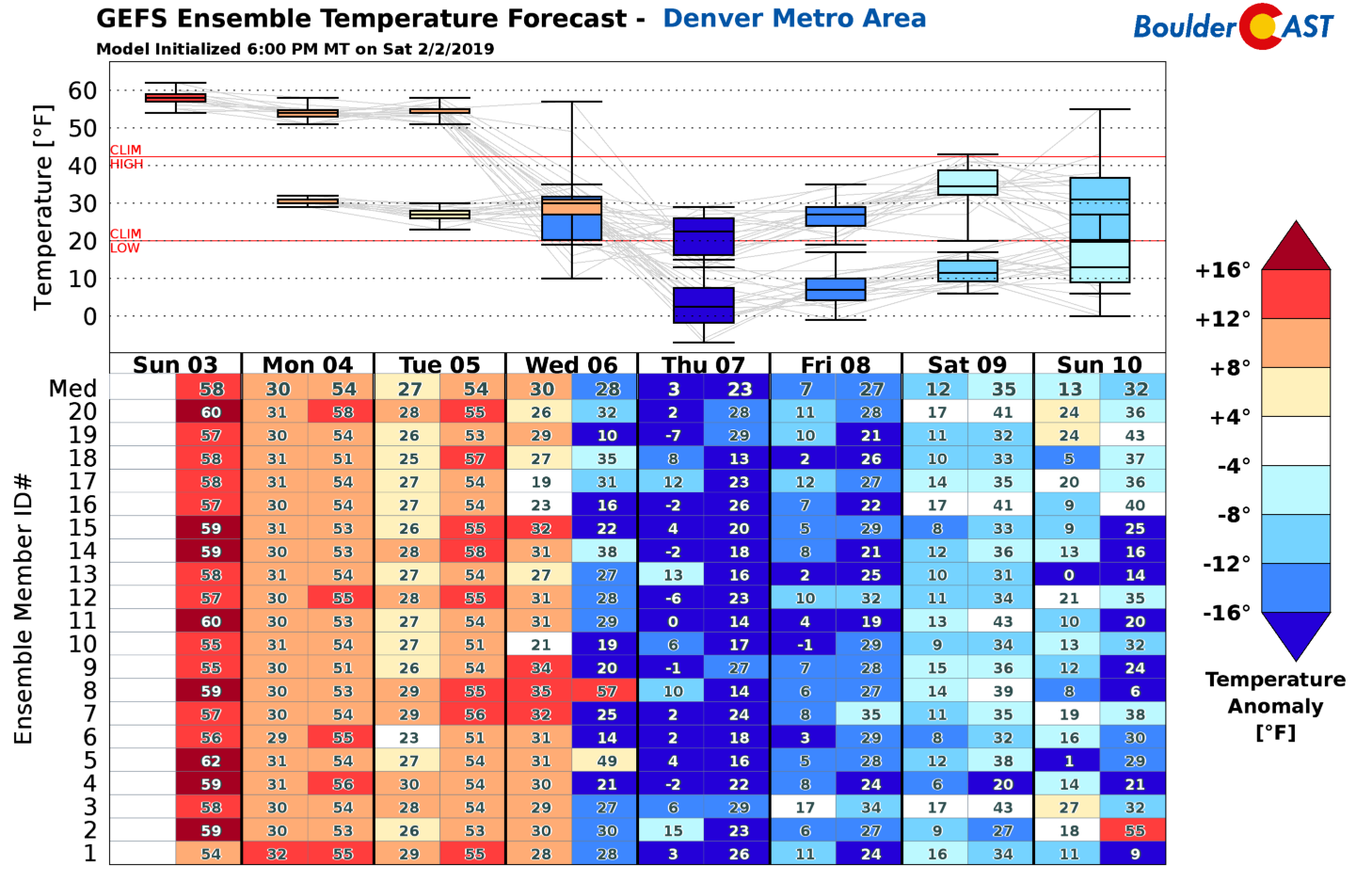
GEFS ensemble temperature forecast for the week
Tuesday a transition day
On Tuesday, the weather will be in a state of transition. The trough out West will inch closer but still remain across Nevada. However, the Arctic air will slowly start to edge southward as heights dip across Montana, Wyoming, and northern Colorado. There are some notable differences in the models for Tuesday. First off, all models keep the coldest air north of our region. Differences lie in the ability for a small portion of this cold pool to penetrate northeast Colorado. The GFS keeps this “cold pool” in Wyoming and Nebraska (bottom left), while the NAM brings it near the Front Range. This leads to a big discrepancy in our highs for Tuesday, anywhere from middle 40’s to middle 50’s. Right now we are taking the middle ground with highs cooler in the mid to upper 40’s, but could be chillier if the cold intrusion is realized.
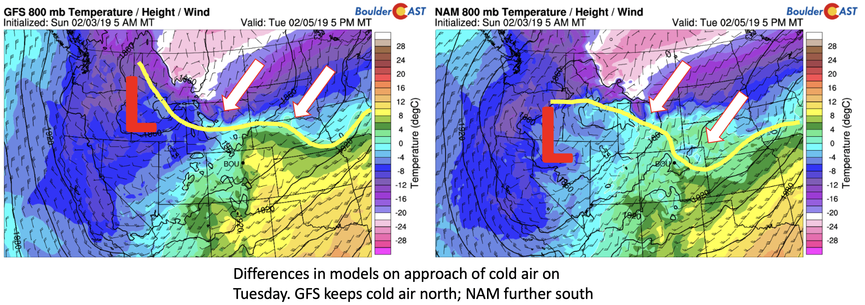
GFS and NAM 800 mb temperature outlook on Tuesday
Arctic air returns Wednesday and Thursday…snow?
On Wednesday, the Arctic air surges in from the north. All models indicate this with northeast winds taking over. Highs early Wednesday will likely start out in the 30’s, dipping through the day into the 20’s, and eventually into the single digits Wednesday night. Along with the cold front, there will be the threat of snowfall with the trough out West finally traversing eastward. Our current thinking can be summarized below, showing the GFS and NAM mid-level pattern during Wednesday evening. Both models have the low pressure center between western and northwestern Colorado. Its track is a little north of where we’d like it for good snow amounts, but upslope will be decent with the cold front. The NAM and GFS also show a secondary shortwave diving down from Idaho that may lead to a secondary push of lift Wednesday night into Thursday morning. There will thus be two chances of snow Wednesday.
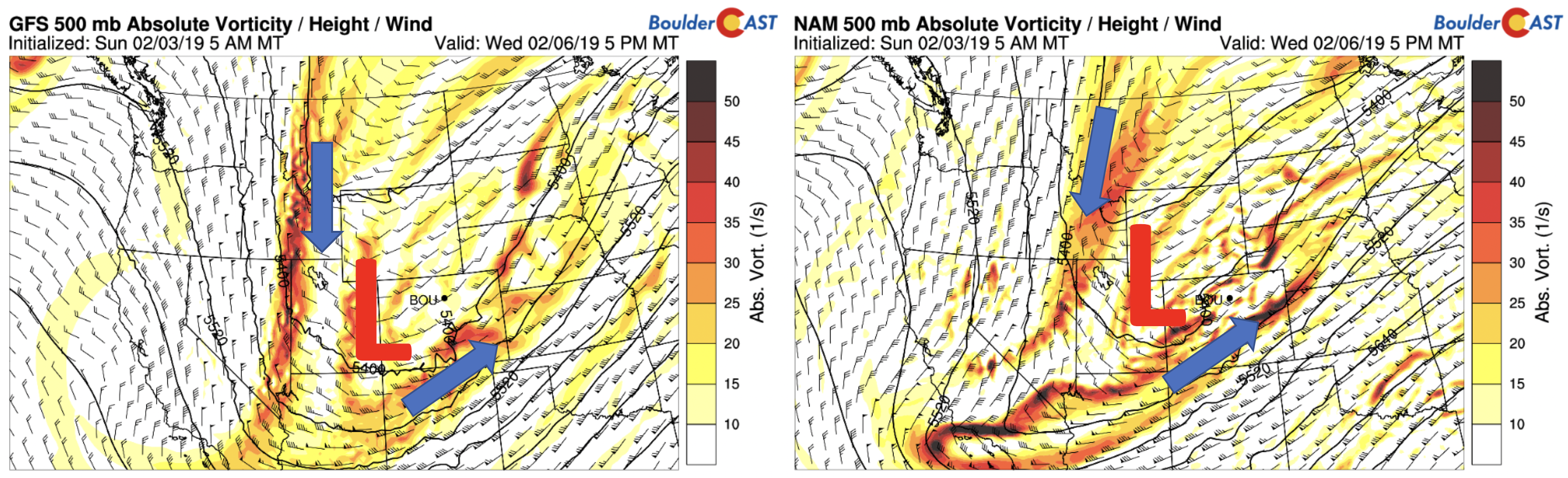
GFS and NAM 500 mb absolute vorticity on Wednesday
There is good agreement in the global and regional models, and ensembles. Every member of the GEFS ensemble (below) has snow in Boulder on Wednesday, mostly in the evening timeframe as is currently stands. The mean precipitation is around 0.3 to 0.4 inches, good enough for 3-5″ potential.
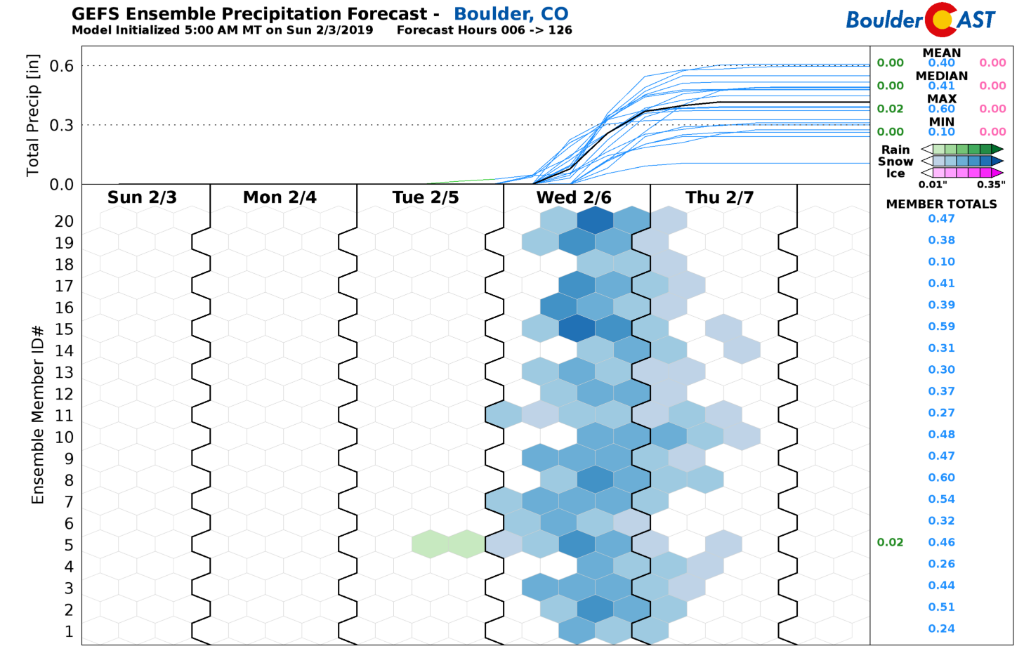
GEFS snow predictions for the week
The GFS and NAM (below) both also show a good swath of 2-5″ across the Plains, though, as expected, there are differences on placement. Our current thinking is this: Cold air is plentiful, so it will be all snow and no rain. Second, the system is deep but its track is not the most favorable for high amounts – this could change though. Third, upslope is somewhat weak to moderate depending on storm track. Arctic air will lead to high snow to liquid ratios, so only a small amount of precipitation is needed for good snow amounts. We put a good chance of up to 4″ for some portions of the Denver Metro area, supported by the ensembles. We’ll update you as we get closer. The High Country will see several inches of snow from Monday through Thursday. In fact, some areas could see over 2 feet of powder! Avalanche warnings are likely this week.
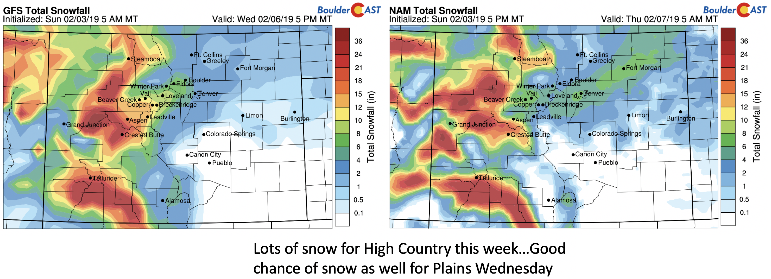
GFS and NAM snowfall forecast through Thursday
Arctic air will be the story Wednesday night and Thursday. Our lows Thursday morning will dip likely into the single digits and top out in the 20’s Thursday. The temperatures near 10,000 feet up are as cold as -20 degC, evident below.
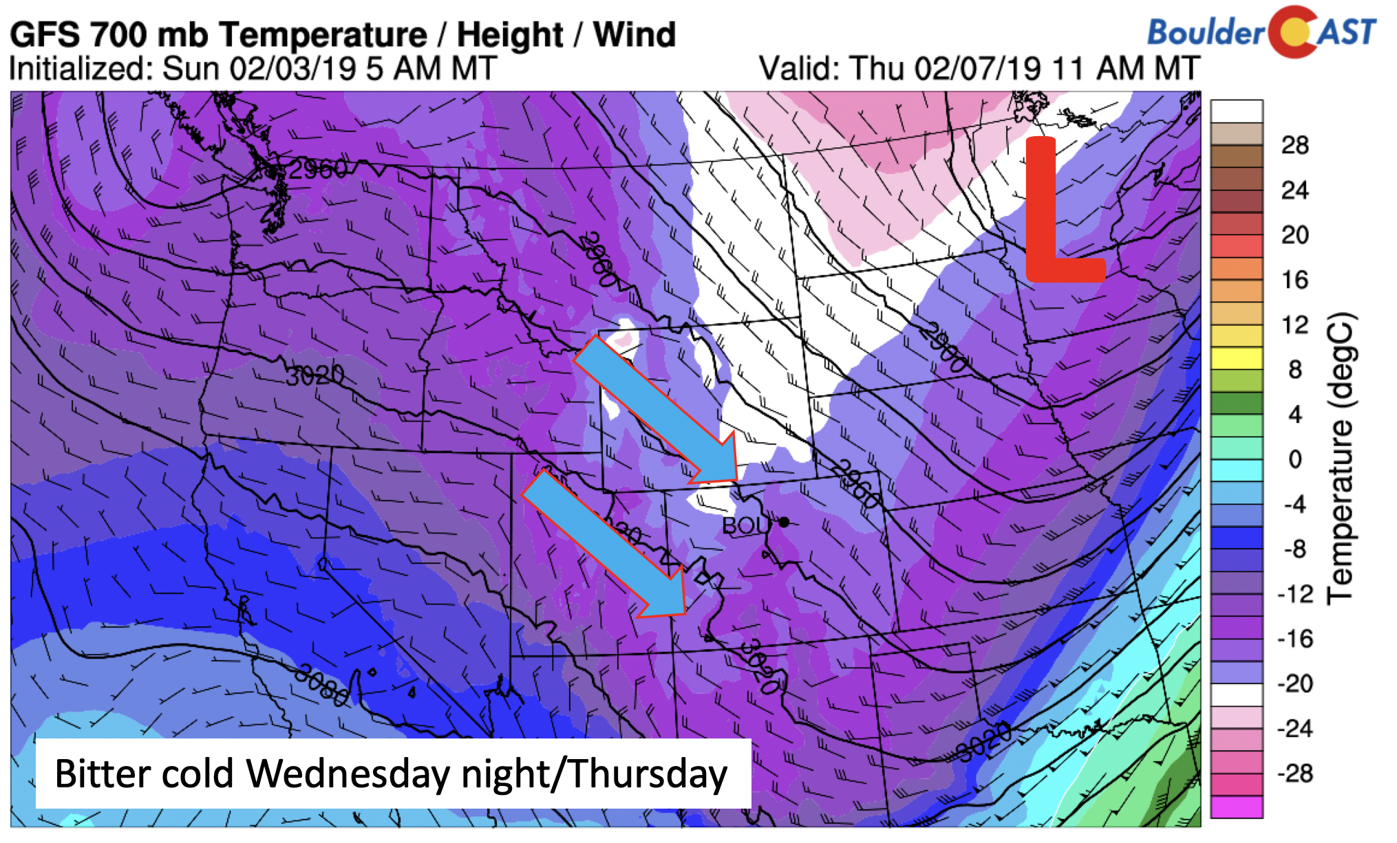
GFS 700 mb temperature Thursday
Warmth to end week
We end the week with warmth slowly returning. The pattern on Friday is shown below. Ridging is expected to take over, with southwest winds pushing the Arctic air back north. Depending on how quickly the cold airmass gets ousted, high temperatures Friday could range from the upper 20’s to lower 40’s. We’re leaning more towards the warm end with our forecast…lower 40’s. However, another trough is lurking in its wake over Oregon. This will lead to the cold air potential to return over the weekend to early next week.
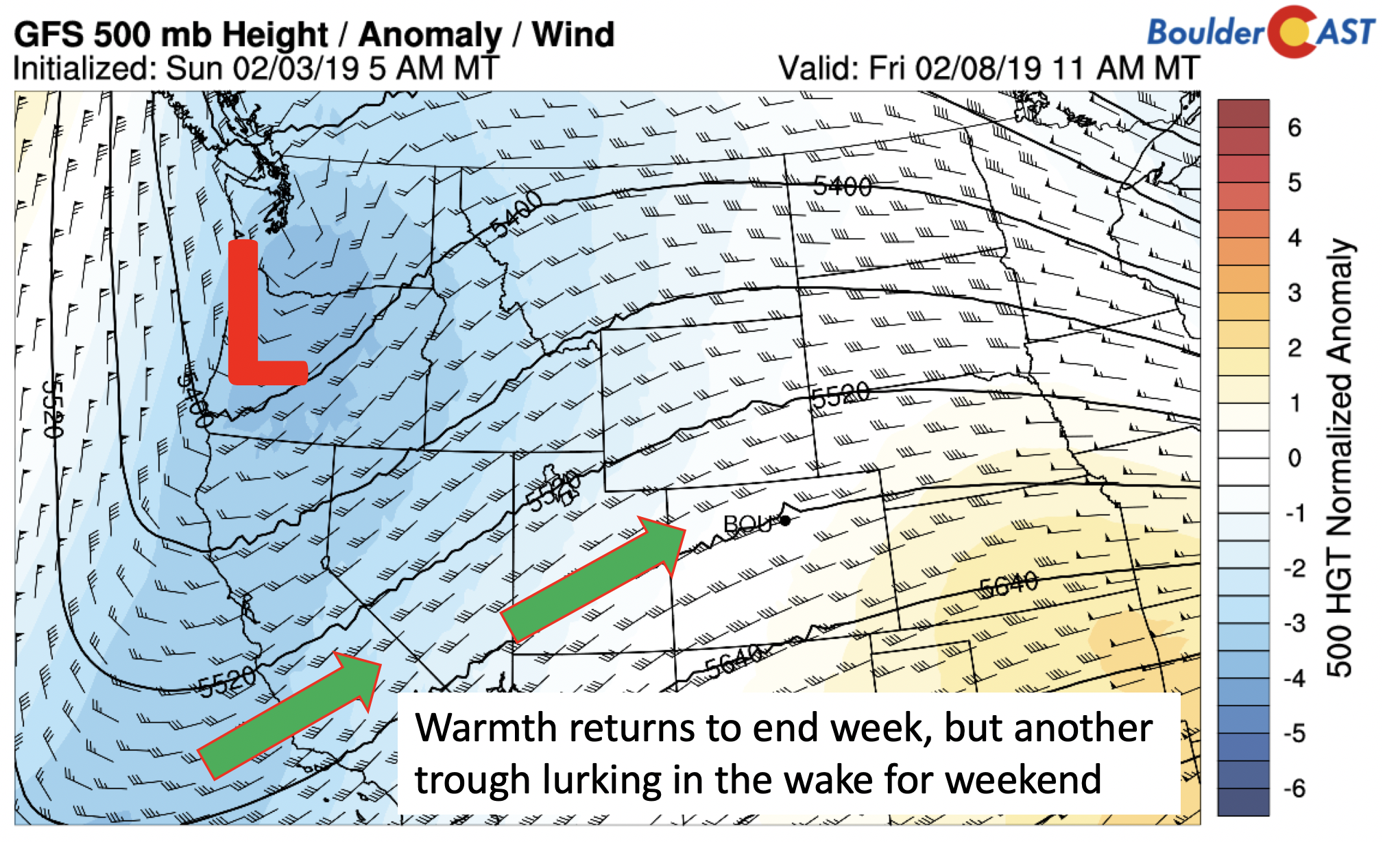
GFS 500 mb height anomaly on Friday
Lastly, we wanted to share a nice fundraiser taking place in a few weeks. Please consider attending and/or sharing this with your friends. The BoulderCAST team will be in attendance (and hosting actually)!

Forecast Specifics:
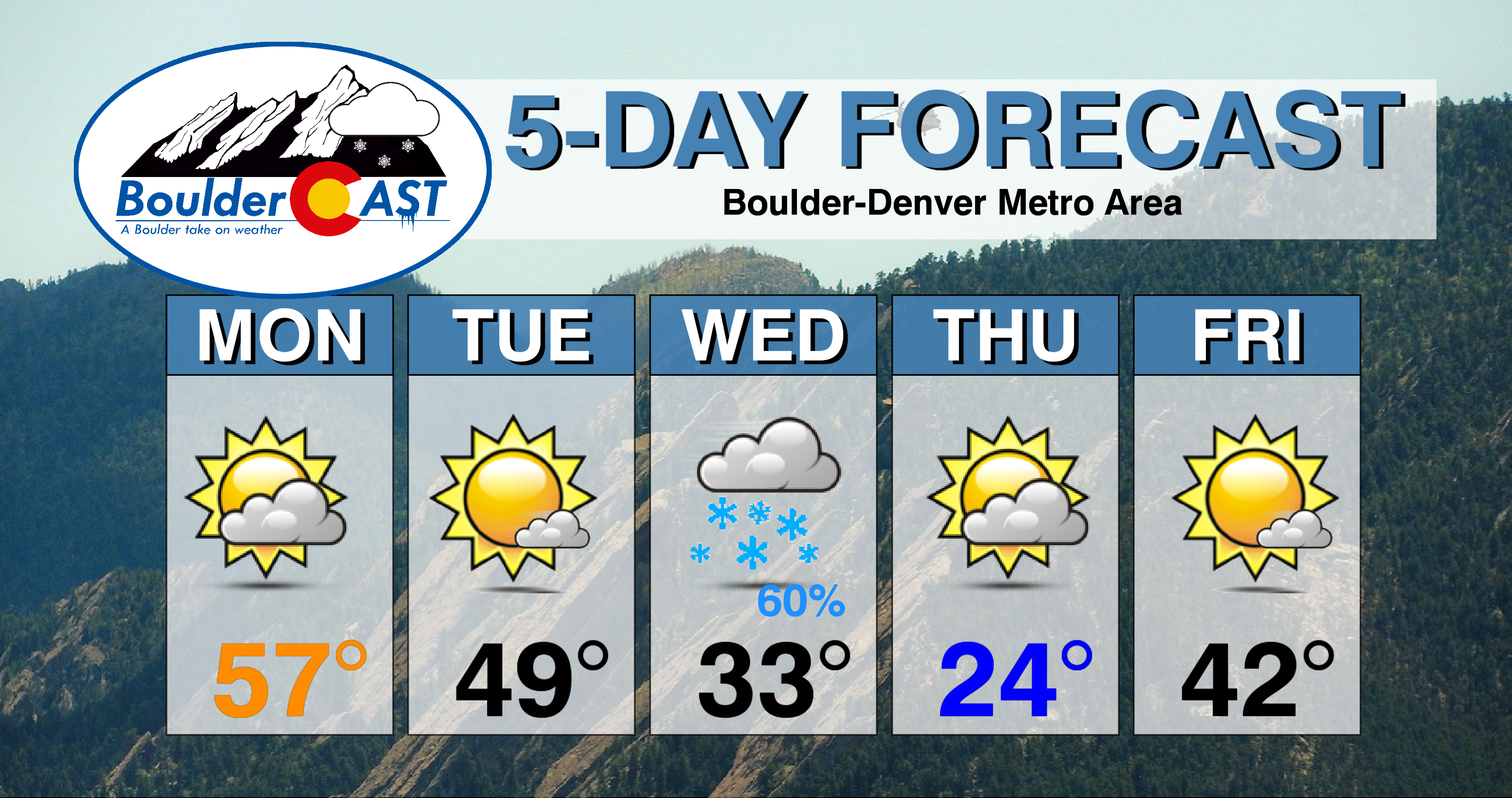
Monday: A mixture of clouds and sunshine with highs in the upper 50’s to lower 60’s on the Plains and in the upper 40’s to low 50’s in the Foothills.
Tuesday: Partly to mostly sunny skies with highs in the middle to upper 40’s on the Plains and in the lower 40’s in the Foothills.
Wednesday: Mostly cloudy and much colder with a good chance of snow in the afternoon and evening. Highs in the lower 30’s on the Plains, dipping to the teens later in the day. In the Foothills, highs in the 20’s, dipping into the single digits. A few inches of snow are possible.
Thursday: Cold with decreasing clouds and highs in the middle 20’s on the Plains and upper teens in the Foothills.
Friday: Mostly sunny and warmer with highs in the upper 30’s to near 40 on the Plains and lower 30’s in the Foothills.
High Country: Snowfall will be likely for the mountains almost every day, except Friday. A wave of snow returns tonight, and continues off and on Tuesday through Thursday. Several inches of snow are likely, with some ski resorts and mountains seeing 2 feet or more by Friday. Avalanche warnings are likely so if you are doing backcountry skiing, be safe. Check PowderCAST for updated forecasts for all the Colorado ski resorts.
DISCLAIMER: This weekly outlook forecast was created Tuesday morning and covers the entire upcoming week. Accuracy will decrease as the week progresses as this post is NOT updated. To receive daily updated forecasts from our team, subscribe to BoulderCAST Premium.

.
Share our forecast!


You must be logged in to post a comment.