
Despite a generally troughy pattern remaining across the western United States this week, things in Colorado will be relatively quiet. Snow chances will be next to zero for the lower elevations, with only one brief period of light snow expected in the Mountains. Temperatures will also be much warmer this week compared to last.
Friday evening snow recap
You may be thinking to yourself…. “When did it snow Friday evening?”. An overhead jet streak led to a few isolated heavy snow bands exclusively across the northwestern fringe of the Metro area. If you weren’t in Boulder or Larimer Counties, it actually didn’t snow in your location on Friday! The radar animation below is from 3:00 to 9:00 PM across the Metro area. Notice the formation of the bands and the lack of almost any movement for hours. As a result, while many areas saw no snow, the ones that did picked up several inches.

Radar animation showing the small-scale nature of the banded snow on Friday. Only Boulder and Larimer Counties were impacted. This loop covers 3:00PM to 9:00PM on Friday February 23, 2018.
Shown below is our original snowfall forecast map issued Friday morning. The observed snow totals from the event are contained in boxes. Green ones indicate the observed total was within our forecast range, while red was not.
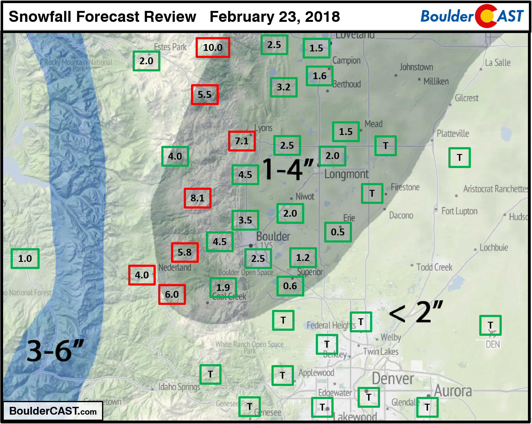
We did a good job of identifying the location of the banding itself, a difficult aspect in its own right. The band was only about 10 miles wide! Snow amounts within the core of the stationary band did exceed our forecast range, however. Totals in the Foothills northwest of Boulder were some 5 to 8 inches. The official total in the city itself was 2.5″.
You can find a recap of all 12 winter storms so far this year along with our seasonal snowfall totals HERE.
Quiet week ahead
Looking at the 500 mb height anomaly animation for the week ahead, there is good bit going on! However, the net impact on the Front Range will be limited.
- A trough comes ashore on Monday in California and dives southward into Arizona. This feature will bring a chance of snow to mainly southwestern Colorado on Wednesday.
- Another larger and more potent system comes into the Pacific Northwest Thursday evening. It’s unclear if and when this trough will impact Colorado.
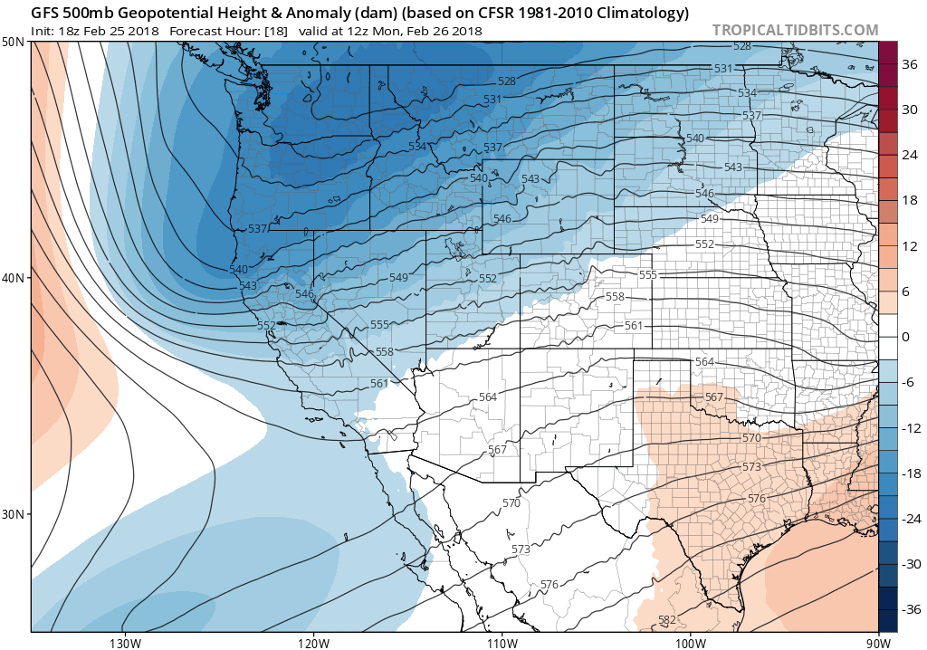
GFS 500 mb height anomaly animation for the week ahead. Two troughs come ashore, but neither looks promising to impact Colorado directly.
Here’s what that first system looks like at 500 mb on Monday, along with its projected track over the next few days through Arizona and New Mexico.

GFS 500 mb map for Monday showing a trough in California and southwest flow across Colorado.
Until the system arrives, dry southwest flow will lead to warming temperatures across northeast Colorado. Highs Monday and Tuesday will be near 50 degrees with sunny skies.
By Wednesday, the low pressure will be near the southern Arizona/New Mexico border (see below). A trough axis extends all the way northward through Colorado. This will help usher in a cold front to the Metro area, bringing more cloud cover and slightly cooler temperatures for us. Highs Wednesday will likely be five to ten degrees cooler. Some models (mainly the NAM) indicate the potential for isolated rain/snow showers across eastern Colorado Wednesday afternoon and evening. These are mostly tied to a developing jet streak aloft. We believe the downsloping across the Front Range should be enough to keep us all dry, despite what the NAM is showing.
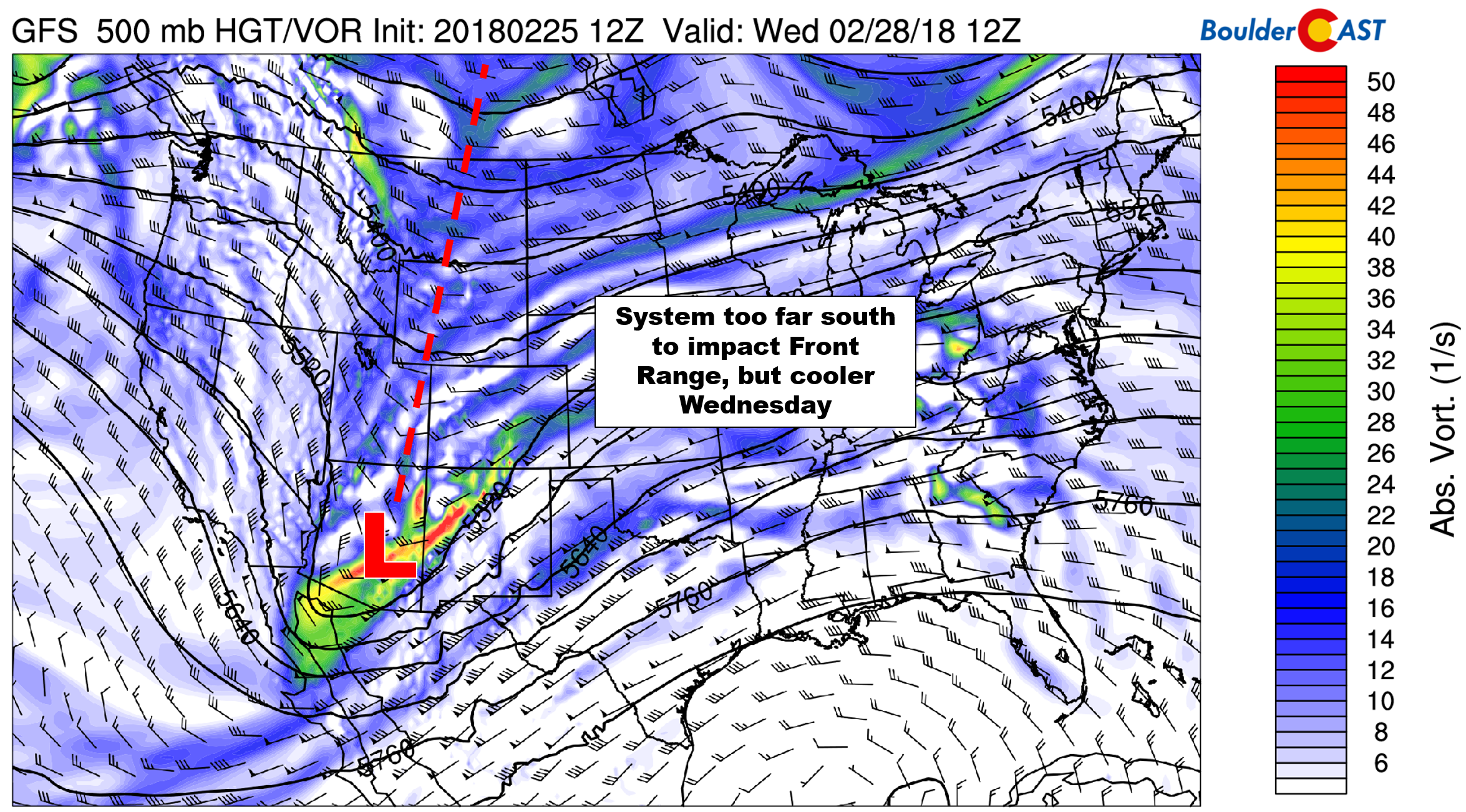
GFS 500 mb vorticity map for Wednesday. A system moves well south of us, bringing mostly just cloud cover to our region.
We’ll end the week on a warm note as southwest flow strengthens across Colorado between a developing ridge in the Midwest and a trough coming ashore in the Pacific Northwest. The GFS and European ensembles generally do not show this trough pushing far enough eastward to impact Colorado over the upcoming weekend. Uncertainty is still high, however. Plan on temperatures ending the week in the 50’s and low 60’s with sunshine prevailing. Right now the weekend also looks mild and breezy, but this could change depending on how this large trough behaves.

ECMWF ensemble forecast for Saturday morning showing the large trough across the PNW.
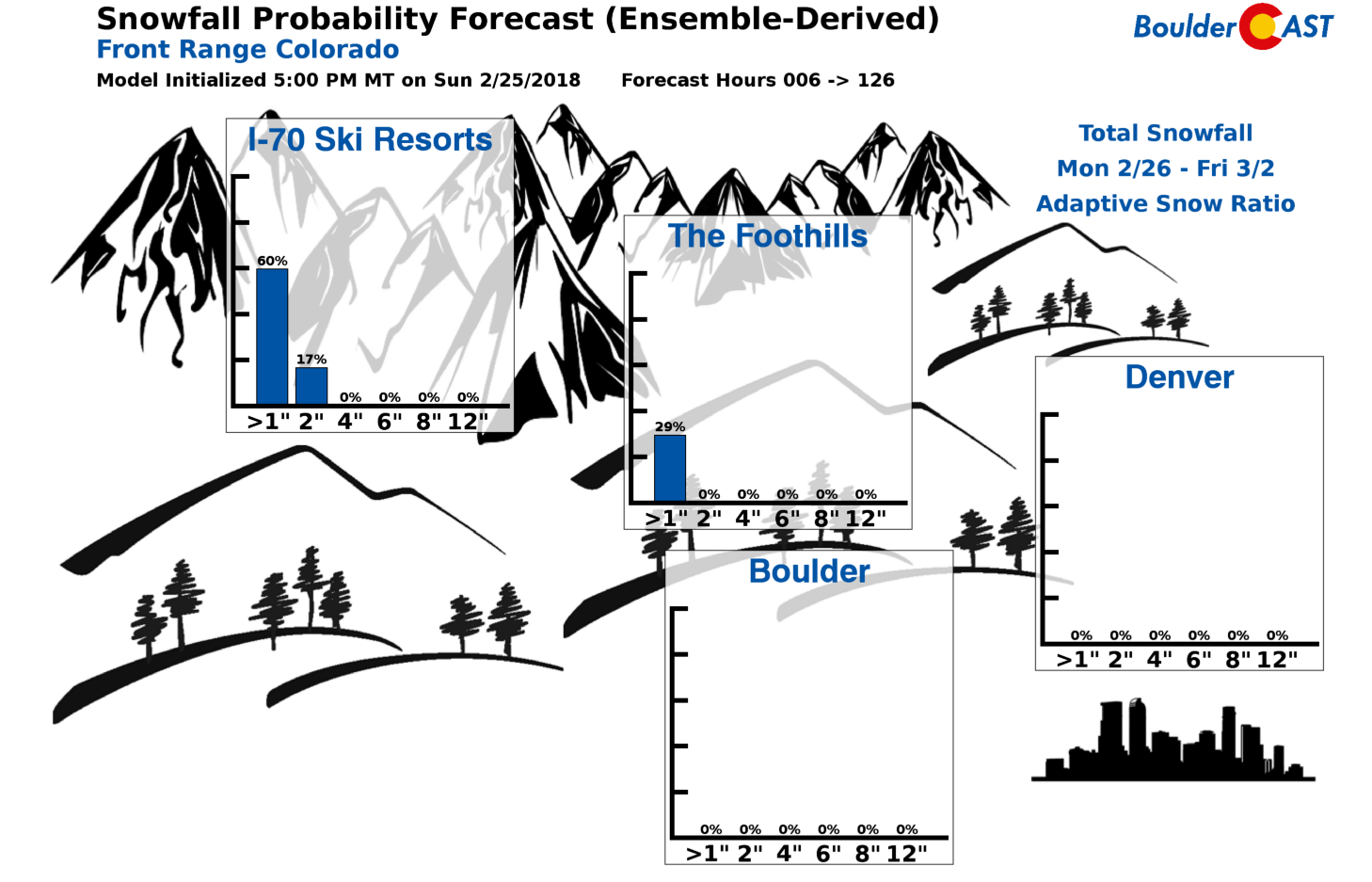
We conclude by talking powder, or lack thereof. The only chance of snow for the skiers this week will be Wednesday, and mainly for just southwest Colorado, and only a few inches at most. Our snowfall probability charts paint a bleak picture for the I-70 resorts this week. While not significant, models are showing light snow returning to the High Country Friday night through the weekend.
Forecast Specifics:
Monday: Sunny and mild with highs in the lower 50’s across the Plains and in the upper 30’s in the Foothills.
Tuesday: Very similar to Monday. Sunny skies and temperatures in the lower 50’s for the Plains with lower 40’s in the Foothills.
Wednesday: Partly to mostly cloudy and cooler. Highs in the middle 40’s across the Plains, and low 30’s in the Foothills.
Thursday: Mostly sunny and dry with temperatures rebounding back into the 50’s for the Plains and into the 40’s in the Foothills.
Friday: Sunshine and quite warm. Temperatures in the low 60’s across the Plains. Expect highs near 50 degrees in the Foothills.
High Country: It will not be a great week for powder…The only chance of snow for the Mountains will come during the day Wednesday. Southwest Colorado will be favored, but even then, we’re only expecting 1-3″. Otherwise, the rest of the week will be dry and mostly sunny. While not significant, models are showing light snow returning to the High Country Friday night through the weekend. Find the latest forecast for all your favorite Colorado ski resorts on our PowderCAST page.

DISCLAIMER: This weekly outlook forecast was created Monday morning and covers the entire upcoming week. Accuracy will decrease as the week progresses as this post is NOT updated. To receive daily updated forecasts, subscribe to BoulderCAST Premium.

.
Share!


You must be logged in to post a comment.