What a wonderfully cool day we had on Sunday. Cooler weather continues early in the week, along with the increase in monsoonal moisture as the week progresses. Warmth and drier conditions take hold later in the week setting the stage for what looks to be a great weekend. We also detail the wildfire smoke situation and provide an outlook on when the smoke may clear out.
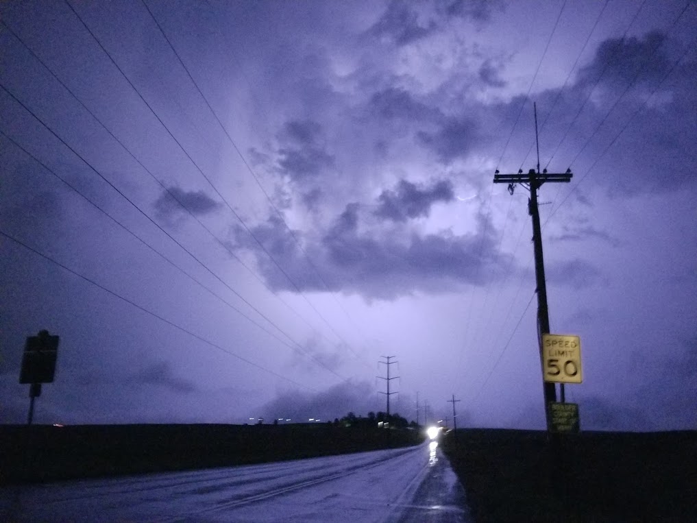
Did you miss Saturday evening’s light show? The picture below doesn’t do it justice, but it was taken on Lookout Road in Gunbarrel looking east towards a cluster of thunderheads around 10:00 PM on Saturday.
Pleasant Monday
We start the week with very pleasant conditions. Our weather situation across the nation is shown below for this afternoon. Saturday’s low pressure system has moved into Missouri, while a secondary one is located near Oregon and Idaho. High pressure exists to our south in New Mexico and Arizona.
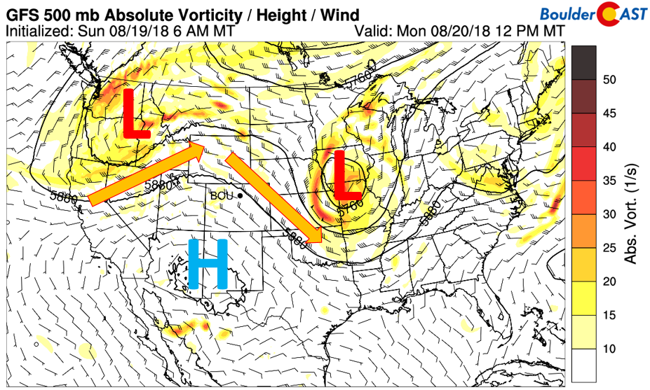
GFS 500 mb absolute vorticity today
Northerly flow remains entrenched across the eastern third of our state. This is evident below with cooler air spreading in from the north and east. The cold front is draped north-south across the Front Range. Thanks to this, today will be a great day to be outside with highs in the upper 70’s area-wide. Expect lots of sunshine as well with high pressure in control.
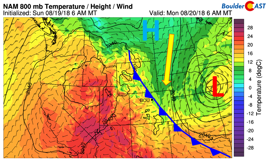
NAM 800 mb temperature from this morning across the West
What about that wildfire smoke we’ve been dealing with for the last two weeks? Below shows the HRRR model smoke forecast for this morning (left) and this evening (right). With the northerly flow, thick haze will again be a factor Monday as it will be bringing down more smoke from Montana and Wyoming. Much of the Pacific Northwest and Northern Rockies have Air Quality Alerts in place due to the unhealthy smoke levels.
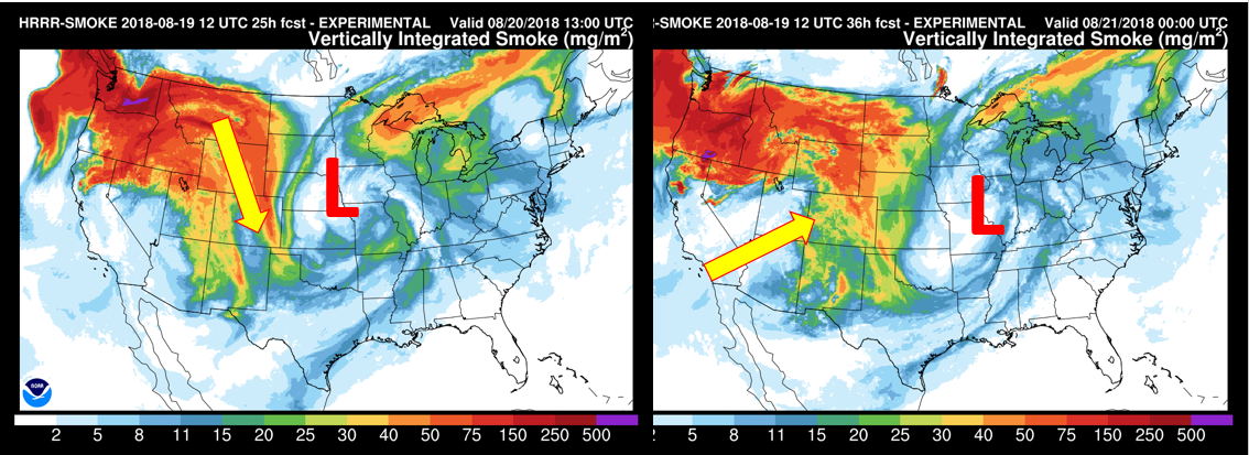
HRRR smoke forecast today
There are signs both in the models and in the large-scale pattern as we go through the week that improved visibility will take hold. As noted above on the right, southwest winds will build to our west and work in later tomorrow, Wednesday, and Thursday, which should help bring in “cleaner” air from southern California. Yes, it’s disheartening to think that the air in Los Angeles is actually cleaner than ours…
Chances for storms tomorrow, Wednesday, and Thursday
An increase in monsoonal moisture starting tomorrow will improve our chances of seeing another round of scattered showers and thunderstorms. It appears our best chance of storms this week will be on Tuesday. Now does this have anything to do with the fact that my parents are coming in town Tuesday?? Maybe…when they came in early September 2013, we had a certain flood and we all know how that ended up…
Putting that aside, Tuesday will see precipitable water values increase above average to around 1″ (see bottom right) thanks to the southwest flow redeveloping. At the same time, we may see some lift support from an upper-level jet streak oriented northwest to southeast from Wyoming into Missouri (left). That will put northeast Colorado in a favorable spot for supporting unsettled weather. Furthermore, another back-door cold front will be slipping into our region from the north. All of these factors will combine to bring a good chance of rainy weather Tuesday evening.
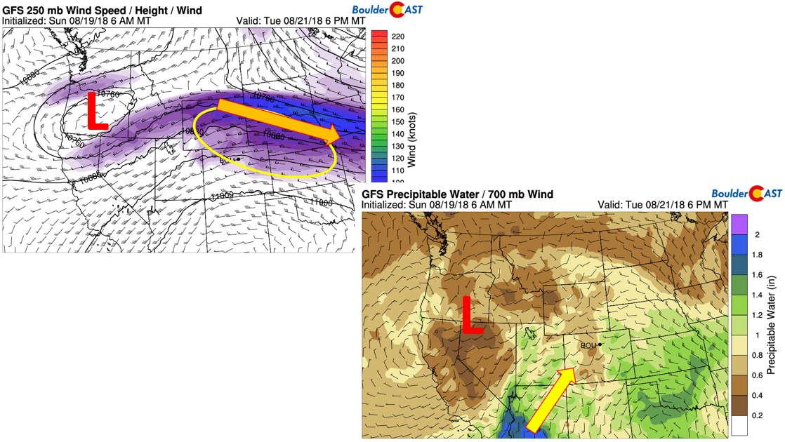
GFS 250 mb jet stream (left) and precipitable water (right) on Tuesday
Yet there exists differences in the models in terms of precipitation forecasts. The NAM and GFS (below) both have numerous showers and storms across the state, but disagreements center primarily on location. While overall instability is going to be low on Tuesday, we believe chances of rain and storms will be heightened enough for a 30-50% chance during the evening and overnight hours. Before that, highs should reach the middle 70’s. Storm chances return again Wednesday, although the pattern shifts slightly south of the Denver area. On Thursday, the approach of another cold front will continue the threat of rain, but probably just isolated in nature.
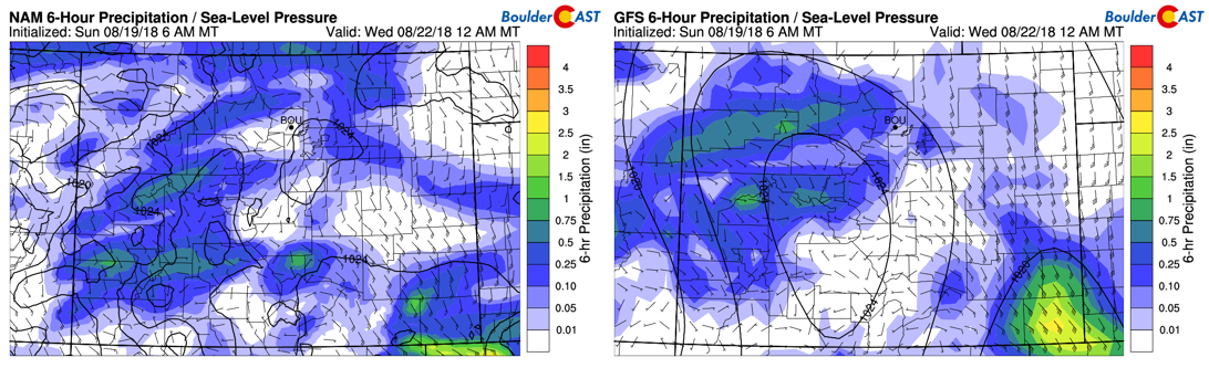
NAM (left) and GFS (right) precipitation forecast late Tuesday evening
As mentioned earlier, we are thinking that improved air quality will take hold as the week progresses. Below shows the NAM model 700 mb wind pattern across the CONUS on Wednesday. High pressure will be situated in west Texas, with low pressure in Idaho. These two pressure centers will create a southwest to northeast mid-level flow across the Four Corners region. That MIGHT help shift the smoke further north and out of our region. It may not leave completely, but we should see an improvement. The uncertainty lies in Thursday and Friday when northwest flow takes over with a cold front. This may return reduced visibility. However, we also see a general improvement in the long-term for the weekend.
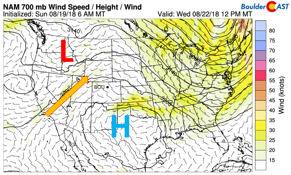
NAM 700 mb wind for Wednesday
Warmth returns late week
Thanks to a restrengthening of the westerly flow starting on Tuesday and peaking on Thursday, warmer temperatures will take hold, with highs slightly above average come Thursday and Friday in the mid to upper 80’s. Below shows the temperature pattern at 800 mb on Thursday. A lee trough axis is present in eastern Colorado, a typical signature for warmer weather.
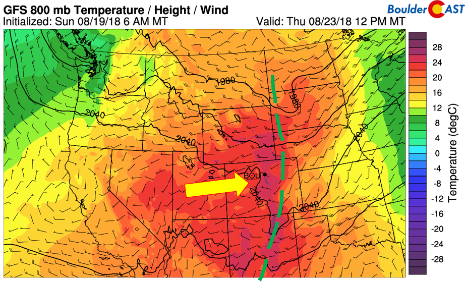
GFS 800 mb temperature on Thursday
Weekend looks warm with slight chance of storms
Come the weekend, it appears two large-scale systems will be factors in influencing our weather. The first is lower heights across western Canada. The second is weak high pressure over Texas. These are both evident below. If this pattern remains consistent in the models, the combination of these two systems will create a general southwesterly flow to our west. This SHOULD help alleviate wildfire smoke and increase visibility of the mountains…yay! In addition, it will keep us in that warm pattern with highs likely in the upper 80’s to lower 90’s. Finally, that southern push will also keep our area with a chance of storms thanks to a pathway from Baja.
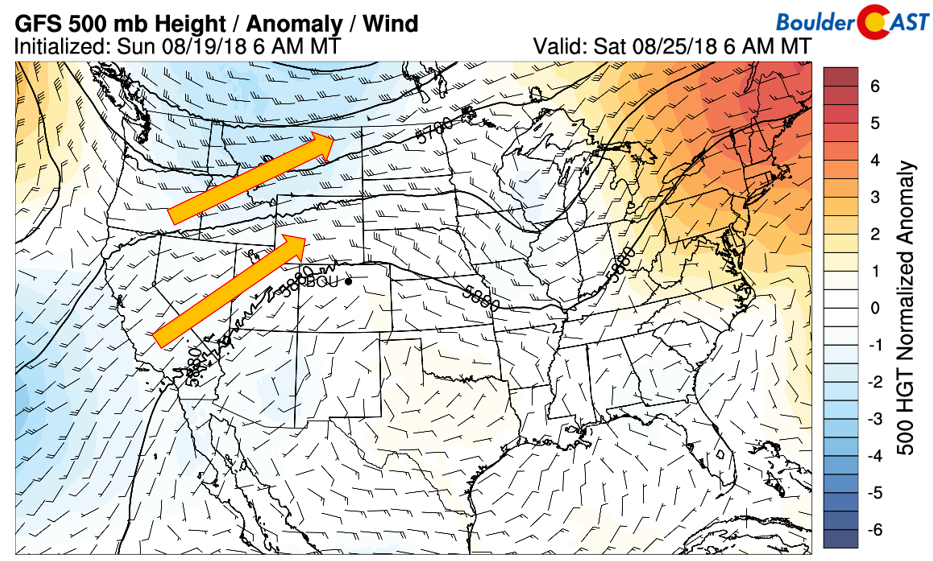
GFS 500 mb height anomaly for Saturday
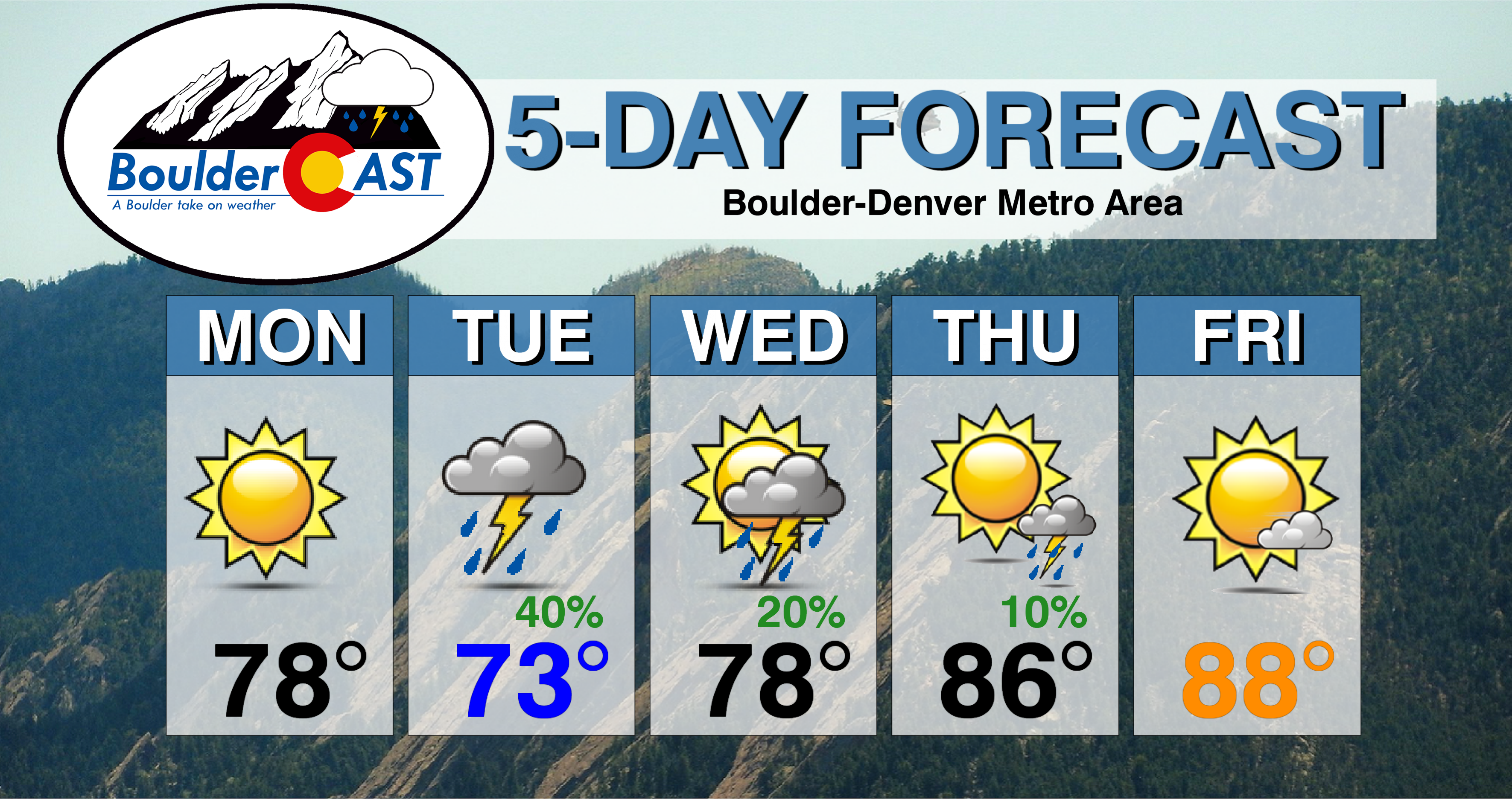
Forecast Specifics:
Monday: Mostly sunny and pleasant, but smoky. Highs in the upper 70’s across the Plains and upper 60’s in the Foothills.
Tuesday: Overcast skies and cooler. Showers and thunderstorms are possible in the late afternoon, evening and overnight hours. Some storms may produce heavy rainfall. High temperatures in the middle 70’s for the Plains with middle 70’s in the Foothills.
Wednesday: Mostly cloud in the morning, then partly cloudy skies with isolated thunderstorms in the afternoon and evening. High temperatures in the upper 70’s across the Plains with middle 60’s in the Foothills.
Thursday: Morning sunshine, then partly cloudy with isolated afternoon and evening thunderstorms, mainly south of Denver. Expect highs in the mid to upper 80’s for the Plains and in the mid 70’s in the Foothills.
Friday: Mostly sunny and seasonal. Look for highs in the mid to upper 80’s for the Plains with middle 70’s in the Foothills.
Weekend Outlook: Persistent southwesterly flow will keep the area in that warm pattern for late August with highs likely in the upper 80’s to low 90’s, along with a 10-20% chance of storm activity.
High Country: Scattered showers and storms will be across the Mountains Tuesday through Thursday, with drier weather expected today and Friday. Storm chances look to be in the 30-50% range tomorrow through Thursday. Check out our SummitCAST page for twice daily updated forecasts for more than 120 Colorado mountain destinations!
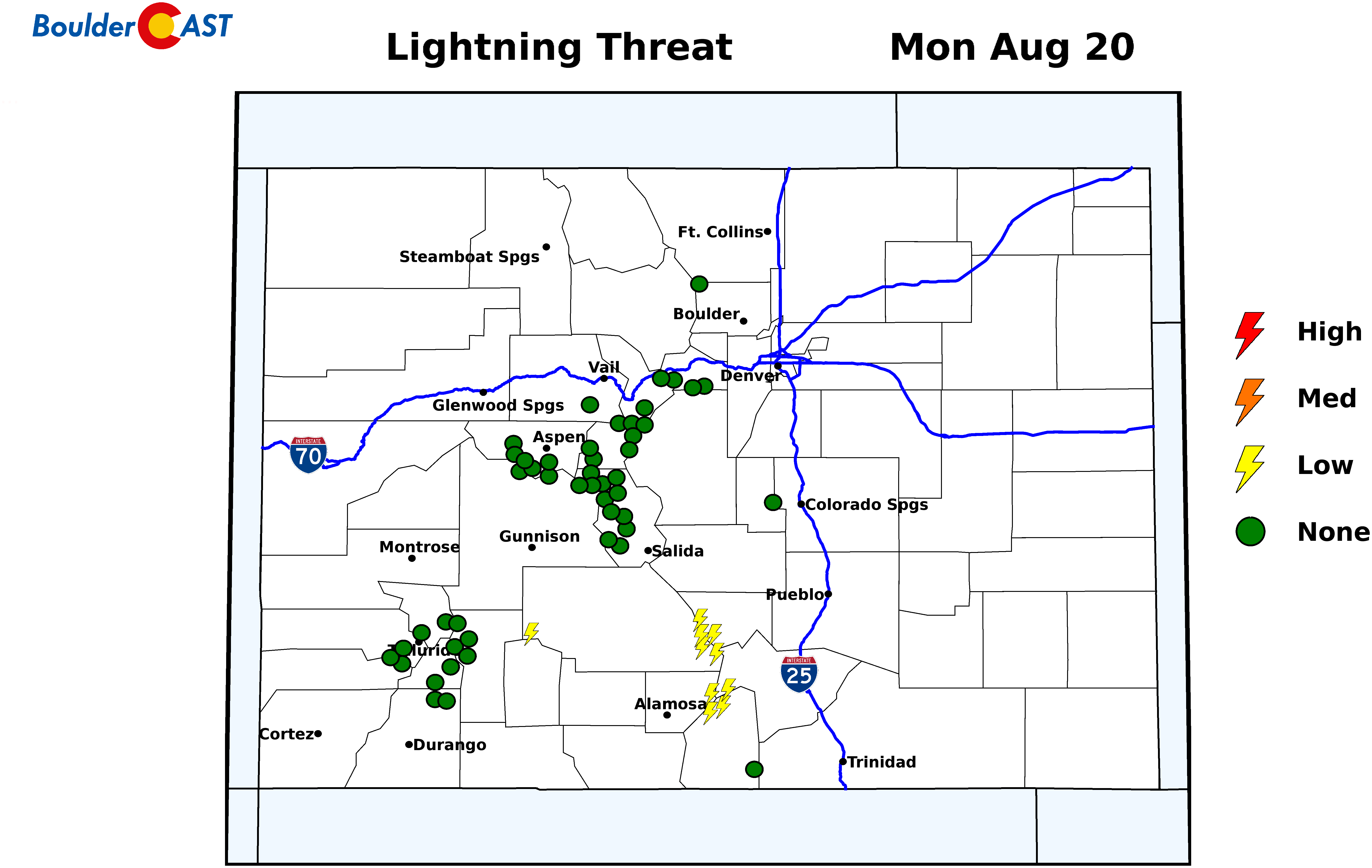
Lightning threat for Colorado’s 14ers on Monday.
DISCLAIMER: This weekly outlook forecast was created Monday morning and covers the entire upcoming week. Accuracy will decrease as the week progresses as this post is NOT updated. To receive daily updated forecasts, subscribe to BoulderCAST Premium.

.
Share our forecast!


You must be logged in to post a comment.