This week’s weather kicks off with a dramatic autumn shift—widespread rain, clouds, and a serious temperature drop that will bring snow to the High Country. A strong cold front and upper-level system will make Tuesday feel more like late October, with highs stuck in the lower 50s. But don’t worry, sunshine and warmth are on the horizon again. By midweek, we’ll rebound into the 60s and maybe even flirt with 80 by Friday. Curious about how much soaking rain we’ll get—or where that snow might land? Read on for all the details.
This week’s highlights include:
🌧️ Stormy Start: A mid-level circulation dropping in from Wyoming will trigger rain, chilly temps, and even High Country snow through Tuesday, with a surface low and strong cold front enhancing the impact.
🌬️ Cold Front Arrival: The front moves through Monday night, bringing upslope flow, widespread clouds, and a sharp drop in temperatures.
☔ Rain Timeline: Scattered showers begin Monday afternoon (2–10PM), followed by steady overnight rain into Tuesday; totals range from 0.5″ to 1.0″, with isolated spots possibly seeing 1.5″+.
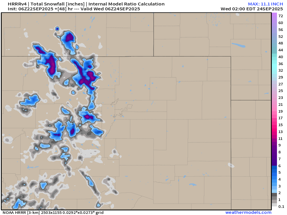
❄️ Snow Potential: Light snow may accumulate in the Mountains above 10,000 feet, with visible snow on Divide like Longs Peak by Wednesday.
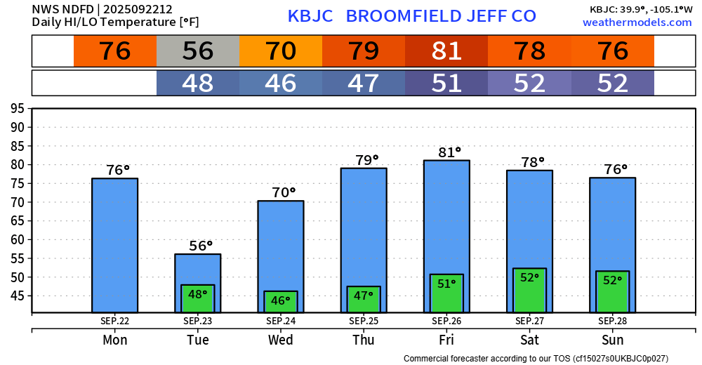
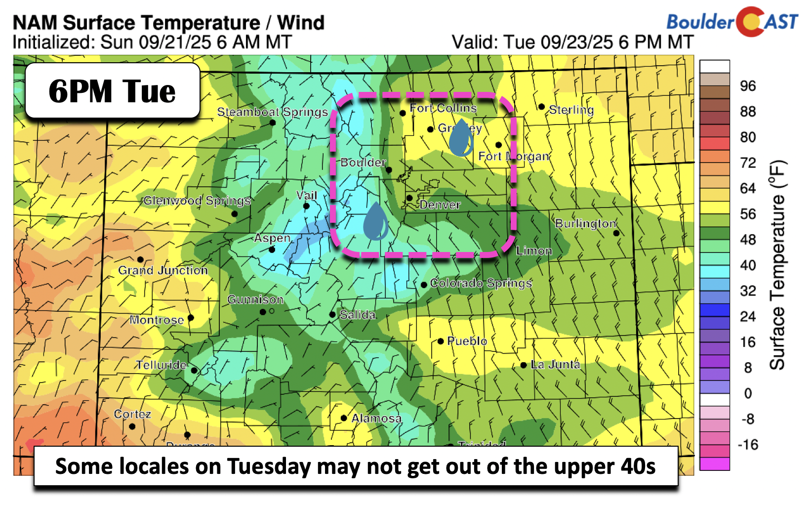
🌫️ Tuesday Outlook: Expect a cold, wet, and foggy day with highs struggling to reach the low 50s—20+ degrees below seasonal norms.
🌤️ Midweek Rebound: High pressure returns Wednesday, clearing skies and warming temps into the 60s and 70s, reaching near 80 by late week.
DISCLAIMER: This weekly outlook forecast is created Monday morning and covers the entire upcoming week. Accuracy will decrease as the week progresses as this post is NOT updated. To receive daily updated forecasts from our team, among many other perks, subscribe to BoulderCAST Premium.

Go Premium, get all the perks.
Daily Forecast Updates
Get our daily forecast discussion every morning delivered to your inbox.
All Our Model Data
Access to all our Colorado-centric high-resolution weather model graphics. Seriously — every one!
Ski & Hiking Forecasts
6-day forecasts for all the Colorado ski resorts, plus more than 120 hiking trails, including every 14er.
Smoke Forecasts
Wildfire smoke concentration predictions up to 72 hours into the future.
Exclusive Content
Weekend outlooks every Thursday, bonus storm updates, historical data and much more!
No Advertisements
Enjoy ad-free viewing on the entire site.
A Wet and Chilly Start to the Week
Get ready for a soggy and unsettled kickoff to autumn, with temperatures taking a noticeable dip by Tuesday. In fact, if you’re headed into the High Country, it will be cold enough to support more than a few snowflakes flying around. But hang in there—by midweek, we’ll flip the script with drier conditions and more typical late-September warmth.
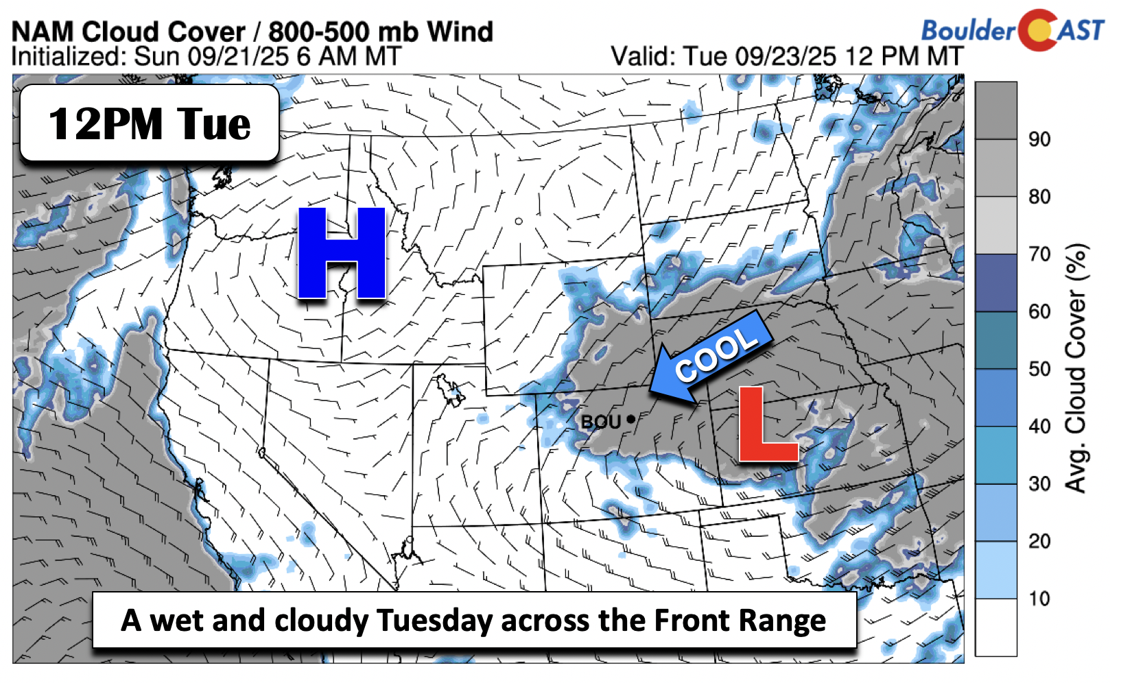
This shift in the weather is being driven by a mid-level circulation currently spinning over Wyoming. That system is pulling in moisture and creating lift, which will start ramping up Monday afternoon and continue well into Tuesday across our area.
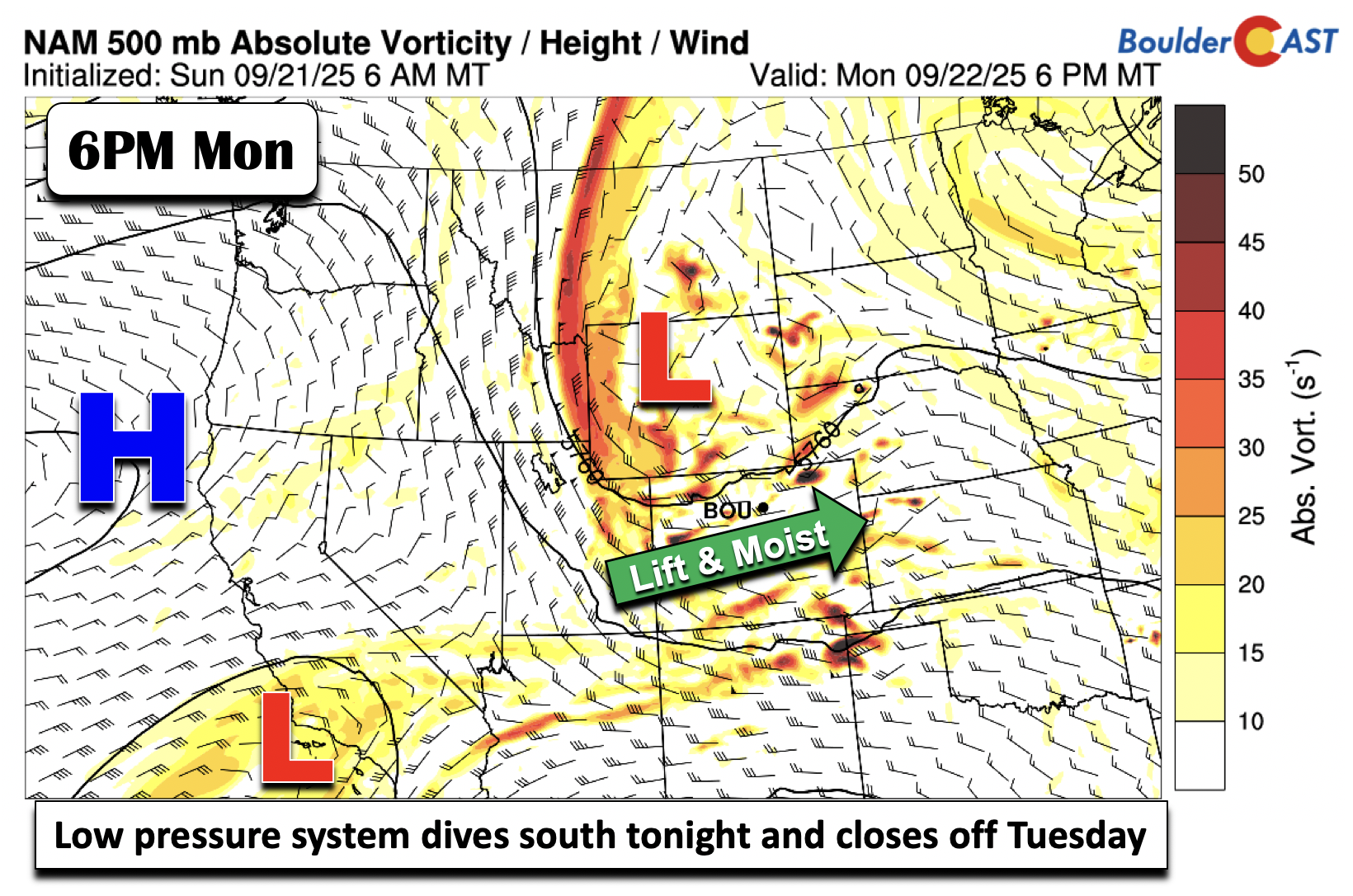
The low-pressure center is expected to drop south into central Colorado and evolve into a closed system. It’ll linger through Tuesday night before finally pushing eastward by early Wednesday.
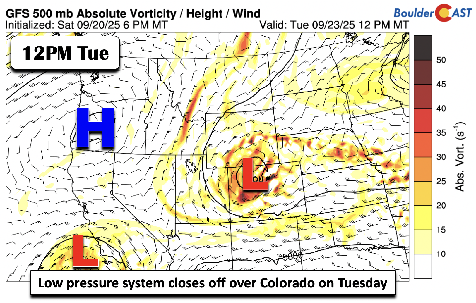
At the surface, a reflection of that mid-level system will develop along a strong cold front. That front will sweep through Monday night, ushering in a much colder air mass for Tuesday.
Rain chances pick up this afternoon, with scattered to widespread showers moving west to east from the mountains onto the Front Range. The prime window for this activity is between 2PM and 10PM. Most areas will see between 0.10″ and 0.25″ of rain, though some spots could get a bit more or less. Severe weather isn’t expected locally, as the instability axis stays east near the Colorado-Kansas border.
Later tonight, expect more widespread light to moderate rain as the upper low settles in. Monday will be our last mild day for a bit, with highs in the mid to upper 70s.
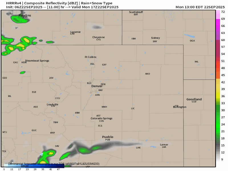
HRRR model-simulated radar animation for Monday and Tuesday in the Front Range
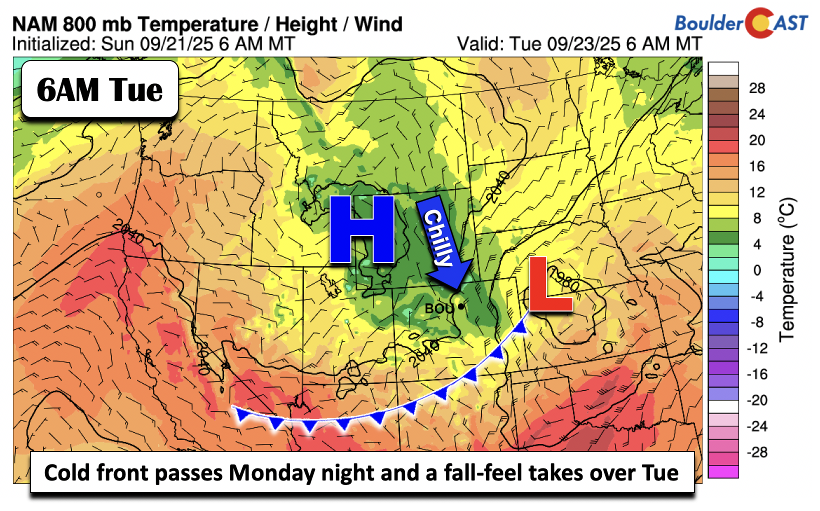
Once the cold front rolls through overnight, Tuesday will feel downright raw. We’re talking chilly, damp upslope flow, thick cloud cover, and drizzle. By Tuesday afternoon, the low-level center will be over western Kansas, with high pressure building in from Idaho. That setup will drive a strong northeast wind across the Denver Metro and Foothills. Higher elevations could even see sub-freezing air aloft—pretty unusual for this time of year.
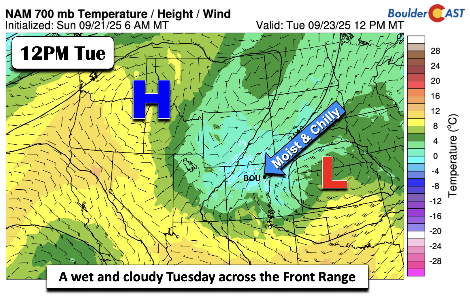
By Tuesday, wrap-around moisture from the upper low and upslope winds will keep light to moderate rain and drizzle going throughout the day. Expect widespread low clouds and fog. And temperatures? They’ve been trending colder in recent model runs. Earlier forecasts had us in the 60s, but now it looks like we’ll struggle to get out of the low to mid 50s. Some models even suggest upper 40s. That’s 20+ degrees below normal!
Clouds will likely stick around into early Wednesday, but sunshine should gradually return as high pressure nudges in and the storm system shifts toward the Midwest.
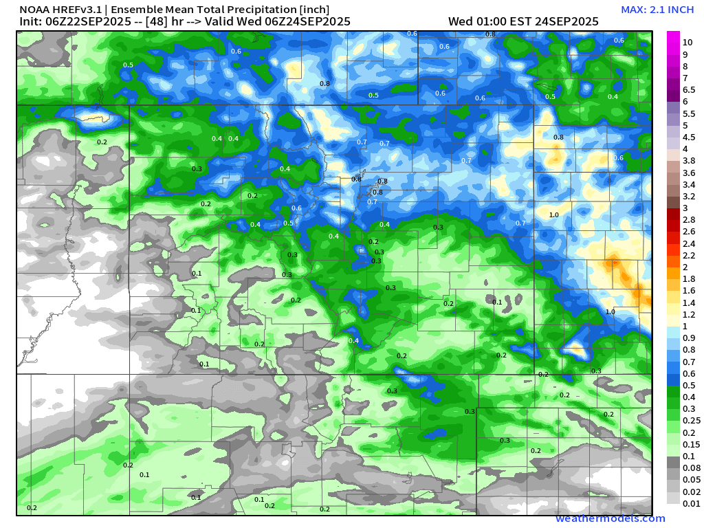
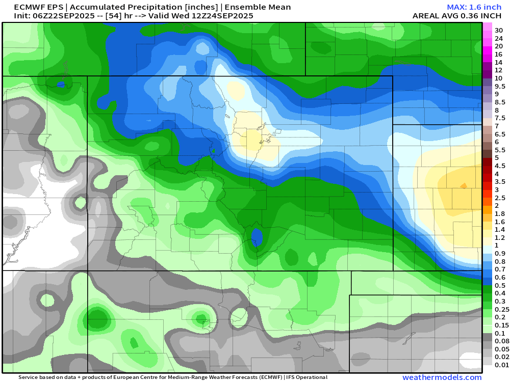
Rainfall Totals: Still Some Uncertainty
Models are split on where the heaviest rain will fall. Some place it just north and east of Denver/Boulder, while others (like the ECMWF) bring it right over the Front Range. The NAM model lands somewhere in between. Regardless, most areas should see between 0.5″ and 1″ of rain. There’s even a chance some spots could pick up 1.5″ to 2″+, though that’s less certain. Because of this, the Weather Prediction Center has issued a marginal risk for excessive rainfall.
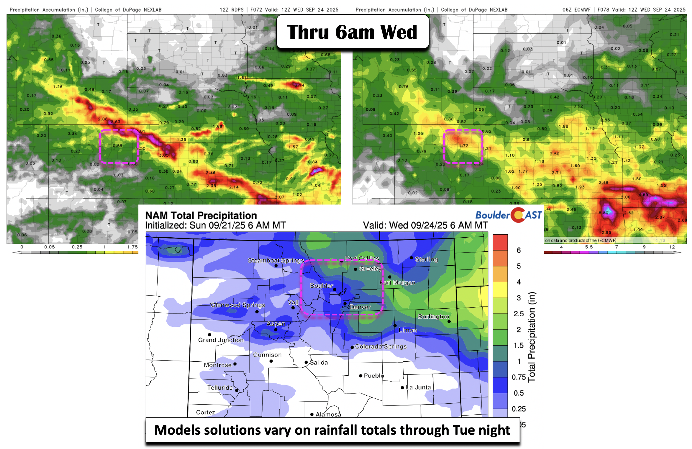
With such cold air aloft, we can’t rule out accumulating snow above 10,000 feet. On Wednesday, once the clouds clear, you will almost certainly be able to catch a glimpse of fresh snow on Longs Peak and the Divide!
Midweek Turnaround: Drying Out and Warming Up
By Wednesday afternoon, high pressure will help clear out the moisture. After a chilly Tuesday, we should rebound into the mid to upper 60s.
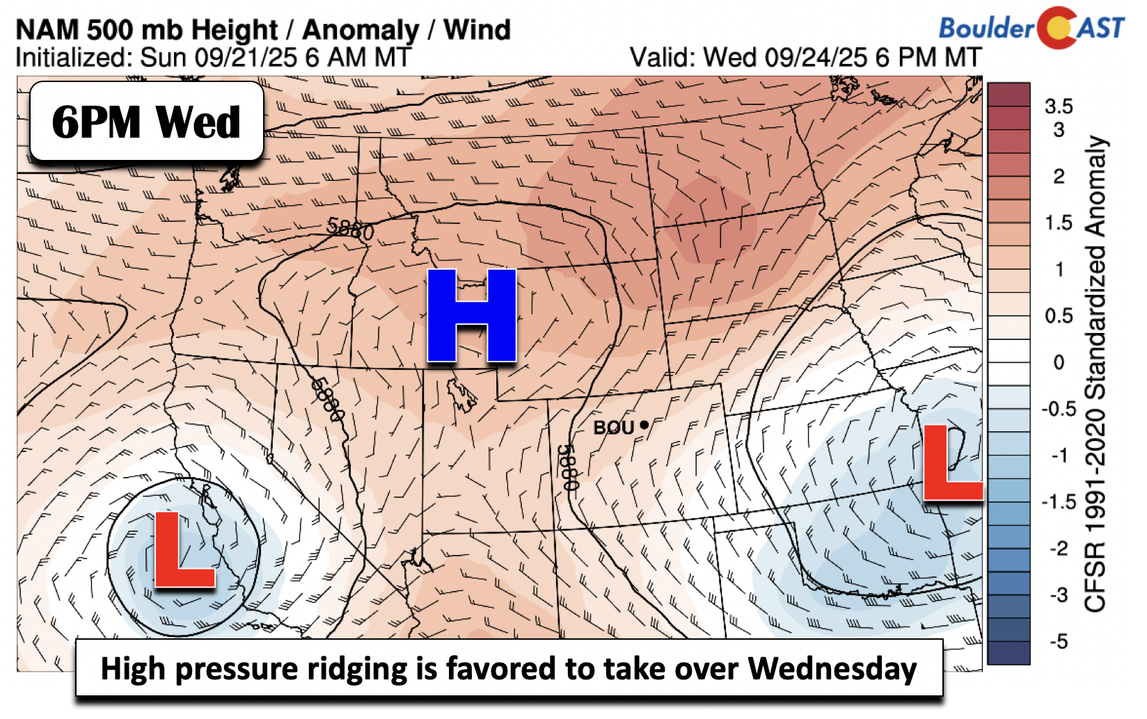
Thursday looks even better, with highs climbing back into the mid 70s. Most models keep high pressure in control through the end of the week, though a closed low could flirt with the region. For now, ensemble guidance keeps it south and west of us.
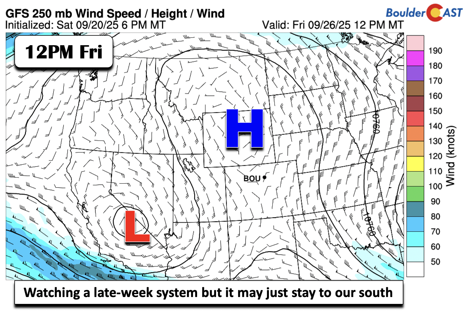
By Friday, we could be pushing 80 degrees—a dramatic turnaround from the 40s and 50s earlier in the week!
Happy first day of autumn!
![]()
Forecast Specifics:
Monday: Partly cloudy with increasing clouds. Then scattered to numerous showers will develop, mainly after 2PM. Some rumbles of thunder possible. Chance of rain 50%. Widespread rain will develop later tonight and continue into Tuesday. Highs in the upper 70s on the Plains and upper 60s in the Foothills.
Tuesday: Cloudy, chilly, damp, and wet with periods of light to at times moderate rain. Some fog also possible. Chance of rain 90%. Highs in the low to mid 50s on the Plains and upper 30s to low 40s in the Foothills.
Wednesday: Morning clouds and fog, followed by afternoon sunshine. Highs in the mid/upper 60s for the Plains and mid/upper 50s for the Foothills.
Thursday: A bit warmer and sunny with middle to upper 70s on the Plains and middle 60s in the Foothills.
Friday: Likely dry but cannot rule out a slight shower chance. Slightly above normal with upper 70s to near 80 for the Plains and upper 60s in the Foothills.
Weekend: Staying seasonal to slightly above normal with highs in the middle to upper 70s. There could be a few shower chances as well but with low confidence at this time.
DISCLAIMER: This weekly outlook forecast is created Monday morning and covers the entire upcoming week. Accuracy will decrease as the week progresses as this post is NOT updated. To receive daily updated forecasts from our team, among many other perks, subscribe to BoulderCAST Premium.
Go Premium, get all the perks.
Daily Forecast Updates
Get our daily forecast discussion every morning delivered to your inbox.
All Our Model Data
Access to all our Colorado-centric high-resolution weather model graphics. Seriously — every one!
Ski & Hiking Forecasts
6-day forecasts for all the Colorado ski resorts, plus more than 120 hiking trails, including every 14er.
Smoke Forecasts
Wildfire smoke concentration predictions up to 72 hours into the future.
Exclusive Content
Weekend outlooks every Thursday, bonus storm updates, historical data and much more!
No Advertisements
Enjoy ad-free viewing on the entire site.
Enjoy our content? Give it a share!


You must be logged in to post a comment.