For the second week in a row, rather quiet and warm late-summer (and dare we say…early fall) conditions with exist across the Front Range. We’ve only got one slight chance of rain to talk about. Otherwise, we’ll see drought conditions worsen and wildfire smoke linger across the area.
This week’s highlights include:
- Not one, but two centers of high pressure will dominate our weather pattern this week
- Temperatures in the 80’s and mostly dry conditions will prevail through the weekend
- Our only chance of rain comes Tuesday as a weak disturbance passes across Colorado
- Smoke will linger across the area through the entire week with fluctuating intensity

DISCLAIMER: This weekly outlook forecast is created Monday morning and covers the entire upcoming week. Accuracy will decrease as the week progresses as this post is NOT updated. To receive daily updated forecasts from our team, subscribe to BoulderCAST Premium.

Warm, smoky & mostly dry as the drought worsens
On this glorious Monday morning the mid-latitude storm track sits along the United States and Canada border. The jet stream has been slowly creeping southward with the changing seasons, but as it stands this week, its location will keep most of the unsettled weather well to our north. Elsewhere across the country, high pressure is the storyline with with four separate centers present and accounted for (shown below). Meanwhile, Tropical Storm Beta continues to spin off the Texas coast bringing heavy rainfall to that region and some gusty winds.

As the week progresses, high pressure over Colorado will push eastward, only to be replaced by a secondary ridge building into the area from the southwest late in the week (animated below). The result will be a continuation of the warm and mostly dry conditions we’ve had over the last ten days. Highs will stay in the 80’s (or better) across the region through Friday.

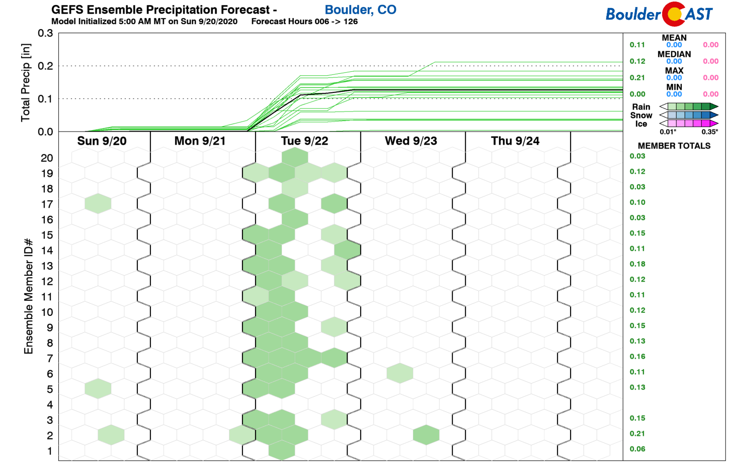
Our only chance of rain for the week will be Tuesday afternoon and evening as a very subtle shortwave scoots across the area in the brief window between ridges. This wave will impact our area during the day Tuesday leading to widely scattered showers and a few thunderstorms. Most areas will be dry and any showers will be brief and provide just light to moderate rainfall.
Late Friday into Saturday we are anticipating a Pacific trough which could potentially edge far enough south to clip northern Colorado. This trough has been something we have been watching for a while with hopes that it could bring fall-like weather to the area. Lately, though, models have trended weaker, faster and further north with this storm. While there may not be any precipitation associated with this system for us, it should sling a cold front our way Friday night or sometime Saturday. This will likely end our lengthy stretch of 80+ degree days which began on September 12th (just three days after the historically early snow!). We’re expecting highs to drop back into the 70’s for the weekend. This is right around normal for late September in the Boulder area.

So where does this warm and dry week leave us? Well, for one…with worsening drought conditions. A large portion of the Metro area has been “upgraded” to the “Extreme Drought” classification by the US Drought Monitor.

Secondly, this week will entertain lingering smoke from the plethora of active wildfires burning across the West.

A new fire sparked this past weekend just over the border in Wyoming. It’s called the Mullen fire and much of the smoke we see early in the week will be a directly from that fire. We’re not expecting any major relief from the smoke in the near-term, though in general smoke levels will be more tolerable with PM2.5 air qualities ranging from 50 to 100 much of the week (which is below unhealthy thresholds).

HRRR-Smoke model forecast for near-surface smoke content on Monday and Tuesday this week
Finally, don’t forget to submit your prediction for our SECOND Snowfall Contest. The contest closes to entries Thursday night (9/24) at midnight!
We’ll conclude this week’s outlook with a photo we took over the weekend that well depicts the current drought conditions and smoky skies across the area. It’s bleak out there, folks. Have a good week!
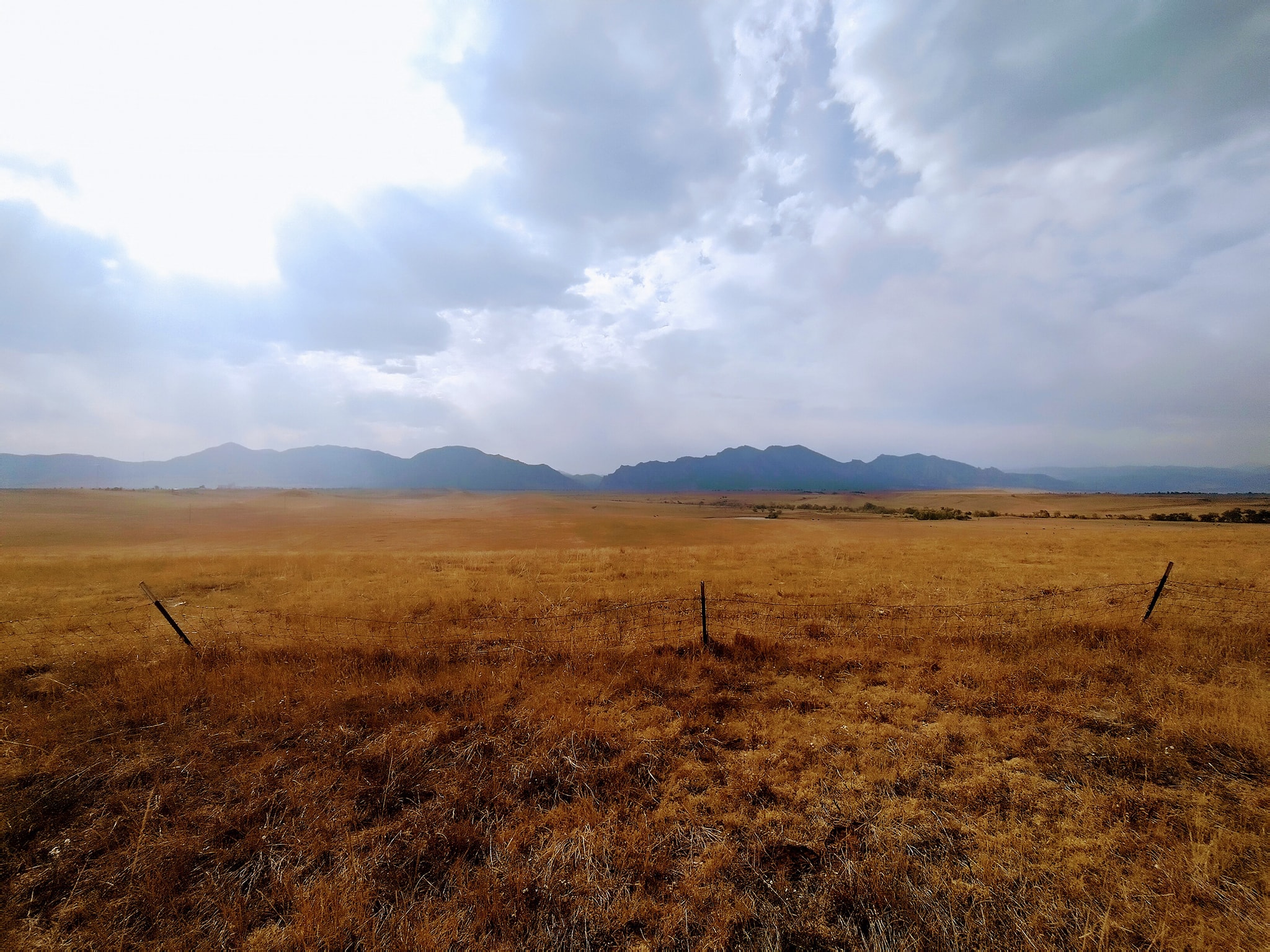
The smoky, hazy and drought-stricken prairie of Front Range Colorado, as see from Rocky Flats on Saturday 9/19/20.
Forecast Specifics:
Monday: Morning sunshine and smoky, then partly cloudy with highs in the middle 80’s on the Plains and low 70’s in the Foothills.
Tuesday: Partly to mostly cloudy with widely scattered afternoon and evening thundershowers, most numerous across the higher terrain. Highs in the middle 80’s on the Plains and lower 70’s in the Foothills.
Wednesday: Partly cloudy and dry. Temperatures in the middle 80’s on the Plains and lower 70’s in the Foothills.
Thursday: A few morning clouds, then mostly sunny and warm with highs in the upper 80’s on the Plains and middle 70’s in the Foothills.
Friday: Lots of sun and hot with highs near 90 degrees on the Plains and upper 70’s in the Foothills.
Weekend: Temperatures will be slightly cooler over the weekend in the 70’s following a dry cold front, but it will be very pleasant. Not bad for the first weekend of autumn!
High Country: Another seasonably warm week will also unfold across the Mountains with relatively warm and dry conditions. There will be a slight chance of isolated storms on Monday and scattered thunderstorms on Tuesday. After this, it will be mostly dry with increasing wind speeds aloft late in the week with the approaching Pacific storm system. Check our SummitCAST page for daily updated forecasts for more than 120 mountain hiking destinations across Colorado.

Help support our team of Front Range weather bloggers by joining BoulderCAST Premium. We talk Boulder and Denver weather every single day. Sign up now to get access to our daily forecast discussions each morning, complete six-day skiing and hiking forecasts powered by machine learning, first-class access to all our Colorado-centric high-resolution weather graphics, bonus storm updates and much more! Or not, we just appreciate your readership!
.
Spread the word, share the BoulderCAST forecast!
.


You must be logged in to post a comment.