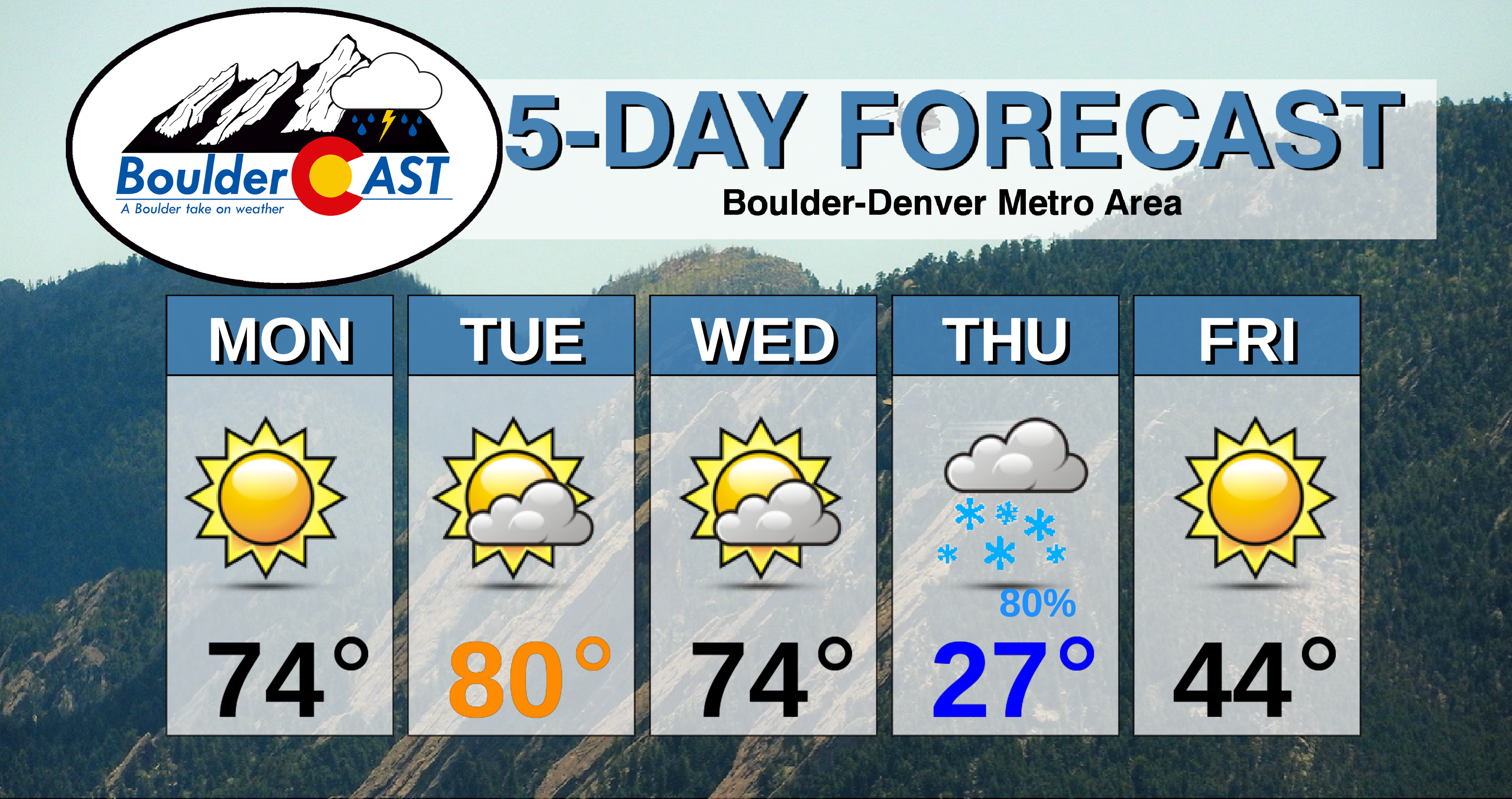
This week begins on the warm side, but temperatures will take a major tumble as our first taste of winter arrives Wednesday night into Thursday. Our forecast calls for the first accumulating snow of the season and potentially record cold temperatures. Read on for more details.
Mild to start the week
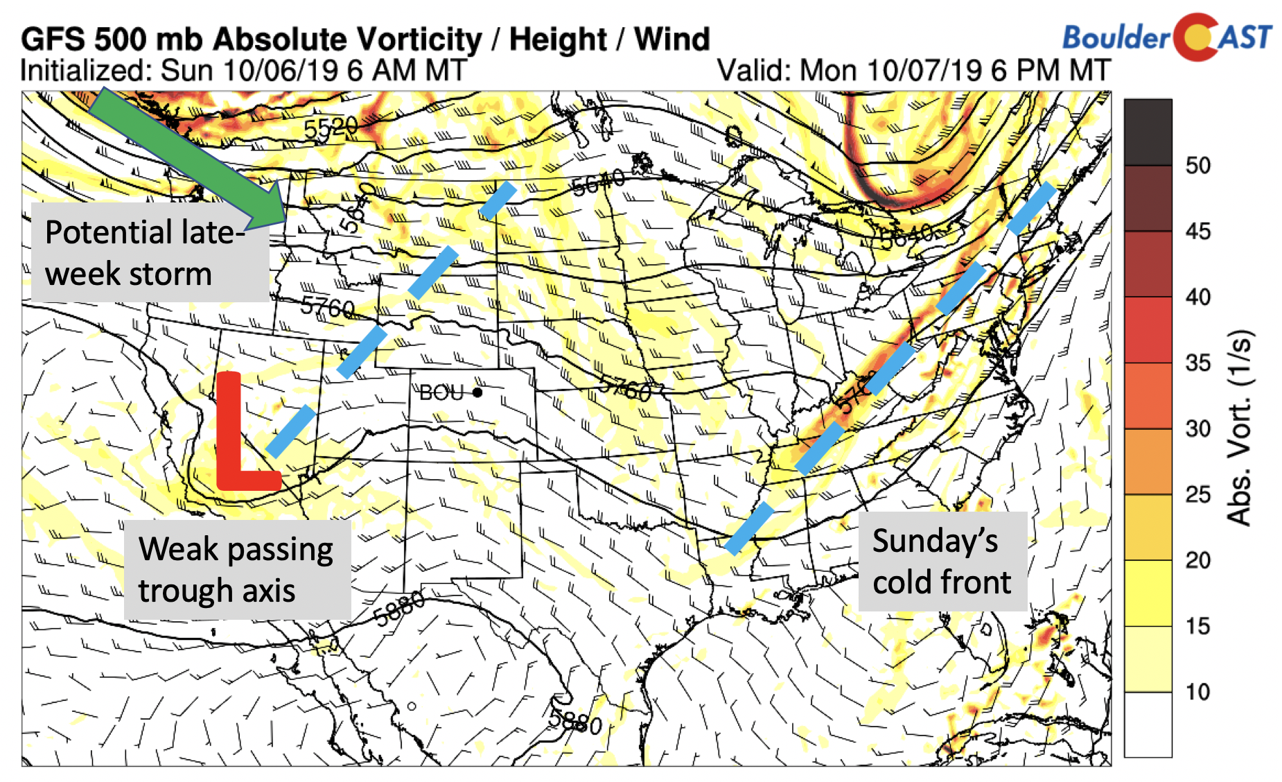
The weather this week is summarized below with the mid-level 500 mb absolute vorticity map for the nation. Yesterday’s cold front has pushed off into the eastern U.S. There is a weak trough across southern California that will bring only clouds for us on Tuesday. Further to our northwest in Alaska, just off the edge of the map, there are the beginnings of a winter storm taking aim on our region Wednesday night and Thursday. Monday’s weather will be rather tranquil with high pressure holding strong. Expect lots of sunshine and highs in the lower 70’s in most areas, with a few middle 70’s toward Denver.
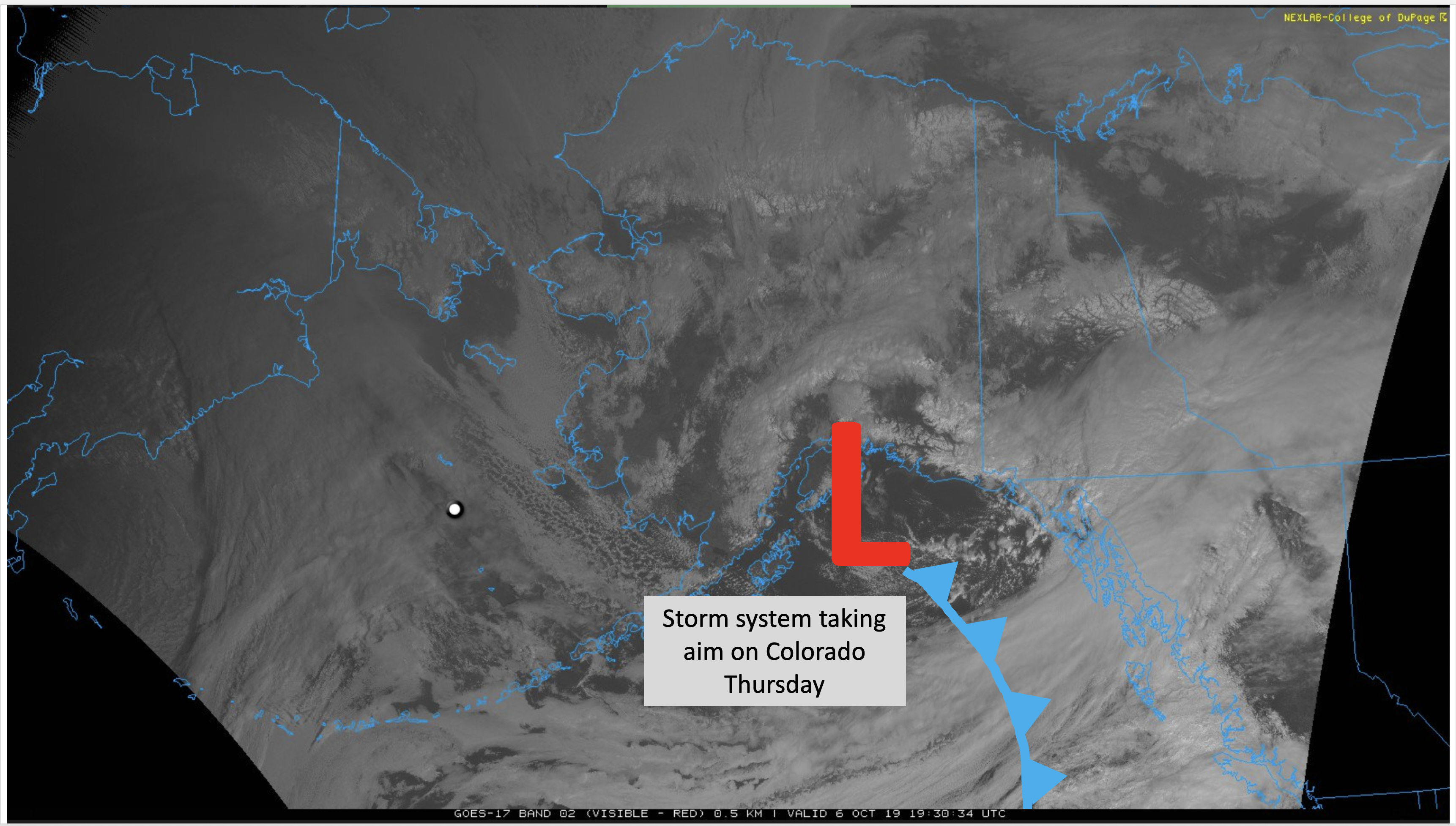
The wintry system that will be a player later in the week is currently located near the Gulf of Alaska today and is seen on visible satellite image below. It’s hard to believe, but this storm will be in Boulder by Thursday morning!
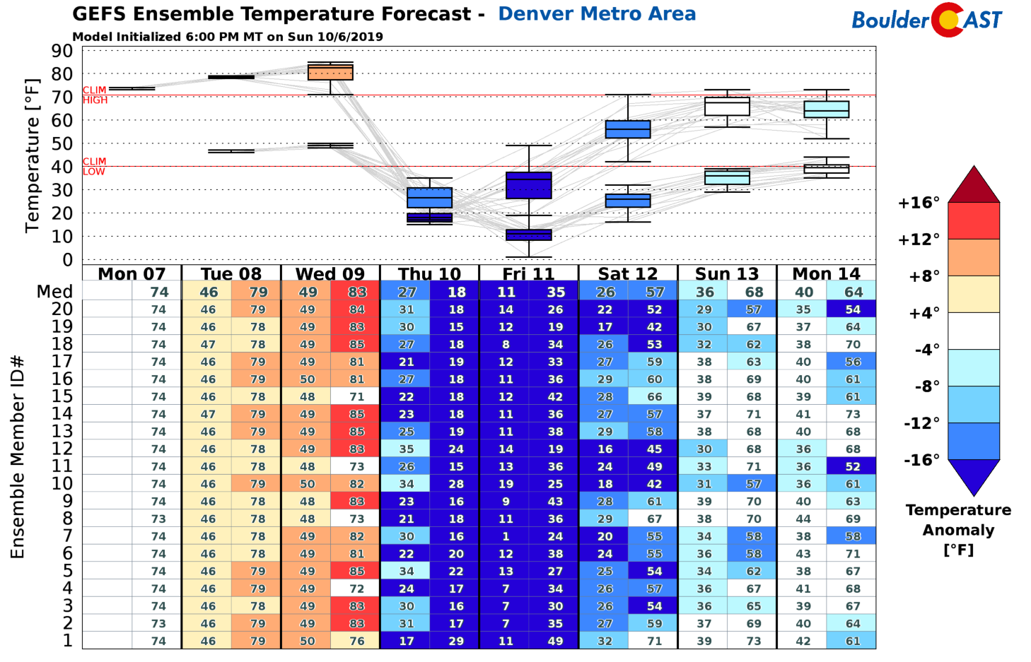
Despite the mild start, a big wake-up call is coming mid-week! This is quite evident in the GEFS ensemble temperature forecast below. Note the toasty temperatures in-place through Wednesday (warm colors). After that, temperatures plunge as the prolific cold front arrives. Some of the ensemble members have daytime highs in the teens on Thursday and single digit lows Thursday night. We likely won’t be that cold, but suffice to say, you’ll definitively notice the change!
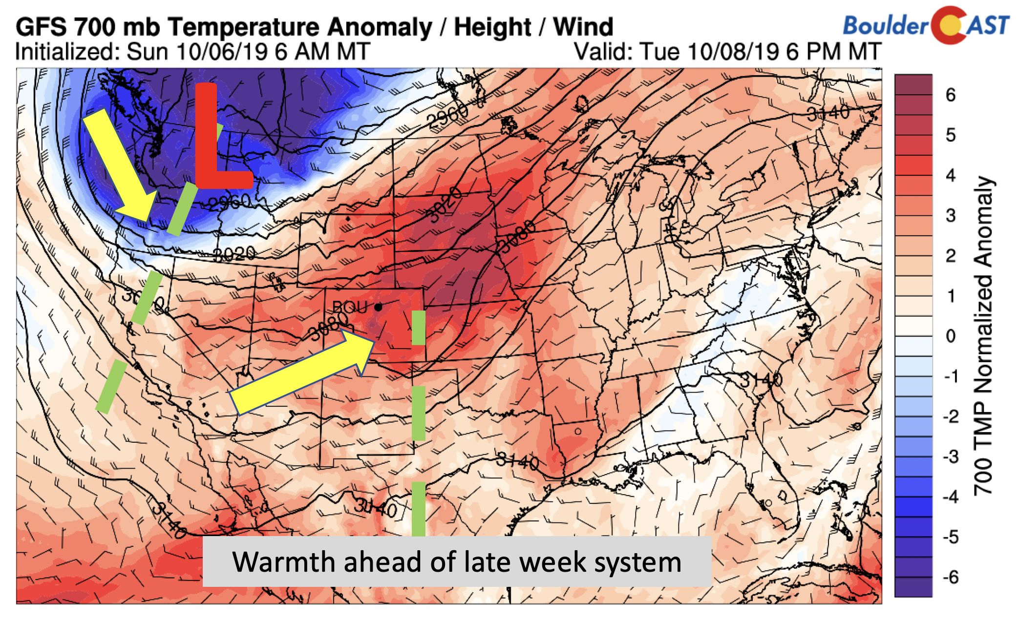
Tuesday’s forecast will continue the rise in temperatures from Sunday as southwest winds advect in a warm airmass for the area and in fact, much of the entire Great Plains (below). Highs should not have an issue getting into the upper 70’s in most locales. A brief touch at 80 degrees is not out of the question, but is harder and harder to come by with the shorter days this time of year. Outside of a few wave clouds spurred on by the trough axis, mostly sunny skies are expected.
A taste of winter Wednesday night
Wednesday will commence very similar to Tuesday, but will end markedly different. A strong cold front will be knocking on our door by late afternoon or early evening, depending on the timing of the front. As a result, highs should remain rather warm early on in the middle 70’s. This will be followed by a dramatic drop in temperatures into the evening and overnight tumbling quickly into the 20’s. It’s possible highs on Wednesday may be a tad warmer if the front is slower, but we are hedging for a faster frontal passage as models usually are too sluggish in these circumstances.

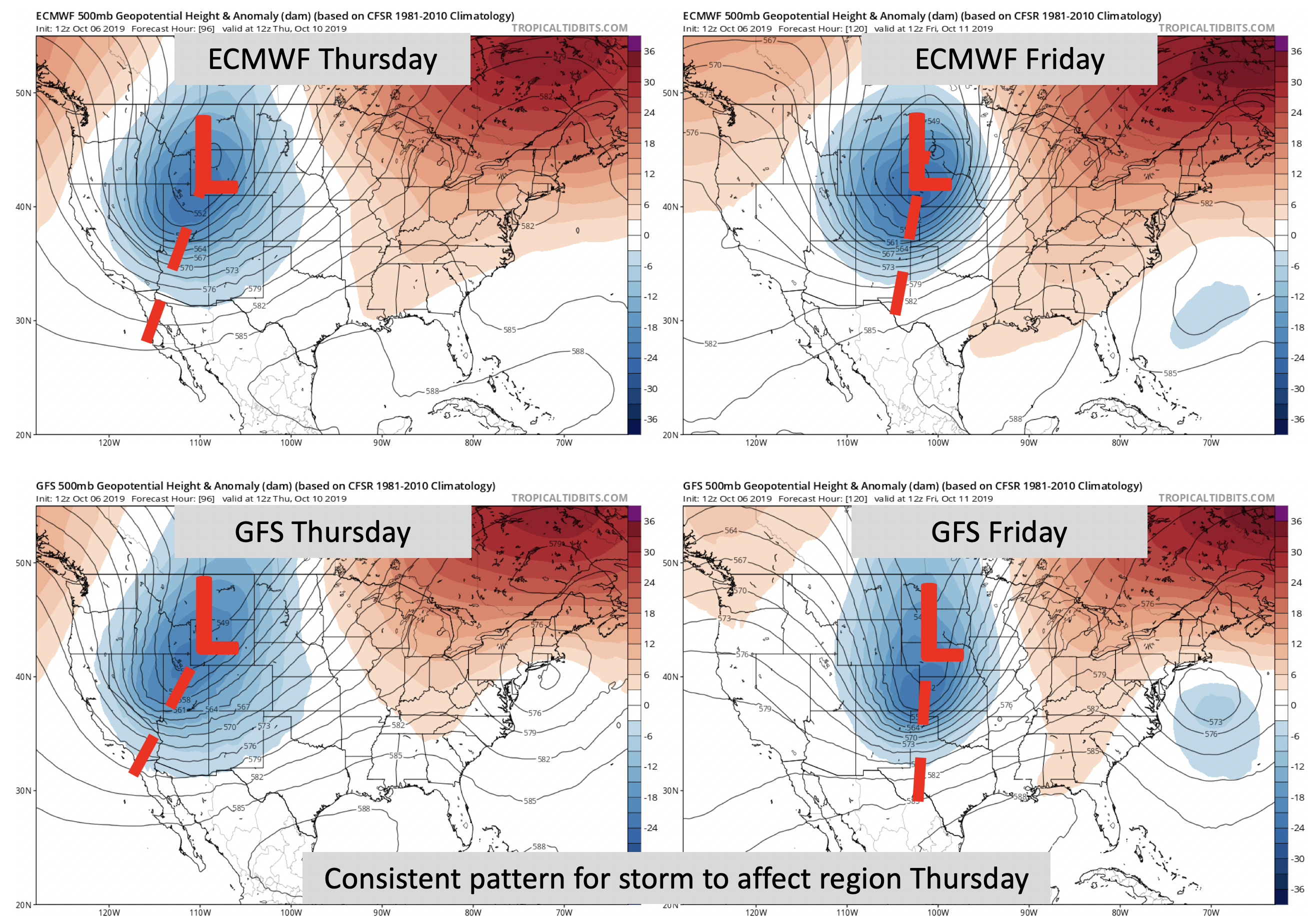
Overall, there is remarkably good agreement between the global forecast models for the incoming storm. Not bad considering it’s still in Alaska. The below panels show the mid-level 500 mb height anomaly pattern from the European and GFS models on Thursday (left figures) and Friday (right figures). Note that both models show a positively tilted trough to our west early Thursday, with the center of the system in Wyoming. On Friday, the two models show the trough on its way out, with the center of low pressure in Nebraska or South Dakota. There are some differences, however, with the GFS indicating more of an open wave and extending slightly further south into the panhandle of Texas. These differences are likely to resolve themselves in the next day or so. Nonetheless, signs point to a near-certainty of our first snowfall of the season!
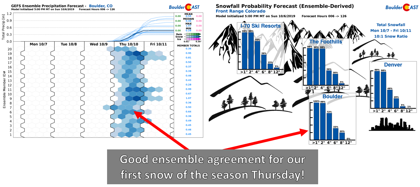
Even the GEFS ensemble precipitation forecast shows good consistency for over 0.3″ of liquid on Thursday (below left). This would be all snow given the unseasonably cold airmass. The BoulderCAST snowfall probabilities (bottom right) are showing a 100% chance for 1-2″ of snow in both Boulder and Denver, with possibly a few inches more on the table as well (more on this in a minute).
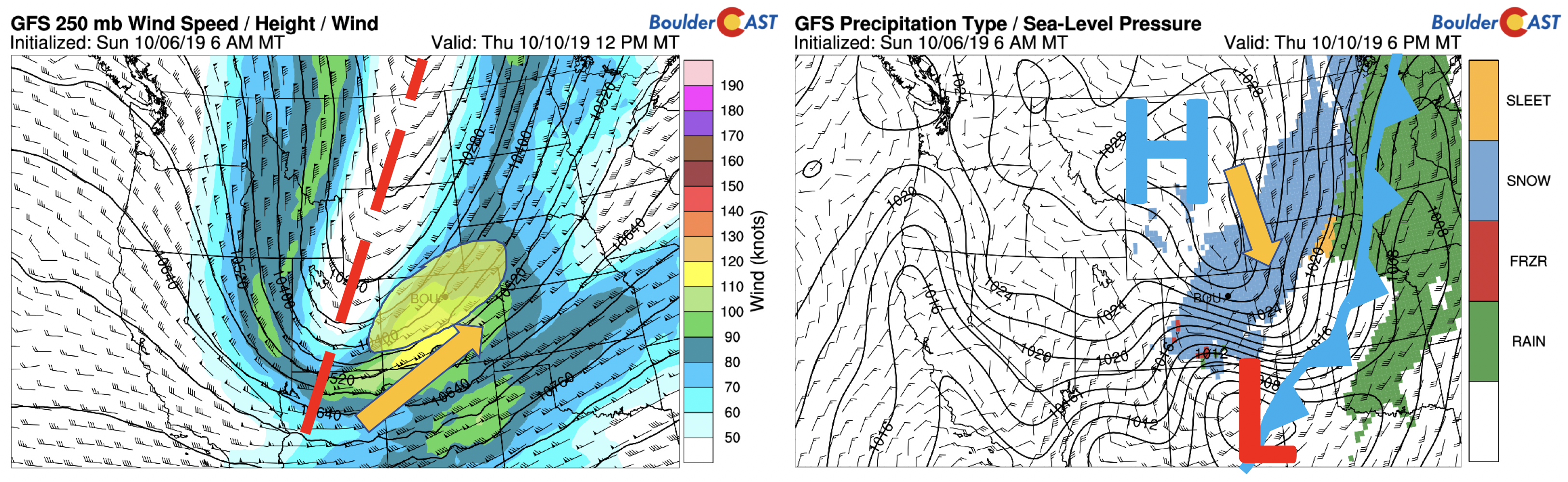
Another key aspect to watch will be the overhead jet stream. Depending on how the storm evolves as it tracks over the state, it may put the Front Range in a favorable region of upper-level lift tied to the left-exit region of the jet stream (below on the left, the yellow shaded region). As you know, we need to keep close tabs on the jet as it can produce areas of heavy banded snowfall. The GFS model is definitely picking up on this potential, painting a large swath of moderate to heavy snow over northeast Colorado (below right). The presence of the jet and the associated uncertainty is likely the cause of the significantly higher snow amounts showing up in the ensembles. Thus, this is something we will closely monitor in the coming days.
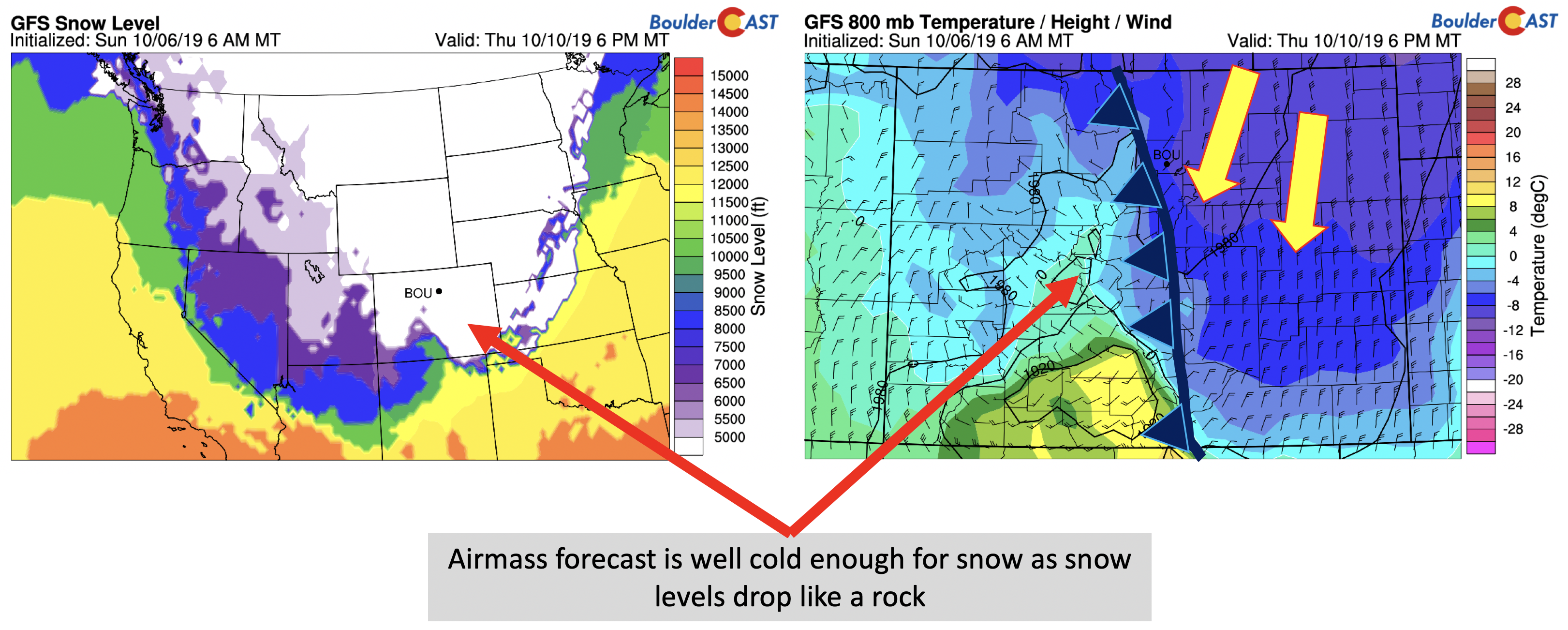
We continue to stress that the fine-scale details still need to be ironed out, but certainly the track is looking favorable for us. The airmass will be plenty cold…near surface temperatures in the 20’s on Thursday…with a marginal upslope flow expected. Snow levels will be way below 5000 feet so precipitation type will not be an issue here. The exact upslope strength, storm track, and position of the jet will be vital players in how much snow we actually get. Our preliminary forecast calls for 1 to 4″ of snow across the Boulder and Denver Metro areas. These amounts will be fine-tuned in the coming days so check back for updates.
The final aspect of the wintry forecast worth discussing are the very cold temperatures. Thursday night’s lows could drop well into the teens, and possibly single digits if skies fully clear with fresh snow on the ground. The record low temperature in Boulder on Friday is 20 degrees, which should easily be surpassed. Temperatures this cold would be enough to freeze all plant-life and above ground and exposed pipes. Now is the time to prep your irrigation systems for winter!
Finally, Friday will be a chilly one as well with highs in the 40’s, but with a gradual turn towards more sunshine and calmer weather, the snow will quickly be melting.
Enjoy the warmth while it lasts, and for the snow-lovers, Thursday is YOUR day!

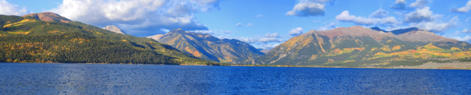
The view from Twin Lakes near Leadville this past weekend was simply stunning!
Forecast Specifics:
Monday: Sunny and mild with highs in the lower to middle 70’s for the Plains and lower 60’s in the Foothills.
Tuesday: Mostly sunny skies with some wave clouds around. Highs in the upper 70’s to lower 80’s on the Plains and upper 60’s in the Foothills.
Wednesday: Partly cloudy skies becoming mostly cloudy. Highs starting off in the middle 70’s on the Plains and middle 60’s in the Foothills. Dropping temperatures Wednesday evening and overnight well below freezing. Light snow showers could break out near or slightly before midnight.
Thursday: Cloudy with accumulating snow almost a certainty. Preliminary indication is for 1 to 4″ of snow across the Denver Metro area. These amounts will be fine-tuned in the coming days so check back. Highs in the upper 20’s to lower 30’s on the Plains and middle 20’s in the Foothills.
Friday: Mostly sunny and cool with highs in the 40’s for the Plains and 30’s in the Foothills.
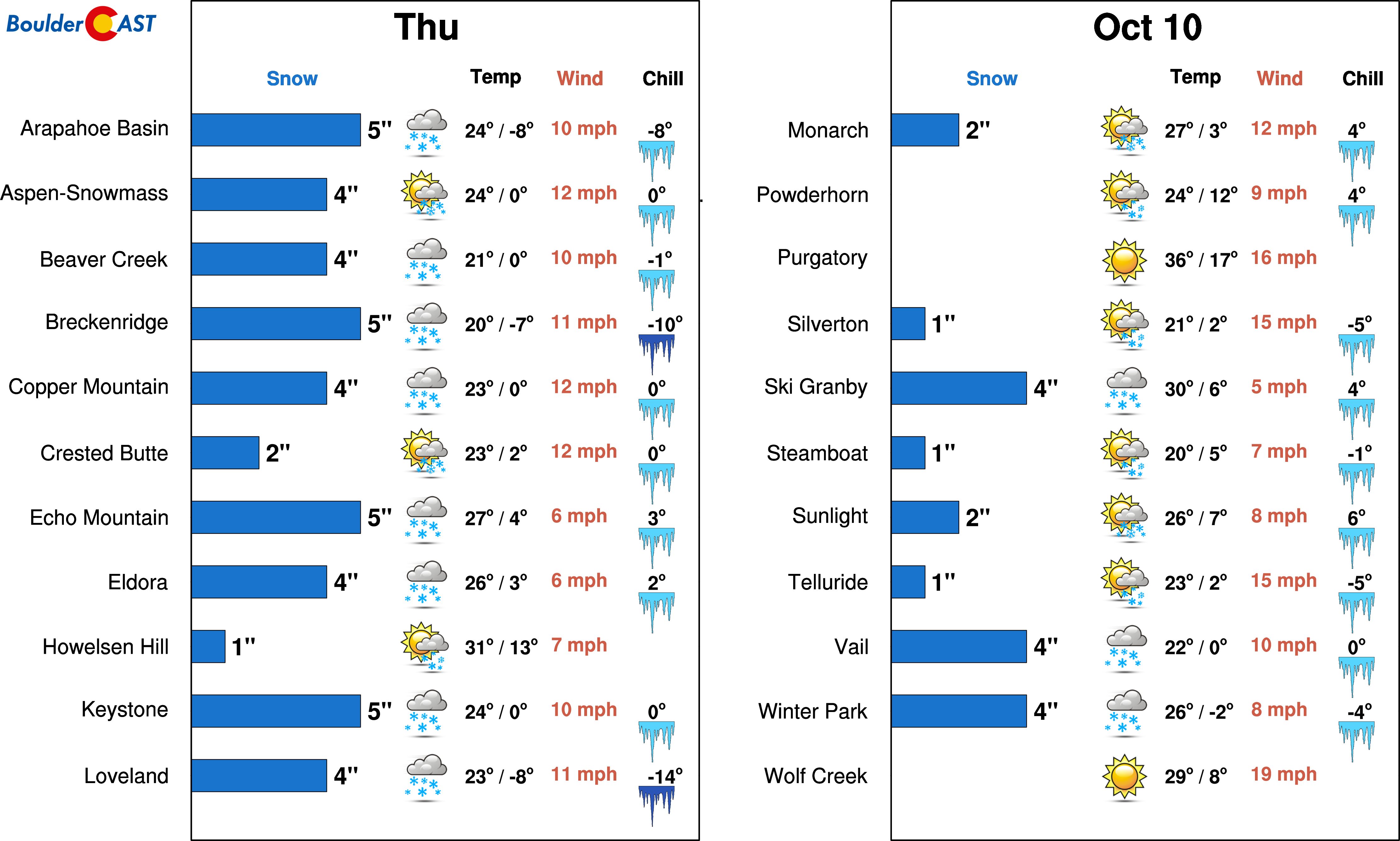
High Country: Quiet weather to start the week in the mountains with calm conditions and mild temperatures. The peaks and ski resorts, however, are likely going to see their first major taste of winter Wednesday night into Thursday night as a strong storm system takes shape late in the week. Cold weather will prevail on Friday with gradual improving conditions. Our PowderCAST ski forecast products began running last week. Here is the preliminary forecast for Thursday:
DISCLAIMER: This weekly outlook forecast is created Monday morning and covers the entire upcoming week. Accuracy will decrease as the week progresses as this post is NOT updated. To receive daily updated forecasts from our team, subscribe to BoulderCAST Premium.

.
Spread the word, share the BoulderCAST forecast!


You must be logged in to post a comment.