
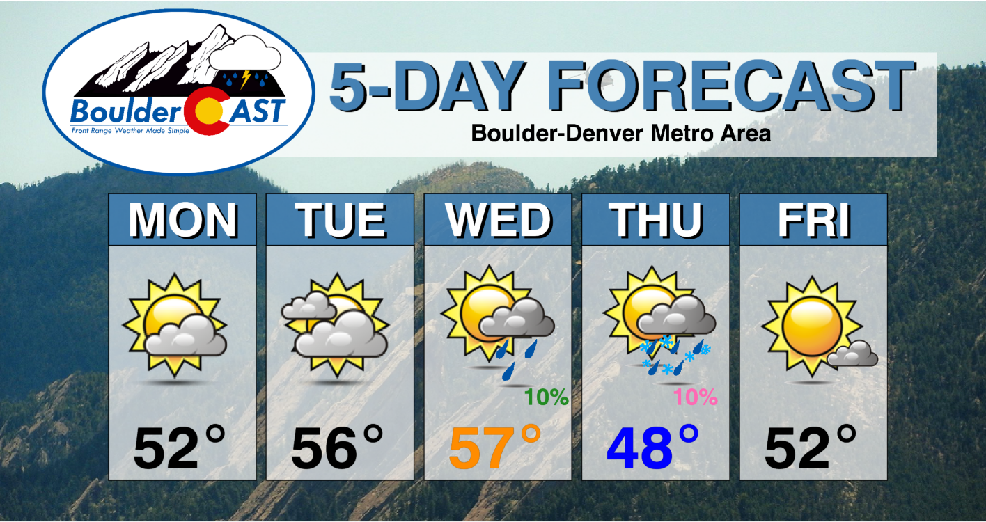
After an unseasonably warm weekend across the Front Range, this week starts and ends with seasonal to below normal temperatures. A series of cold fronts will traverse through our area as a storm system strengthens over the midsection of the country. This pattern will favor snow for the higher terrain mid to late-week, but just dry, breezy, and chilly conditions for the Plains. Denver and Boulder are both rapidly approaching record territory for the latest first snow.
This week’s highlights include:
- Seasonal to below normal temperatures the norm for the majority of the week
- Chance of light sprinkles/passing shower Wednesday, otherwise dry
- Snowfall for the higher terrain Tuesday night through Thursday
- Gusty downslope winds Wednesday and Thursday for the Plains
- The upcoming weekend looks to remain chilly to near normal, with no real chance of measurable snow in the works
DISCLAIMER: This weekly outlook forecast is created Monday morning and covers the entire upcoming week. Accuracy will decrease as the week progresses as this post is NOT updated. To receive daily updated forecasts from our team, subscribe to BoulderCAST Premium.

Quiet & seasonal to start
This past weekend was absolutely gorgeous across the entire state of Colorado, culminating on Sunday with our fourth consecutive day of 70-degree temperatures in the Metro area. Denver set a new record high temperature on Saturday reaching 80°F, indeed a rare feat for the month of November. We were a little cooler here in Boulder, but we did reach a maximum temperature of 75°F Friday, Saturday and Sunday. This is still several degrees shy of existing daily records.

The view from Boulder on Sunday 11/7/21
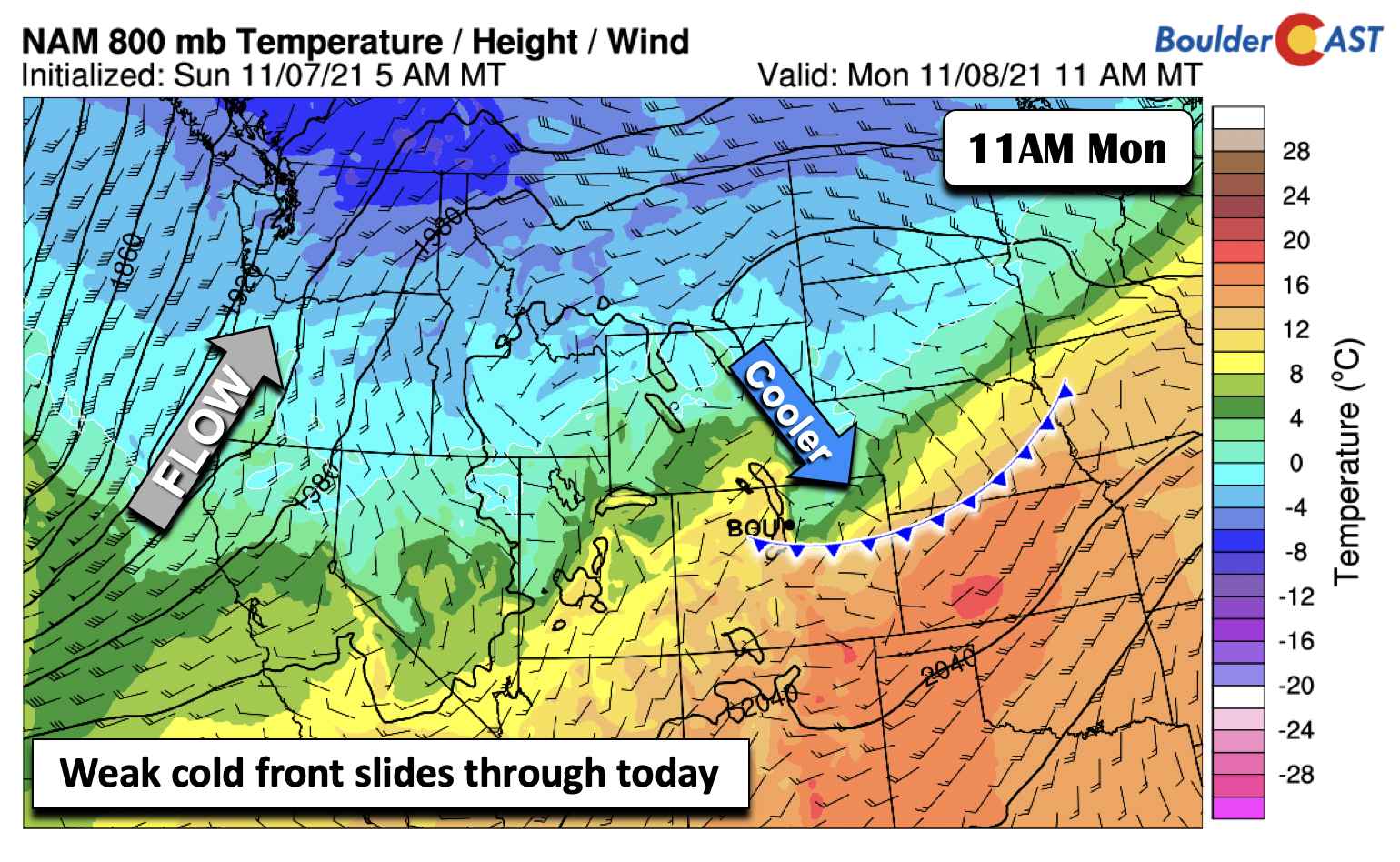
We will continue the stretch of dry and tranquil weather today but with notably cooler temperatures. As for what is going on in the mid-levels today across the country (below) there is broad high pressure over Louisiana that extends into parts of the Mid-Atlantic states. In our neck of the woods, we still remain in that southwesterly flow. However, embedded in the flow are a series of weak shortwaves. These will be tracking through the state into the evening hours, but they largely will only bring mid and high-level clouds with no precipitation.

As for highs, we’ll start off the week cooler than the weekend in the low to middle 50’s. This is thanks to a weak cold front pushing through in the morning hours on Monday (below). Temperatures will struggle to get into the 50’s by afternoon but we should ultimately get there. If you haven’t changed all your clocks back one hour still, don’t forget to do that today!
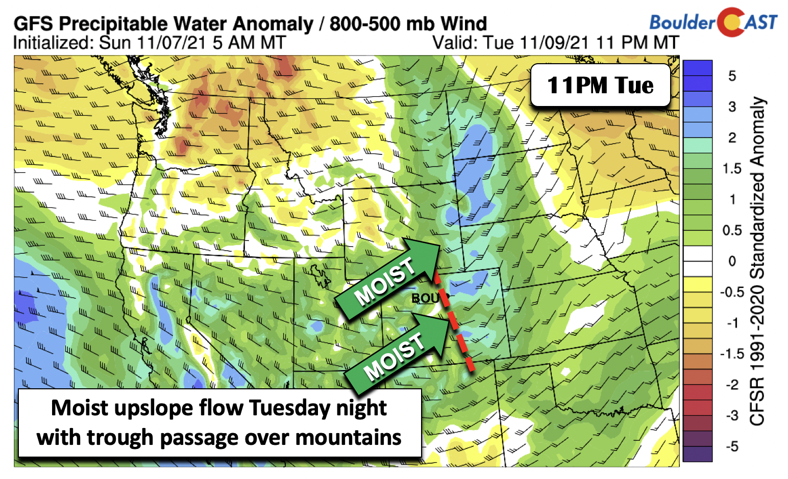
Come Tuesday a deep trough moves onshore across the Pacific Northwest. Another weak trough pushes from west to east across Colorado during the evening hours. Along with increased clouds, it will bring a chance of snow to the Mountains. As for us on the Plains, temperatures will warm up a tad from where we were Monday as the flow around the retreating cold front briefly turns out of the south and east. Highs will only rise a few degrees to the upper 50s to around 60.

Deep moist upslope will be found with this system Tuesday night across the High Country (below), with well above average precipitable water values. This will be the first of a series of systems that will impact the Mountains through Friday. We will discuss that later but snow bunnies interested in skiing may get their wish! This system on Tuesday will bring a chance of sprinkles on the Plains, but we will likely stay entirely dry as the flow off the Foothills is downslope.
Breezy & chilly to end with only slight chances of precipitation
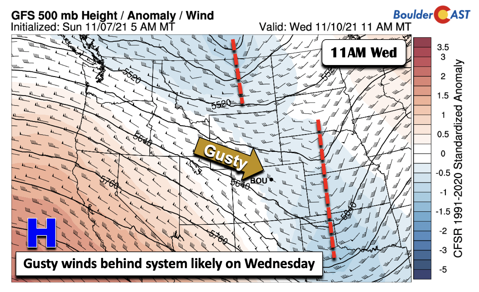
The system on Tuesday pushes into Kansas by early Wednesday (below) and deepens as it does so. In its wake, northwest winds aloft will mix down to the surface to produce the first of two periods of gusty to breezy conditions on the Plains. The second event may arrive Thursday as another trough, shown below over Montana, strengthens and moves into the Upper Midwest. The downslope flow Wednesday will keep temperatures from rising too high but also prevent them from being too cold. So, expect highs in the upper 50s.
As mentioned earlier, the trough over Montana Wednesday becomes a closed and intense circulation over the Dakotas come Thursday. While the details as to how this system evolves will need to be ironed out in the coming days, guidance has been consistent on a potent trough over the mid-section of the country on Thursday. As for how it impacts Colorado, cold air behind the trough will slip into northeast Colorado, likely clipping us in the Thursday-Friday time frame. That should lead to high temperatures falling below normal in the middle 40’s, but perhaps colder/warmer depending on the exact placement of the trough. These details are still not set in stone as the storm is still offshore as we speak!

Along with the gusty winds possible Wednesday (below left), the deep trough in the Midwest Thursday will favor a secondary chance of windy conditions across northeast Colorado (below right). Again, the placement of the trough will be key as to how far west the windy conditions get. Nevertheless, downslope flow from these two events could produce gusts in the 30 to 45 MPH range.

Colder air from that on Monday, while uncertain on timing, should arrive sometime Thursday (below). Note the much colder air aloft compared to Monday, where -16°C values are found over South Dakota! It is looking more and more like a winter pattern, but that pesky downslope flow will keep us mainly dry. The northwest flow will create another period of snow showers for the Mountains on Thursday, with a very slight chance the lower elevations could see a couple sprinkles or snowflakes again (no accumulation).

By Friday and Saturday (below), the guidance is in agreement that the system should start to shift to the east over the Great Lakes, with some weak ridging developing over the western United States. Although it is favorable for warming temperatures, we don’t want to go too far on the warm expectations. As you can see, there is still northwest flow over Colorado, which could continue to favor weak cold fronts sliding down at least for the beginning part of the weekend. As it stands now, expect a slow rise in temperatures Friday and the weekend, with highs getting back to the 50s.

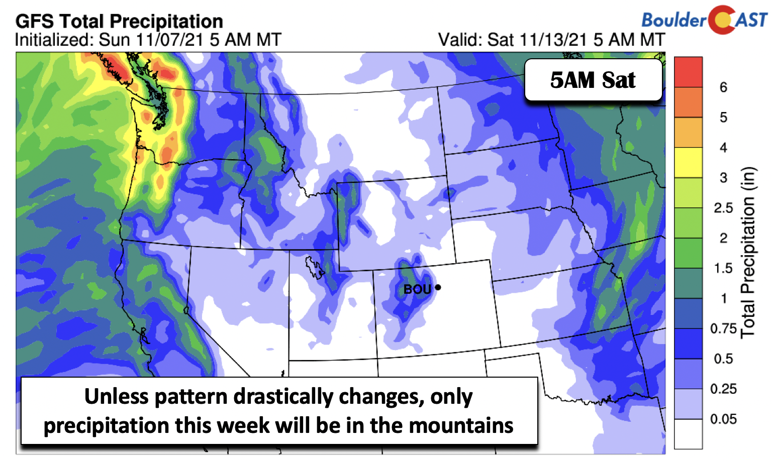
We mentioned it earlier, but a series of systems this week will produce multiple periods of snowfall for the High Country through Friday, especially over the north-central mountains (below). The GFS depicts some areas could exceed a foot of snow by the end of the week, while the Euro even indicates closer to two feet in the mountains near Steamboat.

Unless the pattern drastically changes with the evolution of the mid-level trough in the mid to late-week period, Boulder and Denver will largely stay dry. As seen in the total precipitation forecast from the GFS through Friday (below), the main precipitation threat will be found over the higher terrain with a clear “rain shadow” evident across eastern Colorado.
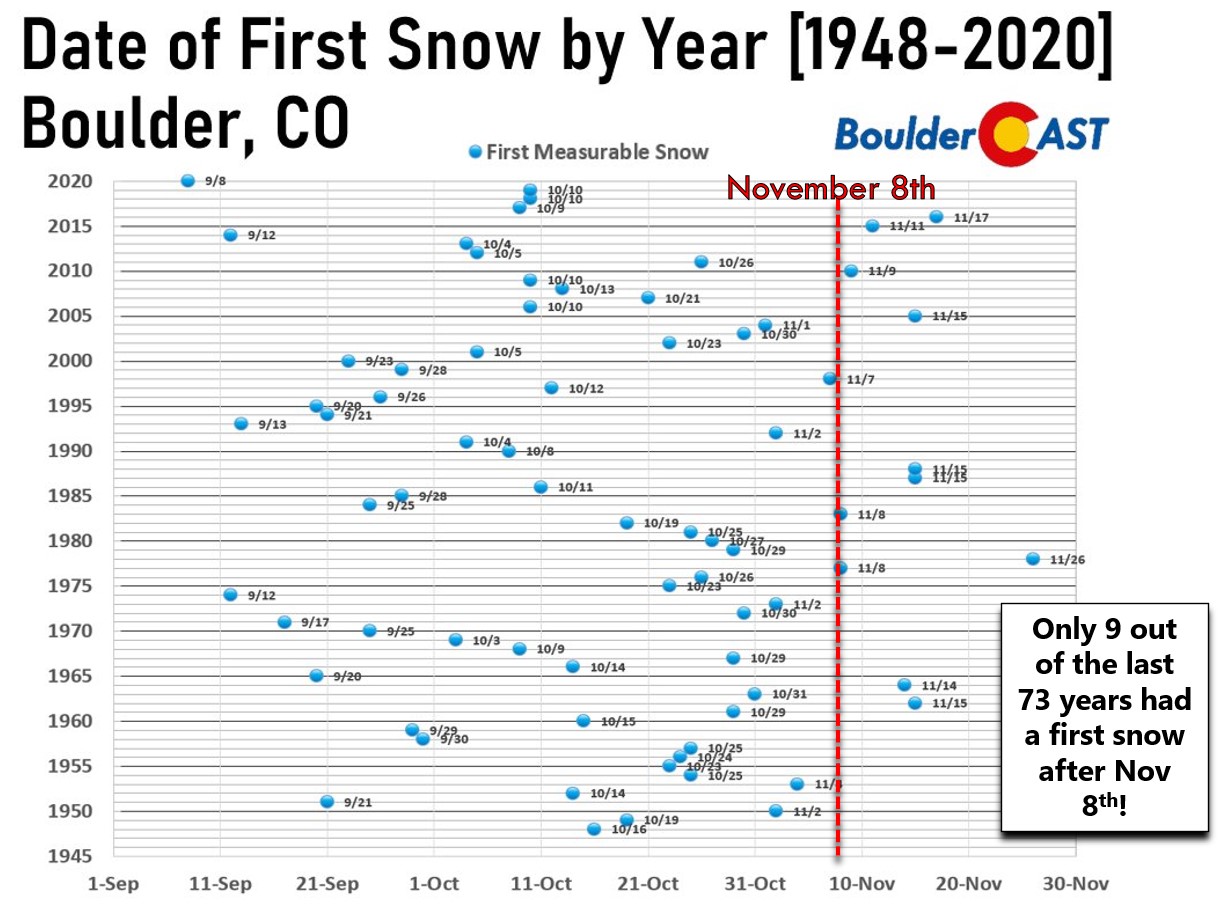
Sadly, we’re not expecting any accumulating snow this week in Boulder or Denver with the date of our first snow potentially creeping further towards record-setting territory. The latest first snow ever observed in Boulder November 26th 1978. In Denver, the latest first snow was on November 21, 1934. Given the extended forecast, it’s certainly possible we could break these records this year, but the odds are still low. It doesn’t take much to get snow this time of year so we’re not too concerned with nearly three weeks to go in Boulder. Snow can happen at any moment in the Front Range, even a mere hours after temperatures were in the 70’s or 80’s.
Finally, don’t forget that daylight savings time has now ended, not begun. Enjoy the week as we all adjust back to Mountain Standard Time!
Stay up to date with Colorado weather and get notified of our latest forecasts and storm updates:
We respect your privacy. You can unsubscribe at any time.
Forecast Specifics:
Monday: Increasing clouds. Highs cooler in the lower 50’s on the Plains and middle 40’s in the Foothills.
Tuesday: Mostly cloudy and near normal with highs in the upper 50’s to near 60 on the Plains and near 50 in the Foothills. Some light rain/snow showers are possible in the Foothills during the overnight.
Wednesday: Mostly cloudy skies becoming partly cloudy with highs in the upper 50s to near 60 on the Plains and near 50 in the Foothills. Gusty winds are possible up to 30 MPH. There’s also the slight chance of a brief sprinkle or two during the afternoon or evening.
Thursday: Colder under increasing clouds, along with breezy conditions up to 40 MPH. A few flurries or sprinkles are possible in the Denver/Boulder area, but most spots remain dry. Highs in the upper 40s on the Plains and middle 30s in the Foothills.
Friday: Chilly and dry with highs near 50 degrees on the Plains and upper 30s in the Foothills.
Mountains: A series of systems will track through the mountains from Tuesday through Friday, bringing gusty winds, snowfall, colder temperatures, and cloudy conditions. Some locations could see over a foot of snow by the end of the week, especially near Steamboat.

Help support our team of Front Range weather bloggers by joining BoulderCAST Premium. We talk Boulder and Denver weather every single day. Sign up now to get access to our daily forecast discussions each morning, complete six-day skiing and hiking forecasts powered by machine learning, first-class access to all our Colorado-centric high-resolution weather graphics, bonus storm updates and much more! Or not, we just appreciate your readership!
.
Spread the word, share the BoulderCAST forecast!
.


You must be logged in to post a comment.