A snowy forecast is in store this week as two weather systems take aim on the state. The first one approaches overnight tonight, while a second one gears up for Thanksgiving. In between these systems, the weather will remain tranquil with temperatures below average for the most part this week. Read on for our detailed forecast discussion on snow amounts and the week as a whole.
This week’s highlights include:
- Today is warmest day in the 50’s
- Two snow storms: one today and one (less certain) for Thanksgiving
- With exception of today, most of week to remain below normal
DISCLAIMER: This weekly outlook forecast is created Monday morning and covers the entire upcoming week. Accuracy will decrease as the week progresses as this post is NOT updated. To receive daily updated forecasts from our team, subscribe to BoulderCAST Premium.

Snow storm #1
It is hard to believe that 2020 is already into late November. It is even harder to believe that this week is Thanksgiving. 2021 can’t come soon enough for many of us with the ongoing pandemic spoiling much of the year. This week is going to be quite active with two storms taking aim on the region. The first one approaches overnight tonight into tomorrow morning/afternoon, while a second one potentially approaches for Thanksgiving. The first one looks stronger but we wouldn’t count out Thursday either yet given its uncertainty!
With morning sunshine, clouds will increase late Monday ahead of a deep area of low pressure moving in from the southwest later tonight. Temperatures will be much nicer than Sunday with mid to upper 50’s. We would not be surprised to see a few locations in southern Denver to reach the 60-degree mark.
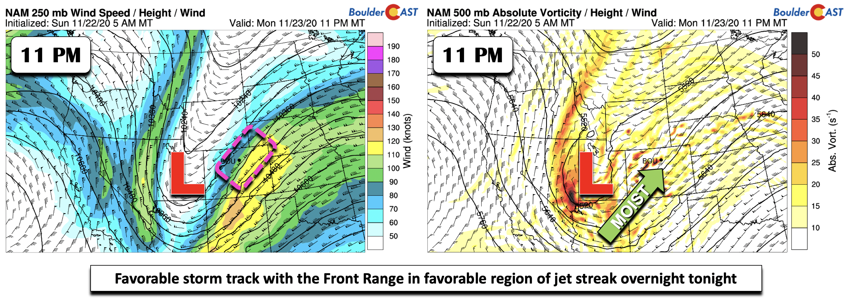
The first storm tonight/tomorrow really has that classic El Niño look to it, with a semi cut-off area of low pressure near the Four Corners (below). Tonight, the trough tracks from west to east. As it does so, it will generate good lift over our area. Part of the lift will additionally be aided by a strong 100+ MPH jet streak oriented southwest to northeast (below left). This jet streak will put the Front Range in the favorable left exit part of the jet stream for possible banded snow.
The region should be dry through a portion of the overnight, with any precipitation not beginning until after midnight.
Some of the downsides of this storm will be the marginal temperatures and short duration of upslope (roughly 6 to 8 hours). Shown below is the NAM model temperatures at 5,000 feet up (below left) and at the surface (below right) for 5AM Tuesday. Aloft, temperatures are around 4 degrees below freezing. This is just cold enough for snow. At the surface (below right), temperatures are hovering at or slightly below freezing by sunrise Tuedsay. This will mean likely a short period of rain, changing over to snow early Tuesday morning.
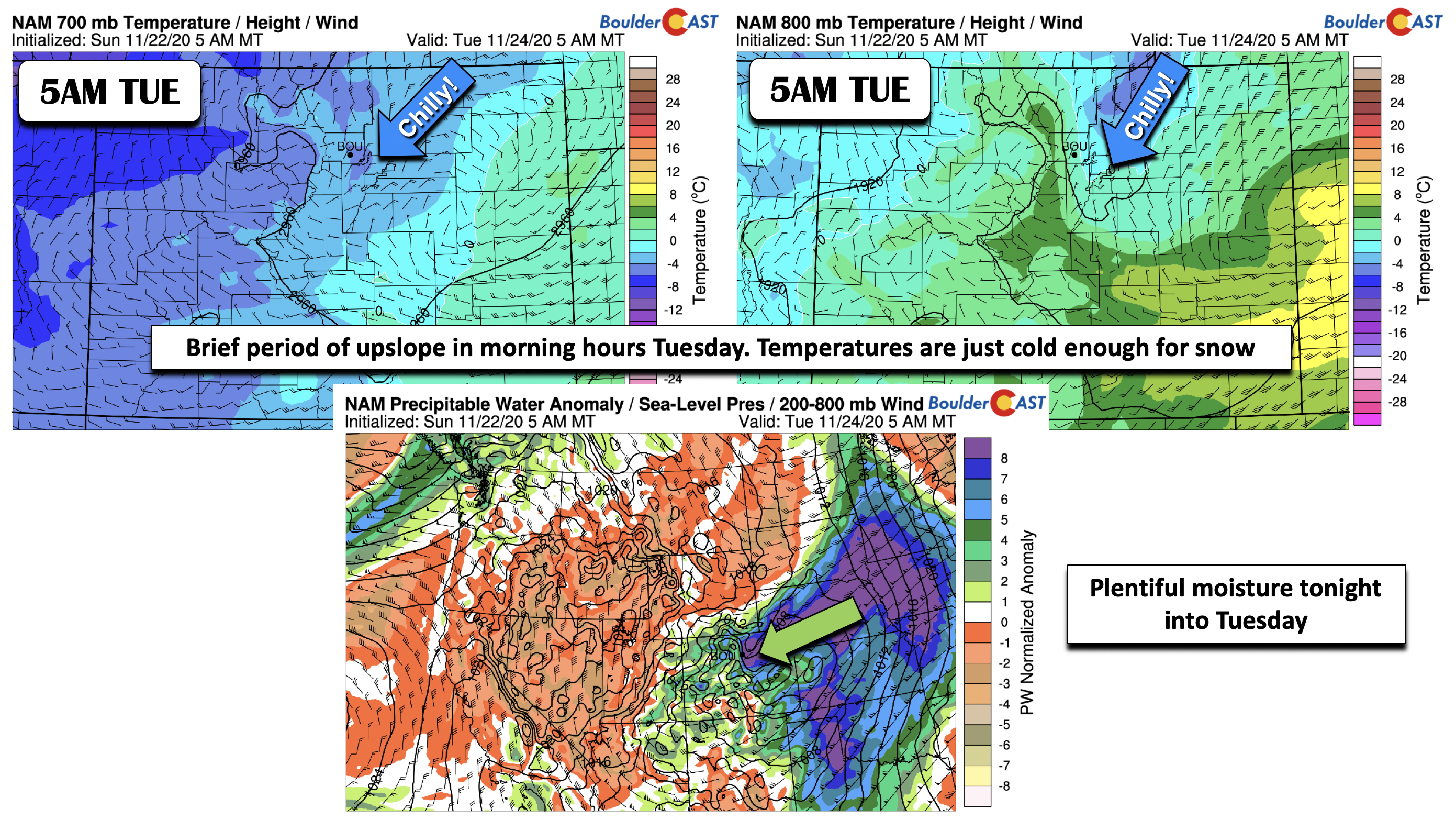
Shown also in the middle image above is that there is plentiful moisture with this storm system. The moisture is well above average for late November thanks in large part to this storm’s juicy southern track.
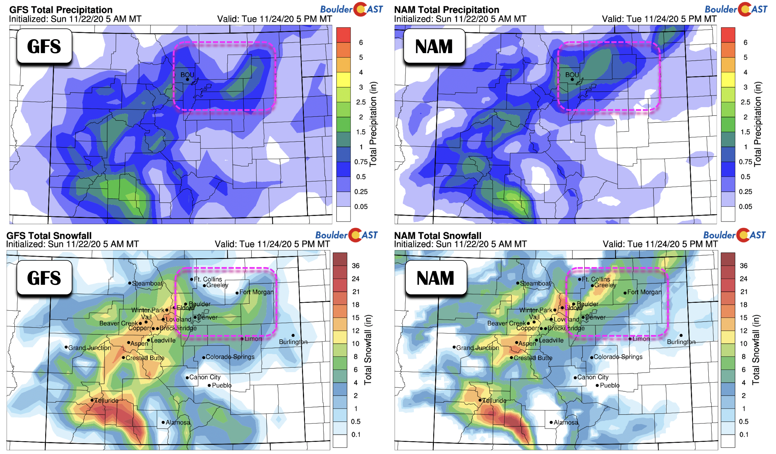
What can we expect? That is the main question. Below are the GFS/NAM model forecast total precipitation (top panels) and total snowfall from our own snow algorithm (bottom panels). The model guidance here indicates a swath of 0.5″ of precipitation, with the NAM on the higher end of up to 1″ of precipitation. Although there are differences, the models agree fairly well on 2 to 7″ of snow over the Plains, with some isolated higher amounts possibly due to banded snowfall.
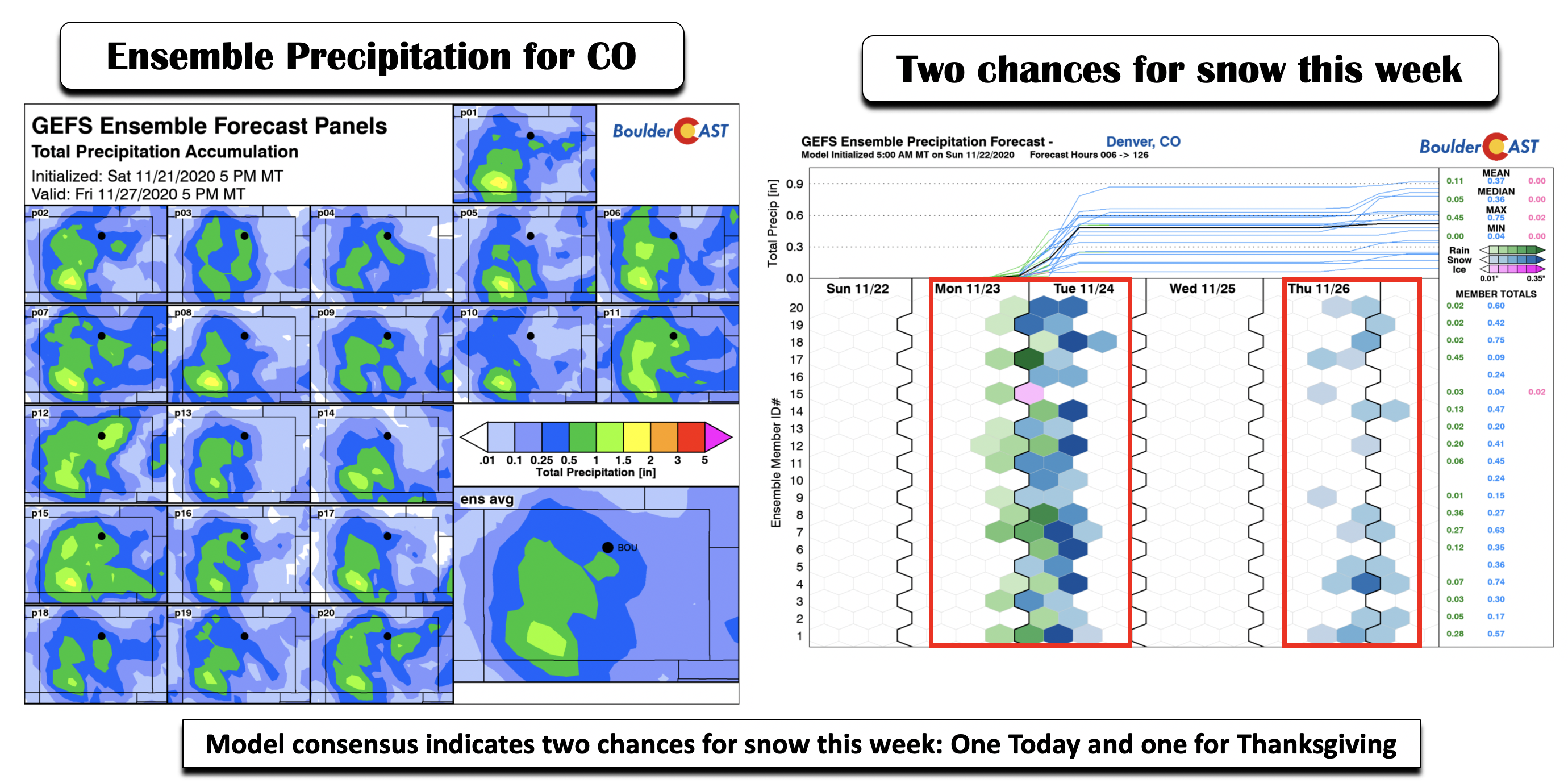
If we take a look at the ensemble forecast guidance, the ensemble mean for the region paints a quarter to one half inch of liquid precipitation (bottom left). This is consistent with the ensemble plume diagram in the bottom right, showing around 0.5″ of liquid for Boulder. Also of note, the plume diagram shows two snow events, the first one today and the second one on Thanksgiving, though the second one is largely more uncertain at this point.
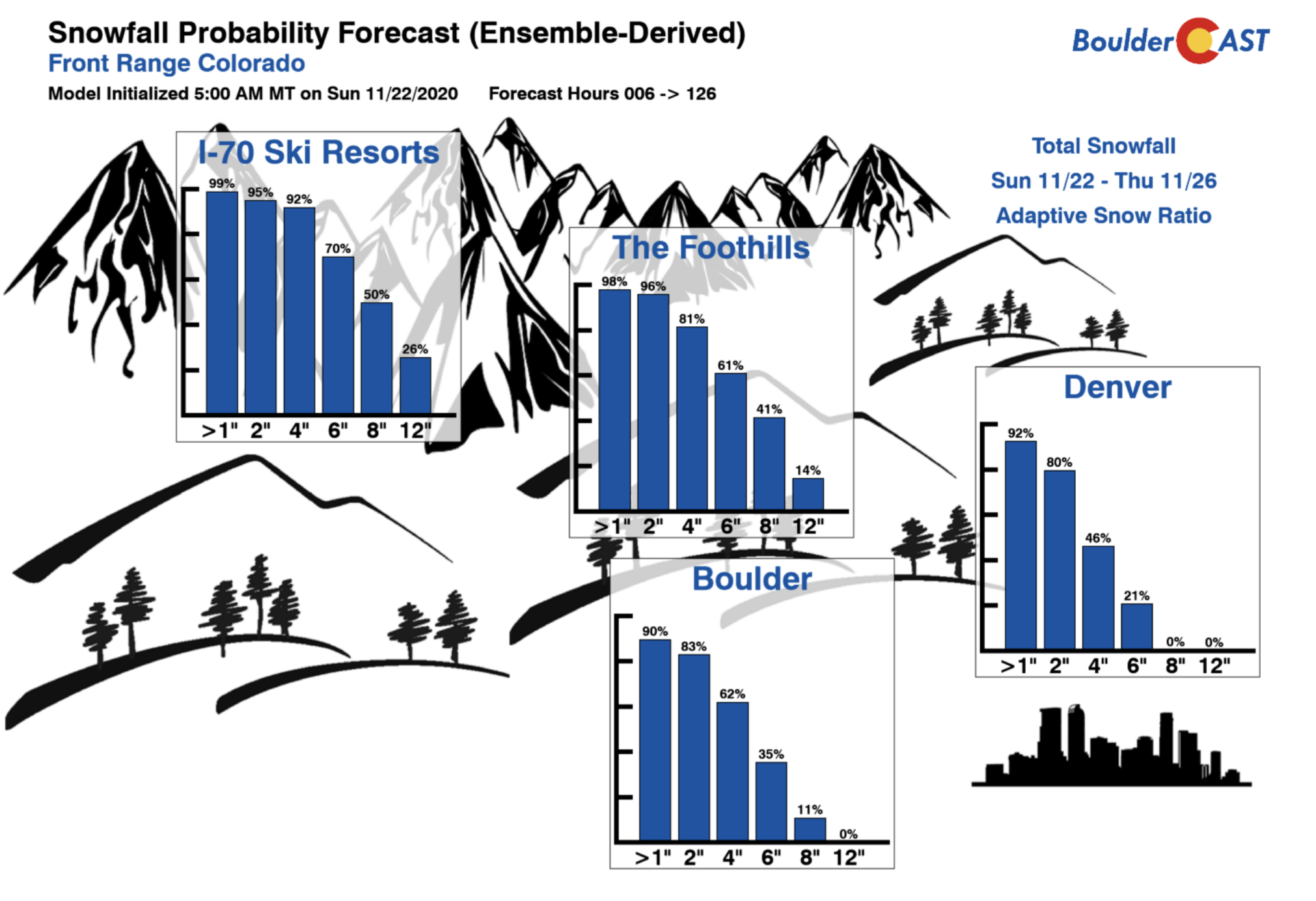
Finally, if we look at our snowfall probability forecast for the Ski resorts, Foothills, and the Boulder/Denver region, there is good probability of seeing 1-5″ of snow for the Plains and above 8″ in the mountains and Foothills.
So where does this leave us? Here are the key factors:
- Storm has good moisture, lift, and just enough cold air for snow
- Period of precipitation is short in duration, only 6-8 hours in the morning Tuesday
- Upslope is brief but lift is strong with possible jet interaction
- Good agreement for up to 0.5″ of precipitation
Given the above factors, here are our thoughts on how this first snow event will play out:
- We remain dry on Monday with clouds increasing through the evening
- Temperatures in the 50’s drop into the lower 30’s overnight
- Light rain develops after midnight, with a transition to snow early Tuesday morning
- Best period of snow will be between 3 AM and 11 AM Tuesday
- Snow tapers off late morning/early afternoon with temperatures in the upper 30’s for the rest of Tuesday
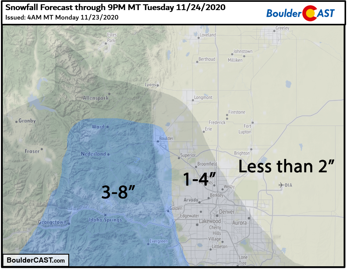
For amounts, we are forecasting 1-5″ of snow for the region. Higher amounts will be favored near Boulder and along the Foothills southward and lesser amounts to the north and east (< 2″). Possible banded snow with the jet could lead to localized higher amounts in some spots, but we’re not too concerned about this right now. Our snowfall forecast map for the event is shown below. This covers snow falling through Tuesday evening.
Snowstorm #2 on Thanksgiving?
After the first storm system, a break in the weather unfolds by midweek. Weak high pressure ridging will take over for the afternoon on Wednesday (below), with temperatures topping out in the upper 40’s. As you can see below, another system is waiting in the winds come midweek, with its location then over the Pacific Northwest. This will be something to watch for Thanksgiving.
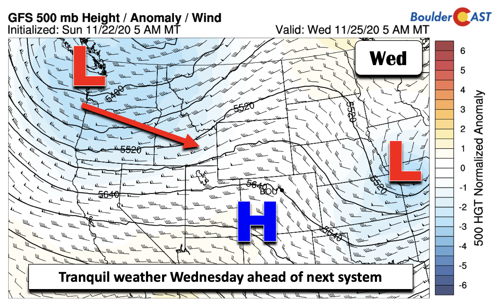
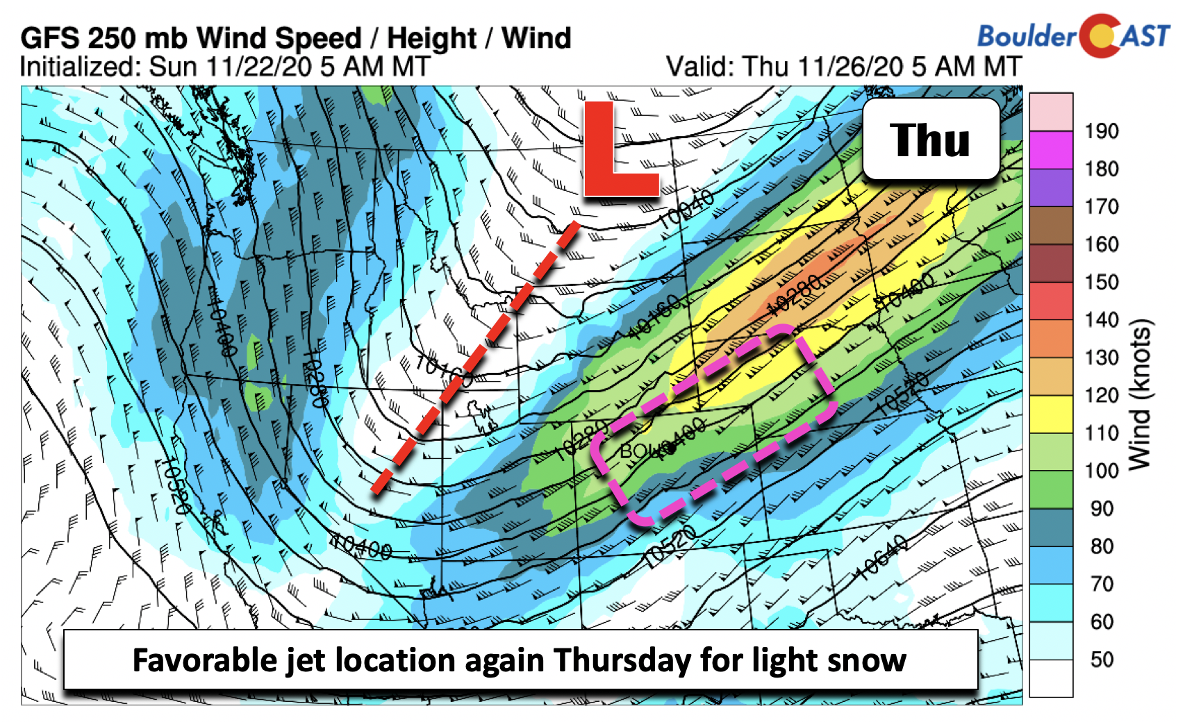
The model guidance as of right now is showing that this Thanksgiving storm will be more like what we typically would expect during La Niña, as opposed to the El Niño vibes we are getting with the first storm. It currently indicates a weak west-northwest flow at the mid and upper-levels. Along this flow, a jet streak is located southwest to northeast over the state (below). While the first storm had us in the favorable left exit part of the jet, this Thanksgiving event places us potentially in the right entrance region. This will be something to watch as banded snow typically occurs with this setup. The ensemble guidance (shown earlier) hints at the snow chance, but the details are still a little fuzzy at this stage. For now, just be aware that we could get snow once again for the holiday with temperatures in the low 40’s.
Clearing out by week’s end
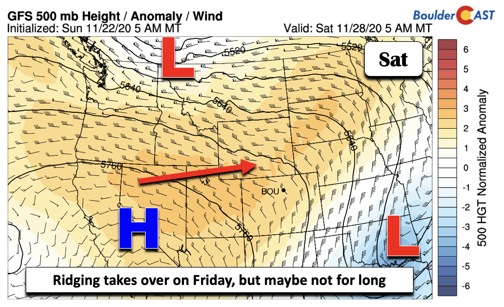
By Friday, the second potential snow event will have moved off into Kansas and the Midwest. In its wake, the forecast guidance is in good agreement that high pressure will take over for late Friday and Saturday. However, it will not be long-lived, as the jet stream continues to remain active by the late upcoming holiday weekend. Another cold front is poised to drop down sometime late Saturday or early Sunday.
Have a safe, pleasant, and enjoyable Thanksgiving – and keep your fingers crossed for snow!
Forecast Specifics:
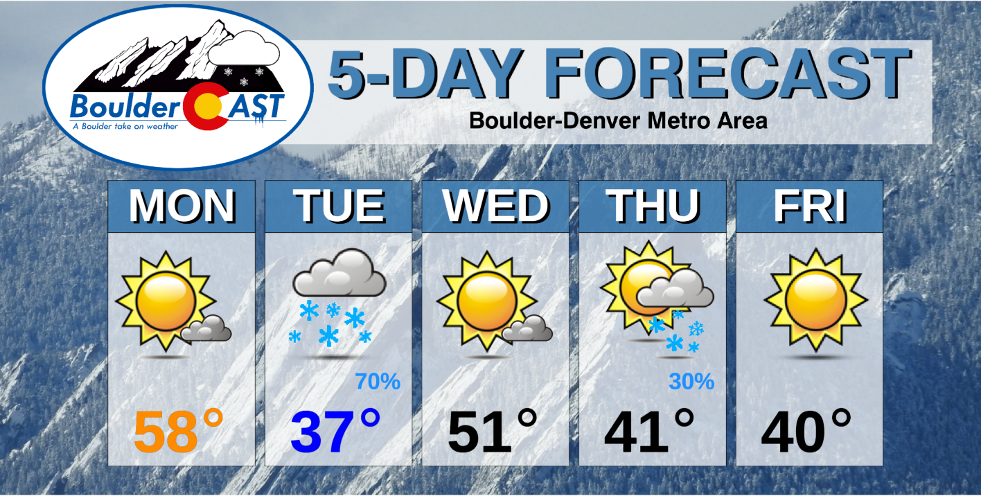
Monday: Sunny skies becoming mostly cloudy through the evening with highs in the mid to upper 50’s on the Plains and middle 40’s in the Foothills. Light rain/snow develop overnight tonight.
Tuesday: Snow in the morning, then cloudy in the afternoon. Snow totals of 1-4″ across the Front Range and 3-8″ in the Foothills. Highs in the upper 30’s for the Plains and upper 20’s in the Foothills.
Wednesday: Mostly sunny and warmer with highs near 50 degrees for the Plains and middle 30’s in the Foothills.
Thursday: Partly to mostly cloudy with a chance of light snow. Some accumulations possible. Highs near the lower 40’s on the Plains and lower 30’s in the Foothills.
Friday: Morning clouds, then mostly sunny with highs in the lower 40’s for the Plains and lower 30’s in the Foothills.
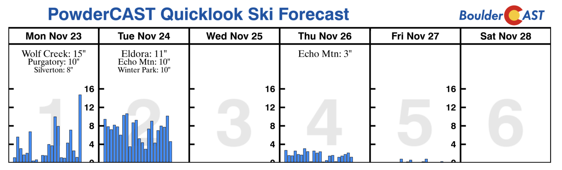
Mountains: It will be a snowy week for the High Country. Several inches of snow are expected today and tomorrow. Another round is expected late in the week Thursday into Friday. If you are going skiing for the holiday, you should be able to find some relatively fresh powder! Find daily updated forecasts for all the Colorado ski resorts over at our PowderCAST page.
Help support our team of Front Range weather bloggers by joining BoulderCAST Premium. We talk Boulder and Denver weather every single day. Sign up now to get access to our daily forecast discussions each morning, complete six-day skiing and hiking forecasts powered by machine learning, first-class access to all our Colorado-centric high-resolution weather graphics, bonus storm updates and much more! Or not, we just appreciate your readership!
.
Spread the word, share the BoulderCAST forecast!
.


You must be logged in to post a comment.