Elevated fire conditions will be in place nearly every day this week, though the most dangerous conditions will be Monday, Wednesday, and Thursday with strong winds and warm/dry conditions across the Front Range. Above normal temperatures will be around throughout the week, with potential record highs shaping up for Wednesday. The week remains dry overall, although there will be some light Mountain snow at the beginning and latter part of the week — certainly not enough to please the skiers. Read on for our full weekly outlook.
This week’s highlights include:
- Red Flag conditions on Monday with strong winds and warm/dry conditions
- Potential Denver Cyclone Tuesday with reduced fire danger and declining air quality
- Near-record highs Wednesday in the upper 80s with critical fire conditions
- Highs staying above normal through the rest of the week with a few late-week systems and continued fire danger

DISCLAIMER: This weekly outlook forecast is created Monday morning and covers the entire upcoming week. Accuracy will decrease as the week progresses as this post is NOT updated. To receive daily updated forecasts from our team, among many other perks, subscribe to BoulderCAST Premium.

Elevated Fire Risk to start the week
Every single day this week will run the risk of fire danger across the Front Range. The primary days for fire concerns will be Monday, Wednesday, and Thursday, although we can’t rule out Tuesday or Friday as well for near-critical fire conditions either. On Monday, a strong upper-level jet streak will be rather elongated, stretching from west of California, eastward into Nevada, Utah, Colorado and northeast into the Dakotas. The jet is nearly perpendicular to the north-south oriented mountain ranges in the state, a prime setup for strong downslope winds.
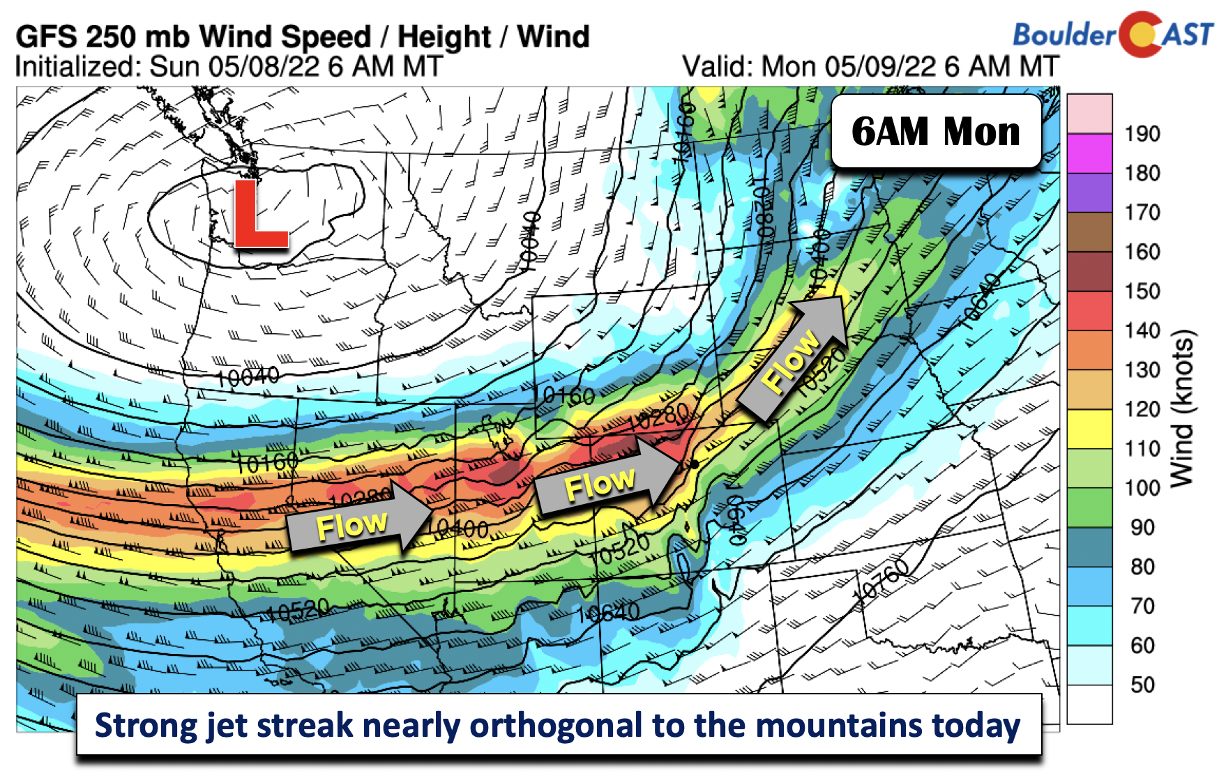
Highs will be in the mid to upper 70s over the Denver Metro. That, along with dry air in place and the strong winds, will lead to Red Flag conditions Monday over most of the area. The strongest wind gusts will be found during the morning hours, at times peaking upwards of 30-50 mph in the Foothills. As we go into the afternoon, the jet will reorient itself, such that the winds will decrease slightly but remain elevated in the 20 to 35 mph range for the Boulder-Denver area.

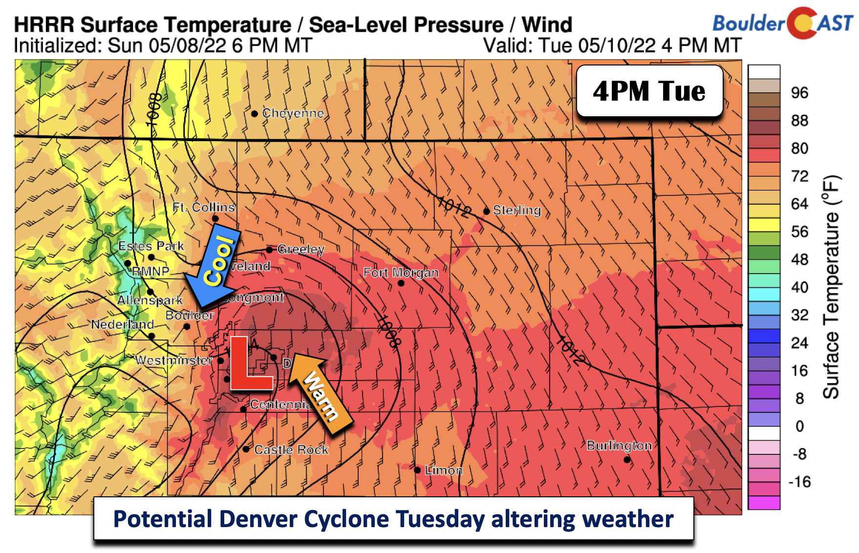
Weak cool front forces development of Denver Cyclone Tuesday
A weak cold front will slide down from Wyoming and Nebraska late tonight into early Tuesday. It will settle into southern Colorado by 6 AM Tuesday. The warmth will thus get shunted to the south and east. The “cool” weather will more or less be short-lived.
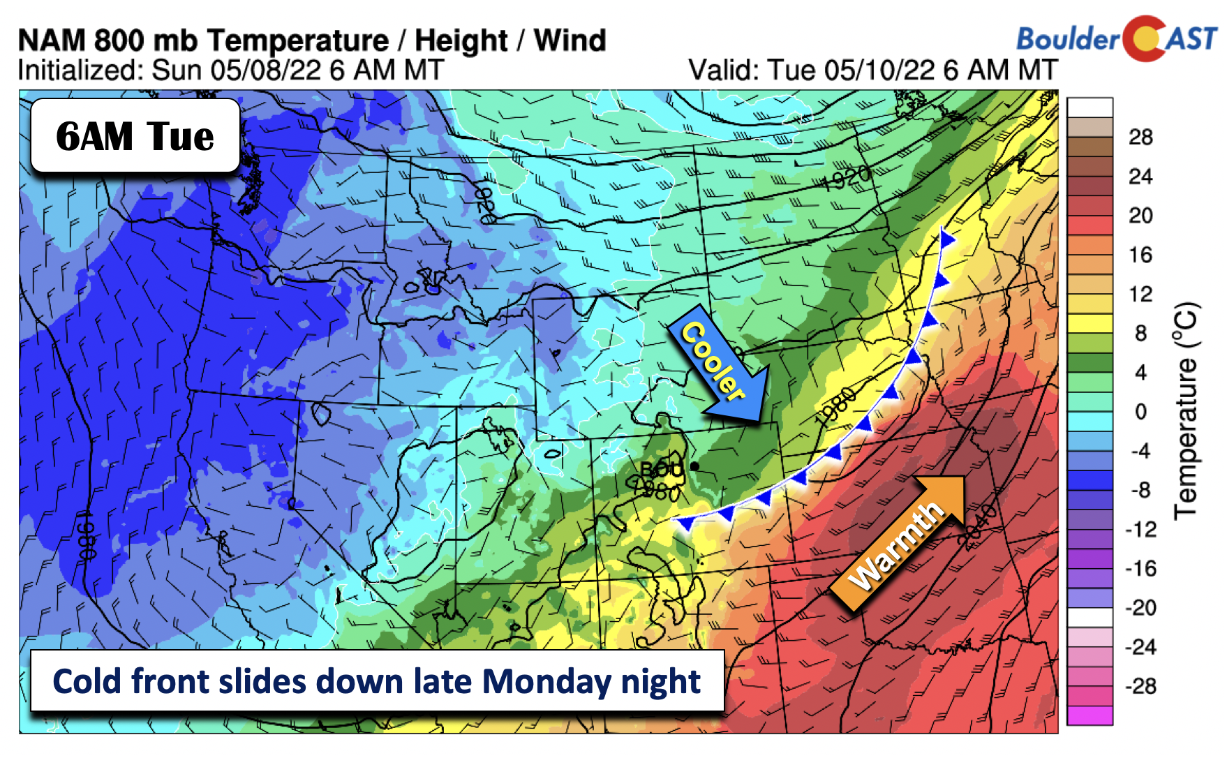
With time, the front will weaken and start to inch northward as a warm front, though not fully move through the state until Wednesday. As the front lifts north, much of the global and high-resolution guidance are indicating that a Denver Cyclone will develop as a result of the pressure difference along the boundary. If this does come to fruition, Tuesday’s highs will see a large spread, from the middle 70s in Boulder to the lower 80s in Denver. In addition, winds will shift from the north in Boulder to southerly in Denver. Our confidence in this is about 50%. The cyclone would favor a somewhat elevated fire risk in Denver with warm/dry conditions and some breezy south winds, along with reduced air quality in the northwestern parts of Denver and Boulder from upslope.
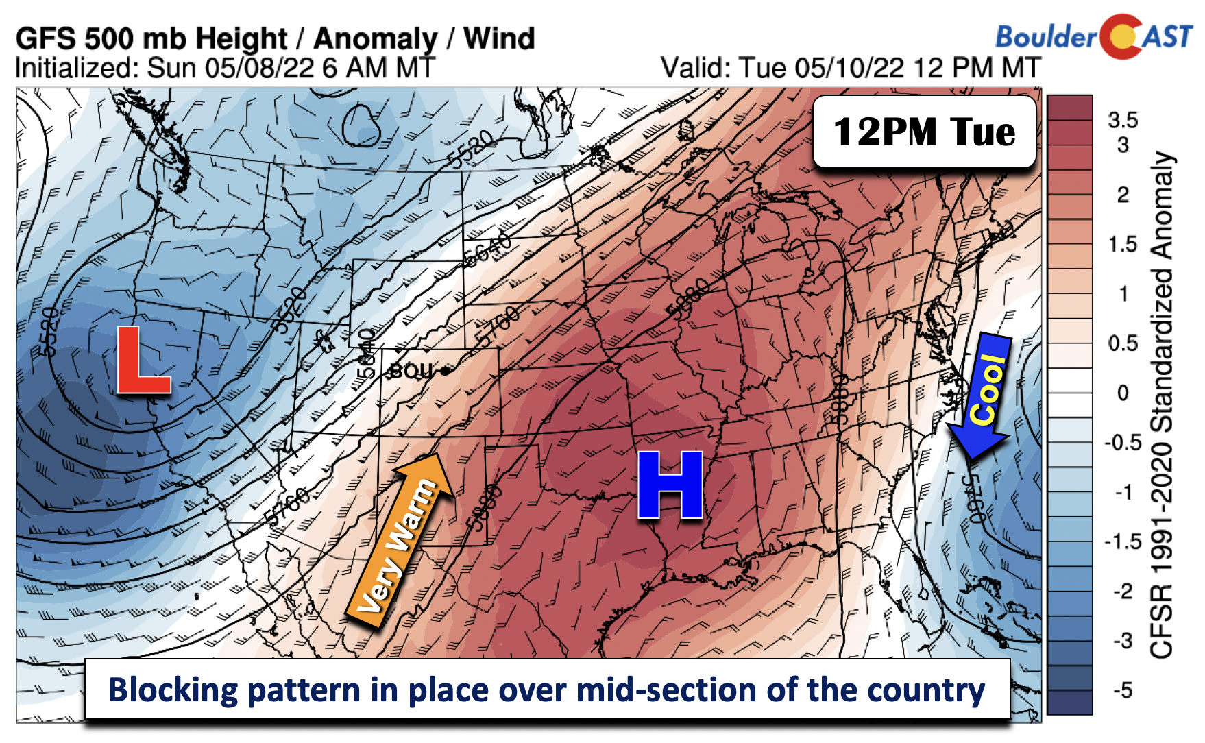
On a larger scale across the nation, a blocking pattern will be in place through much of the week. On Tuesday, a large and anomalous area of high pressure will be centered over the Mid-Mississippi Valley, while a trough will be centered out in California. Another trough will be over the southwest Atlantic, just east of the Carolinas. The result will be very hot temperatures in the Midwest and Great Plains/western U.S. through mid to late week, while below normal temperatures across the far west and far east.
Near Record Highs Wednesday with fire concerns
We will see the very hot weather come Wednesday, with near-record highs up and down the Front Range. By then, the mid-level ridge will largely remain unchanged, shifting ever so slightly to the north over eastern Missouri, while the trough out west dives into southern California. The eastern trough retrogrades and settles east of Florida. Highs will be in the 90s over the Midwest.

The figure below may show the pattern more markedly, with well above average temperature anomalies over the mid-section of the country, from Colorado all the way into the Ohio Valley.

As for us on Wednesday, the frontal boundary from Tuesday will lift fully north into Nebraska/South Dakota as a warm front by midday. Behind it, a potent south-southwesterly flow will pump in very dry and hot weather from New Mexico. Highs should soar into the upper 80s, putting record highs in jeopardy of being broken. The record in Boulder is 88°F set in 1963. It will also be breezy with wind gusts likely over 30 mph, putting the risk of Red Flag conditions again in place. There is the slight chance that the setup Wednesday night/early Thursday could favor severe thunderstorms along the Colorado/Kansas border with the trough moving through. For now, our area should be dry with the moisture well removed from the Denver area.

Remaining mild with fire danger to end the week
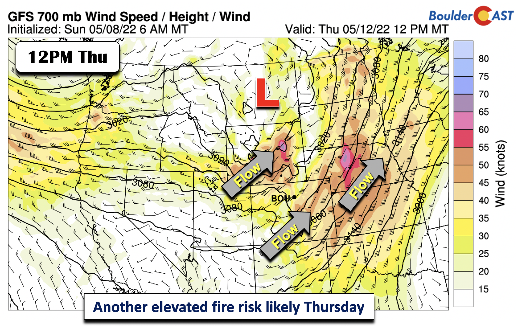
The trough over southern California on Wednesday will finally move northeast into Montana/Wyoming by early Thursday, as the ridge weakens somewhat and shifts south and east. The anomalous heat will also exit. As the system takes its northeastward track, west-southwest winds will strengthen behind the system early Thursday. Sorry to say, but this will likely favor another afternoon of high fire danger, with wind gusts likely in the 30 to 40 mph range. Highs should be remain above average but only in the 70s as opposed to the 80s on Wednesday.
We’ll end the week in the 70s again on Friday, although it is possible highs will again approach 80 in spots. A few models are hinting at another cold front late Friday to early Saturday as troughing develops from the Pacific Northwest and northern Rockies. If this happens, expect a chance of snow in the northwest part of our state, followed by a trend to lower 70s for the weekend. Unfortunately, it looks dry all week.

The week ahead will be a dangerous one for our entire state with warm and dry air coincident with strong winds and widespread drought. We must remain vigilant and do our best to prevent any new fire ignitions!
Forecast Specifics:
Monday: Red flag conditions with gusty winds over 30 mph, especially south of Denver, and highs in the mid to upper 70s on the Plains and middle 60s in the Foothills.
Tuesday: Mostly sunny and above average again with middle 70s in Boulder to the lower 80s in Denver and middle 60s in the Foothills. Elevated fire concerns are possible in Denver and down across southeast Colorado.
Wednesday: Near-record heat and breezy with gusts over 30 mph possible creating dangerous fire conditions again. Highs in the upper 80s on the Plains and middle 70s in the Foothills.
Thursday: Warm and breezy with fire danger concerns once again. Highs in the mid to upper 70s on the Plains and upper 60s in the Foothills.
Friday: Sunny and warm with mid to upper 70s to near 80 degrees on the Plains and upper 60s in the Foothills. Near-critical fire conditions may once again be possible, but winds may be somewhat less intense.
Mountains: Rain/snow is possible over the north-central and northwest mountains on Monday but minor accumulations. Elevated fire danger will exist elsewhere with high winds and warm/dry conditions. Dry weather takes over Tuesday and Wednesday, although breezy conditions will continue Wednesday and Thursday from the south and southwest. Light snow may be possible late Friday and Saturday with a system encroaching on the region, but it doesn’t look like much at the moment.
Help support our team of Front Range weather bloggers by joining BoulderCAST Premium. We talk Boulder and Denver weather every single day. Sign up now to get access to our daily forecast discussions each morning, complete six-day skiing and hiking forecasts powered by machine learning, first-class access to all our Colorado-centric high-resolution weather graphics, bonus storm updates and much more! Or not, we just appreciate your readership!
Spread the word, share the BoulderCAST forecast!


You must be logged in to post a comment.