Mother Nature will continue to pummel the western United States with storm systems this week, including plenty of activity here in the Front Range. Monday will provide the most substantial severe weather outbreak in Colorado so far in 2024, but fortunately that will go down east of the Denver Metro area. Another system will bring a good chance of widespread rain for us Tuesday alongside chilly temperatures. The rest of the week into the weekend will stay somewhat active with daily chances for showers and thunderstorms. Read on for all the details.
This week’s highlights include:
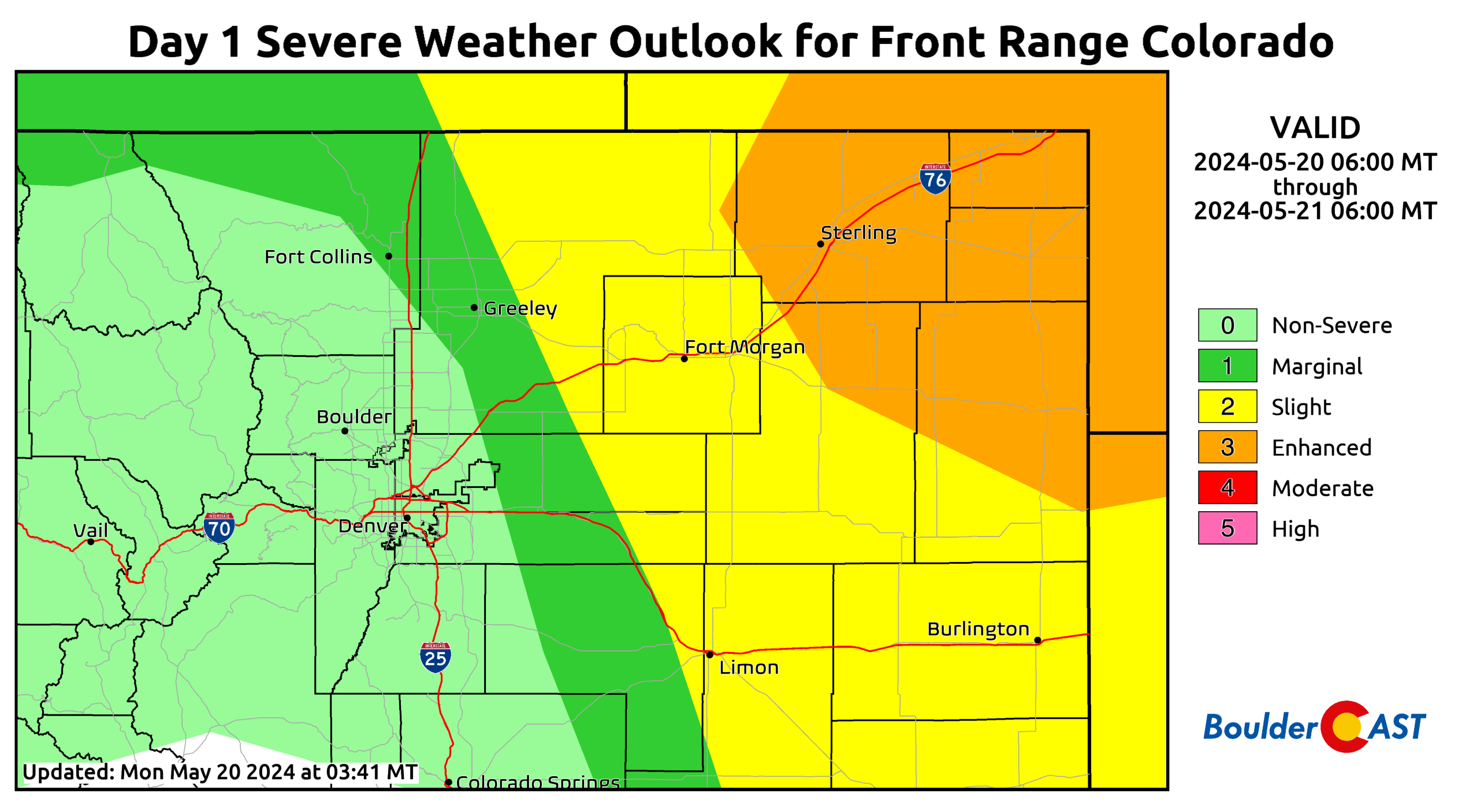
- Severe Weather Outbreak on Monday: Conditions east of the Denver Metro area are favorable for severe storms, including huge hail, strong winds (70 MPH+), and a few tornadoes.
The Boulder and Denver area is not expected to see severe storms due to a lack of moisture and instability. - Rain on Tuesday: The main trough axis from the northwest will bring widespread rain to the Front Range producing a broad-brush of 0.2 to 0.5″ of rainfall in the Metro area
- Low Chance of Frost Wednesday Morning: Clearing skies and a chilly airmass may produce areas of spotty frost Wednesday morning, though the chance is rather low.
- Lingering Storms Mid to Late Week: Weak troughing will persist over the northern Rockies leading to daily chances of late-day showers and storms Wednesday, Thursday and Friday (and into the weekend)
DISCLAIMER: This weekly outlook forecast is created Monday morning and covers the entire upcoming week. Accuracy will decrease as the week progresses as this post is NOT updated. To receive daily updated forecasts from our team, among many other perks, subscribe to BoulderCAST Premium.
Daily Forecast Updates
Get our daily forecast discussion every morning delivered to your inbox.
All Our Model Data
Access to all our Colorado-centric high-resolution weather model graphics. Seriously — every one!
Ski & Hiking Forecasts
6-day forecasts for all the Colorado ski resorts, plus more than 120 hiking trails, including every 14er.
Smoke Forecasts
Wildfire smoke concentration predictions up to 72 hours into the future.
Exclusive Content
Weekend outlooks every Thursday, bonus storm updates, historical data and much more!
No Advertisements
Enjoy ad-free viewing on the entire site.
Severe outbreak east of the Metro area Monday
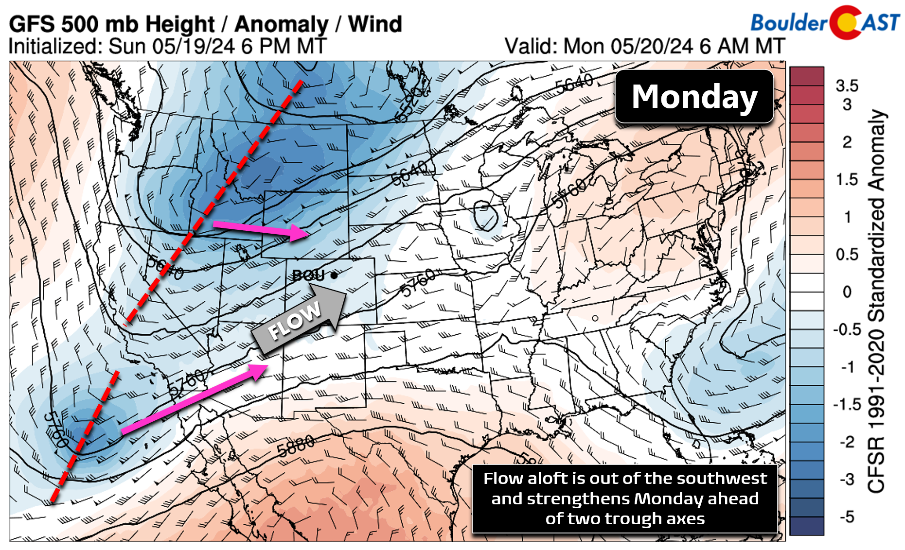
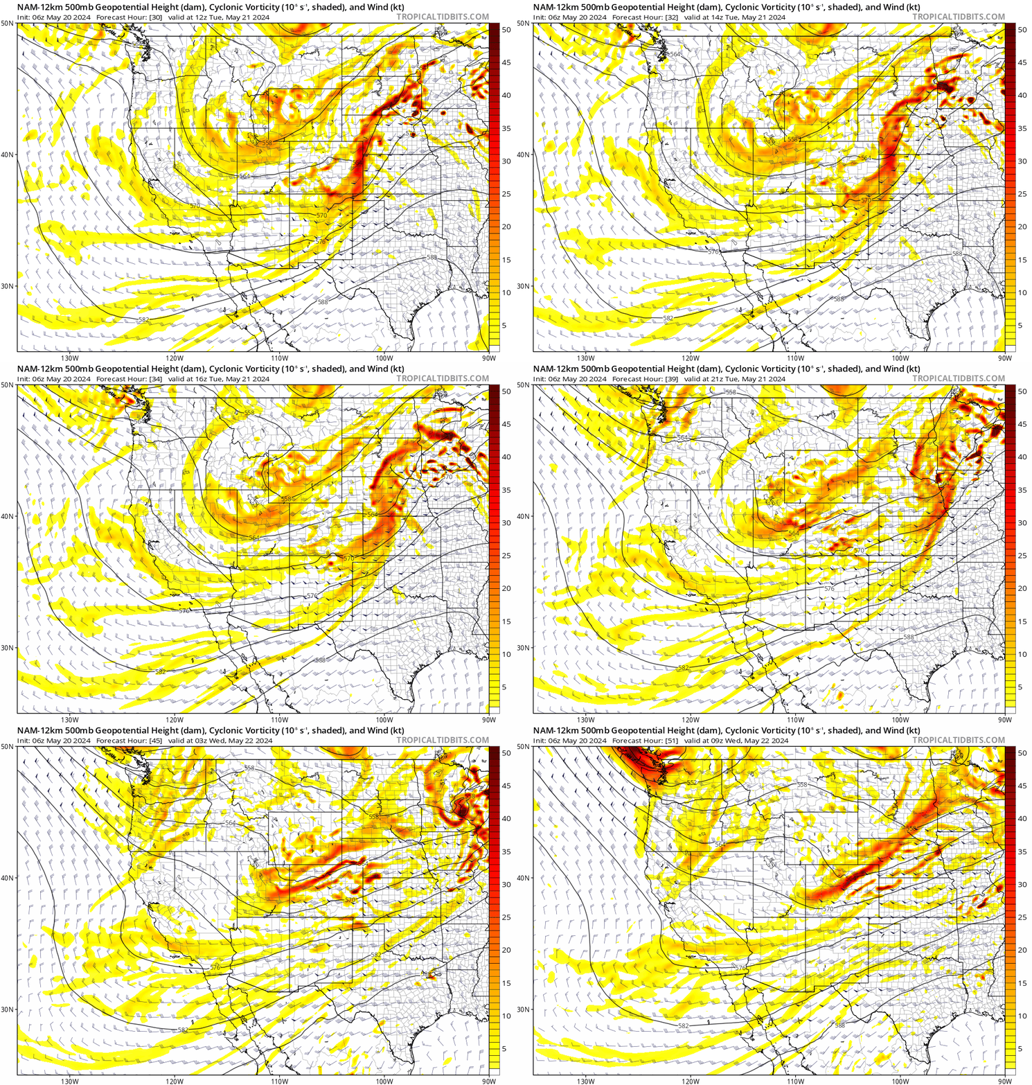
We begin the week with the most pronounced threat of severe weather yet in 2024 for Colorado! However, the action Monday afternoon and evening will be well east of the Denver Metro area where conditions are projected to be much more favorable for severe storms to pop. Broadly speaking, southwest flow will be present aloft over Colorado as two trough axes approach from the southwest and northwest today. At the same time, a lee surface low pressure will develop across northeast Colorado, leading to low-level easterly flow. This will set the stage for moisture to get drawn westward into Colorado from Kansas and Nebraska, and will also create strong bulk shear to support severe thunderstorms.
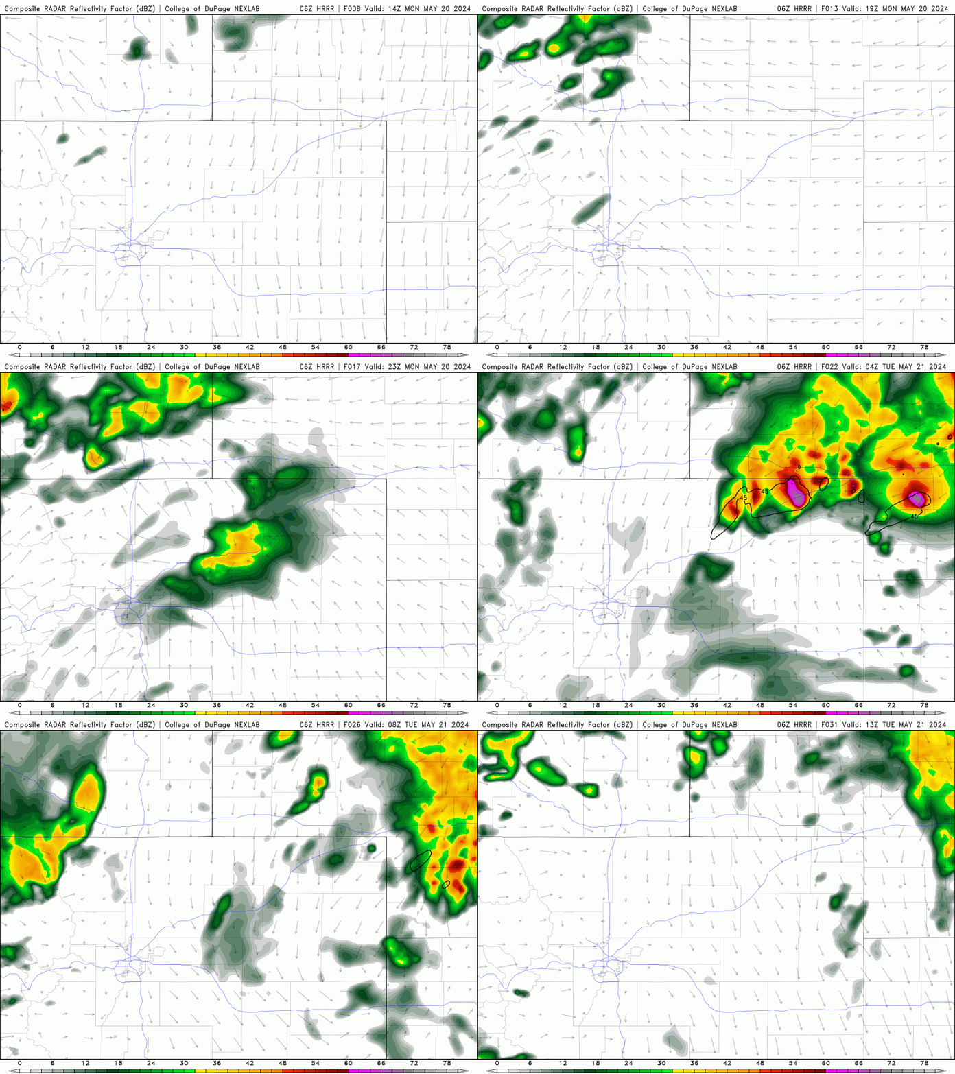
Short-range models show a few weak and gusty thundershowers developing over the Metro area Monday afternoon/evening, but most of the action will be further east where storms will explode beyond severe thresholds becoming capable of huge hail (2″+ diameter), 70 MPH winds, and a few tornadoes.
The area at greatest risk for severe storms Monday is out near the far corner of Colorado close to Nebraska where the Storm Prediction Center has highlighted Enhanced Risk. The immediate Boulder and Denver area is not expected to see any severe storms on Monday as moisture (and thus instability) is lacking over our neck of the woods.
Outside of the developing rain chance later in the day, Monday morning will at least be nice with a mix of clouds and sunshine. Skies become overcast by afternoon with rain chances and a few rumbles of thunder on the increase as well. High temperatures Monday will be in the middle 70s. Some storms may linger into the overnight period, but again that will mainly be north and east of Denver.
A better chance of rain on Tuesday
The main trough axis from the northwest will slowly rake across Colorado on Tuesday bringing the best chance of rain for the week to our area. The core of this trough axis will pass along the Colorado-Wyoming border with the best lift for rainfall occurring in the late-day period Tuesday. Lingering easterly flow behind Monday’s trough will help to increase available moisture in the Front Range on Tuesday, as well as provide a weak upslope component much of the day. This will result in developing overcast skies, cool temperatures and numerous to widespread rain showers later in the day.
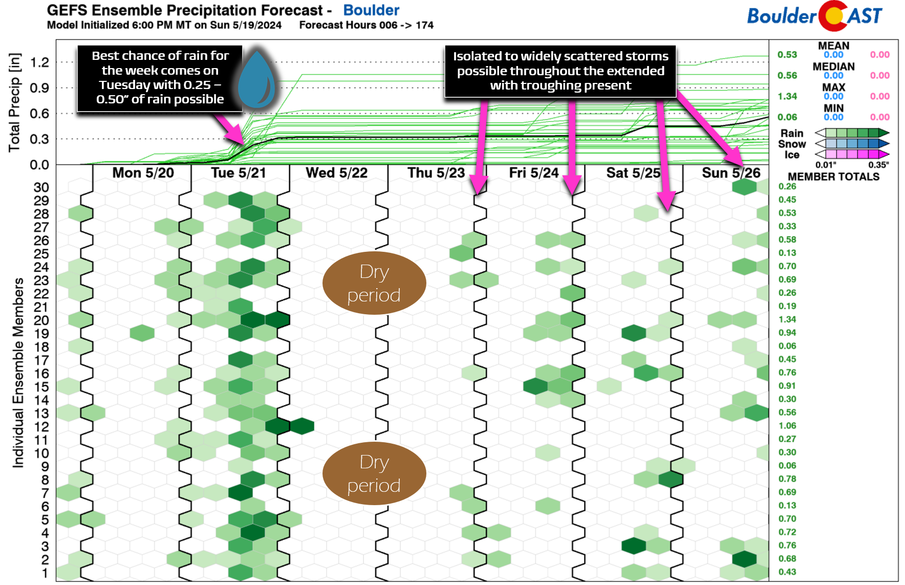
Ensemble guidance paints a soggy picture for our area on late Tuesday with anywhere from 0.20 to 0.50″ of rainfall expected in Boulder and Denver.
While not a huge amount, especially considering that May is our wettest month of the year, Tuesday is a strong candidate to be our most substantial bout of rain since the super-soaker storm about four weeks ago in late April. Rain will fizzle out and head east late Tuesday evening. High temperatures on Tuesday will struggle to reach 60 degrees across the lower elevations — well below normal for late May.
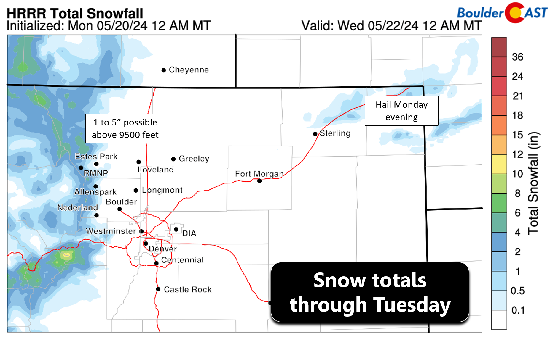
Speaking of chilly conditions, temperatures will be cold enough for snow with this system, but only above about 9500 feet. Mountain peaks along the Continental Divide, including in Rocky Mountain National Park, can expect to see a dusting up to 5″ inches of new snow.
One thing to watch this week is the potential for frost across portions of northeast Colorado late Tuesday night into Wednesday morning as skies clear and the chilly airmass remains entrenched over the area. Most model guidance is not getting cold enough for frost thanks in large part to moisture from Tuesday’s rains, but some models do want to bring temperatures down into the middle 30s which could support spotty frost in outlying portions of the Metro area. The risk for frost is fairly low, but keep this on your radar if you have sensitive plants under your care!
Spotty storms linger mid to late week
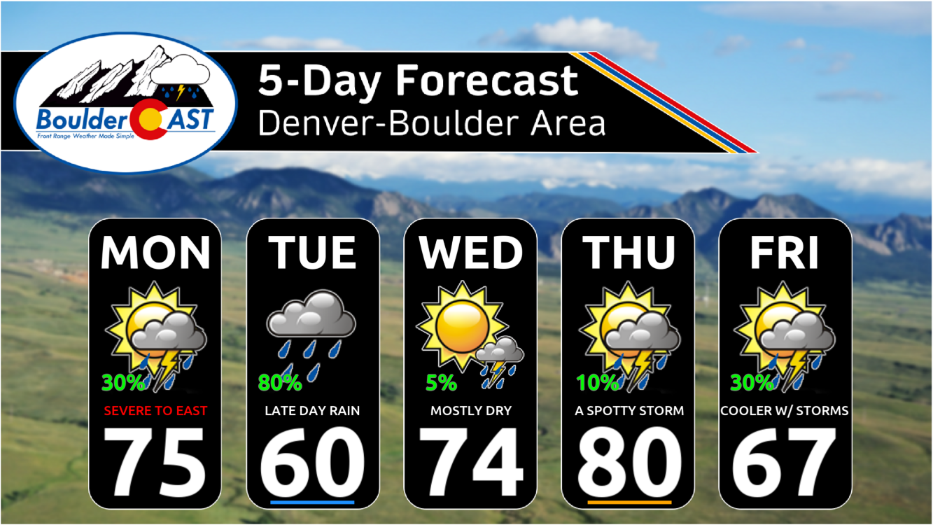
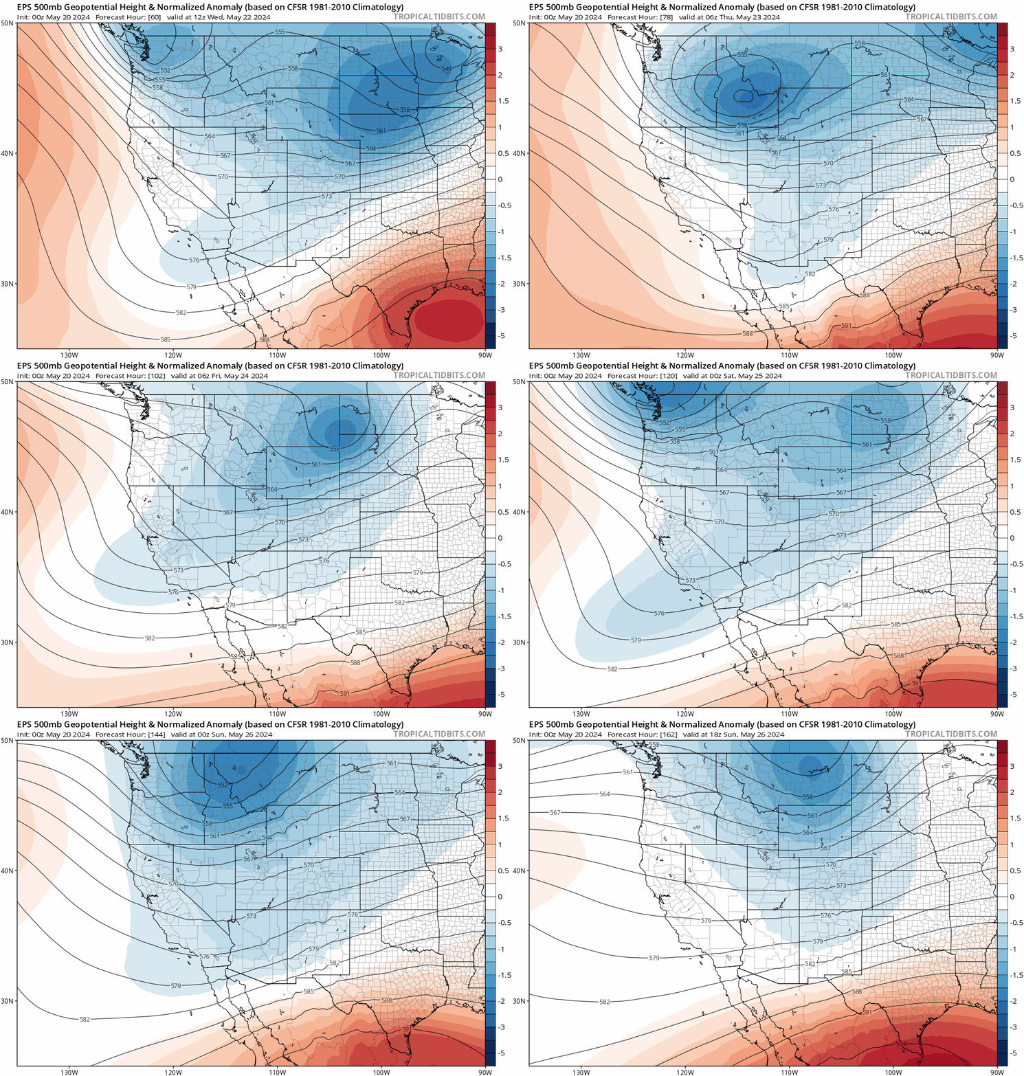
Unfortunately we won’t be able to kick the troughy, active weather pattern that has been plaguing the western United States anytime soon. Ensemble guidance continues to keep the risk of weak troughs over the northern Rockies throughout at least the next seven days, not fully clearing out until sometime next week. Most of the energy will remain north of Colorado, but not all of it. Each day Wednesday and beyond will come with at least a small risk of late-day showers and storms bubbling up. Wednesday will see high temperatures rebound to near normal in the middle 70s. Thursday will get close to 80 degrees. Both days will have about a 10% chance of late-day storms.
By Friday, yet another trough will be passing across Wyoming with a cold front trailing south into our area. The spread in model guidance is substantial late-week, so the forecast is a bit uncertain. The Euro wants to produce another decent round of rainfall for us, while the GFS/Canadian models just have isolated to widely scattered storms. Time will tell how things shake out for Friday, but for now expect a cooler conclusion to the week with highs in the 60s and a 20-30% chance of late-period rain. Enjoy the continued May showers!
It's that time of year… ❇️🌷💨 pic.twitter.com/t2PZxKhHRC
— BoulderCAST Weather 🏔️❄️ (@BoulderCAST) May 17, 2024
Get BoulderCAST updates delivered to your inbox:
Forecast Specifics:
Monday: Morning sun but increasing clouds by afternoon becoming overcast. Spotty thunderstorms will develop during the afternoon and head east, becoming severe well east of Denver with large hail, damaging winds and tornadoes possible across the eastern Plains. No severe weather in Denver area. Highs reach the middle to perhaps upper 70s on the Plains with middle 60s in the Foothills.
Tuesday: A bit of morning sunshine, then mostly cloudy with widespread showers and a few thunderstorms developing later in the day. Rain ends around midnight for the area. Cooler with highs only in the lower 60s at best for the Plains with upper 40s the Foothills. Some light snow accumulations (1-4″) is possible above 9500 feet.
Wednesday: Mostly sunny and warmer with a very slight chance of late-day storms, mainly across the higher terrain. Highs in the middle 70s for the Plains with lower 60s in the Foothills.
Thursday: A mix of clouds and sun and warmer. There could be a storm or two developing late in the day. Temperatures return to near 80 degrees on the Plains with upper 60s in the Foothills.
Friday: Some uncertainty due to model spread, but overall expect a cooler day with a decent chance of late-day showers and storms. Highs in the 60s across the Plains with 50s in the Foothills.
Weekend: The pattern stays somewhat active with continued late-day chances for showers and storms, albeit only isolated to widely scattered coverage is expected. Highs both Saturday and Sunday should be in the 70s.
DISCLAIMER: This weekly outlook forecast is created Monday morning and covers the entire upcoming week. Accuracy will decrease as the week progresses as this post is NOT updated. To receive daily updated forecasts from our team, among many other perks, subscribe to BoulderCAST Premium.
Daily Forecast Updates
Get our daily forecast discussion every morning delivered to your inbox.
All Our Model Data
Access to all our Colorado-centric high-resolution weather model graphics. Seriously — every one!
Ski & Hiking Forecasts
6-day forecasts for all the Colorado ski resorts, plus more than 120 hiking trails, including every 14er.
Smoke Forecasts
Wildfire smoke concentration predictions up to 72 hours into the future.
Exclusive Content
Weekend outlooks every Thursday, bonus storm updates, historical data and much more!
No Advertisements
Enjoy ad-free viewing on the entire site.
Enjoy our content? Give it a share!





You must be logged in to post a comment.