The week ahead will remain fairly active across Front Range Colorado as a series of upper-level disturbances track through the region with a broad trough of low pressure over the Four Corners and Intermountain West. Our warmest day will be Monday near 60 degrees, with cooler temperatures and unsettled weather taking over the remainder of the week. We are especially focused in on the Friday/Saturday timeframe when a strong storm system could bring several inches of spring snow to the area. Read on for more details.
This week’s highlights include:
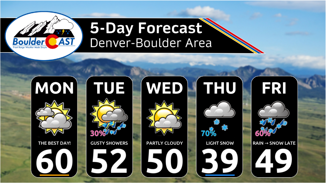
- Active week: Several shots of precipitation will exist, but the primary chances come late in the week into the upcoming weekend
- Temperatures: Near average highs on Monday (the nicest day of the week!) will fall below normal the rest of the week
- Snow chances: We’re tracking spotty rain/snow showers on Tuesday, but better chances for snow and actual accumulation come Thursday, Friday and into the weekend
- Significant Late-Week Snow? Some ensemble guidance suggests an anomalous snow event somewhere over Colorado Friday night through Saturday, but we have some concerns
DISCLAIMER: This weekly outlook forecast is created Monday morning and covers the entire upcoming week. Accuracy will decrease as the week progresses as this post is NOT updated. To receive daily updated forecasts from our team, among many other perks, subscribe to BoulderCAST Premium.

Go Premium, get all the perks.
Daily Forecast Updates
Get our daily forecast discussion every morning delivered to your inbox.
All Our Model Data
Access to all our Colorado-centric high-resolution weather model graphics. Seriously — every one!
Ski & Hiking Forecasts
6-day forecasts for all the Colorado ski resorts, plus more than 120 hiking trails, including every 14er.
Smoke Forecasts
Wildfire smoke concentration predictions up to 72 hours into the future.
Exclusive Content
Weekend outlooks every Thursday, bonus storm updates, historical data and much more!
No Advertisements
Enjoy ad-free viewing on the entire site.
Warm to start with slight precipitation chances
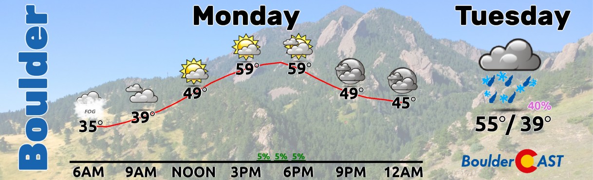
There is a lot to talk about in Front Range weather this week! As we close out March and enter the first few days of April, we’ll transition from seasonal temperatures in the 60s to eventual increasing snow chances by mid to late week. Buckle up as it is going to be an interesting one. After a wet weekend where much of the Front Range saw hefty rainfall totals, the first thunderstorms of the year, and even some snow mixed in Saturday night (several inches in the Foothills), the first day of our work week will start off relatively mild and quiet. A warm front will lift through Monday afternoon, reaching southwest Nebraska by the evening.
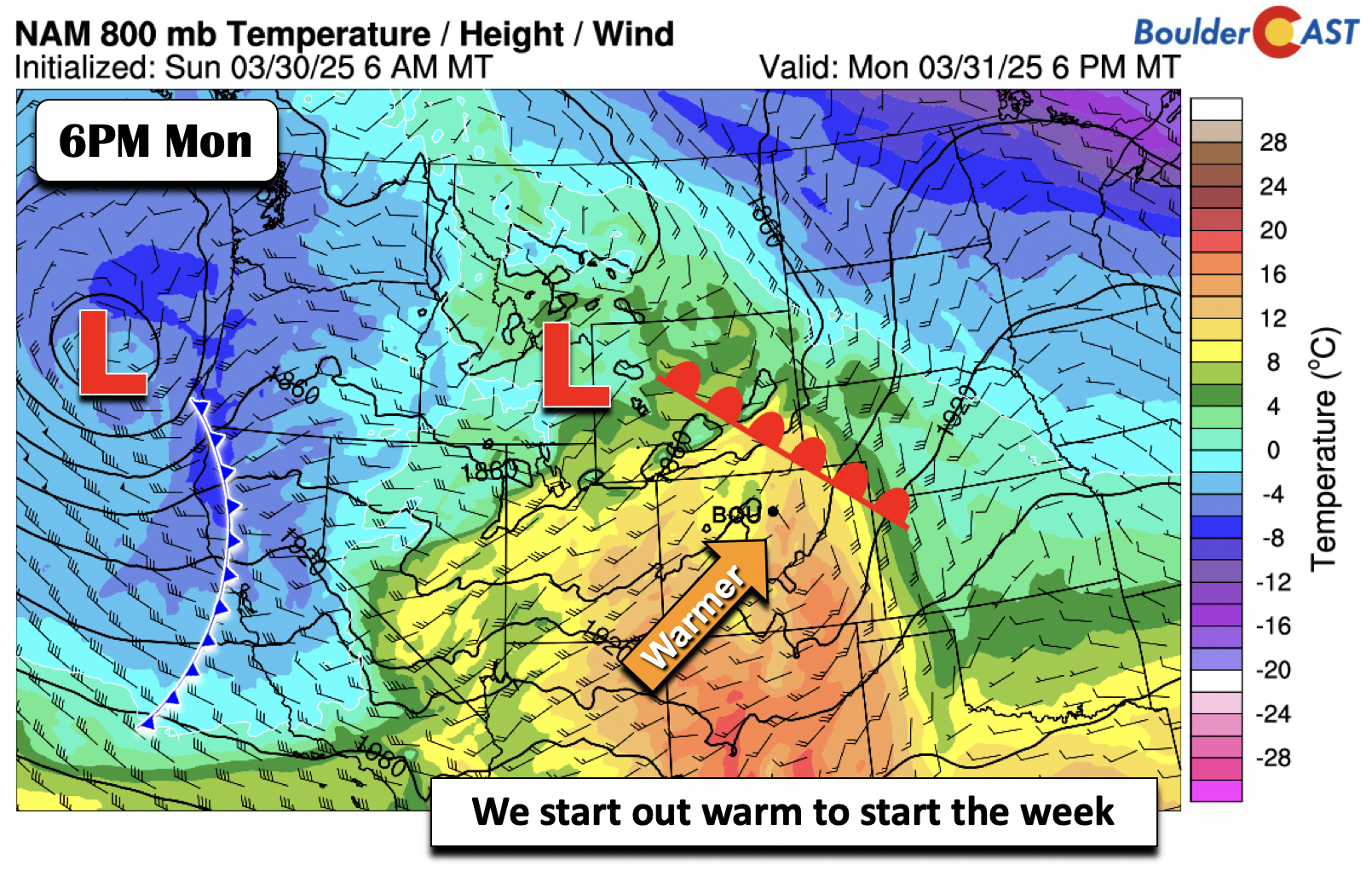
Southerly flow will push our highs on Monday into the lower 60s. Enjoy this brief return to milder weather if you can — Monday will likely be our nicest weather day of the entire week!
The first in a series of shortwave disturbances will build eastward Monday night into Tuesday. As we will discuss a bit later, a large trough will set-up shop over the western part of the United States this week, allowing several systems to move eastward into Colorado. This first shortwave will bring marginal rain chances to the Plains overnight, with the best chance Tuesday morning.
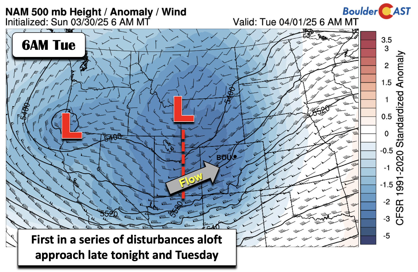
As the disturbance moves east Tuesday, an area of low pressure tracks into the Dakotas, with a trailing cold front sweeping through northeast Colorado during the morning hours. While some rain/snow showers will be possible sprinkled throughout the day, northwest downslope winds should keep us largely dry here in the Denver Metro area. These winds will gust at times up to 35 MPH, along with highs landing cooler in the lower 50s.
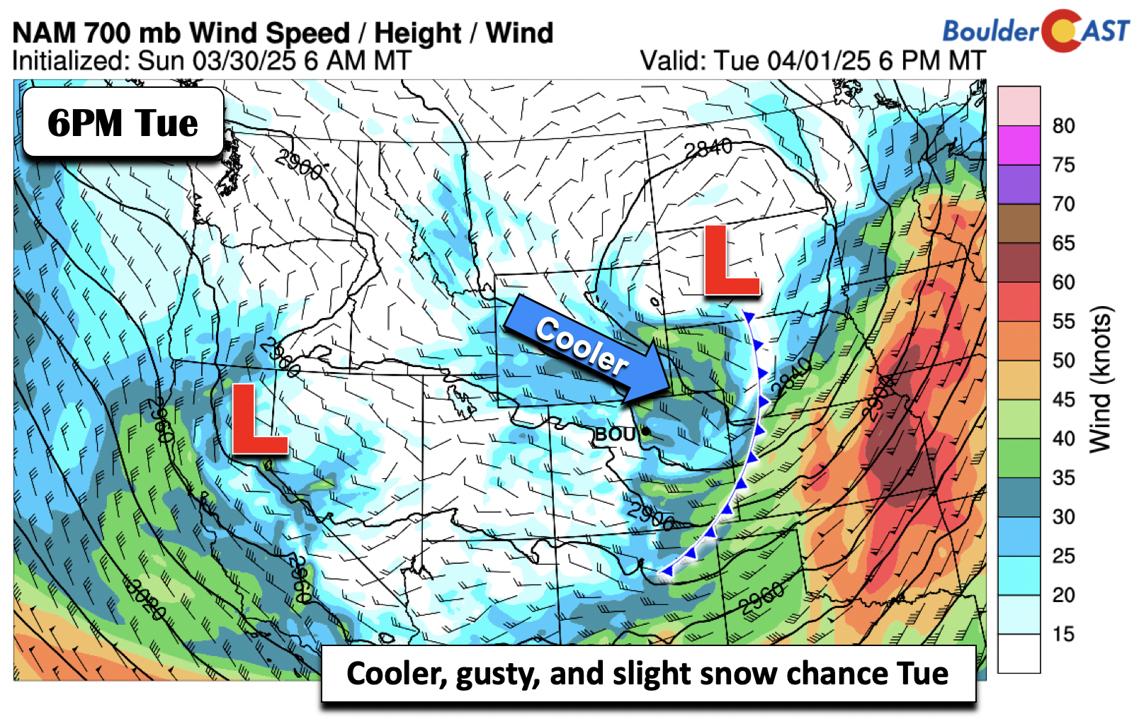
A period of weak upslope Tuesday night and forcing aloft will warrant a chance of light snow or flurries into early Wednesday. Snow levels will dip below 5000 ft, meaning that any precipitation will likely not be liquid.
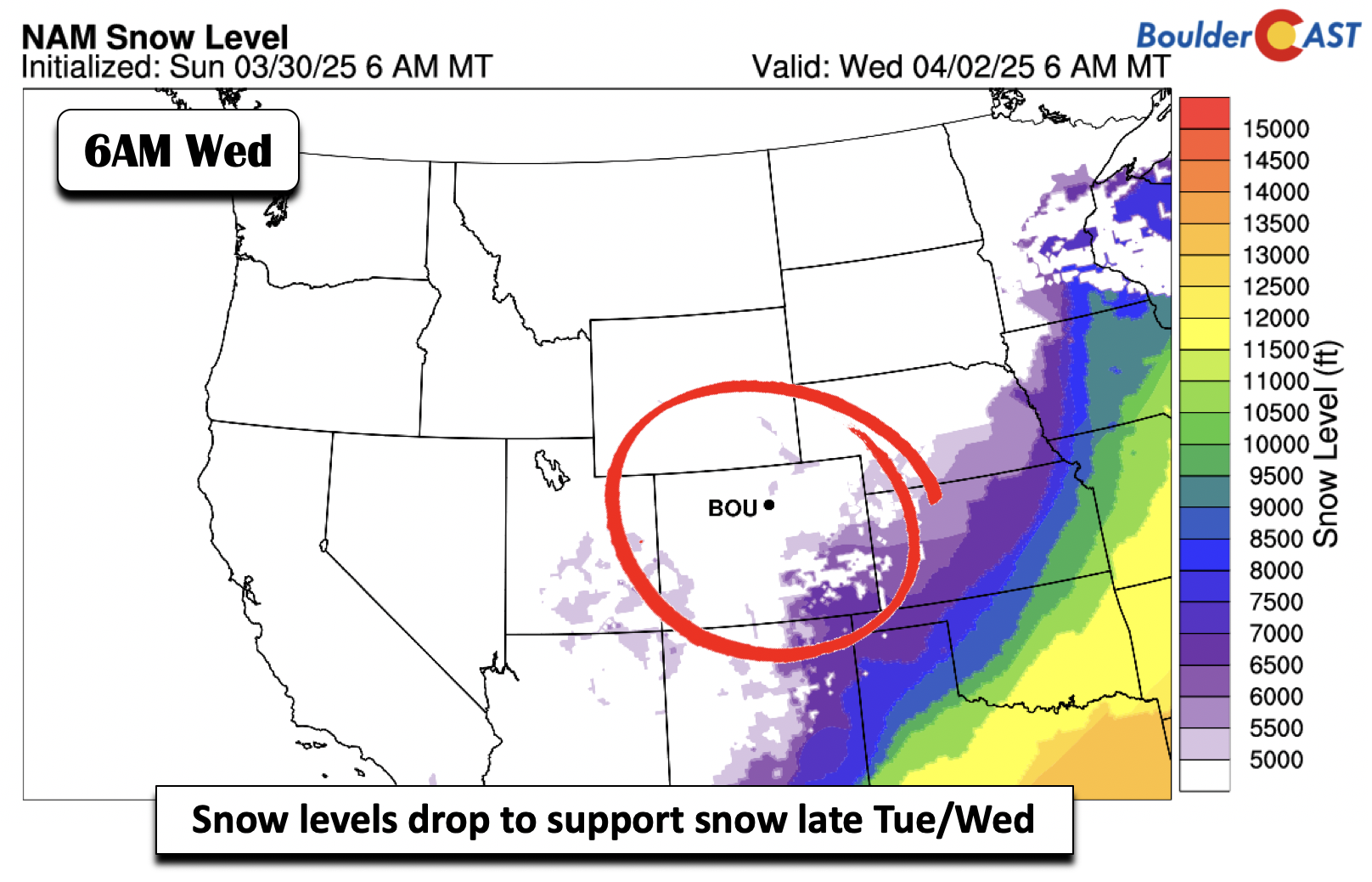
The good news is that the amount of actual precipitation into Wednesday will be rather light given the downslope nature, at least for the Plains. The westerly flow aloft on Tuesday into Wednesday morning will spell out upslope snow across the High Country, with some spillover snow showers over the Foothills as well. A few inches may fall west of Boulder up along Peak-to-Peak Highway. Little if any accumulation is expected below 8000 feet elevation through Wednesday. We’ll continue our downward trend in highs on Wednesday with temperatures landing around 50 degrees.
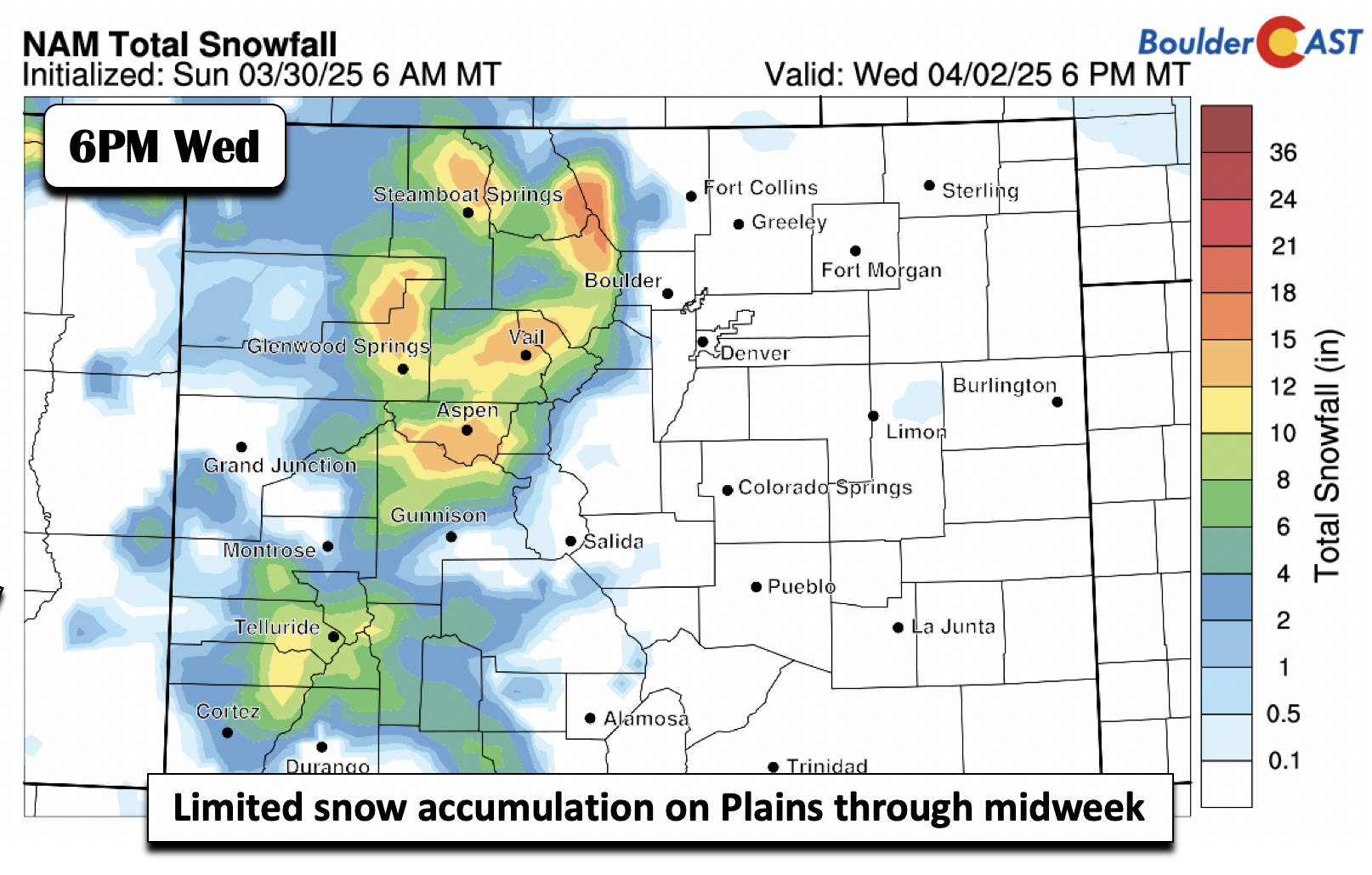
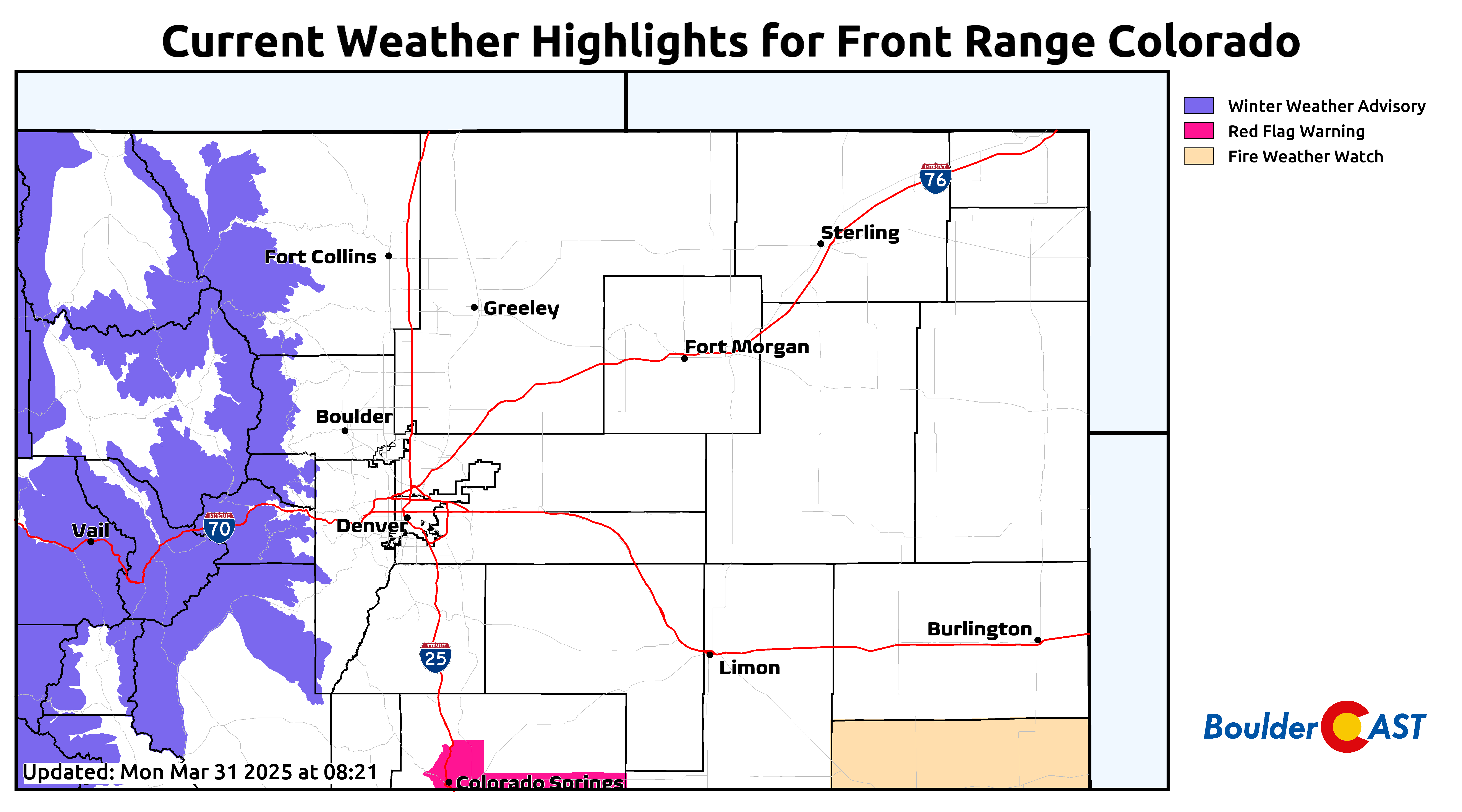
Winter Weather Advisories go into effect Monday at 9PM in the Mountains, lasting through Wednesday at 6AM. Plan for winter travel conditions at times during this window up there when blustery winds overlap with up to 10 inches of fresh snow.
Better chances for accumulating snow mid to late week
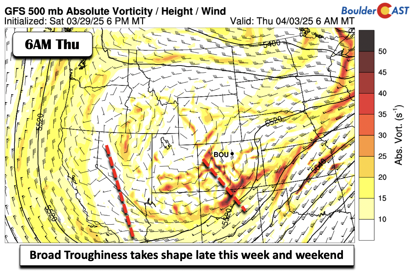
The pattern turns much more unsettled, and potentially more fruitful for us, after Wednesday, with hints for a potent late winter storm system possible. We’ll also see highs continuing to fall below average. The broad trough pattern over the Intermountain West to Four Corners area will be in full swing on Thursday. While the main circulation is somewhere over Utah and Nevada, guidance shows another ripple of energy moving in on Thursday.
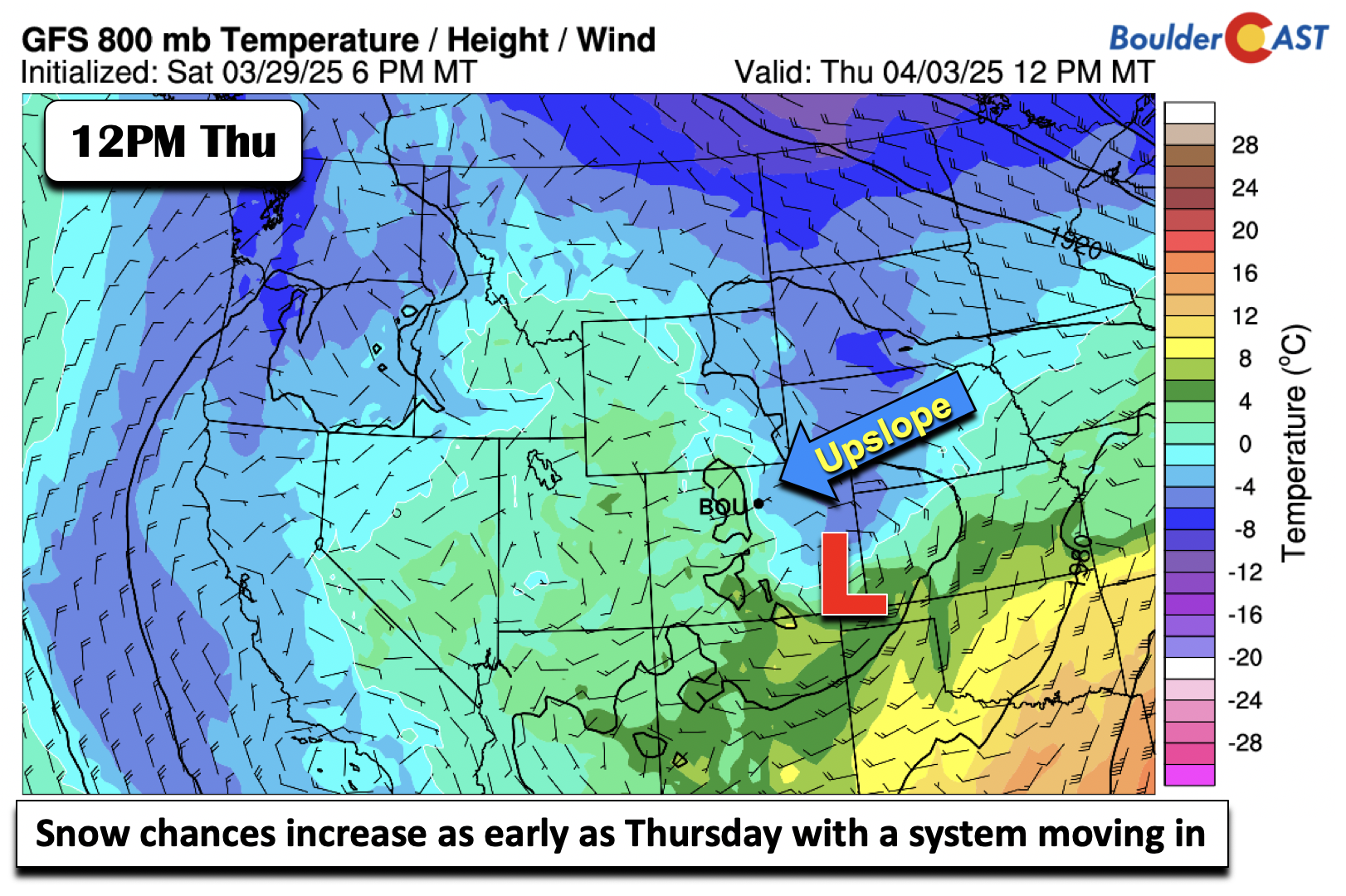
The departing system on Wednesday combined with a developing surface low will bring a cold front through sometime early Thursday. The low-level airmass will fall below freezing just above the surface by this time, at least suggested in the GFS, but also supported partly by the Euro and Canadian models. Upslope, in tandem with this cold air, will favor increased chances for snow during the day into evening. Temperatures should top out in the upper 30s or so, plenty cold enough for whatever materializes to be all or mostly snow across the Boulder-Denver area. Amounts are difficult to pinpoint right now given no clear agreement on the track of the parent low, but it will certainly bear watching. Most model data available at this early juncture indicates this weak storm will pass mostly southeast of Denver, with areas around Colorado Springs and the Palmer Divide favored for several inches of snow. We should still see some light accumulations here on Thursday, but likely not that much.
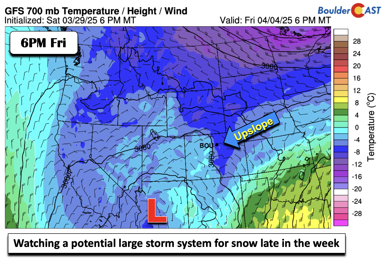
Thursday’s system is not the only one taking aim on the Front Range! The ECMWF, GFS, CMC, and the Euro ensembles are hinting that a more potent system could impact the region late Friday through Saturday. Guidance does not agree on the overall trough pattern, but does indicate a circulation center near or south of the Four Corners area, with anomalous moisture channeling northward into Colorado. At the same time, upslope northeast flow and cold air will likely be entrenched at the low-levels.
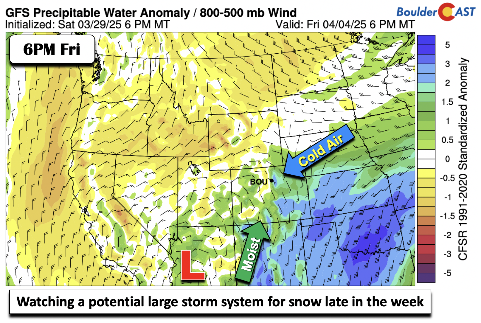
The GFS indicates east to northeasterly upslope at 700 mb (~5000 ft above Boulder and Denver), with low pressure over Arizona. The parent low pressure begin so far away generally doesn’t bode well for seeing significant precipitation here, but the exact evolution of things late-week remains uncertain, but has been trending further south and west — with lessening threat of heavy snow in the Front Range. Highs on Friday are going to be tricky as well, but most likely we won’t get out of the 40s.
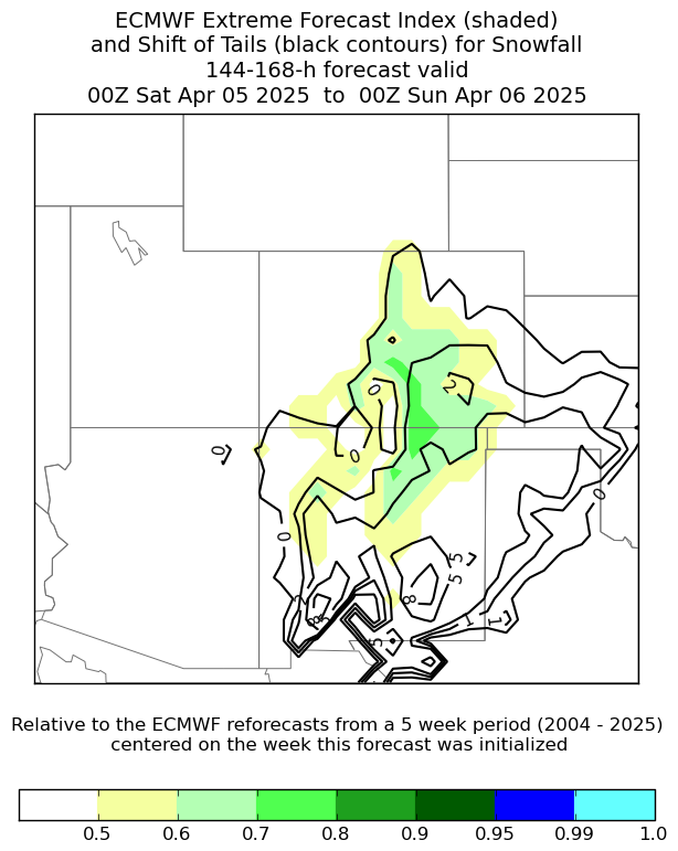
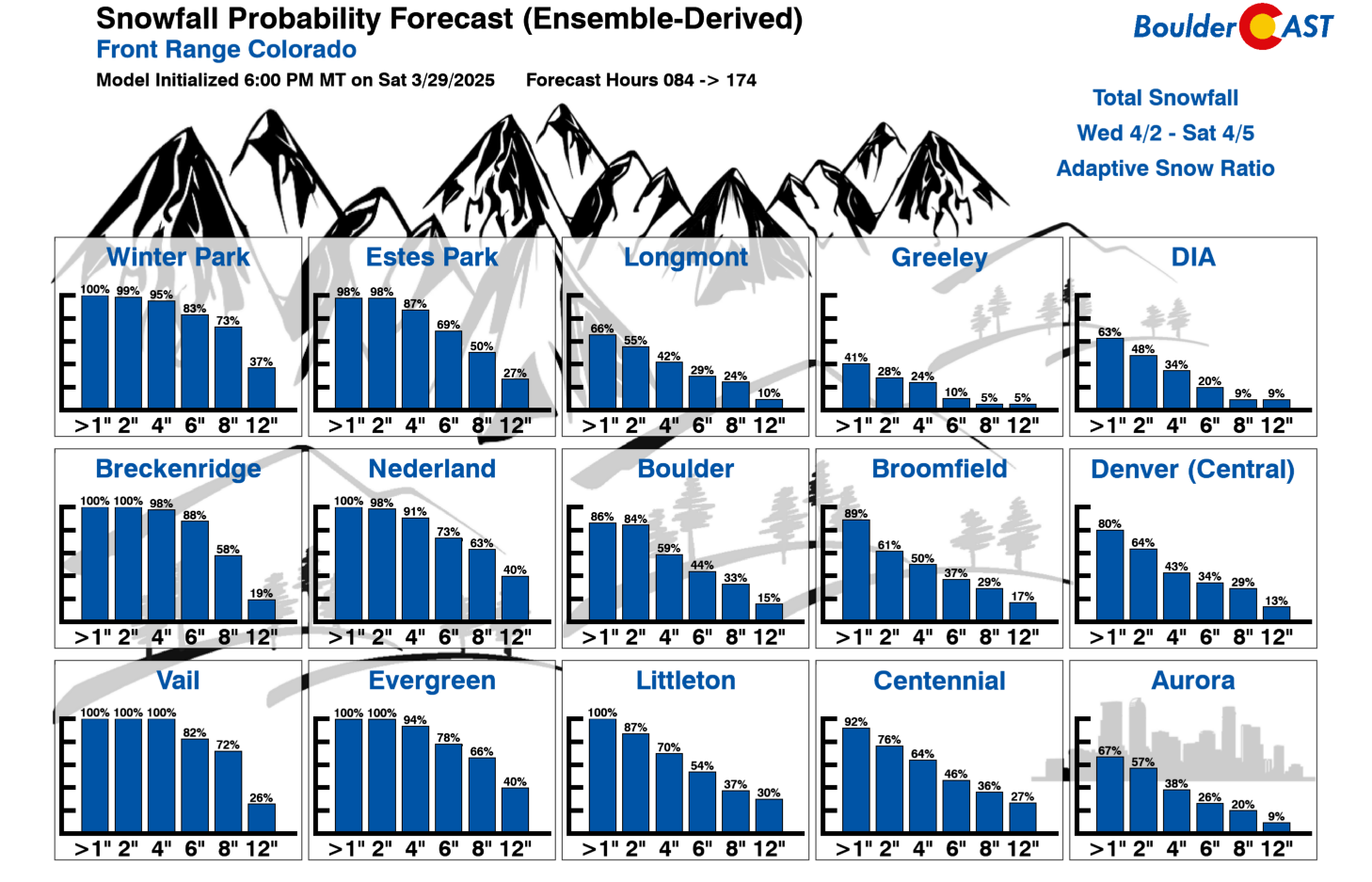
Let’s take a look at the ensemble guidance for this late-week system. The bottom left is the ECMWF ensemble extreme forecast index, while the bottom right shows snowfall probabilities late Wednesday through Saturday. The ECMWF ensemble index essentially highlights that portions of the Front Range to southeast and south-central Colorado have the potential to see anomalous snowfall. This does not mean a certainty, just that some Euro ensemble members are indicating snow amounts near the higher end of the distribution. Our in-house GEFS snowfall probabilities are in similar agreement. There is about a 40% to 60% chance of 4 or more inches across the Front Range cities, with Boulder near the higher end of that range.
 |
 |
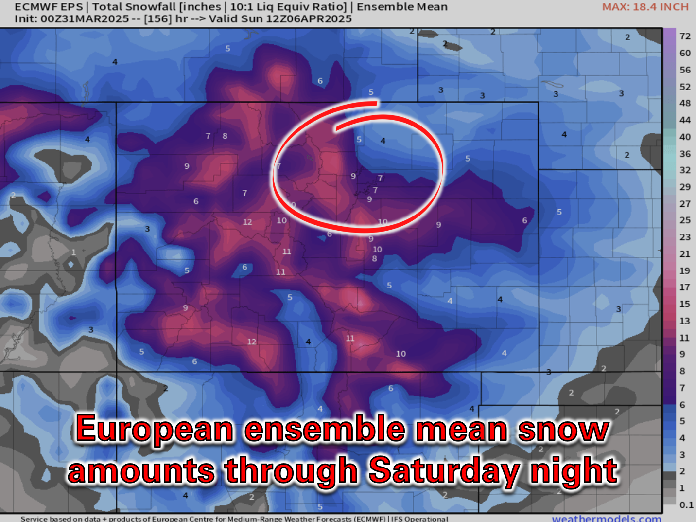
Given this is a complex storm system and still five days out, coupled with the early spring sun angle, potential snow amounts are still uncertain for the period of late Friday through Saturday. The best forecast for now is the European ensemble mean forecast below which shows 4 to 8 inches of accumulation in the Metro area. Stay tuned for updates on the impending wintry weather through the week and be sure to follow us on Twitter, Bluesky, Facebook, and Threads for impromptu weather updates in the coming days, or subscribe to get notified of our long-form updates here.
Forecast Specifics:
Monday: Morning fog, then partly to mostly cloudy through the day. Warmer than prior days with highs around 60 degrees on the Plains with upper 40s in the Foothills.
Tuesday: A chance of morning and afternoon isolated rain or snow showers. Blustery conditions through much of the day with gusts up to 35 MPH at times from the west-northwest. Highs in the lower 50s on the Plains with upper 30s in the Foothills. There will be a chance of snow or flurries Tuesday evening and night, but any accumulation should remain only in the higher Foothills (less than 3″).
Wednesday: Partly cloudy skies and mostly dry. Temperatures will be in the lower 50s on the Plains and near 40 in the Foothills.
Thursday: A colder day with a good chance for light snow in the Metro area. Highs top out only in the upper 30s on the Plains with upper 20s in the Foothills. Accumulations are expected to be light (less than 3″).
Friday: Partly to mostly cloudy with a chance for late-day rain changing to snow during the evening or overnight. Highs in the upper 40s on the Plains, with middle 30s in the Foothills.
Weekend: Unsettled conditions with snow continuing on through Saturday. Exact snow amounts for this event remain uncertain, but several inches are possible across the lower elevations and Foothills alike. Temperatures are set to remain chilly and below average through the weekend.
Get BoulderCAST updates delivered to your inbox:
DISCLAIMER: This weekly outlook forecast is created Monday morning and covers the entire upcoming week. Accuracy will decrease as the week progresses as this post is NOT updated. To receive daily updated forecasts from our team, among many other perks, subscribe to BoulderCAST Premium.
Go Premium, get all the perks.
Daily Forecast Updates
Get our daily forecast discussion every morning delivered to your inbox.
All Our Model Data
Access to all our Colorado-centric high-resolution weather model graphics. Seriously — every one!
Ski & Hiking Forecasts
6-day forecasts for all the Colorado ski resorts, plus more than 120 hiking trails, including every 14er.
Smoke Forecasts
Wildfire smoke concentration predictions up to 72 hours into the future.
Exclusive Content
Weekend outlooks every Thursday, bonus storm updates, historical data and much more!
No Advertisements
Enjoy ad-free viewing on the entire site.
Enjoy our content? Give it a share!


You must be logged in to post a comment.