
A wide range of weather and temperatures are expected this week as spring and winter continue to mingle. We’ll warm-up nicely through Wednesday into the 60’s, but another round of snowfall is taking aim on the Front Range for Thursday.
This week’s highlights include:
- A weak system brings a slight chance of rain showers Monday afternoon/evening
- Highs warm-up Tuesday and Wednesday into the 60’s, mostly dry
- Watch for rain changing to snow on Thursday, accumulations possible
- A chilly, but quiet end to the week on Friday

DISCLAIMER: This weekly outlook forecast is created Monday morning and covers the entire upcoming week. Accuracy will decrease as the week progresses as this post is NOT updated. To receive daily updated forecasts from our team, subscribe to BoulderCAST Premium.

Small chance of rain Monday
We begin with the week with a feeble weather system moving across the southern Rockies. As of Monday morning, a shortwave trough is draped from north to south across far western Colorado. This trough will move eastward through the rest of the day bringing with it a chance of precipitation for the region. Most of the energy, what little there is, will remain south of our area across southern Colorado and New Mexico.
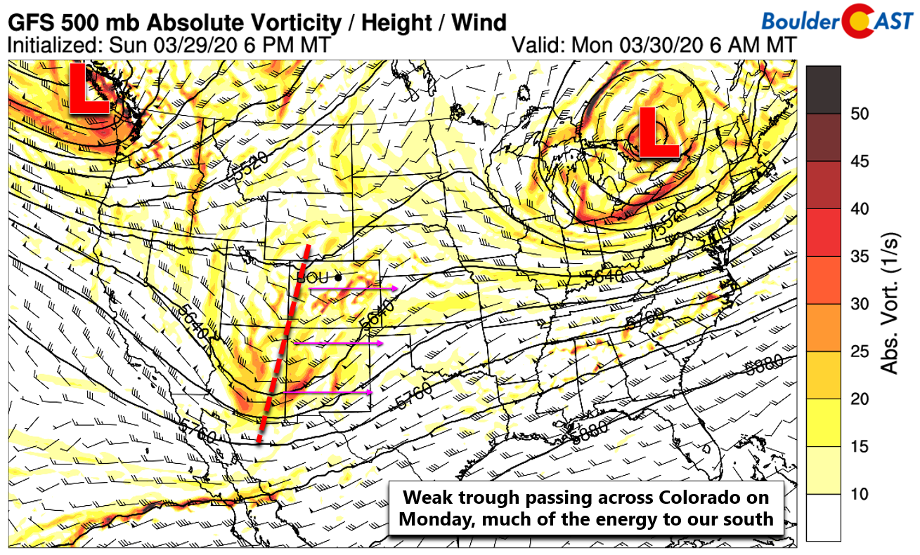
However, as of Monday morning, there are already a few rain showers on radar across far northeast portions of the state, as well as widespread snow showers in the Mountains of western Colorado.

Colorado radar animation as of Monday morning
This energy will push east and produce a light round of snowfall in the Mountains and a small chance of afternoon and early evening rain showers across the lower elevations of the Denver Metro area. Model soundings are showing widespread but weak CAPE present across the area today (see below), though profiles don’t look all that favorable for thunderstorms. Nonetheless, spotty rain showers should form across the Front Range primarily from the afternoon into early evening on Monday, just a 10-20% chance. We can’t rule out a few rumbles of thunder, but odds look rather low. Due to a dry lower atmosphere, rainfall amounts will be light but brief gusty outflow winds will accompany any showers. Highs on Monday are expected to top out in the middle 50’s under partly to mostly cloudy skies.

A warm & sunny Tuesday (and Wednesday?)
Tuesday will turn warmer and sunnier across the Front Range as a brief lull in weather activity occurs for the area. Monday’s weak disturbance will have departed into the southern Plains while another storm system and cooperating cold front will be approaching from the north. This will leave us with a pleasant day in-between systems under dry and mild southwest flow. Expect mostly sunny skies and temperatures topping out in the middle 60’s for Tuesday.
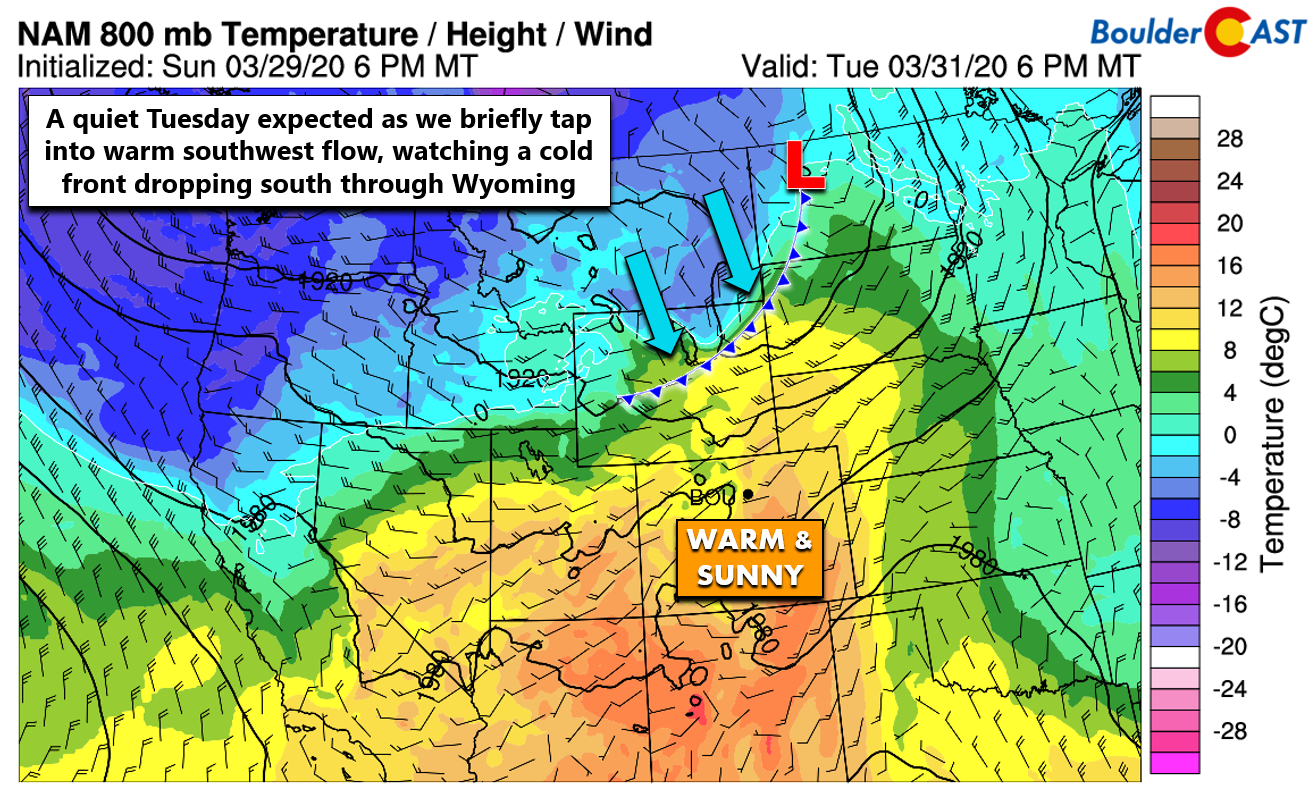
Wednesday the forecast becomes slightly more challenging as the aforementioned cold front drops south out of Wyoming and may impact northeast Colorado in the morning. It’s unclear exactly how far south this front will push. Both the GFS and NAM models do bring the cold front into Denver and Boulder during the morning hours Wednesday. However, the front is expected to then retreat quickly in both models allowing for another warm day with highs in the middle to upper 60’s. But, we stress that the precise position of this stalled front is a tricky forecast. A very similar set-up unfolded last Thursday where models also showed a cold front retreating northward through the day, but it never did. This left much of the Metro area in the 40’s instead of the predicted middle 60’s! At this time, however, it does appear Wednesday will be a warm one, but do be cautious for the chance of a colder day.

Trending colder & unsettled beginning Wednesday evening
We have higher confidence that the cold front will then slide back southward Wednesday evening and night, aided by a stronger storm system approaching from the Pacific Northwest (below on left). This will initially spawn a few rain showers across the area, but these will be very scattered in nature and will mainly be focused north and east of the Front Range. On Thursday, a secondary, stronger cold front is expected to surge southward into the Metro area. This will offer a good chance of rain changing to snow for the lower elevations and all snow in the Foothills. It’s too early for any specifics with this system, but it certainly does offer our best chance of precipitation for the week at this time.
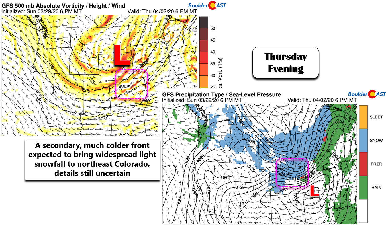
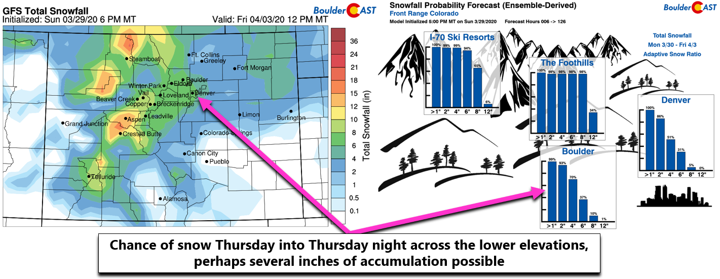
Highs Thursday will drop into the 40’s with possible falling temperatures through the day as rain eventually changes over to snow. We’ll continue to monitor the situation, but it appears that light snow accumulations will be possible across Boulder and Denver. The GFS model currently predicts this to be a 2-5″ type of event, while the Euro is indicating more like 1-3″. We’ll continue to monitor this system as the week progresses and post a forecast update if any snow appears imminent.
After an unsettled Thursday, we’ll begin to dry out and quiet down Friday and beyond. Temperatures stay cool in the 40’s but should increase significantly come the weekend back into the 50’s and 60’s with no major weather systems expected at this time for Colorado.
Subscribe to receive email notifications for BoulderCAST updates:
We respect your privacy. You can unsubscribe at any time.
.
Forecast Specifics:
Monday: Partly to mostly cloudy with isolated afternoon and evening rain showers accompanied by brief gusty winds. A rumble or two of thunder is also possible. Highs in the middle 50’s on the Plains and lower 40’s in the Foothills.
Tuesday: Mostly sunny and warmer. Highs in the middle 60’s on the Plains and near 50 in the Foothills.
Wednesday: Increasing clouds with a slight chance of evening rain showers continuing into the overnight hours. High temperatures are slightly uncertain, but we’re predicting middle to upper 60’s for the Plains and lower 50’s in the Foothills.
Thursday: Much cooler with small chance for some morning sun, but quickly turning overcast and gloomy with rain showers changing to snow through the day. Light snow accumulations are possible through the evening and overnight. Highs in the middle 40’s on the Plains and middle 30’s in the Foothills (falling late in the day).
Friday: Morning clouds turning partly sunny. Highs remain cool in the low to middle 40’s on the Plains and in the lower 30’s in the Foothills.
High Country: Light snow accumulations are expected with the first passing wave of the week on Monday across most of the High Country (2-5″). After a dry Tuesday and Wednesday, widespread snow returns Wednesday night into Thursday night with moderate snowfall amounts expected. There is still some uncertainty but 5-10″ may be possible in many ranges. Check our PowderCAST page for always-updated weather forecasts for all of the Colorado ski resorts.

Help support our team of Front Range forecasters by joining BoulderCAST Premium. We talk Boulder and Denver weather every single day. Sign up now to get access to our daily forecast discussions each morning, complete six-day skiing and hiking forecasts powered by machine learning, first-class access to all our Colorado-centric high-resolution weather graphics, bonus storm updates and much more! Or not, we just appreciate your readership!
.
Spread the word, share our forecast!


You must be logged in to post a comment.