This week’s weather in Colorado will be dominated by a potent ridge of high pressure setting up shop across New Mexico. Although chances of storms will exist for Monday and Tuesday, model guidance shows better agreement for more numerous thunderstorm activity during the latter part of the week as a few weak fronts move into the region and moisture levels increase across the Front Range. High temperatures will be close to record values early in the week, but trend downward slowly by week’s end. Read on for more details.
This week’s highlights include:
- Anomalous high pressure ridge: This week’s weather will be controlled by a strong ridge of high pressure to our south
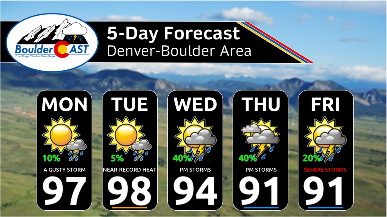
- Very hot early week: It will remain very hot and largely dry to start the week. Highs will generally be in the mid to upper 90s with only meager chances of rain Monday and Tuesday
- Rain chances ramp up: Rain chances will trend up Wednesday onward as both a few fronts and moisture levels combine over the region. There may even be a few severe storms around come Friday.
- Cooler for the weekend: Most signs point to a cooldown this weekend with temperatures falling back into the 80s. However, any cooldown will be short-lived with a quick return to the 90s expected.
DISCLAIMER: This weekly outlook forecast is created Monday morning and covers the entire upcoming week. Accuracy will decrease as the week progresses as this post is NOT updated. To receive daily updated forecasts from our team, among many other perks, subscribe to BoulderCAST Premium.

Go Premium, get all the perks.
Daily Forecast Updates
Get our daily forecast discussion every morning delivered to your inbox.
All Our Model Data
Access to all our Colorado-centric high-resolution weather model graphics. Seriously — every one!
Ski & Hiking Forecasts
6-day forecasts for all the Colorado ski resorts, plus more than 120 hiking trails, including every 14er.
Smoke Forecasts
Wildfire smoke concentration predictions up to 72 hours into the future.
Exclusive Content
Weekend outlooks every Thursday, bonus storm updates, historical data and much more!
No Advertisements
Enjoy ad-free viewing on the entire site.
The heatwave continues…
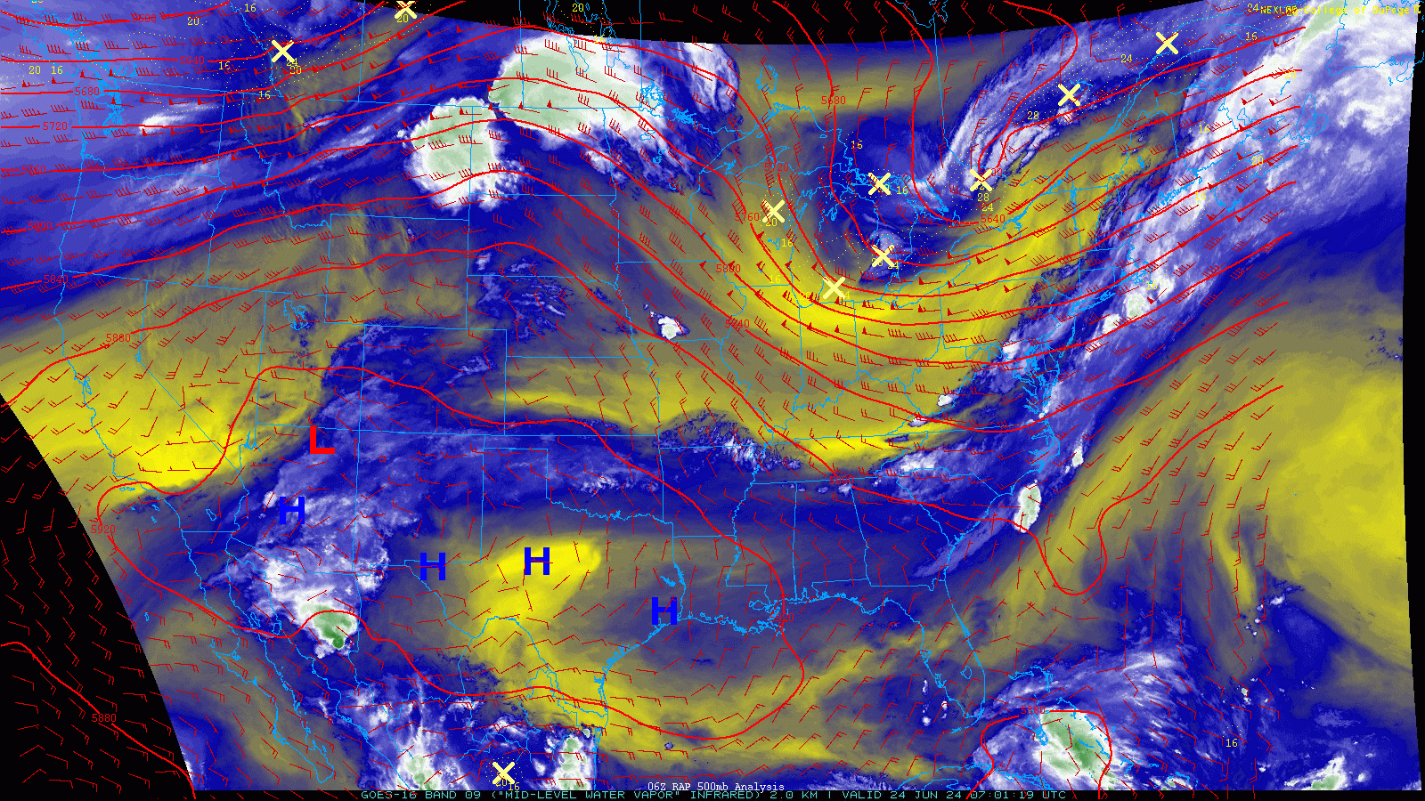
The weather week ahead in Colorado will largely be controlled by a broad subtropical high pressure moving into in the southern Rockies and intensifying the next few days to come. As seen from Monday morning’s GOES-East water vapor animation, the offending high pressure is currently centered over Texas.
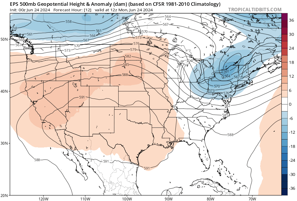
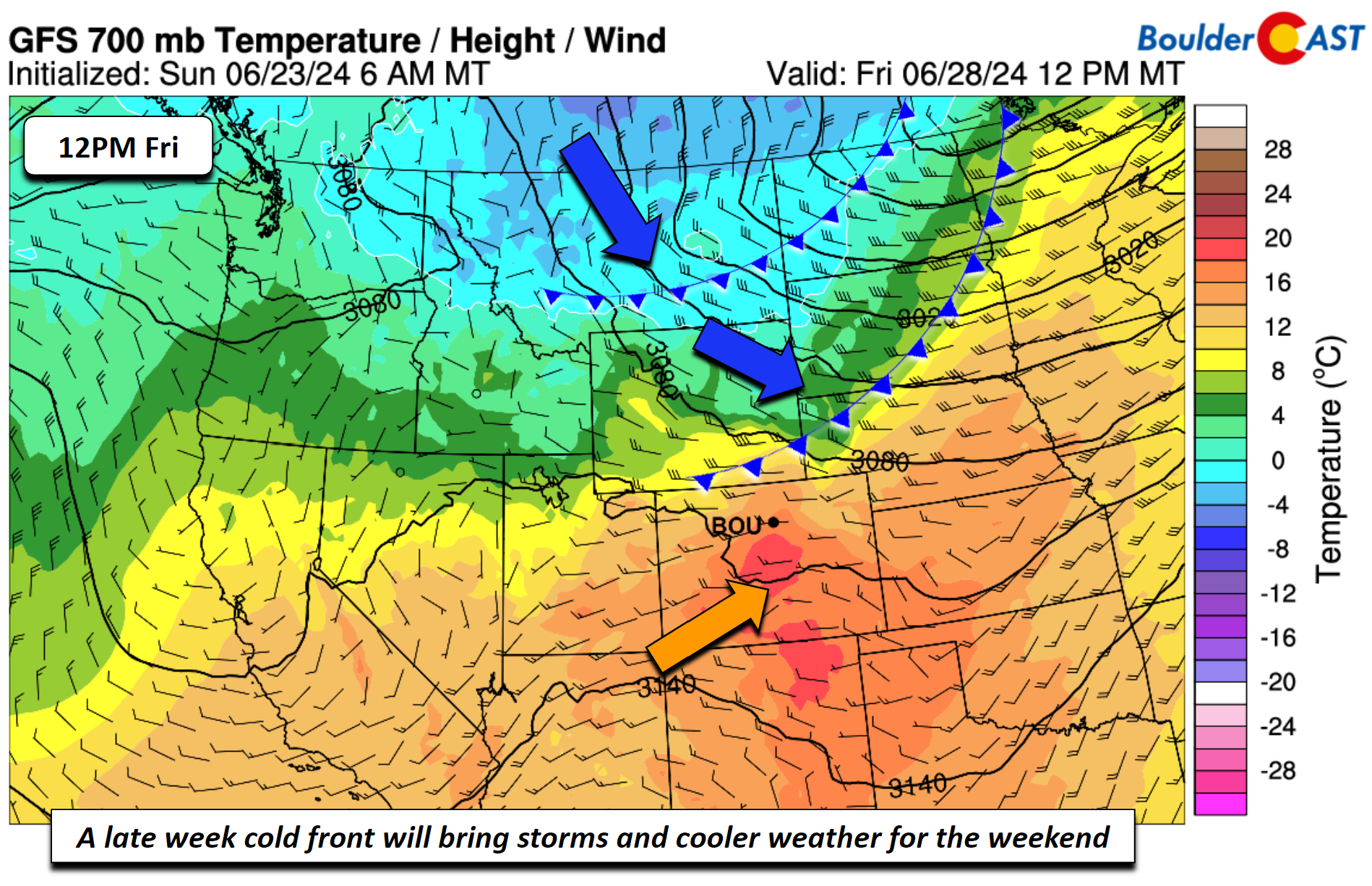
This ridge will edge further west and strengthen across New Mexico as we head into mid-week. By Thursday and Friday, a disturbance coming onshore from the northeast Pacific Ocean will flatten the ridge back southward. This should bring our temperatures down somewhat alongside more substantial chances for late-day thunderstorms.
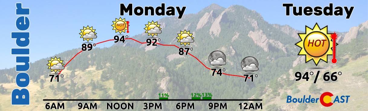
Early in the week hot conditions will persist, although the chances of storms cannot be ruled out to start our Monday. We pick up where we left off from Sunday with temperatures in the mid to upper 90s once again.
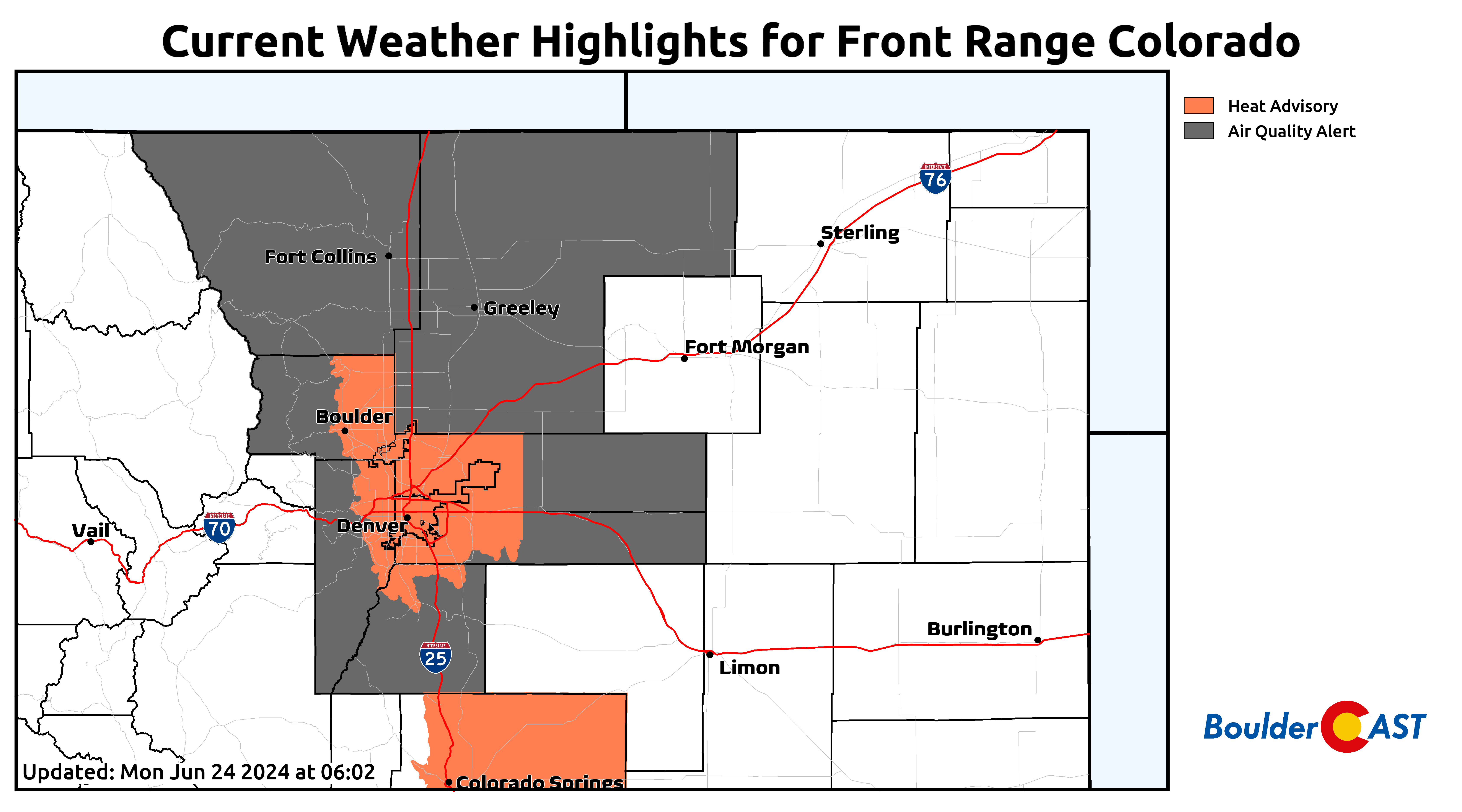
Heat Advisories and Air Quality Alerts (for ozone) unfortunately overlap across the Denver Metro area and that will be the case several days, if not every day, this week.
A weak shear axis will aid mid-level lift for some shower and storm development Monday afternoon and evening. High pressure will be displaced just enough to allow moisture levels to uptick a tad and bring storms to the higher terrain and possibly the Foothills. These storms will be isolated on the Plains, with chances at about 10%. Any storms that do make it into the Metro area would offer gusty winds but little in the way of rainfall.
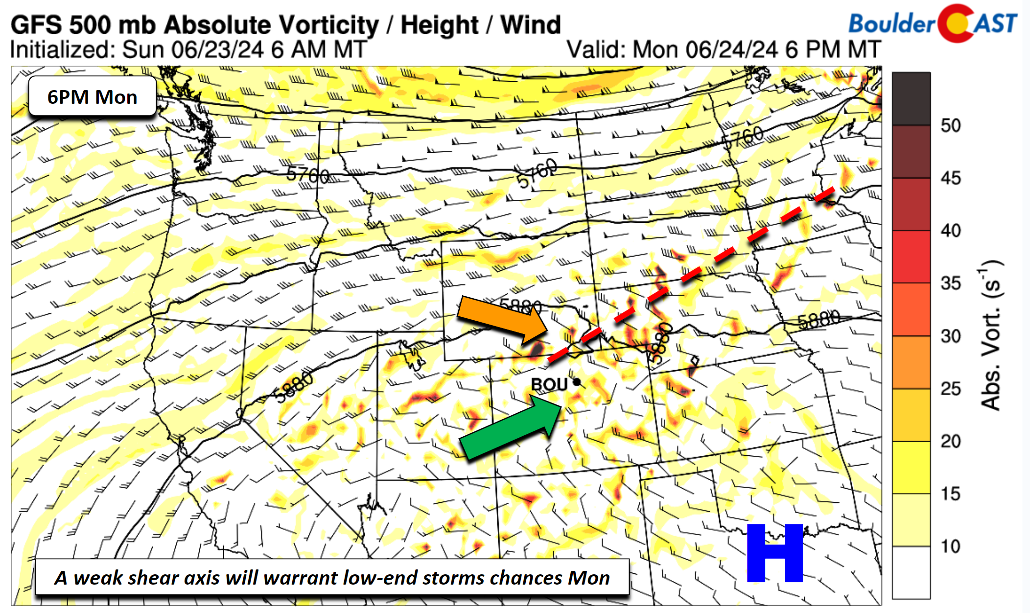
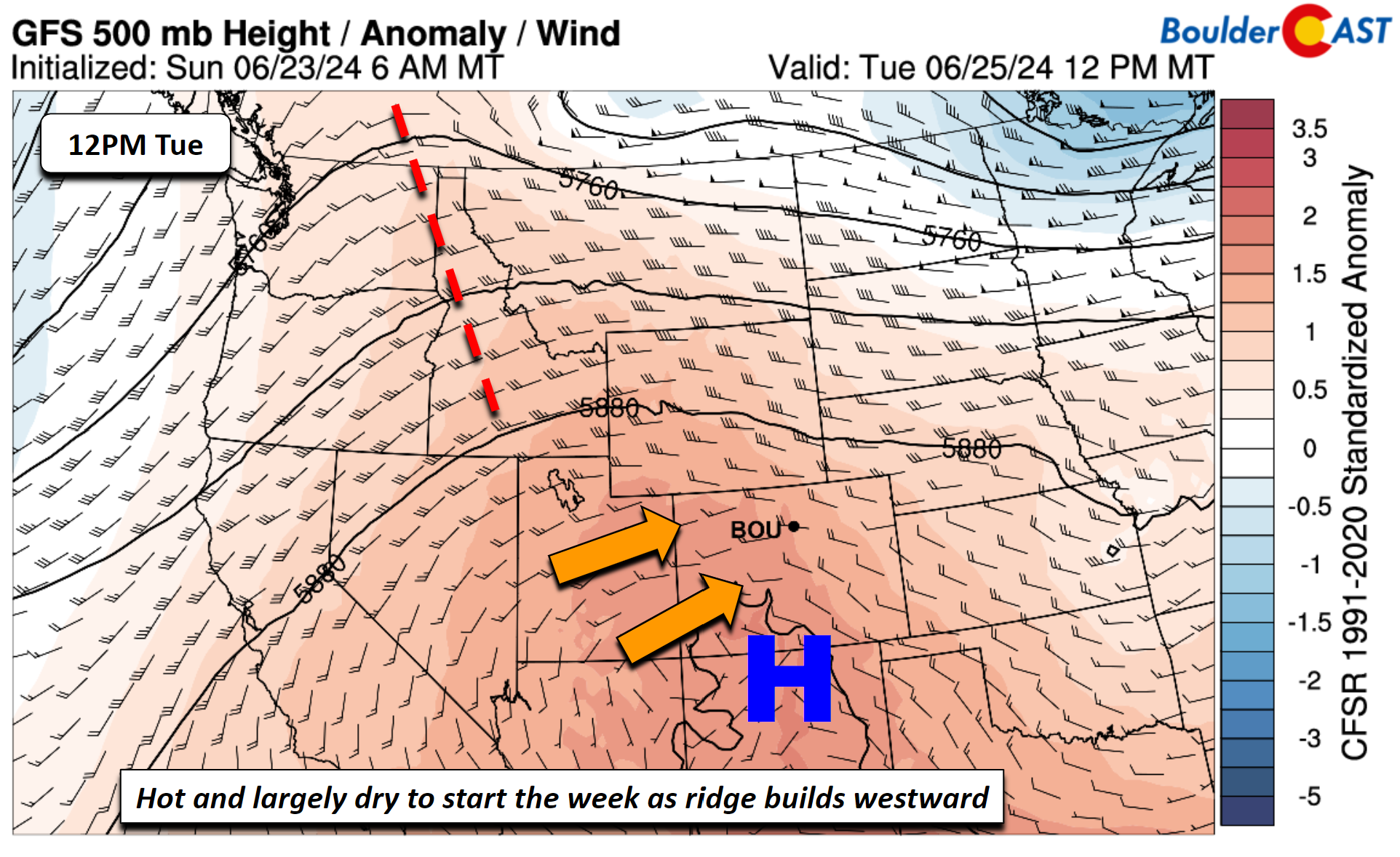
Monday’s shear axis may actually bring a very weak front or surface trough through the region Tuesday morning. However, the airmass will change little, if any, as a result. In fact, it looks to warm ever-so-slightly as the ridge of high pressure shifts more towards the Four Corners. That movement should blast our highs back into the mid to upper 90s Tuesday while at the same time shunting any real threat of precipitation to a few higher terrain locations as drier air holds strong. Tuesday could be our hottest day of the week, though it’s really just splitting hairs…
Better rain chances return Wednesday
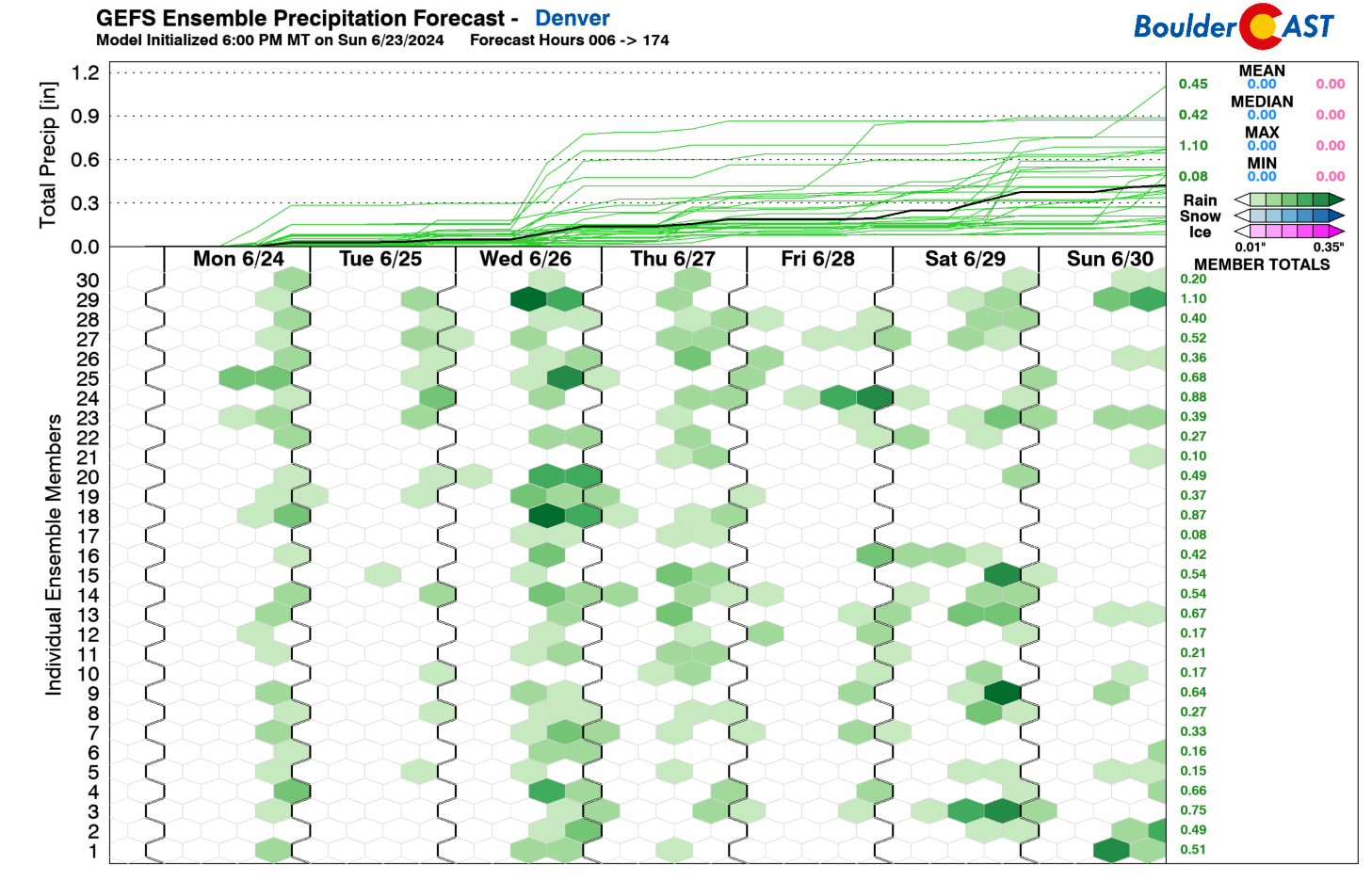
As we go through the mid to latter part of the week, storm chances, like we endured last week, are favored to ramp up, with the GEFS showing the highest confidence of this on Wednesday. Nearly every ensemble member has measurable rain on Wednesday, though Thursday and Friday are favorable too. This uptick in rain chances will be coincident with a few frontal systems that should eventually break down the ridge, at least temporarily, to bring somewhat cooler temperatures by late week and into the weekend.
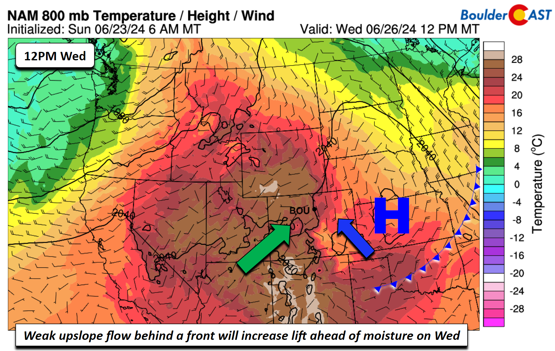
Models show a weak cold front that may become ill-defined either late Tuesday or early Wednesday as a wind shift settles across the southern/central Plains to Midwest. Behind it, we will see a slight lowering of highs Wednesday into the low to mid 90s. But more importantly, an east-southeast upslope flow will develop with high pressure to our east ushering in better low-level moisture.
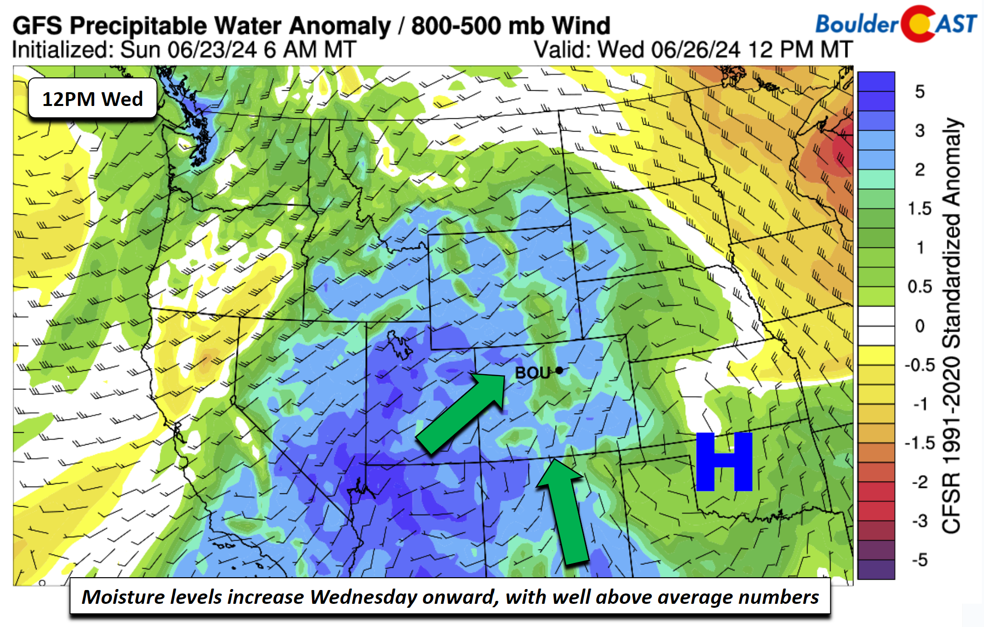
On top of the moist southeast surface flow, the mid to upper levels will bring in anomalous moisture from the southwest with precipitable water values rising above 1 inch. We’ll see some influence from both the high shifting east and a trough over the Pacific Northwest, fueling a favorable moist flow building in from the Desert Southwest.
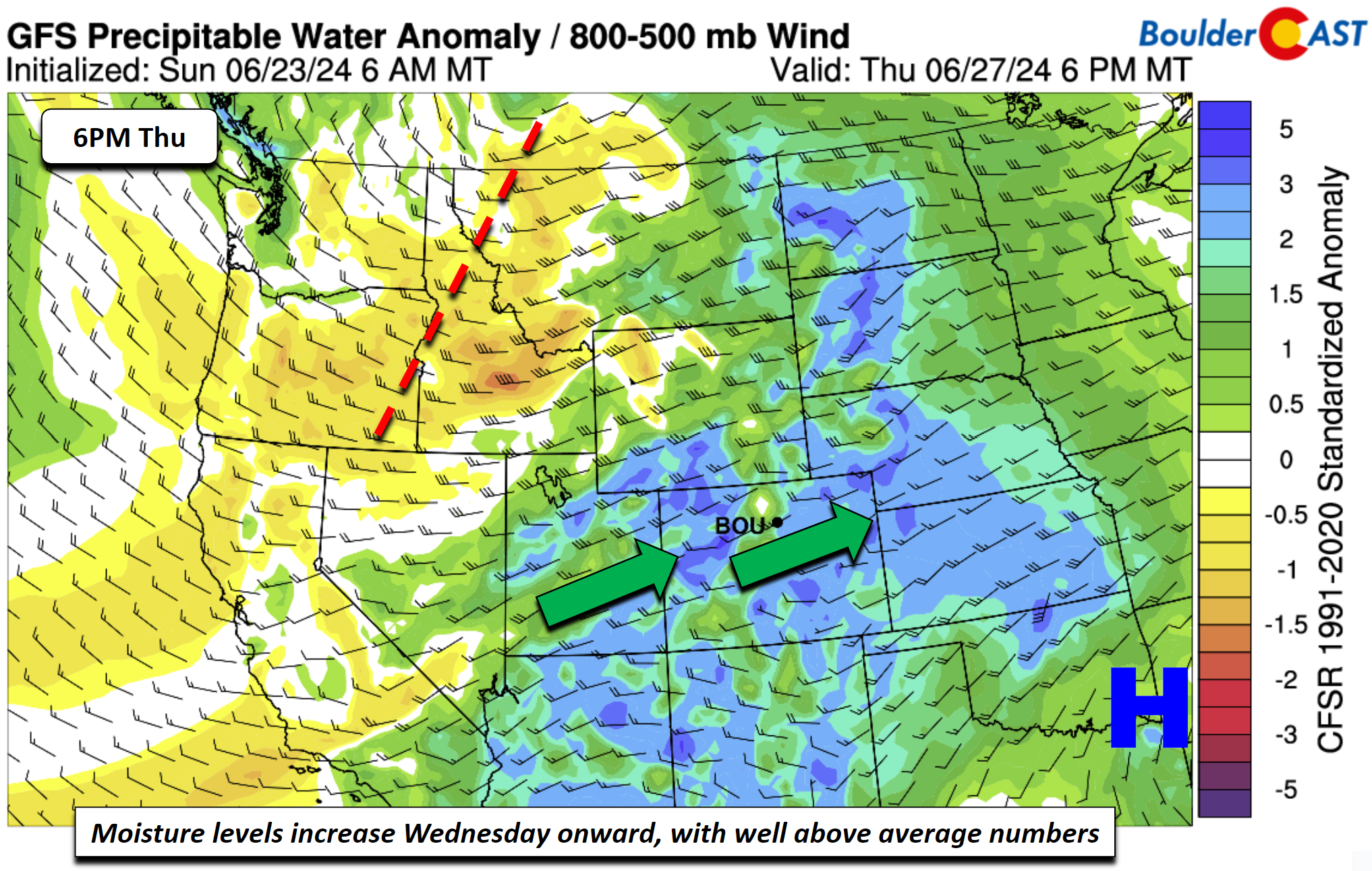
On Thursday, the high will further dislocate itself as the trough to our northwest increases its eastward movement over Montana and Idaho. This will bring a more cyclonic flow and continue to pump in higher moisture to the Front Range, along with lowering heights for an uptick in rain chances. All of this is to say that Wednesday and Thursday look wetter than the beginning of the week. How much rain we will get is unclear, depending on how well storms can maintain themselves as they move east from the High Country and before they intensify across the Eastern Plains. For now, a 30-50% chance appears reasonable for these days. Temperatures trends will oppose the rain chances, with scorching temperatures falling down into the lower 90s by the end of the week with increasing clouds and lowering heights aloft. Yes it will be relatively cooler to end the week, but it will still be warmer than normal.
The mid-level trough will get close enough that it will bring a cold front through sometime Friday night, ushering in finally actual cooler weather, perhaps with temperatures falling into the lower 80s for us on Saturday? That is certainly possible. However, ahead of this potential cooldown, another round of storms will be favored Friday afternoon and evening. Furthermore, shear and instability will be higher, such that we would not be surprised to see the risk of severe storms capable of wind and hail for portions of the Front Range.
Our extended forecast is riddled with 90s, but at least things will be trending wetter and cooler beginning on Wednesday.
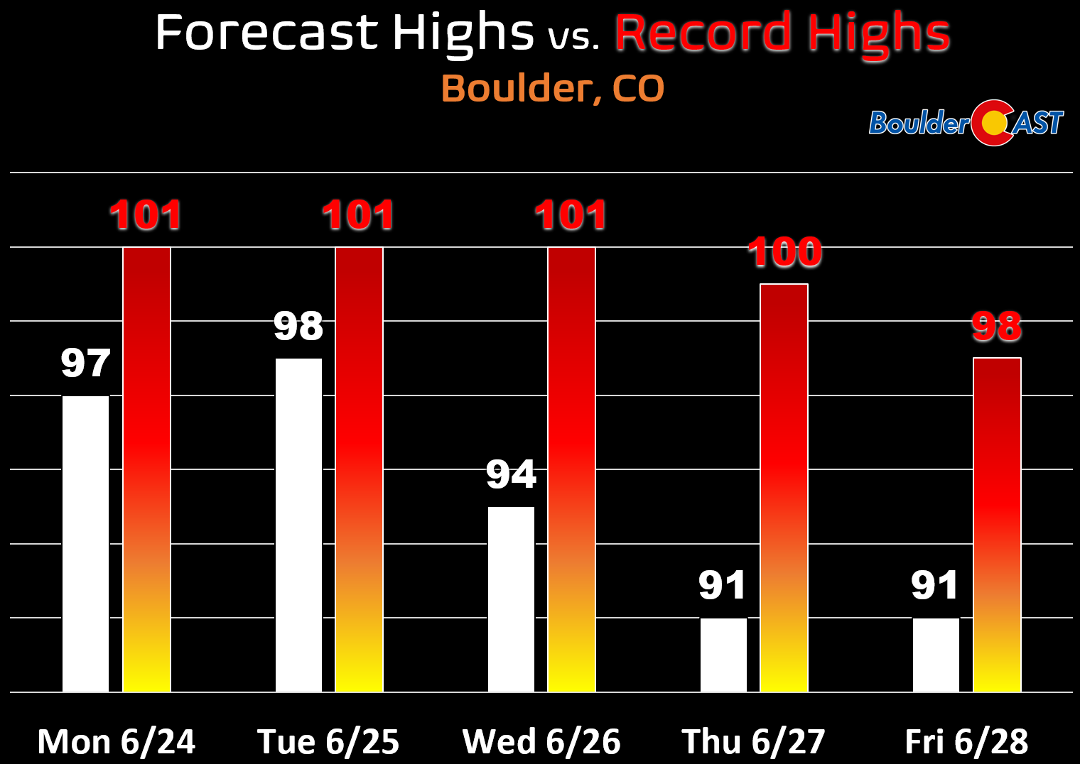
Despite the searing heat this week, for the most part record highs will be off the table as this time of year breaking those requires reaching the triple digits!
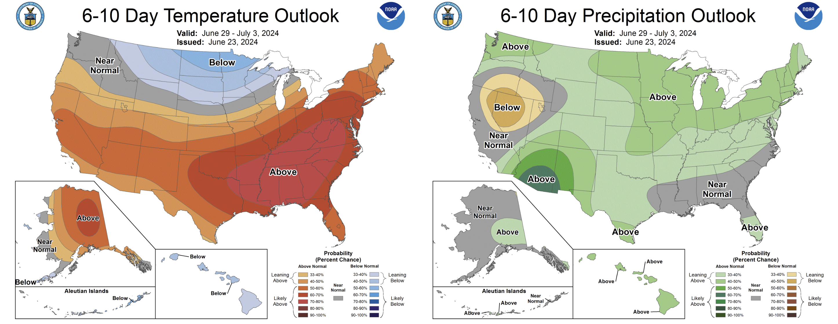
Any relief we get this weekend from the heat will be short-lived, with above normal temperatures favored to return late in the weekend into early next week (more 90s). At least monsoon season appears to be materializing early this year. Parts of southern Arizona will be drenched this week and next with monsoon thunderstorms. We’re hopeful that this monsoon moisture to push into Colorado early in July. Stay tuned!
2023 was the #5 wettest late-spring period in Boulder. 2024 has been the all-time driest… #COWx #Boulderwx https://t.co/1xwHicMMHs pic.twitter.com/DPO9rF0QH9
— BoulderCAST Weather 🏔️❄️ (@BoulderCAST) June 24, 2024
Get BoulderCAST updates delivered to your inbox:
Forecast Specifics:
Monday: Sunny and hot with mid to upper 90s, then increasing clouds with a slight chance of gusty late-day storms. Highs in the Foothills in the middle 80s.
Tuesday: A very slight chance of an isolated PM storm. Otherwise, dry and hot with mid to upper 90s on the Plains and middle 80s in the Foothills.
Wednesday: Sun early, then partly to mostly cloudy with scattered to numerous afternoon and evening thunderstorms. Highs in the low to mid 90s for the Plains and lower 80s in the Foothills.
Thursday and Friday: Partly to mostly cloudy with widely scattered to numerous afternoon/evening storms. Highs in the lower 90s for the Plains and near 80 in the Foothills. A few storms on Friday could produce severe wind and hail.
DISCLAIMER: This weekly outlook forecast is created Monday morning and covers the entire upcoming week. Accuracy will decrease as the week progresses as this post is NOT updated. To receive daily updated forecasts from our team, among many other perks, subscribe to BoulderCAST Premium.
Go Premium, get all the perks.
Daily Forecast Updates
Get our daily forecast discussion every morning delivered to your inbox.
All Our Model Data
Access to all our Colorado-centric high-resolution weather model graphics. Seriously — every one!
Ski & Hiking Forecasts
6-day forecasts for all the Colorado ski resorts, plus more than 120 hiking trails, including every 14er.
Smoke Forecasts
Wildfire smoke concentration predictions up to 72 hours into the future.
Exclusive Content
Weekend outlooks every Thursday, bonus storm updates, historical data and much more!
No Advertisements
Enjoy ad-free viewing on the entire site.
Enjoy our content? Give it a share!


You must be logged in to post a comment.