Whether you like it or not, Front Range Colorado has finally turned a corner on the cool and soggy weather lingering across the area the last few months — just in time for the first day of summer on Wednesday! While the week ahead will offer a few chances for rain, and even some severe storms at times, the overall trend heading into the end of June will be towards drier and hotter weather. Let’s take a look!
This week’s highlights include:
- Another dry and warm day will unfold Tuesday under high pressure aloft
- A surge of moisture from the southeast will fuel the risk of severe thunderstorms Wednesday and Thursday for eastern Colorado with large hail and damaging winds
- The best chance of storms for the Metro area this week comes on Thursday as temperatures fall back into the 70s for highs
- A dry and warm pattern takes hold Friday and beyond with high 80s to 90s expected alongside minimal rainfall chances
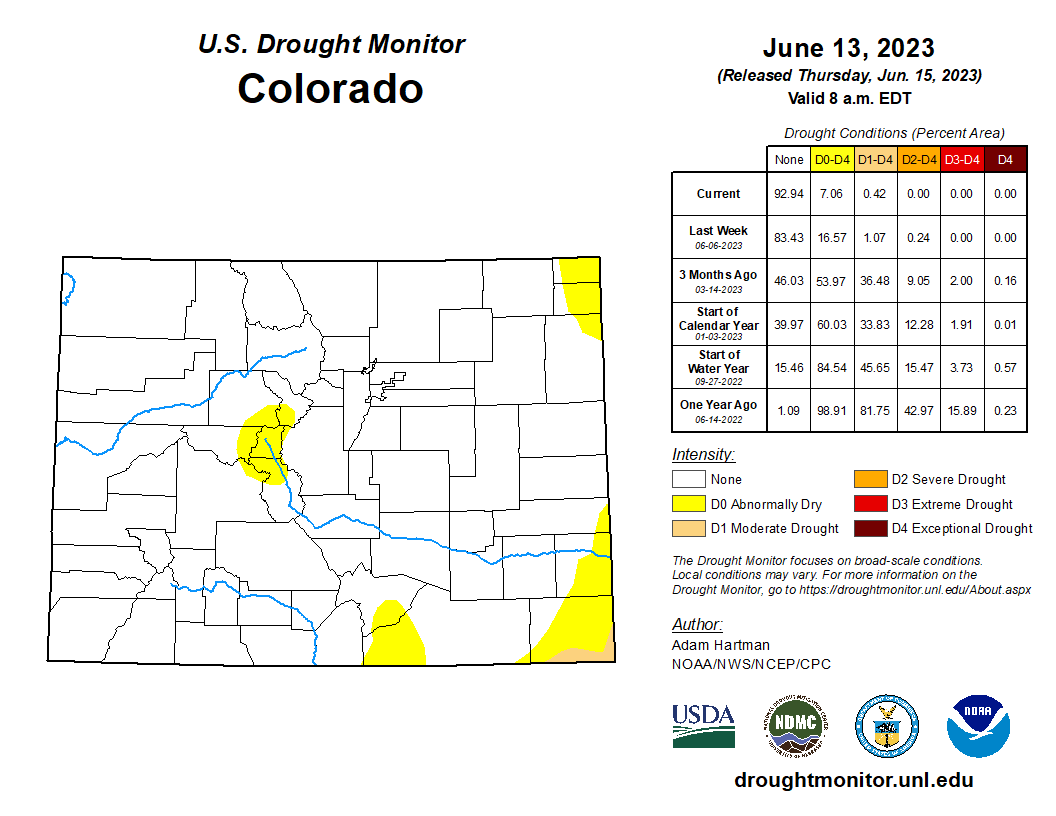
- Despite the dry long-range outlook, Colorado remains in great shape with plenty of lingering mountain snowpack and basically no drought statewide
DISCLAIMER: This weekly outlook forecast is created Monday morning and covers the entire upcoming week. Accuracy will decrease as the week progresses as this post is NOT updated. To receive daily updated forecasts from our team, among many other perks, subscribe to BoulderCAST Premium.
Daily Forecast Updates
Get our daily forecast discussion every morning delivered to your inbox.
All Our Model Data
Access to all our Colorado-centric high-resolution weather model graphics. Seriously — every one!
Ski & Hiking Forecasts
6-day forecasts for all the Colorado ski resorts, plus more than 120 hiking trails, including every 14er.
Smoke Forecasts
Wildfire smoke concentration predictions up to 72 hours into the future.
Exclusive Content
Weekend outlooks every Thursday, bonus storm updates, historical data and much more!
No Advertisements
Enjoy ad-free viewing on the entire site.
One more dry day Tuesday
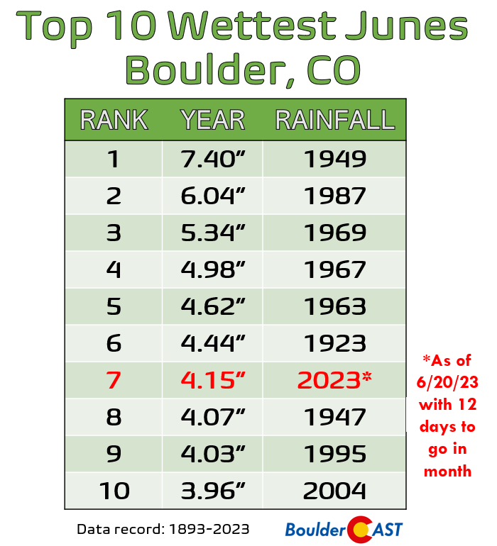
After weeks and weeks of below normal temperatures and constant rain, we’ve had an early taste of summer the last few days with weather more typical for June unfolding across the Front Range. Monday was the hottest day yet in 2023 for the entire area, with many cities hitting 90 degrees for the first time since September and with Boulder getting close but (as expected) coming up just shy. These last few days starkly contrast the prior weeks which were downright soggy. In fact, Boulder has already pushed into the Top 10 Wettest Junes with 12 days still to go this month!
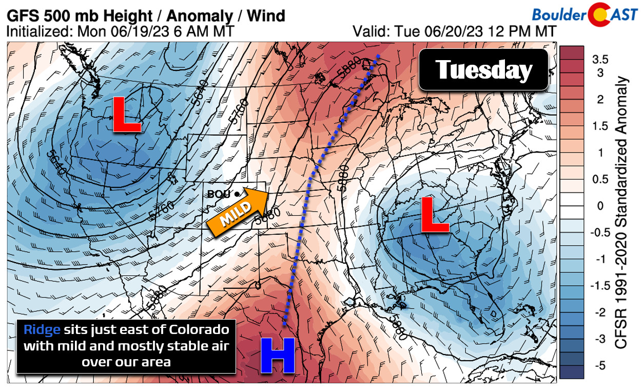
Though the week ahead will see some rainfall potential, it won’t be nearly as drenching as recent times! The large-scale pattern across North America right now is another highly meridional one with a ridge in the middle of the country flanked by troughs on either side— an atmospheric configuration that is definitively stagnant. It truly has been remarkable how much of a slog it has been for weather-wise these last couple months in the US. This week looks to continue the trend, at least in respect to sluggish weather patterns.
With this ridge in place Tuesday, there won’t be enough moisture to overcome the warm air aloft putting a solid cap on our storm chances. Thus, Colorado will see another dry day — something that sure has been hard to come by in recent weeks! There will be more clouds around than prior days, especially in the morning, which should lend to a few degrees of cooling. Highs will fall back into the middle 80s for Tuesday.
Midweek: Rain chances go up, temperatures go down
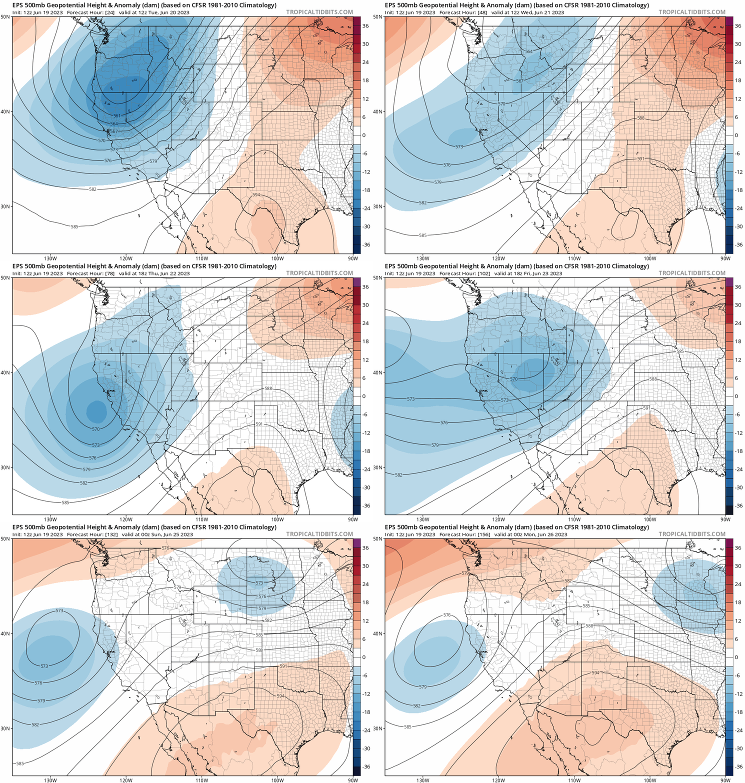
As we head through the rest of the week, the ridge across the center of the country will more or less remain unchanged, while the trough in the Pacific Northwest weakens and reorganizes its energy closer towards Colorado. Still there is strong support from ensemble guidance that this western trough will never fully reach our area before shooting off into the Dakotas. With this, we are expecting a taste of cooler temperatures and wet weather as the week progresses with weak disturbances clipping the area, but this trough won’t entirely reach Colorado even in the extended.
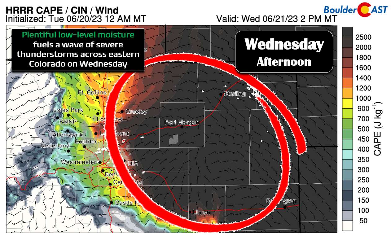
Look for highs to drop further into the lower 80s on Wednesday. Conditions appear favorable for severe weather Wednesday afternoon and evening across eastern Colorado. There will be over 1500 J/kg of CAPE (instability) and some shear to work with (but not a lot).
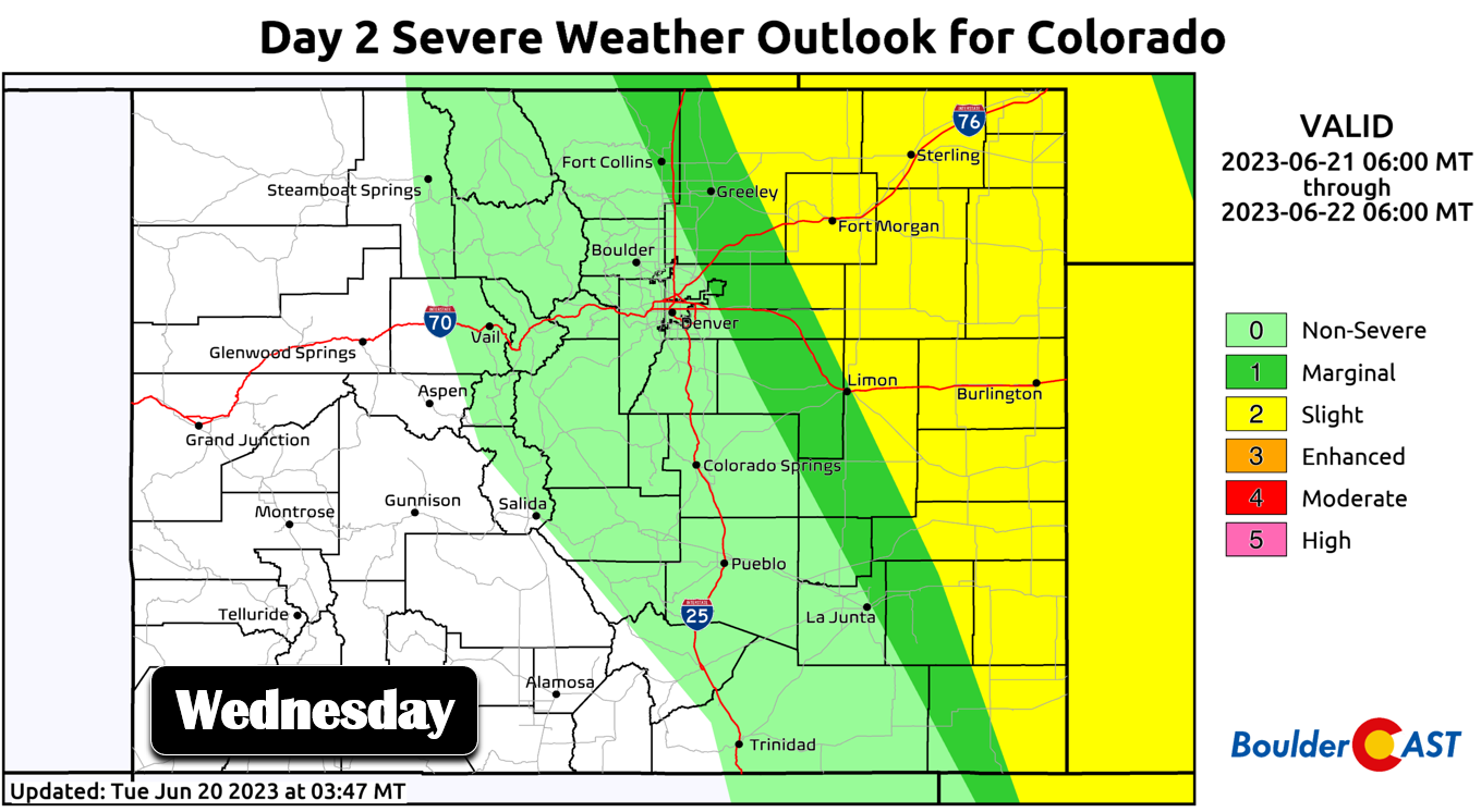
The Storm Prediction Center currently includes portions of the Metro area at Marginal Risk for severe storms on Wednesday, mainly east of Interstate 25. The risk closer to Nebraska and Kansas will be even higher. The main concerns are for hail up to 2″ in diameter and 65 MPH wind gusts, with a few tornadoes possible as well. Boulder and Denver both currently sit outside the risk area, but this could possibly change as the moisture boundary at the surface draped over the region could shift slightly further west bringing the risk of severe storms to our area as well. Storm coverage for us on Wednesday will be scattered, but the storms that do form could be on the strong to severe side with the chance lingering into the late evening or overnight hours.
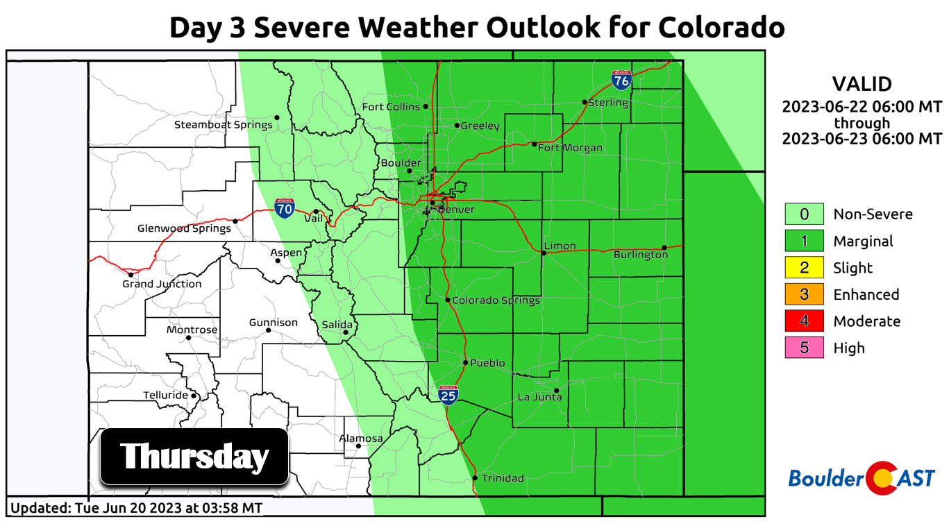
Wednesday night a frontal boundary of sorts will push into eastern Colorado and lead to potential low clouds for Thursday morning. This front will juice up low-level moisture and provide a bit of stronger southeasterly upslope bringing our best chance of rain for the week on Thursday, some of which could be in the form of severe thunderstorms. There is still some uncertainty in how exactly low-level moisture will be distributed on Thursday and how much sunshine there will be the cook the storms. However, at the moment Thursday looks like an active day with fairly numerous thunderstorms developing in the afternoon with the chance continuing into the late evening or overnight. Storms may produce large hail.
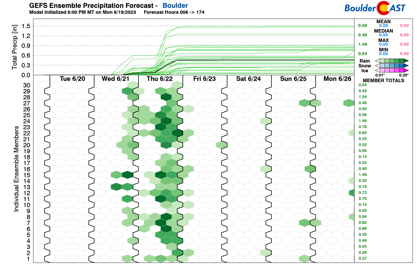
As mentioned, Thursday will offer the best chance of rain this week. This is shown well by the thirty GFS ensemble members below. Anywhere from 0.25 to 0.75″ of rain is expected by Thursday night, but with some higher and lower totals possible in some areas due to the convective and spotty nature of the storms.
Things dry out by Friday with temperatures returning to the middle to upper 80s across the Front Range. There will likely be a continued even worse risk of severe weather in the far northeast corner of the state, but the Front Range should stay in the clear. The upcoming weekend looks stellar with plentiful sunshine and seasonal temperatures mostly in the middle to upper 80s.
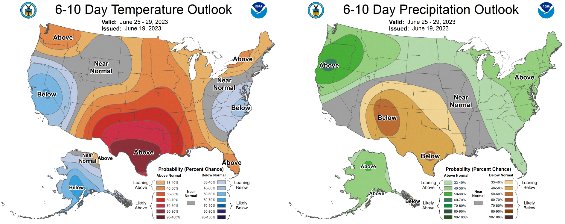
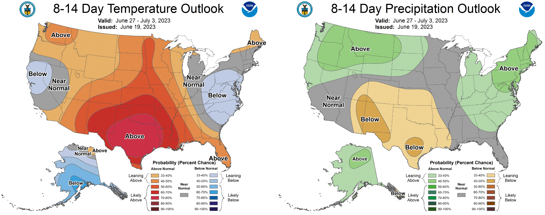
Based on long-range modeling, it does appear that we have finally turned a corner on the cool/wet pattern which has been a theme here in Colorado this spring. We knew it couldn’t be this cool/wet for much longer! The CPC indicates elevated chances for hot and dry weather in both their 6-10-day and 8-14-day outlooks for our area:
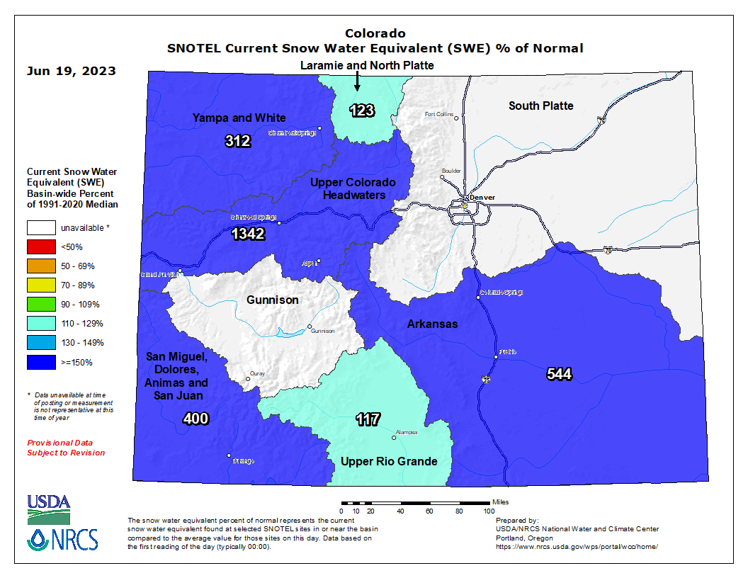
This drying out is totally normal for this time of year in the Front Range — it’s just happening a bit late this year. It won’t be long before the monsoon kicks in hopefully by the first or second week of July. Despite the dry outlook, Colorado is in a superb place right now with plenty of lingering snowpack and less than 0.5% drought coverage!
Interesting to see the native prairie just as green as the irrigated farmland coming into DIA… #COwx pic.twitter.com/8xKJ1P7Tun
— BoulderCAST Weather (@BoulderCAST) June 20, 2023
Forecast Specifics:
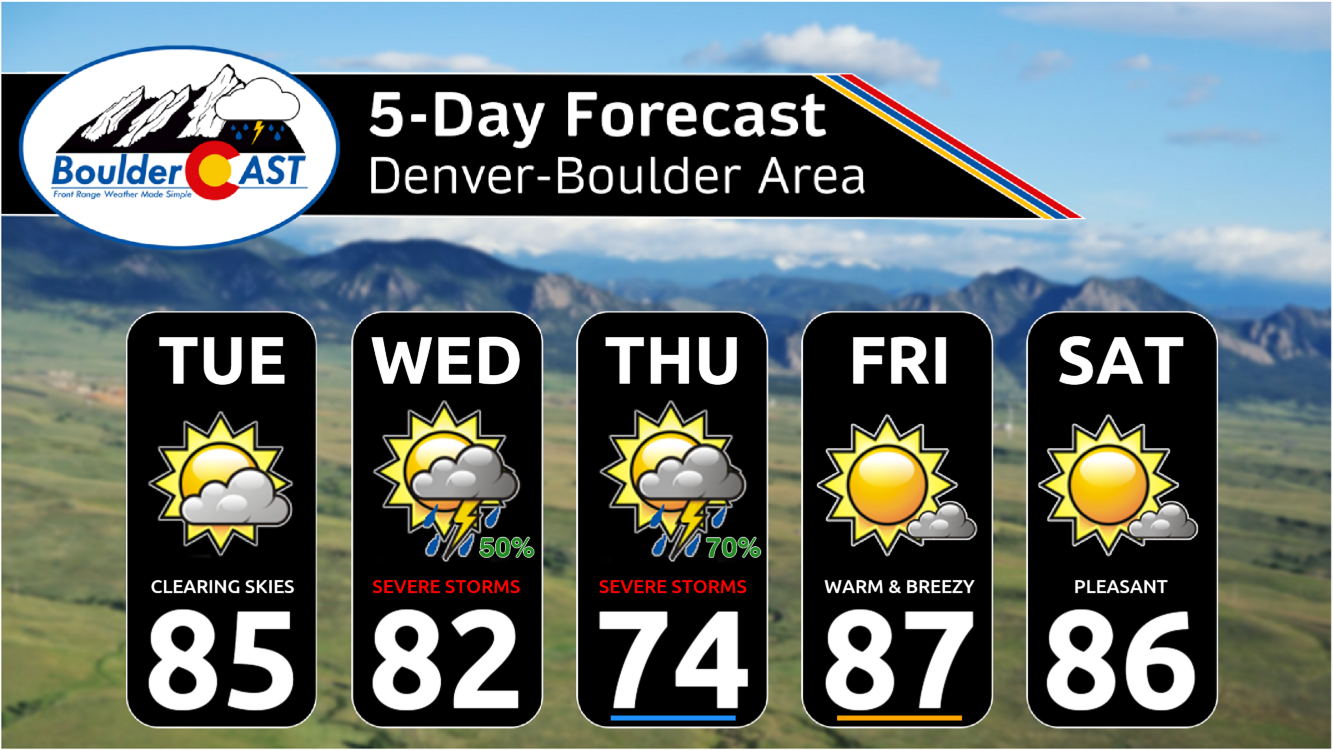
Tuesday: Mostly cloudy in the morning, then mostly sunny with highs in the middle 80s across the Plains and lower 70s in the Foothills. No chance of rain.
Wednesday: Morning sun, then partly cloudy with scattered thunderstorms during the afternoon and evening. Storms could turn severe with very large 2″ hail, damaging winds, and tornadoes. Highs around seasonal values in the lower 80s for the Plains with upper 60s in the Foothills.
Thursday: Possibly some morning low clouds, then partly cloudy, cooler and stormier with numerous to widespread showers and storms developing during the afternoon, evening, and early overnight. Storms will be capable of producing large hail. Temperatures only reach the middle 70s on the Plains with upper 60s in the Foothills.
Friday: Mostly sunny and warm with highs in the mid to upper 80s on the Plains with lower 70s in the Foothills. There could be a few isolated storms but these should remain well north and northeast of Denver.
Saturday: Mostly sunny with just a few late-day clouds. High temperatures in the middle to upper 80s on the Plains with lower 70s in the Foothills.
DISCLAIMER: This weekly outlook forecast is created Monday morning and covers the entire upcoming week. Accuracy will decrease as the week progresses as this post is NOT updated. To receive daily updated forecasts from our team, among many other perks, subscribe to BoulderCAST Premium.
Daily Forecast Updates
Get our daily forecast discussion every morning delivered to your inbox.
All Our Model Data
Access to all our Colorado-centric high-resolution weather model graphics. Seriously — every one!
Ski & Hiking Forecasts
6-day forecasts for all the Colorado ski resorts, plus more than 120 hiking trails, including every 14er.
Smoke Forecasts
Wildfire smoke concentration predictions up to 72 hours into the future.
Exclusive Content
Weekend outlooks every Thursday, bonus storm updates, historical data and much more!
No Advertisements
Enjoy ad-free viewing on the entire site.
Get BoulderCAST updates delivered to your inbox:
Enjoy our content? Give it a share!





You must be logged in to post a comment.