Record-breaking temperatures will be the story this week in the Front Range, though there’s plenty more to discuss. While a brief cooldown is on the way Tuesday, it comes with a catch—a chance for severe storms, depending on how quickly low clouds clear up. Then, just as we get a break, another scorching heatwave arrives on Thursday through the upcoming weekend, with several days of triple-digit temperatures that will shatter records. Let’s dive into the details.
This week’s highlights include:
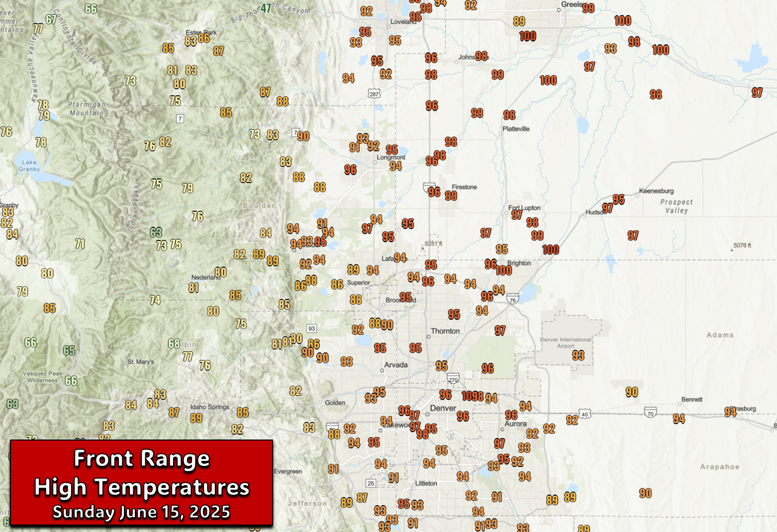
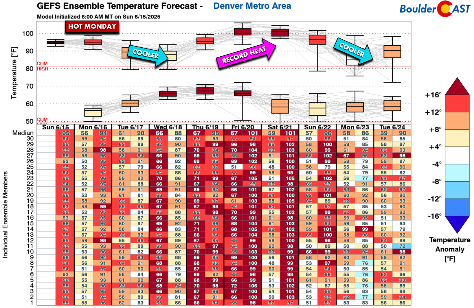
- First HOT days of 2025: Hot weather hit the Front Range over the weekend, with temperatures exceeding 90°F across the lower elevations and reaching 100°F near Greeley and Brighton on Sunday.
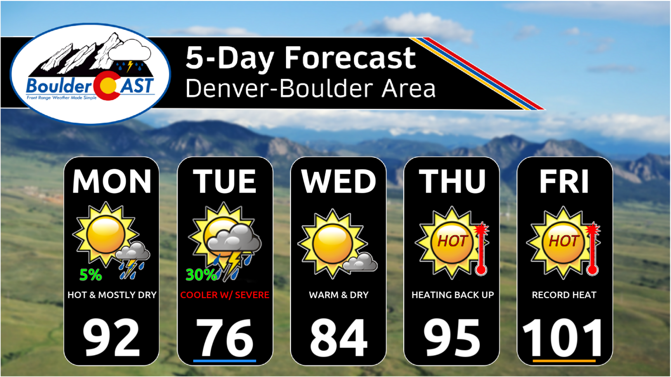
- A short-lived welcomed cooldown is expected Tuesday as a Pacific Northwest disturbance disrupts the high-pressure system, bringing a cold front and a chance of scattered thunderstorms.
- Severe storm potential Tuesday hinges on cloud cover; if clouds clear quickly, the Denver area could see strong storms with hail and damaging winds. If clouds linger too long, we may miss out on most of the rain and stay chilly.
- Significant heat wave begins Thursday, with temperatures soaring back into the 90s and low 100s. Record highs are extremely likely Friday and Saturday.
- Next week may bring relief, as a Pacific trough moves in, possibly cooling temperatures into the 80s for a day or two.
DISCLAIMER: This weekly outlook forecast is created Monday morning and covers the entire upcoming week. Accuracy will decrease as the week progresses as this post is NOT updated. To receive daily updated forecasts from our team, among many other perks, subscribe to BoulderCAST Premium.

Go Premium, get all the perks.
Daily Forecast Updates
Get our daily forecast discussion every morning delivered to your inbox.
All Our Model Data
Access to all our Colorado-centric high-resolution weather model graphics. Seriously — every one!
Ski & Hiking Forecasts
6-day forecasts for all the Colorado ski resorts, plus more than 120 hiking trails, including every 14er.
Smoke Forecasts
Wildfire smoke concentration predictions up to 72 hours into the future.
Exclusive Content
Weekend outlooks every Thursday, bonus storm updates, historical data and much more!
No Advertisements
Enjoy ad-free viewing on the entire site.
Heatwave #1 ends on Monday
Sunday saw high temperatures soar to their hottest values yet in 2025 across the Front Range, with nearly the entire lower elevations eclipsing 90 degrees, with a few spots even reaching the 100-degree mark near Greeley and Brighton.
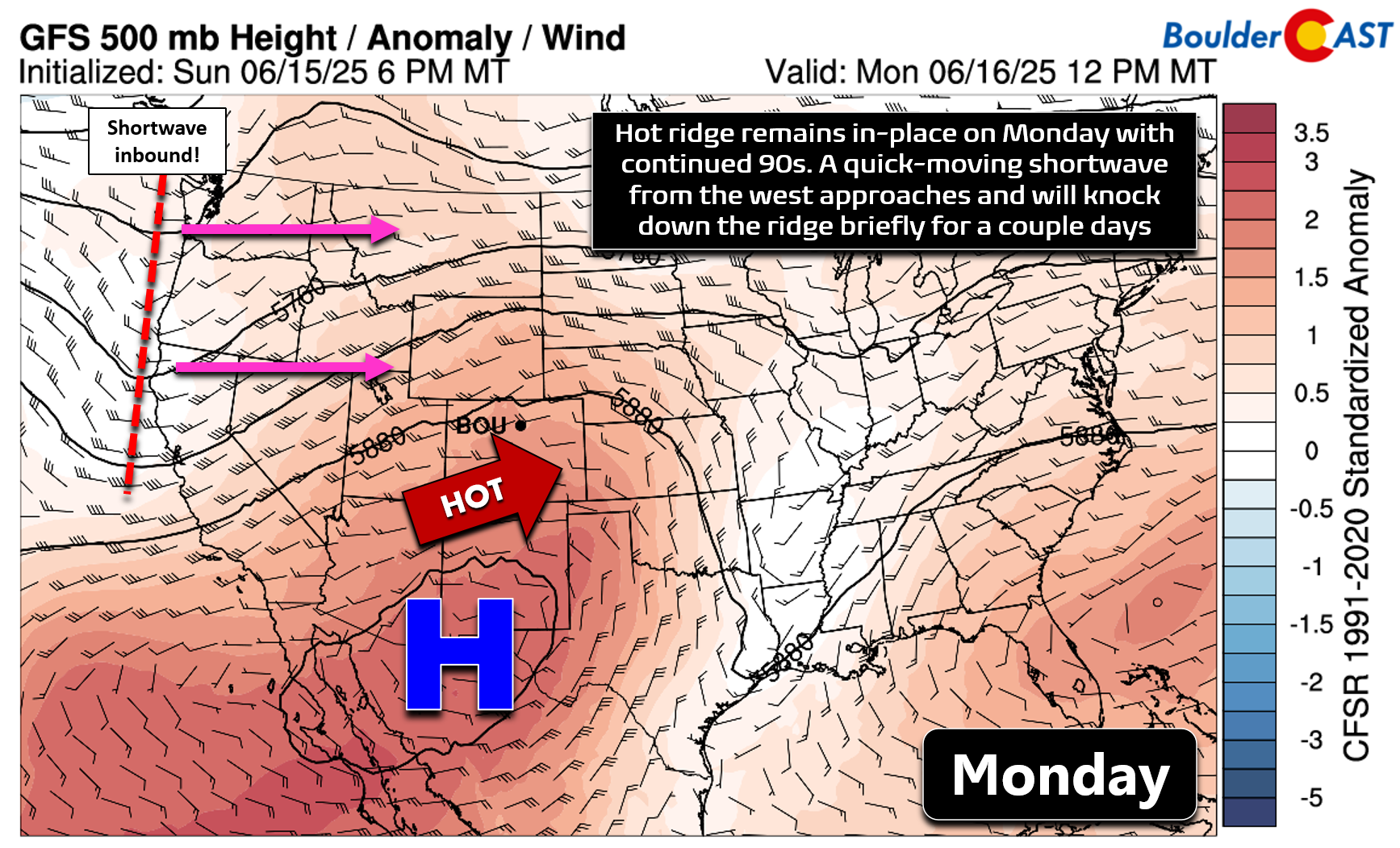
With little change noted in the overall pattern, Monday will see continued heat as strong high pressure sits across the southwestern United States facilitating hot and dry southwesterly flow into Colorado. A shortwave disturbance entering the Pacific Northwest will be a player for us the next few days — more on that feature in a moment.
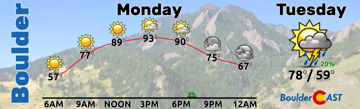
Monday will see continued hot temperatures reaching the low to middle 90s across the Boulder-Denver area. Morning sunshine will transition to partly cloudy skies through the afternoon with a slight chance of a late-day thundershower (5-10%). More than a sprinkle will be hard to come by on Monday with dew points in the 20s to 30s at best!
Brief cooldown Tuesday with uncertain severe risk
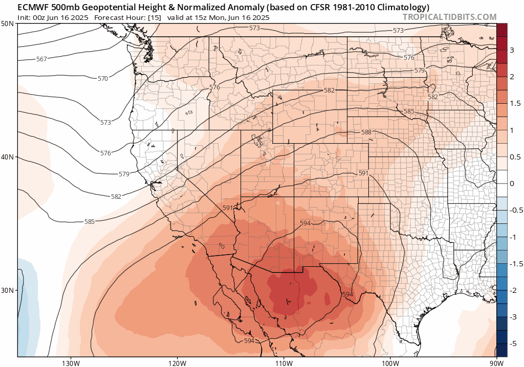
Beginning Monday night, we will start to see tides of change across Colorado as the aforementioned Pacific Northwest disturbance races eastward through the area. Despite its small stature, models continue to show this feature knocking down the strong ridge for a couple days, giving us a temporary reprieve from the heat. The Euro model’s 500mb height anomaly forecast animation below shows the broader pattern from Monday morning through early Wednesday. Notice how the ridge gets shunted south as the small wave passes.
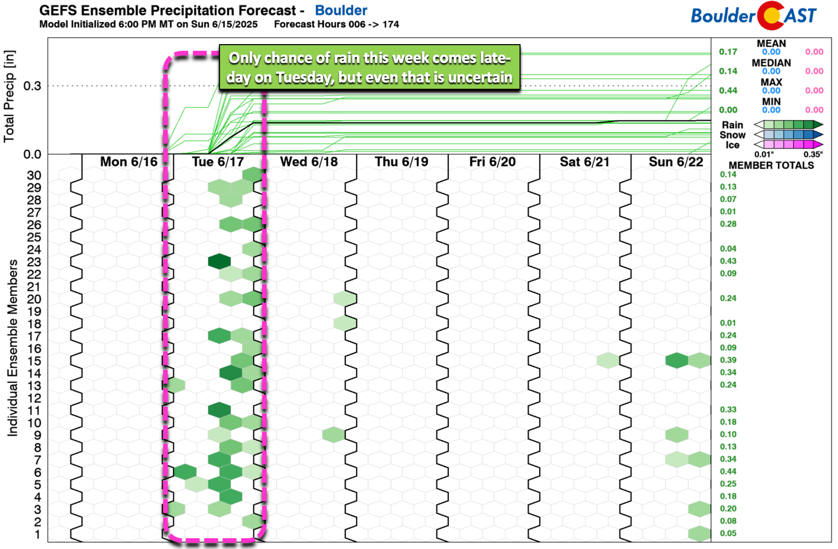
This atmospheric beatdown will lead to cooler weather and our only real chance of rain for the week — two things that we could use a little more of right now but sadly have little hope to obtain.
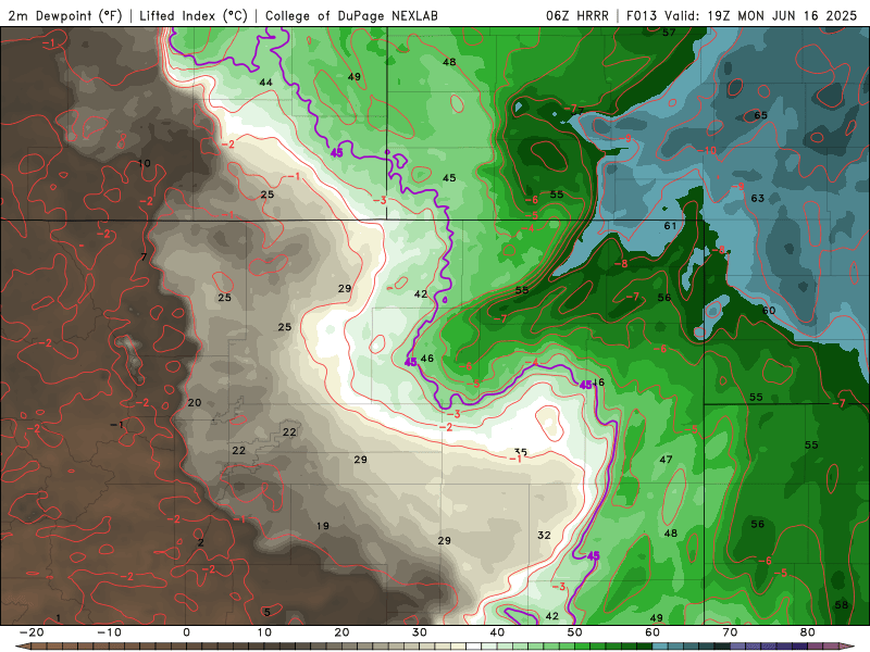
Change begins Monday night as a cold front, enhanced by outflow from severe storms in the far northeast corner of the state, races in across the lower elevations. One way to visualize this frontal boundary pushing in Monday night is through a high-resolution forecast animation of dew points (below). After enduring a very hot and dry day on Monday, the frontal surge Monday night will bring much cooler and moisture-rich air into the Metro area from the northeast around midnight or so, with dew points jumping into the 50s.
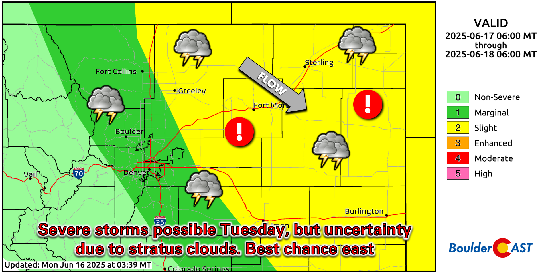
While we probably won’t see any showers or storms with the frontal passage itself, though some models do try to spawn some thunderstorms in the middle of the night, this moisture will set the stage for potential severe storms to develop on Tuesday. As usual, this type of setup will be a tricky one to predict here. Widespread low clouds will form through the night behind the front, with those clouds then having to burn off on Tuesday to fuel our storms. Models and forecasters alike notoriously struggle with this setup, so right now we’re not 100% sure how things will go on Tuesday here. There are really three potential outcomes we see:
- Clouds Hold On Most of the Day: If clouds are more stubborn to dissipate on Tuesday, we may entirely miss out on the rainfall chance with highs only in the 60s.
- Clouds Clear Quickly: If the clouds clear out quickly, this will bring forth a good chance of severe thunderstorms in the Metro area and highs around 80 degrees. Storms would contain large hail and damaging winds, as storms will be capable of tapping into deep shear.
- Clouds Clear But Slowly: If the clouds are slower to clear out, this would allow for some showers and storms and highs in the 70s. Most of the severe weather may end up to our east, but we could still get some tamer storms here.
Outcome #3 is currently the way we are leaning, with highs in the the 70s and a chance of scattered thunderstorms Tuesday afternoon and early evening. There could be some severe storms here, but the greatest risk will be just east of the Denver area. The latest run of the HRRR model shows afternoon supercells consolidating Tuesday evening into a line of storms heading towards Kansas with a likely straight-line wind risk.
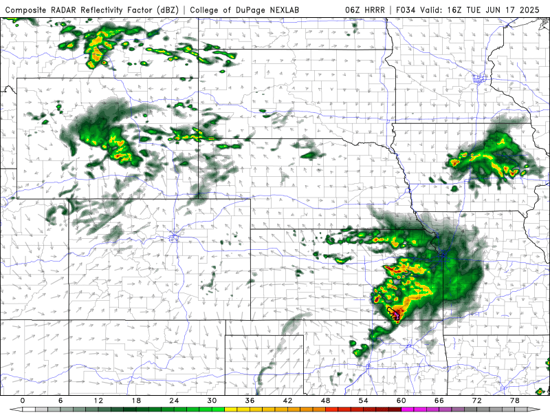
There could be some strong to severe storms in our immediately area on Tuesday, but the greatest risk will be east of Denver where low clouds would clear our earlier in the day and allow for better heating. The Storm Prediction Center currently has our entire area at Marginal Risk for severe storms, and given the uncertainty in the burn off time of the clouds, definitely stay weather aware on Tuesday!
After the busy day of weather on Tuesday, we’ll dry out and warm back up on Wednesday with sunny skies and highs in the low to middle 80s.
Heatwave #2 begins Thursday & brings triple digits
The latter part of the week will see scorching weather return to the Front Range as the ridge re-establishes control of the area. Hot southwest flow, devoid of any real moisture, will surge into the area beginning Thursday with highs in the 90s or better lingering through the upcoming weekend.
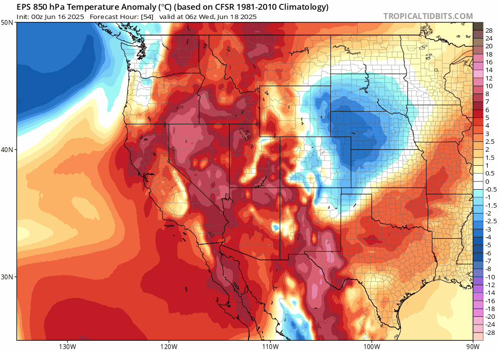
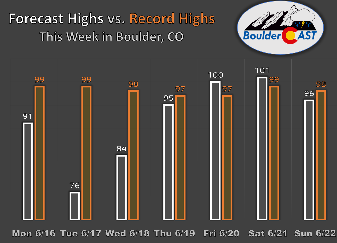
In fact, model guidance is very strongly suggesting that we’ll be dealing with several days of record heat in the extended. Nearly 100% of ensemble members are predicting record heat Friday and Saturday with high temperatures in the lower 100s across the Boulder-Denver area. The heat brewing later in the week is no joke — make sure you and yours have a plan to stay cool!
This second heat wave should come to an end early next week as a strong trough enters the Pacific Northwest. Still, being a solid week away, it’s not clear exactly how much cooling from this trough would reach northeast Colorado — probably enough to knock us down in the 80s for a day or two early next week, but perhaps not much else. A small chance of storms may return to the forecast late in the weekend as well.
The main two weather concerns this week in Colorado will be the uncertain severe storm risk on Tuesday and the developing late-week scorching heatwave. Stay cool and weather aware!
Forecast Specifics:
Monday: Lots of sun early, then partly cloudy with a tiny risk of a weak thundershower. Highs in the lower 90s on the Plains with lower 80s in the Foothills.
Tuesday: Morning low clouds, then partly cloudy with scattered thunderstorms in the afternoon and early evening. Some storms could turn severe, mainly east of Interstate 25 with large hail and strong winds. Highs much cooler in the 70s on the Plains with 60s in the Foothills.
Wednesday: Mostly sunny, warm and dry — probably the nicest day of the week. Highs reach the low to middle 80s on the Plains with lower 70s in the Foothills.
Thursday: The heat returns with mostly sunny skies and highs in the middle 90s on the Plains and lower 80s in the Foothills.
Friday: Very hot with record highs likely in the lower 100s across the Plains and upper 80s in the Foothills.
Weekend: Staying very hot Saturday in the lower 100s with record highs, trending perhaps slightly cooler on Sunday into the mid to upper 90s with a small chance of rain. Another cooldown is in the works for early next week.
DISCLAIMER: This weekly outlook forecast is created Monday morning and covers the entire upcoming week. Accuracy will decrease as the week progresses as this post is NOT updated. To receive daily updated forecasts from our team, among many other perks, subscribe to BoulderCAST Premium.
Go Premium, get all the perks.
Daily Forecast Updates
Get our daily forecast discussion every morning delivered to your inbox.
All Our Model Data
Access to all our Colorado-centric high-resolution weather model graphics. Seriously — every one!
Ski & Hiking Forecasts
6-day forecasts for all the Colorado ski resorts, plus more than 120 hiking trails, including every 14er.
Smoke Forecasts
Wildfire smoke concentration predictions up to 72 hours into the future.
Exclusive Content
Weekend outlooks every Thursday, bonus storm updates, historical data and much more!
No Advertisements
Enjoy ad-free viewing on the entire site.
Enjoy our content? Give it a share!


You must be logged in to post a comment.