This week in the Front Range will be rather quiet and dry with most of the weather systems passing to our south. High temperatures will largely hover in the 40s throughout the extended — a very seasonal stretch indeed! There is some indication for a late-week snow chance but that is currently shaping up to be very minor at best. Let’s take a look…
This week’s highlights include:
- Quiet weather with pseudo-normal highs in the 40s throughout the week
- Quasi-zonal downslope flow largely ensues most of the week
- A few weather systems will pass to our south with little overall consequence for the Front Range
- We are watching the potential for a cooldown and a chance of snow by week’s end, but any accumulations are expected to be very light

DISCLAIMER: This weekly outlook forecast is created Monday morning and covers the entire upcoming week. Accuracy will decrease as the week progresses as this post is NOT updated. To receive daily updated forecasts from our team, among many other perks, subscribe to BoulderCAST Premium.

Go Premium, get all the perks.
Daily Forecast Updates
Get our daily forecast discussion every morning delivered to your inbox.
All Our Model Data
Access to all our Colorado-centric high-resolution weather model graphics. Seriously — every one!
Ski & Hiking Forecasts
6-day forecasts for all the Colorado ski resorts, plus more than 120 hiking trails, including every 14er.
Smoke Forecasts
Wildfire smoke concentration predictions up to 72 hours into the future.
Exclusive Content
Weekend outlooks every Thursday, bonus storm updates, historical data and much more!
No Advertisements
Enjoy ad-free viewing on the entire site.
Rather benign weather for much of the week
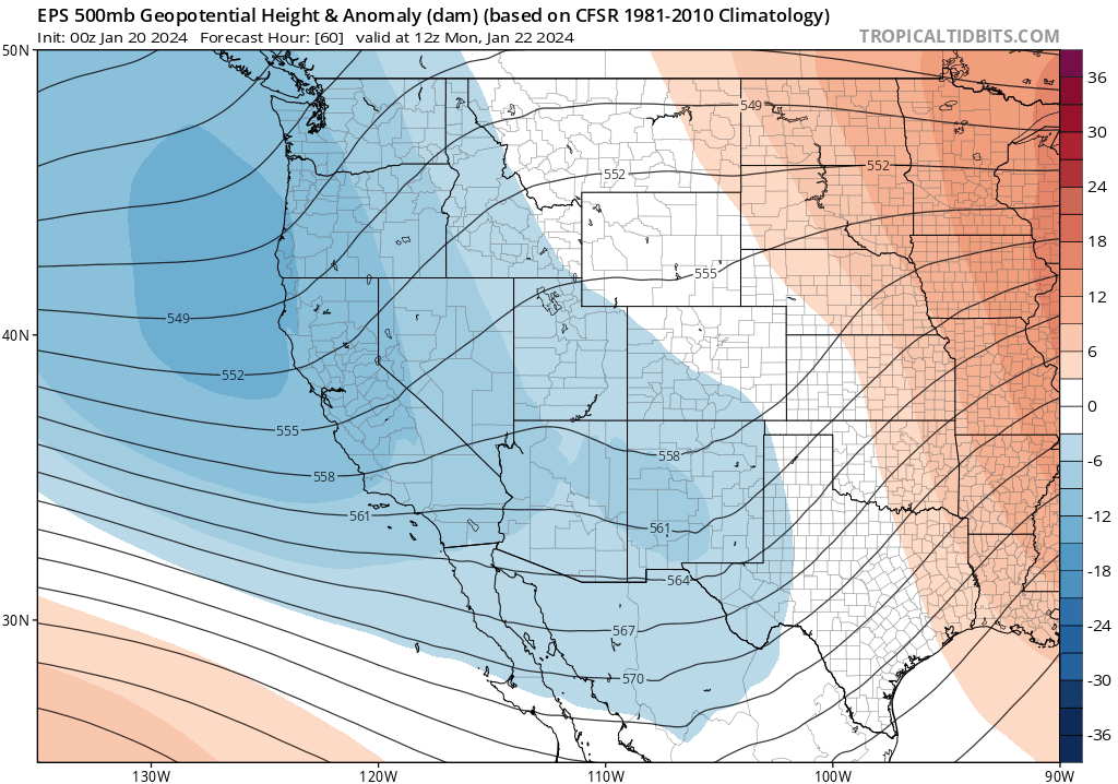
If quiet weather is your cup of tea, then you are in luck for this upcoming work week in Colorado! Below shows the European ensemble mean animation at mid-levels from Monday through Saturday. A few systems, notably today and Wednesday, will pass to our south into Texas and the lower Mississippi valley through the week. To the north of these systems, we will remain in a quasi-zonal pattern with west to southwest flow becoming west-northwest by the tail end of the week. Speaking of that northerly flow by Thursday/Friday, there are some hints that it could bring cooler weather and a snow chance, but we’ll touch on that in a moment — right now that snow chance appears minimal. The overall flow should keep us dry and with seasonal temperatures in the 40s. By late in the weekend, there are indications that a large ridge could engulf our region for a return to the 50s for Sunday or next Monday.
The GEFS ensemble temperature pattern is shown for the week below. Notice how our highs will not stray much from day-to-day with 40s expected through the work week. As mentioned earlier, however, note the greater spread in highs for Friday with a more northerly flow possible — highs that day could vary from the upper 30s to the lower 50s. Finally, also note the return to 50s possible under next week with likely strong ridging aloft moving in.

For Monday, we did mention a southern track system will pass to our south and east into Kansas by evening. While the system is not an overly strong one, it will produce cloud cover from time to time in the Front Range and a light upslope flow from the east and north since we’ll be in a favorable location for this as it tracks eastward. Highs today should be a touch below those on Sunday in the upper 40s.
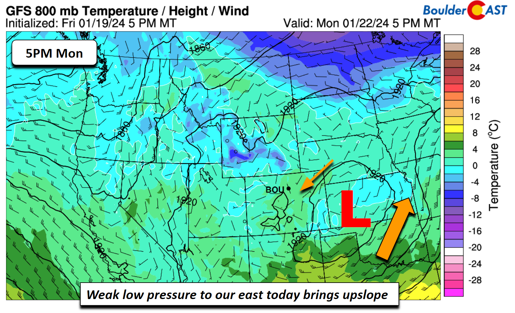
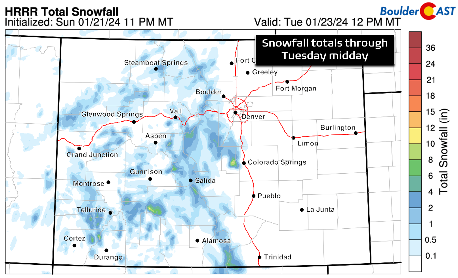
The southern wave is expected to bring some light snow to the Mountains statewide today into the evening. Moisture is limited on the Plains and even surface temperatures are above freezing in the 40s. We don’t see any threat of precipitation for the Denver Metro. All in all, Monday will be dry for us with an occasional milky sky.
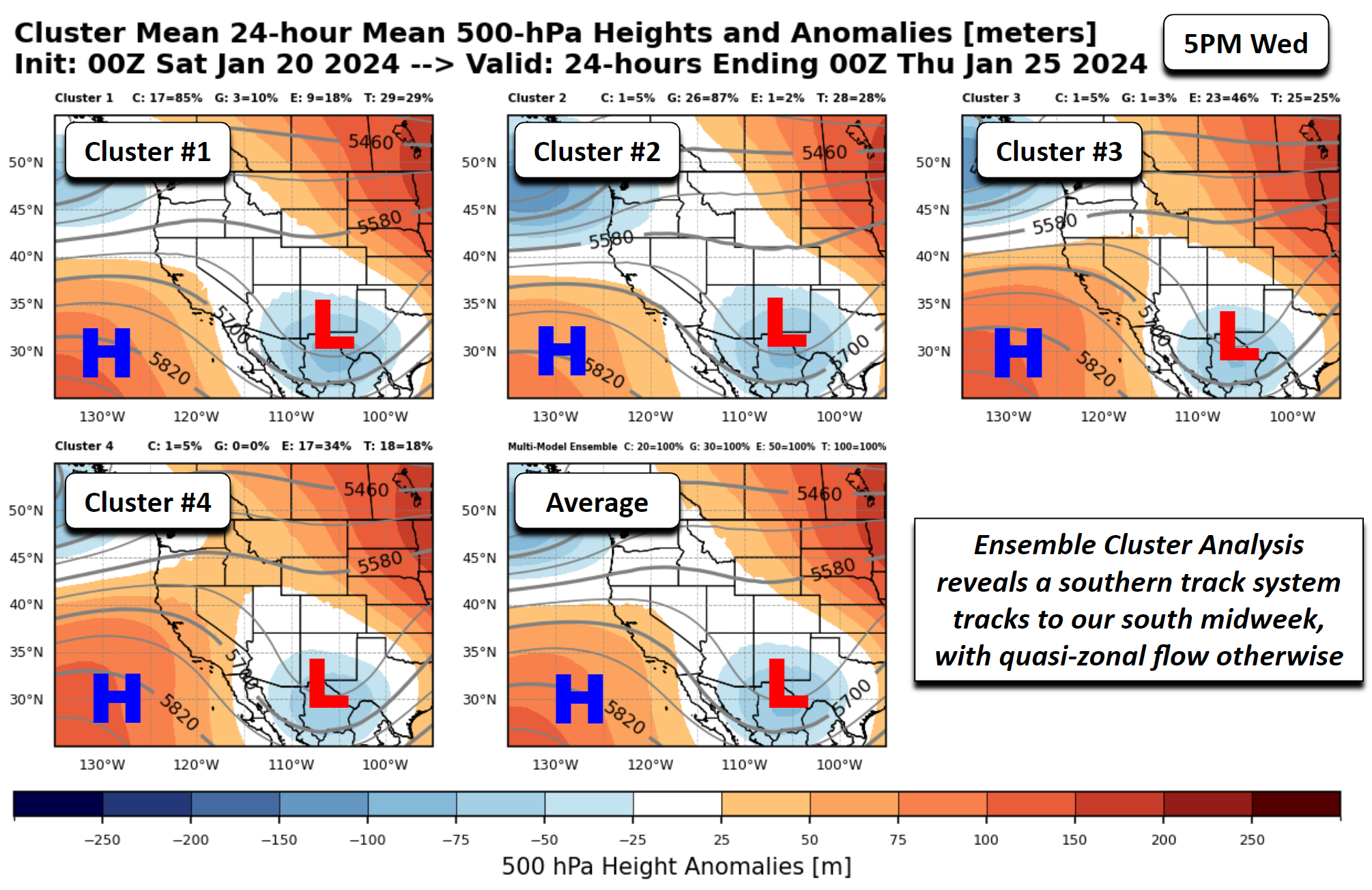
Looking into midweek, another southern track system will reach portions of southern New Mexico and western Texas. The image below is a cluster analysis of 100 ensemble members from the GEFS/EPS/CMC ensembles. The top four cluster solutions do not vary much from each other, showing the system well to our south. Over us, a westerly zonal flow will be in place on Wednesday. That should keep us dry and again in the 40s for temperatures.
By the tail-end of the week, models and their ensembles do show a somewhat more north-northwesterly flow developing at the low to mid-levels, depicted by the GFS 700 mb temperature pattern below. Embedded in this flow may be a weak shortwave that could bring a chance of snow either late Thursday night or Friday. Highs should still hover in the 40s during this time, but could trend closer to the low 40s on Friday under less downslope flow compared to Tuesday through Thursday.

A look at the cluster analysis from the 100-member ensemble shows that the top two solutions favor a more north-northwesterly flow with a third possible weak system moving south from Utah and the Four Corners. The last cluster solution shows a due north flow, albeit weak.
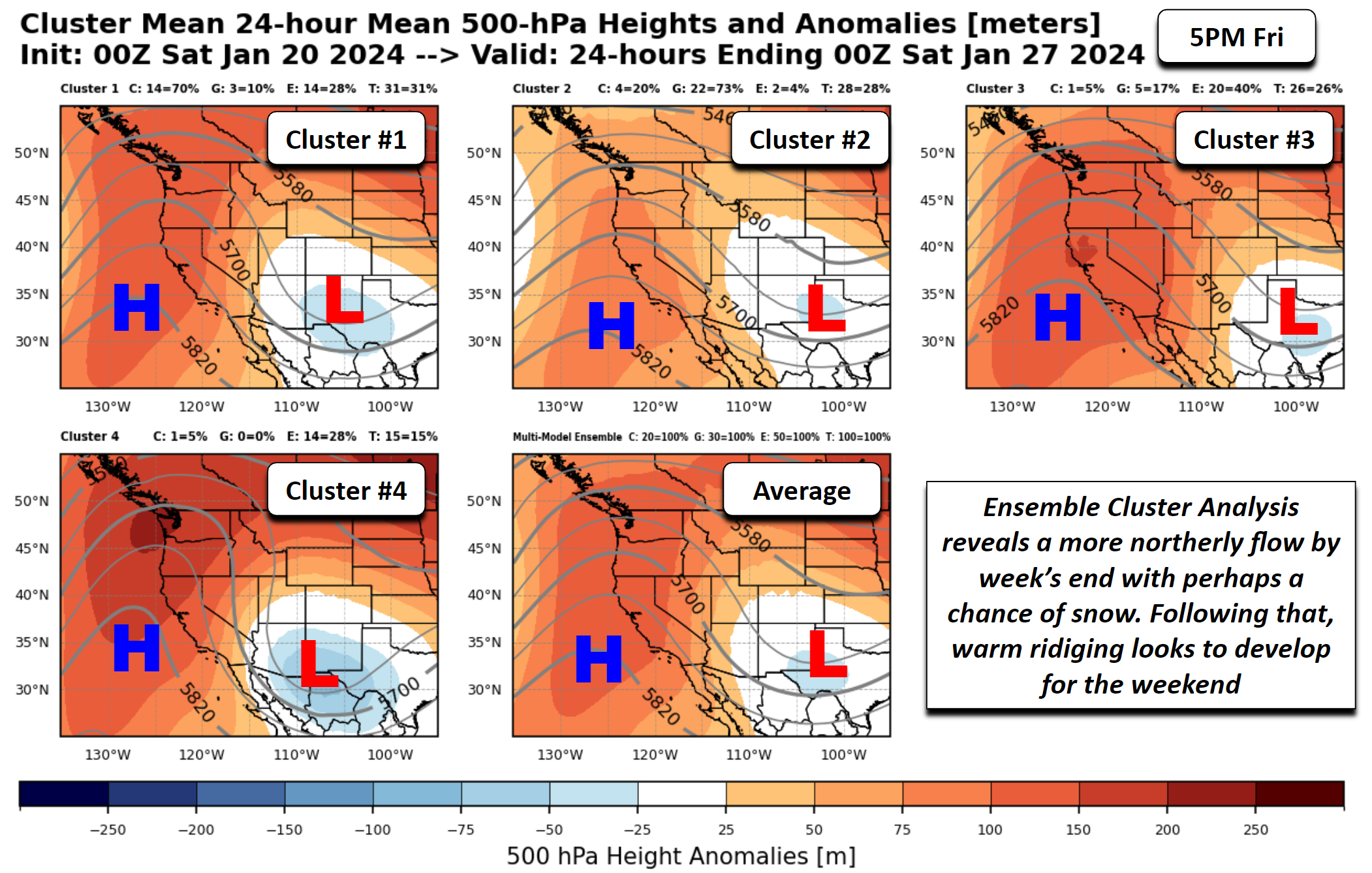
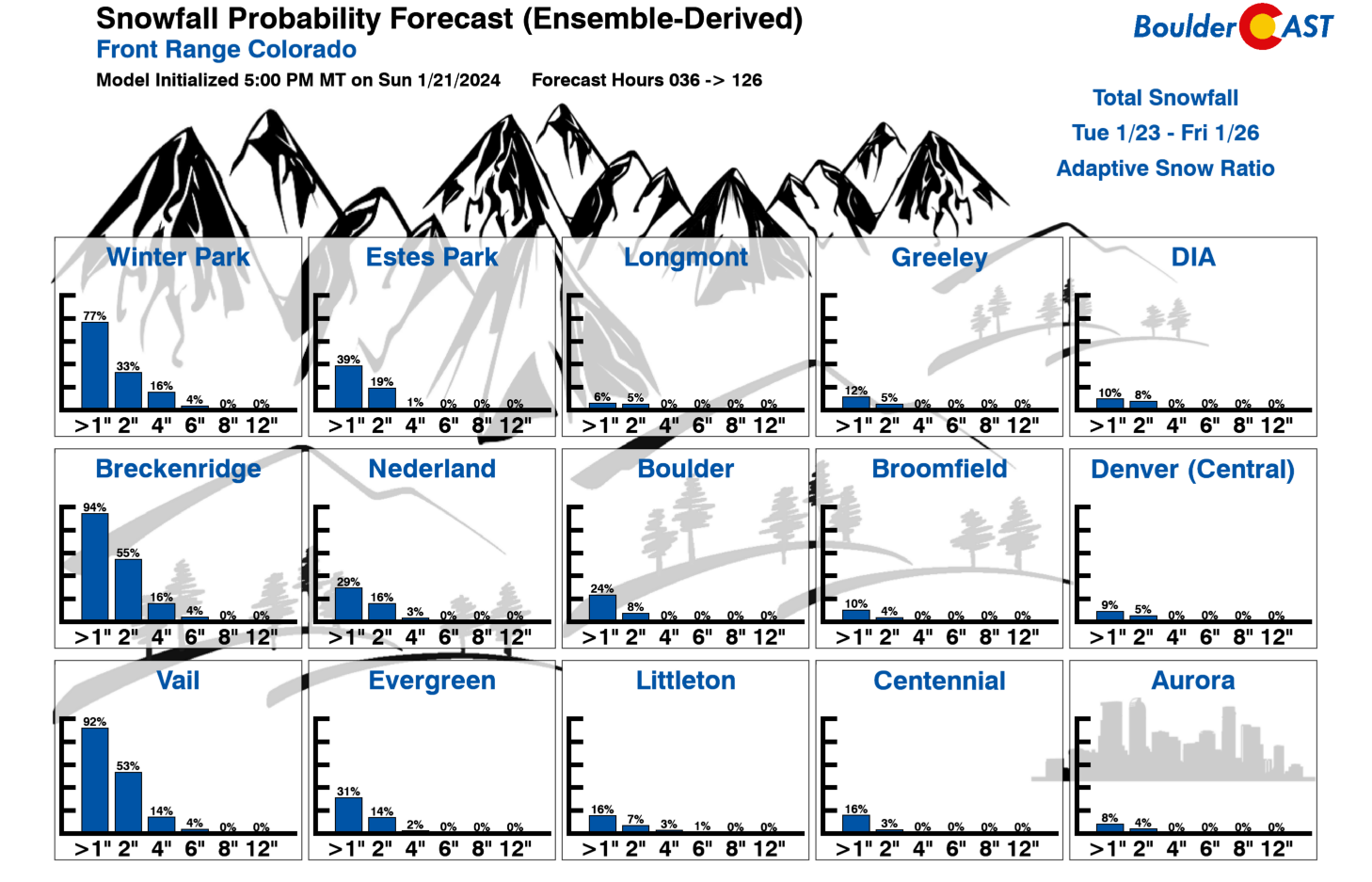
The ensemble mean favors the more northwesterly flow, which could bring some enhanced energy down from Montana/Wyoming and warrant a chance of snow late Thursday or Friday. However, it is difficult to tell at this time. We’ll keep it on the horizon as we get closer, but current indications would favor low-end amounts if any, unless a more potent system can rotate over us from the Four Corners. As it stands now, the main driver for snow would come only from an upslope-centric cold front. As shown in our Snowfall Probabilities below, currently snow amounts less than 1″ are vastly favored for the late-week period.
Enjoy the quiet (and warmer!) weather this week!
Mule deer exploring a mostly snow free hillside 🦌 #cowx pic.twitter.com/PPhVzE3uQn
— BoulderCAST Weather 🏔️❄️ (@BoulderCAST) January 21, 2024
Get BoulderCAST updates delivered to your inbox:
Forecast Specifics:
Monday: A mix of clouds and sunshine. Highs in the upper 40s on the Plains and mid to upper 30s in the Foothills.
Tuesday through Thursday: A mix of some clouds and some sunshine with seasonable temperatures in the mid to upper 40s for the Plains and mid to upper 30s in the Foothills.
Friday: Cooler and overcast with a slight chance of snow. Highs in the lower 40s on the Plains and lower 30s in the Foothills.
DISCLAIMER: This weekly outlook forecast is created Monday morning and covers the entire upcoming week. Accuracy will decrease as the week progresses as this post is NOT updated. To receive daily updated forecasts from our team, among many other perks, subscribe to BoulderCAST Premium.
Go Premium, get all the perks.
Daily Forecast Updates
Get our daily forecast discussion every morning delivered to your inbox.
All Our Model Data
Access to all our Colorado-centric high-resolution weather model graphics. Seriously — every one!
Ski & Hiking Forecasts
6-day forecasts for all the Colorado ski resorts, plus more than 120 hiking trails, including every 14er.
Smoke Forecasts
Wildfire smoke concentration predictions up to 72 hours into the future.
Exclusive Content
Weekend outlooks every Thursday, bonus storm updates, historical data and much more!
No Advertisements
Enjoy ad-free viewing on the entire site.
Enjoy our content? Give it a share!


You must be logged in to post a comment.