We hope you didn’t put your cold weather gear away for the season yet — another Arctic Blast will ooze into eastern Colorado this week! A strong Arctic high will entrench the region in bitter cold air through midweek, with highs during this period well below normal in the teens and 20s with lows in the single digits or slightly below zero. A few weather systems moving through in the westerly flow aloft will bring several chances for snow to the area, but for the most part accumulations will remain relatively light east of the Mountains. Temperatures will moderate by the end of the week and especially the weekend as ridging builds in from the west and the dense Arctic air retreats eastward with surprisingly warm weather not too far off on the horizon.
This week’s highlights include:
- Another Arctic Plunge: A blast of Arctic air builds in again this week lingering for several days. Highs well below normal and coldest Tuesday through Thursday. Overnight lows in the single digits to slightly below zero.
- Light Snow Monday into Tuesday night: Light snow possible Monday and Monday night, with just a trace to 2″ of accumulation for most. A second wave of light snow develops late Tuesday into Tuesday night, with another dusting to 2″ favored.
- Heavy Mountain Snow: Moist Pacific flow will continue to hammer the High Country early to mid-week, with more than a foot of snow possible across the central and northern ranges in Colorado. Skiers will have plenty of fresh powder and Interstate 70 no doubt will be a disaster!
- Snow Again Late Week: Another system approaches Thursday into Friday with plenty of uncertainty, but snow amounts again appear light at this stage.
- Moderating Temperatures: Warmer weather is expected to return late-week into the weekend, with several days in a row of 50s and 60s
DISCLAIMER: This weekly outlook forecast is created Monday morning and covers the entire upcoming week. Accuracy will decrease as the week progresses as this post is NOT updated. To receive daily updated forecasts from our team, among many other perks, subscribe to BoulderCAST Premium.

Go Premium, get all the perks.
Daily Forecast Updates
Get our daily forecast discussion every morning delivered to your inbox.
All Our Model Data
Access to all our Colorado-centric high-resolution weather model graphics. Seriously — every one!
Ski & Hiking Forecasts
6-day forecasts for all the Colorado ski resorts, plus more than 120 hiking trails, including every 14er.
Smoke Forecasts
Wildfire smoke concentration predictions up to 72 hours into the future.
Exclusive Content
Weekend outlooks every Thursday, bonus storm updates, historical data and much more!
No Advertisements
Enjoy ad-free viewing on the entire site.
Yet another Arctic Blast
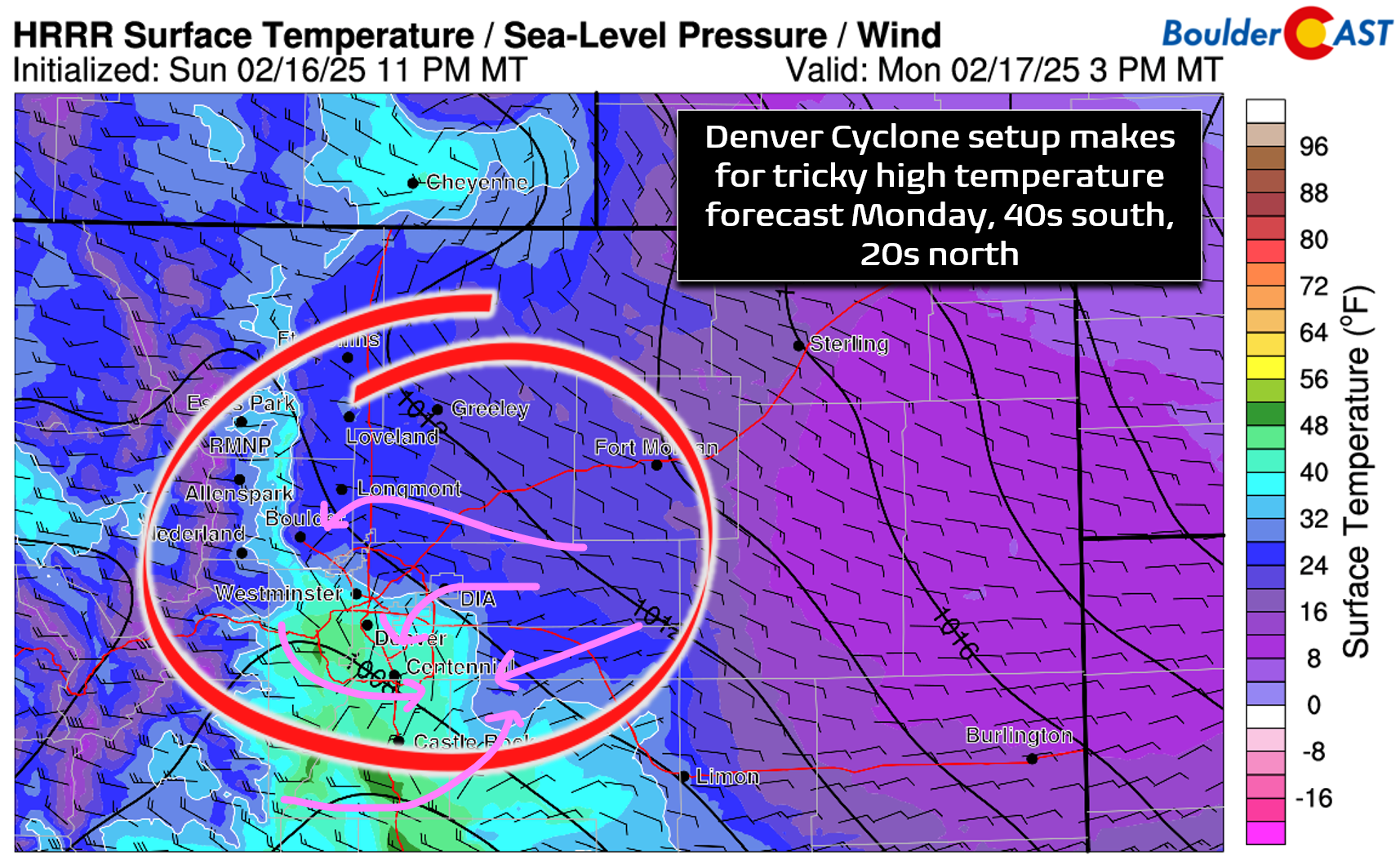
The initial Arctic front will move through on Monday, but the brunt of this week’s frigid air will be felt Tuesday through early Thursday. High temperatures on Monday will be quite varied across the lower elevations thanks to a Denver Cyclone wind field, with areas south of Denver reaching the 40s while northern areas stay in the 20s. There will be quite the gradient across the Metro area — take a look at the temperature forecast map below to see where your neighborhood may land. Boulder likely stays in the 20s Monday afternoon, stuck in chilly east-northeasterly flow at the surface. Foothills communities will be warmer and some of them above freezing.
A strong 1045 millibar Artic high will build southward into Montana and Wyoming by early Tuesday, ushering in upslope flow at the same time.
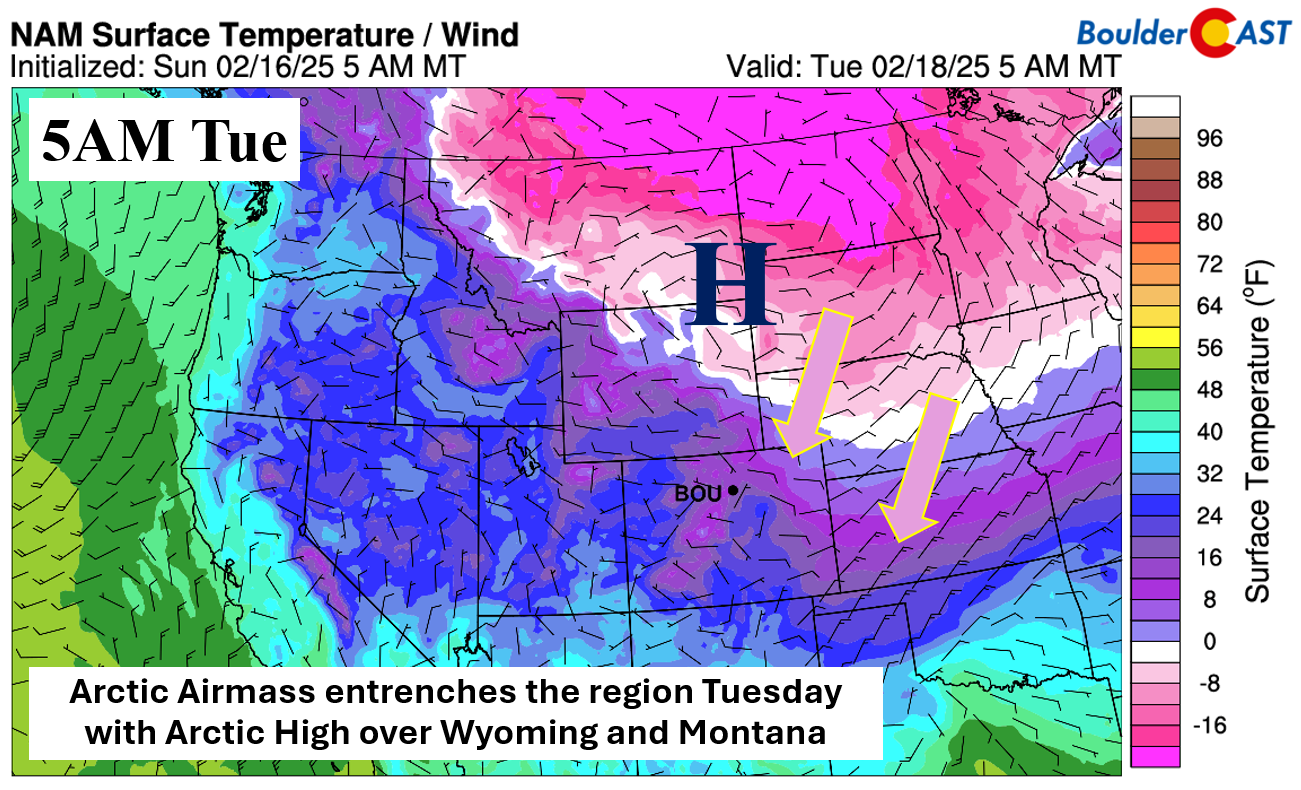
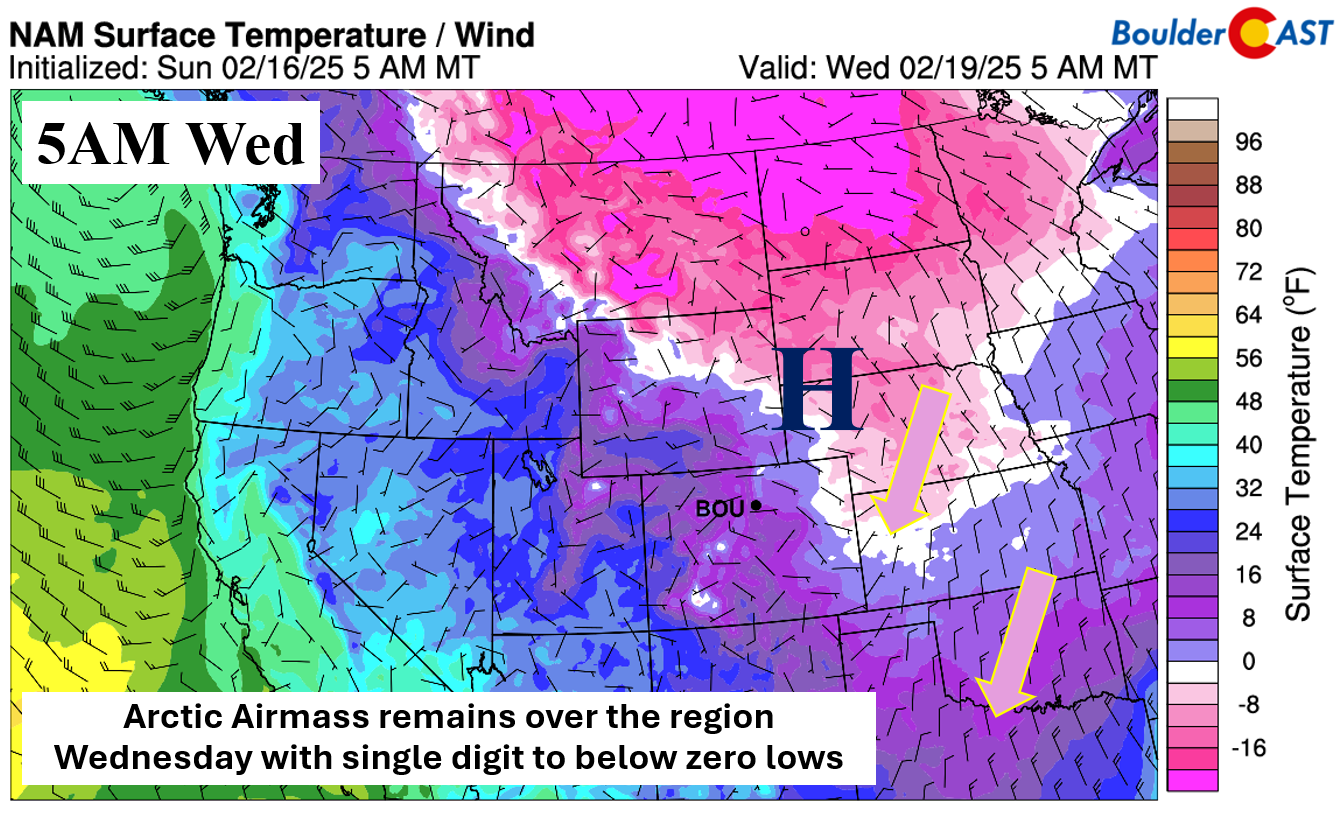
By midweek on Wednesday, the strong and anomalous Arctic high will be just to our east in Nebraska and Kansas, with cold easterly and upslope flow continuing. Highs Tuesday and Wednesday are likely to struggle to get out of the teens in our area. As for lows these next few nights, single digits to below zero readings are likely, especially if some light snow can accumulate Monday night.
Speaking of that light snow, a system in the westerly flow aloft will move through Monday evening and night, progressing into the central Plains by Tuesday. All in all, the flow is predominantly downslope in nature, which usually means limited snow accumulations for Boulder and Denver.

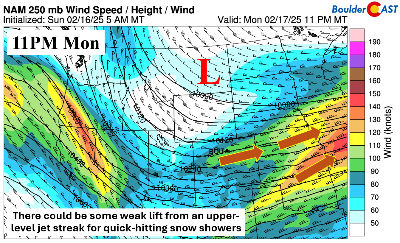
There is a weak upper-level jet streak moving overhead Monday night. It could provide a small amount of enhanced lift and favor a few quick-hitting snow showers across the Denver Metro area. However, its position would favor areas mostly to our south and east along Interstate 70 towards Kansas, so this is not ideal either.
Not surprisingly, the HRRR shows little if any snow Monday into Tuesday morning with the Arctic front and upper-level wave. The main accumulation will be across the higher terrain along/west of the Continental Divide with upslope westerly flow hammering that area. A second area of accumulation is over the far eastern part of the state, which will benefit most from the upper-level jet and shortwave energy.
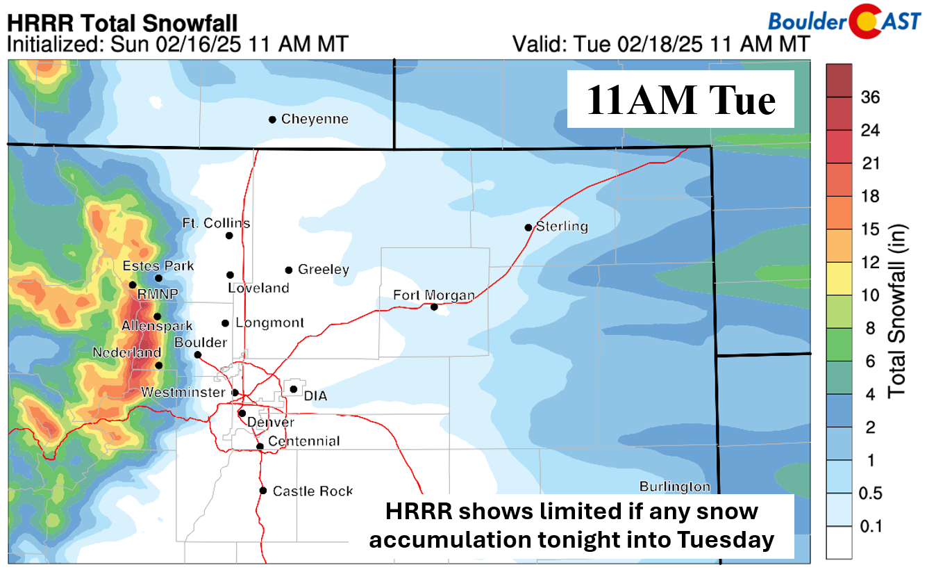
The NAM-NEST below is similar to most of the global and regional models, showing about a trace to an inch or less of snow by Tuesday morning in the Metro area.

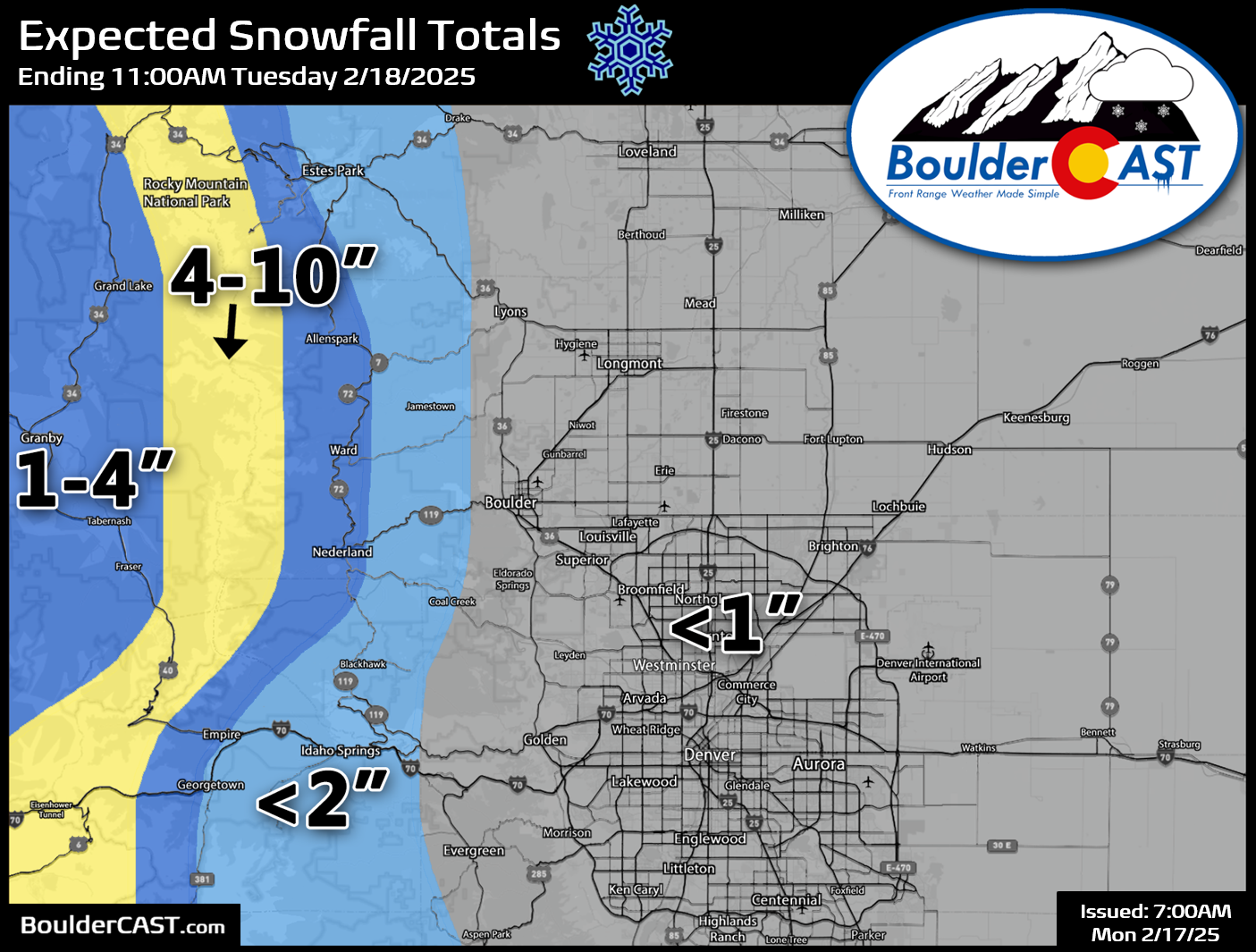
All in all, this is not an impactful system in terms of snowfall. Most areas will see an inch or less of snow, except up along the Divide which could see up to 10 inches by Tuesday morning. Areas along Peak-to-Peak Highway in western Boulder County may see up to 4 inches of spillover snow from the Divide.
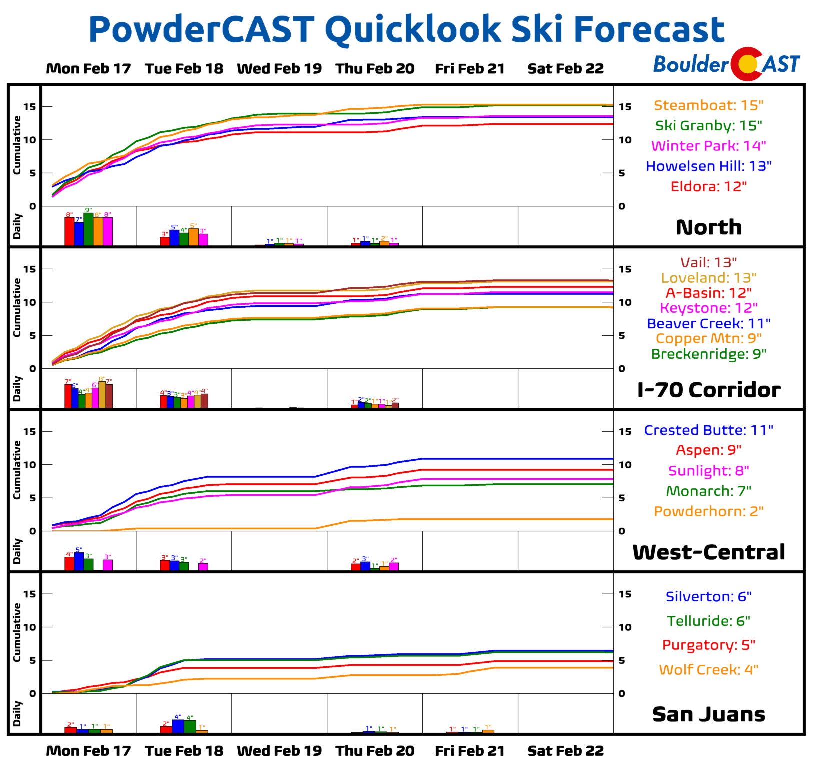
Skiers will continue to be showered with powder this week, with northern resorts likely to see more than a foot of snow:
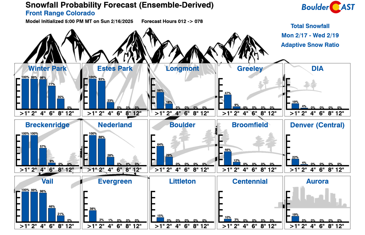
A secondary surge of Arctic air will ooze into the area Tuesday afternoon into Tuesday night. There’s not much moisture or energy to work with outside of the shallow upslope flow, but most models are showing widespread very light snow impacting the Denver Metro area, especially on the northern side Tuesday night. This would mostly be in the form of flurries, or perhaps on-and-off very fine snowfall. For now plan on a encore round of light accumulating snow focused mainly on Tuesday evening and night, with up to another 1″ of accumulation possible, but maybe up to 2″ in favored upslope locations like Boulder. Our Snowfall Probabilities indicate a ~65% chance to see 1″ of snow in Boulder between the two early-week snows, with ~30% chance to see 2″ or more. Elsewhere, away from the terrain, the snow outlook is much less favorable.
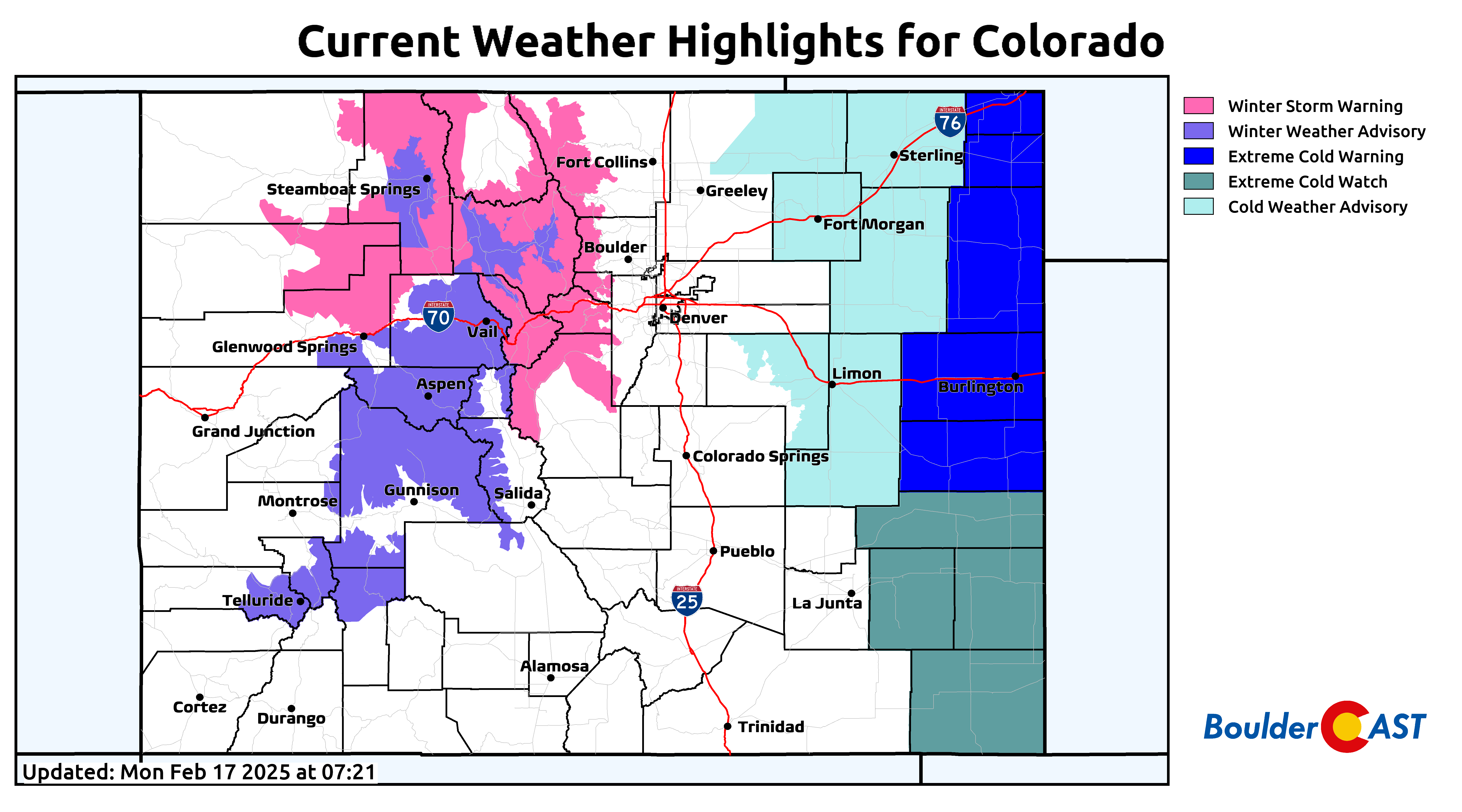
High temperatures both Tuesday and Wednesday will struggle to reach the 20-degree mark across the lower elevations, especially north of Denver where teens are favored. Overnight lows will be cold but nothing record-shattering. Tuesday, Wednesday, and Thursday mornings will start out in the single digits, with favored cold spots having a shot at dropping slightly below zero. Fortunately there won’t be much snow this week and there will be plenty of cloud cover — two factors working to keep temperatures from getting too cold here. As of writing early Monday, weather highlights are posted for heavy snow (Mountains) and bitter cold (eastern Plains), with the Boulder-Denver area not forecast to receive enough snow or cold for either to be issued here.
Late-week moderating temperatures
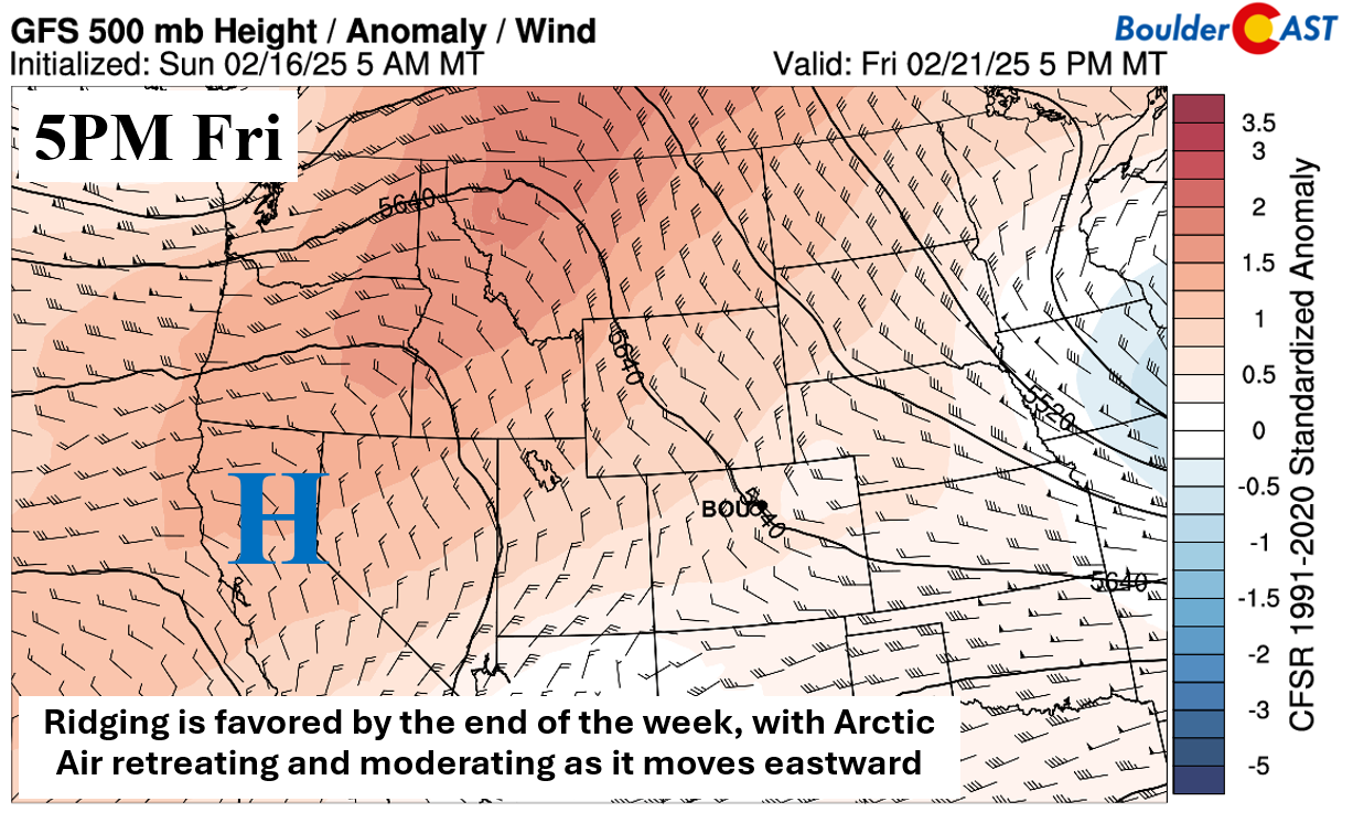
As we head into the latter part of the week, there are signs that the Arctic air will moderate somewhat and also retreat to the east. Eventually, ridging offshore of the West Coast will move inland and build over the state this coming weekend. But before that happens, guidance does indicate that an upper wave will traverse across in the west to southwest flow. All model guidance shows a system coming through, but differ on its track and intensity, and thus the resulting impacts it will have in our neck of the woods. Models are not in agreement on its overall potential to produce snow across the Front Range. If it does lead to measurable snow, the probability of impactful accumulations appears limited thus far, but it will need to be watched.
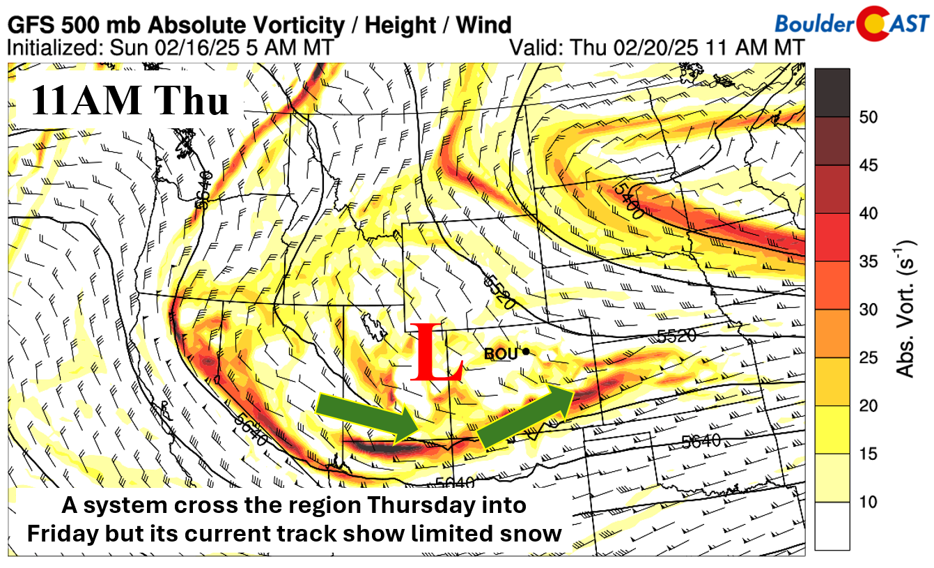
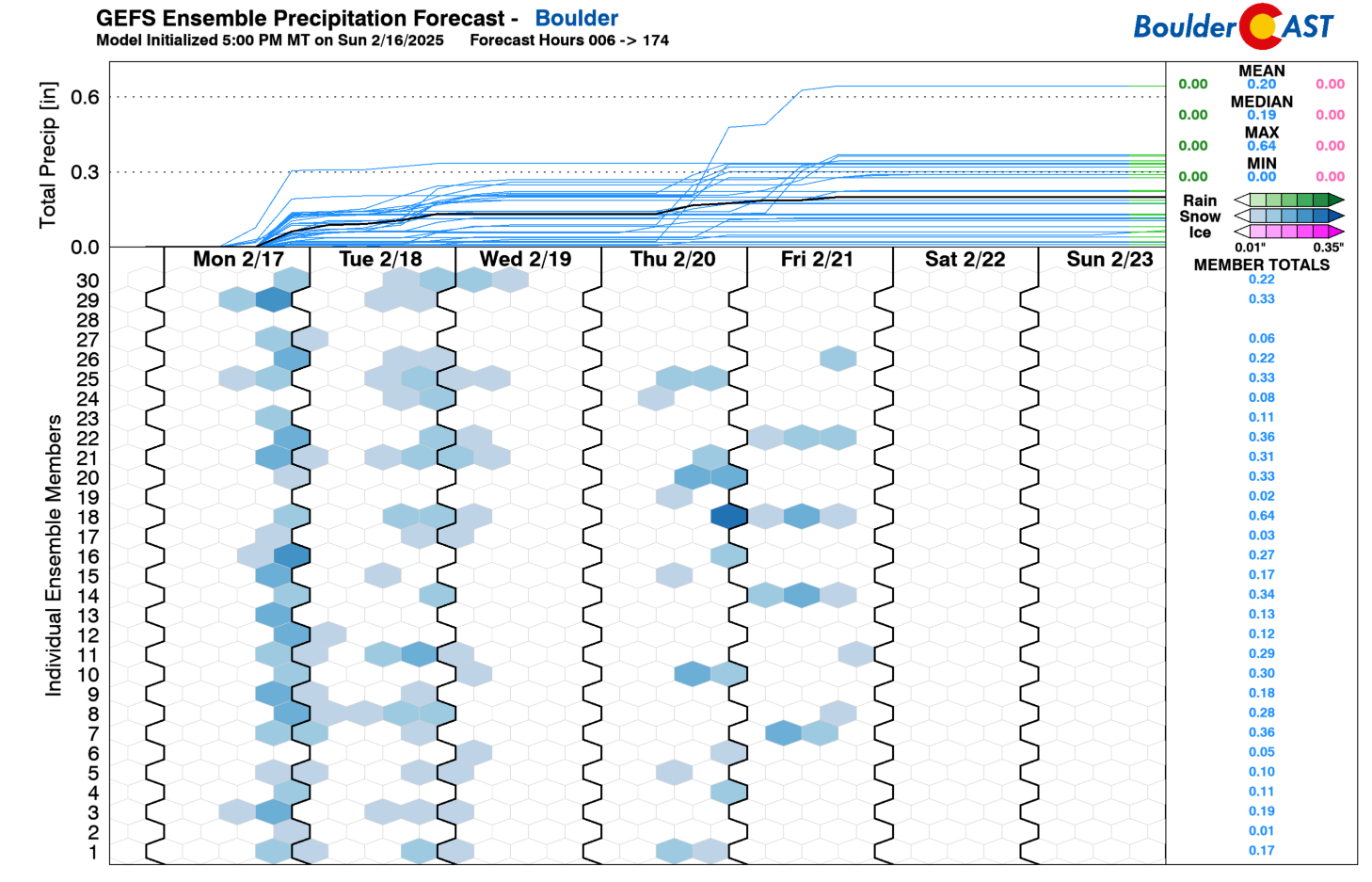
Our GEFS ensemble plume forecast shows several members generating sporadic accumulating snow Thursday into Friday, keeping our confidence low at this point but our interest elevated.
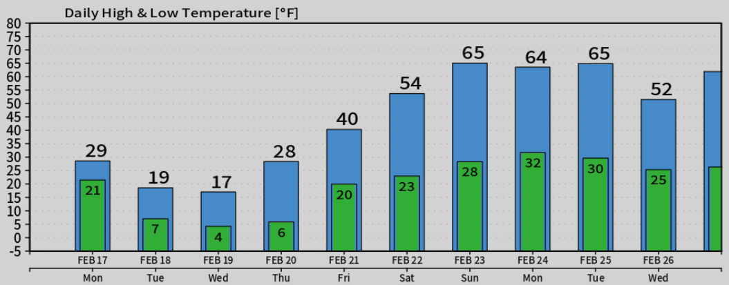
After highs on Thursday still in the 20s, we should moderate closer to 40 degrees by Friday with sunshine returning.
Most models suggest we will return to the 50s and 60s this upcoming weekend into early next week — so that will be a nice treat alongside dry weather! The graphic below shows our high and low temperature forecasts from the Euro model throughout the extended:
For the first time in ages, our weekly planner includes a chance of snow every single day this week, albeit minor chances and only for light snow. Enjoy the plunge back into the freezer!
Forecast Specifics:
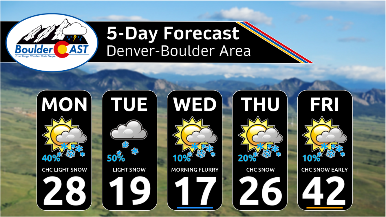
Monday: Mostly cloudy and chilly. Highs reach the 20s (north) to lower 40s (south). Spotty light snow will develop during the day and continue into overnight with up to 1″ of accumulation possible by sunrise Tuesday. Lows drop into the single digits.
Tuesday: Overcast and cold. Light snow or flurries develop late in the day with minor accumulations possible (dusting to 1″). Highs only around 20 degrees on the Plains with teens in the Foothills. Lows Tuesday night in the single digits to slightly below zero.
Wednesday: Bitter cold under partly cloudy skies with a few lingering morning flurries or light snow. High temperatures around 20 degrees across the Plains with teens in the Foothills. As skies clear Wednesday night, the entire area will drop below zero to a few degrees above.
Thursday: Still remaining cold with middle 20s in the Denver Metro and middle to upper teens in the Foothills under increasing clouds. There is a slight chance of light snow in the day and evening.
Friday: A mix of clouds and sun and warmer, with possibly a few lingering bouts of light snow early on. Highs near 40 degrees in the Denver Metro and lower 30s in the Foothills.
Weekend: Warmer and dry with 50 to 60s for highs on the Plains. Get ready for several days of warm weather!
Get BoulderCAST updates delivered to your inbox:
DISCLAIMER: This weekly outlook forecast is created Monday morning and covers the entire upcoming week. Accuracy will decrease as the week progresses as this post is NOT updated. To receive daily updated forecasts from our team, among many other perks, subscribe to BoulderCAST Premium.
Go Premium, get all the perks.
Daily Forecast Updates
Get our daily forecast discussion every morning delivered to your inbox.
All Our Model Data
Access to all our Colorado-centric high-resolution weather model graphics. Seriously — every one!
Ski & Hiking Forecasts
6-day forecasts for all the Colorado ski resorts, plus more than 120 hiking trails, including every 14er.
Smoke Forecasts
Wildfire smoke concentration predictions up to 72 hours into the future.
Exclusive Content
Weekend outlooks every Thursday, bonus storm updates, historical data and much more!
No Advertisements
Enjoy ad-free viewing on the entire site.
Enjoy our content? Give it a share!


You must be logged in to post a comment.