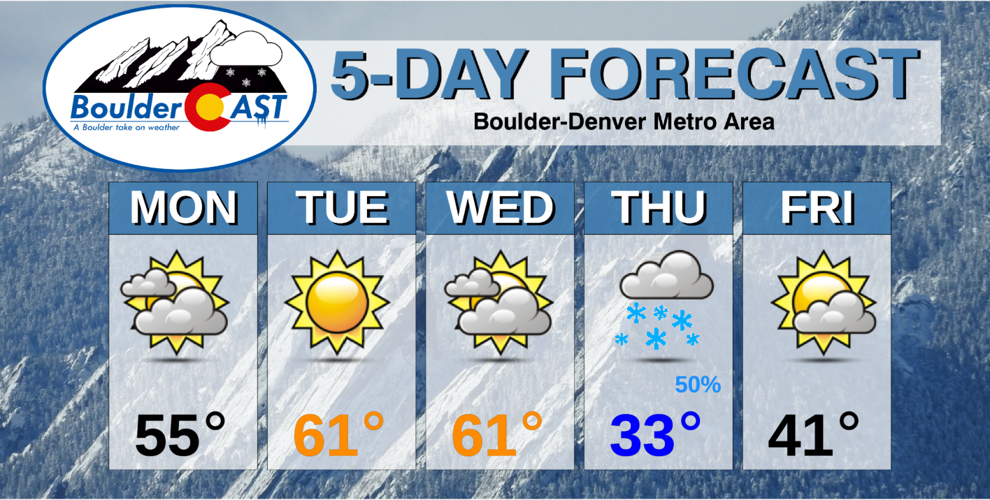
A rather benign and warm stretch will kick off the month of February. However, it will turn sharply colder with chances of snow late in the week and for the upcoming weekend. Read on for more details.
This week’s highlights include:
- High pressure ridging persists through mid-week with very pleasant temperatures and dry conditions
- A trough brings colder air and light snow chances for all of Colorado late Wednesday through Thursday
- We are monitoring the potential for frigid temperatures and a secondary chance of snow for the upcoming weekend, though this pattern is more uncertain
DISCLAIMER: This weekly outlook forecast is created Monday morning and covers the entire upcoming week. Accuracy will decrease as the week progresses as this post is NOT updated. To receive daily updated forecasts from our team, subscribe to BoulderCAST Premium.
A warm start to February!
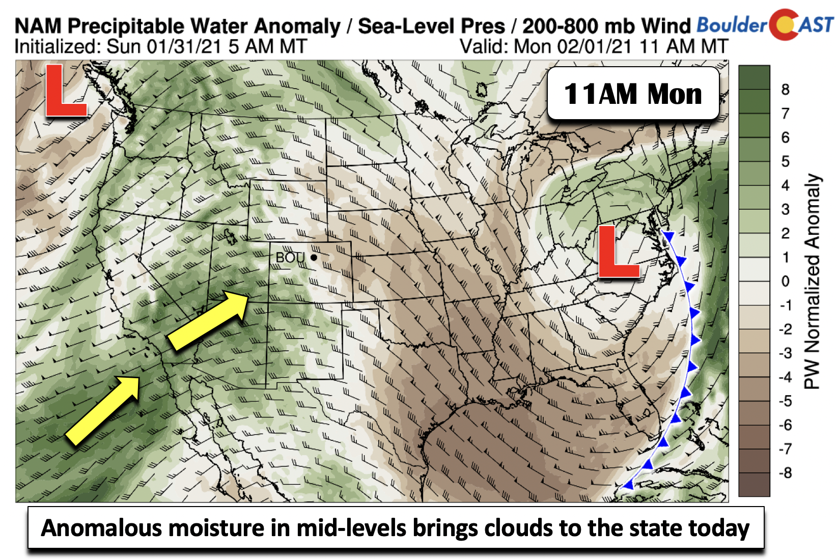
Rather benign weather starts the week for us along with above average temperatures. Shown below are anomalies in atmospheric moisture for Monday. While the western U.S. will be under high pressure ridging, above normal moisture is penetrating into the southwestern U.S. and also into Colorado, as noted by the green shading below. This is in response to deep troughing over the Pacific Northwest.
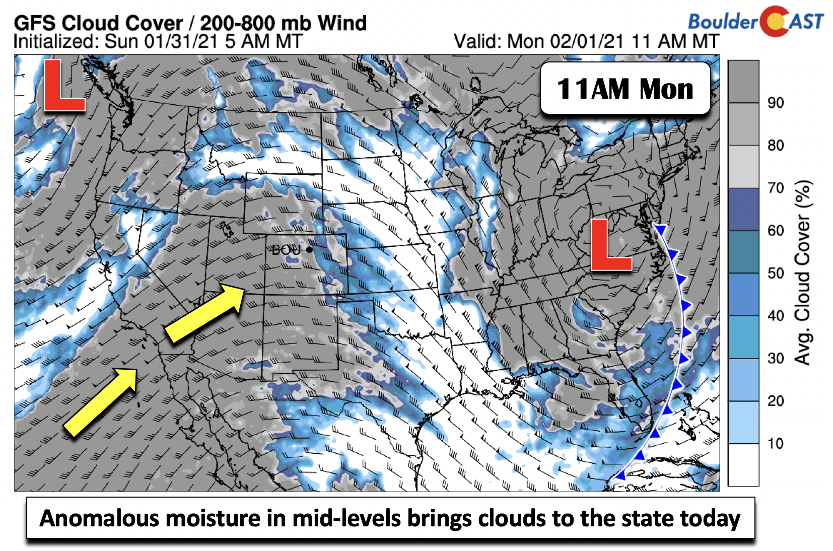
With this moisture pushing in at the mid and upper-levels of the atmosphere, cloud cover will be prevalent, especially Monday afternoon and evening (below). Normally under this airmass we would expect highs in the upper 50’s to near 60. But the clouds should keep highs this afternoon in the low to middle 50’s.
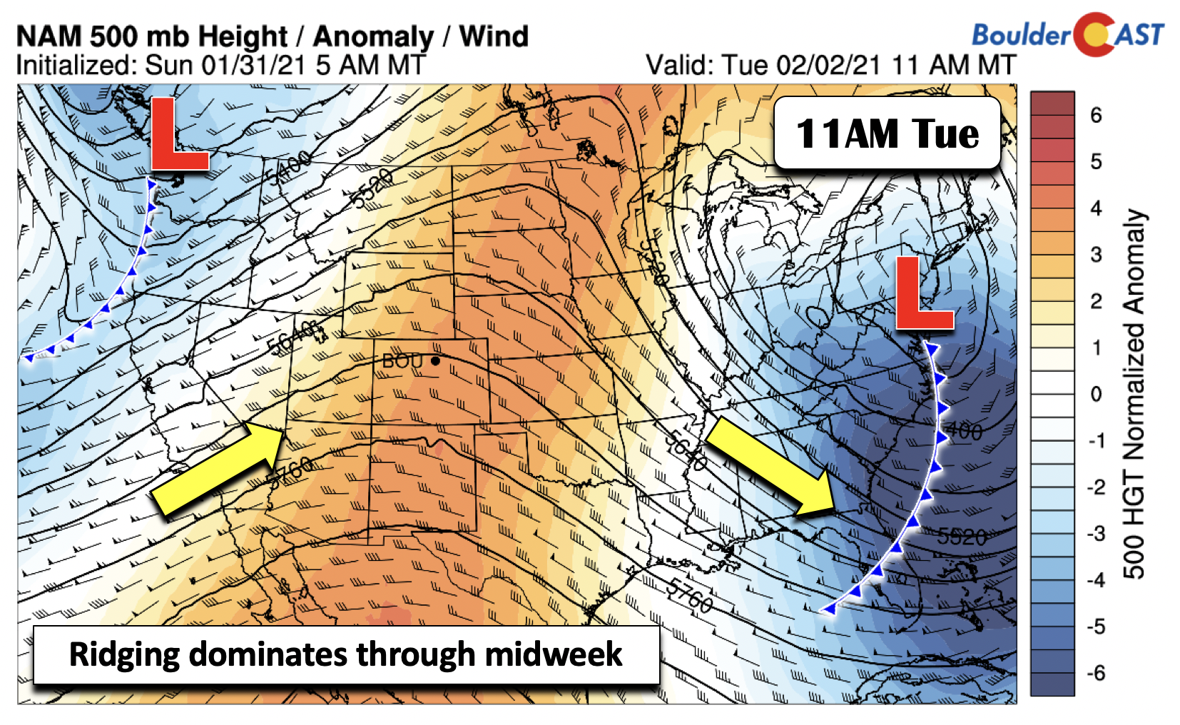
Colorado will largely be under this same high pressure ridging through Wednesday (below). With a lack of clouds on Tuesday, that should be the most gorgeous day of the week in the upper 50’s and possibly even lower 60’s, about 15 degrees above normal for early February.
Approaching snow storm Wednesday-Thursday
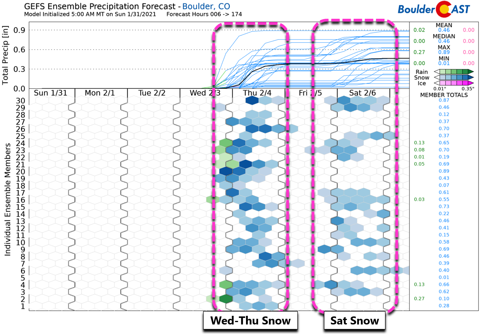
Ensemble guidance is in good agreement that we have two chances of snow this week and weekend. The first is this Wednesday night to early Thursday, with a secondary shot on Saturday (both are shown below). Wednesday will be mild too with highs well above average in the upper 50’s to lower 60’s with mostly cloudy skies under warm pre-frontal southwesterly flow.
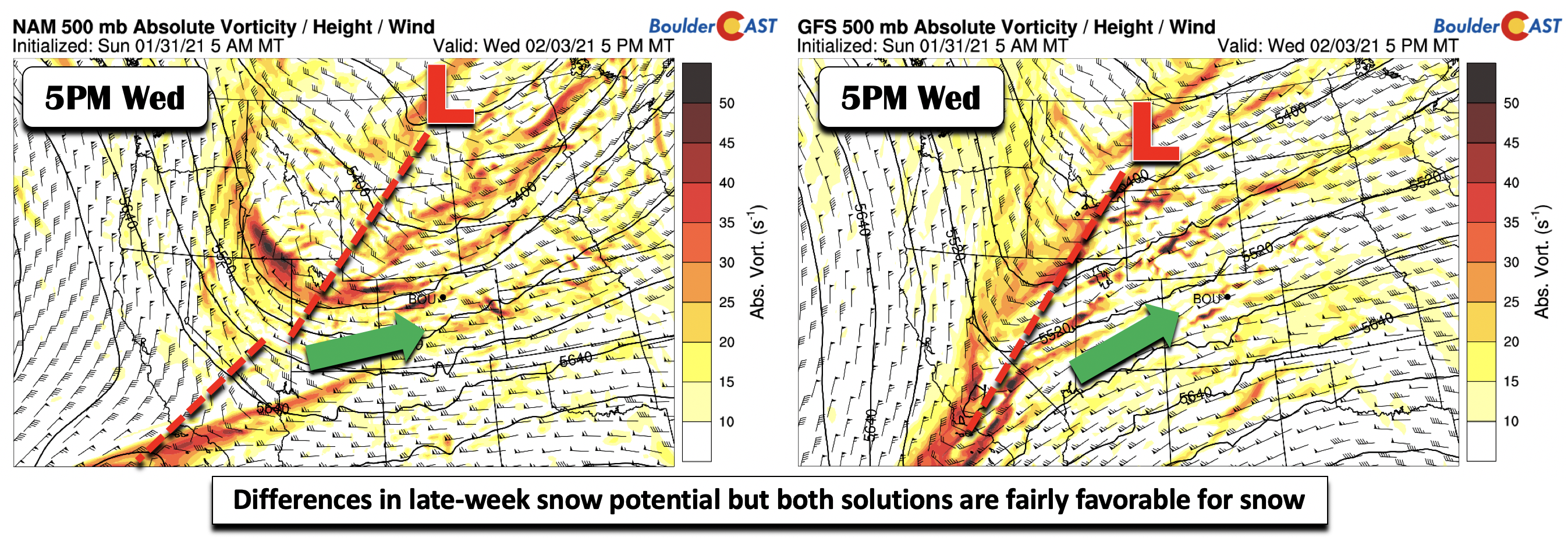
While there is good agreement for snow Wednesday night into Thursday from ensemble forecasts, the deterministic models still show noticeable differences, with the NAM (below left) faster and further north with the trough axis, while the GFS (below right) is slower and more south, allowing for a better moisture source for snow. However, don’t fear! Both solutions are fairly favorable for some snow on the Front Range and the Mountains. It should be noted the ECMWF is also slower and in better agreement with the GFS, so its solution was favored in our forecast.
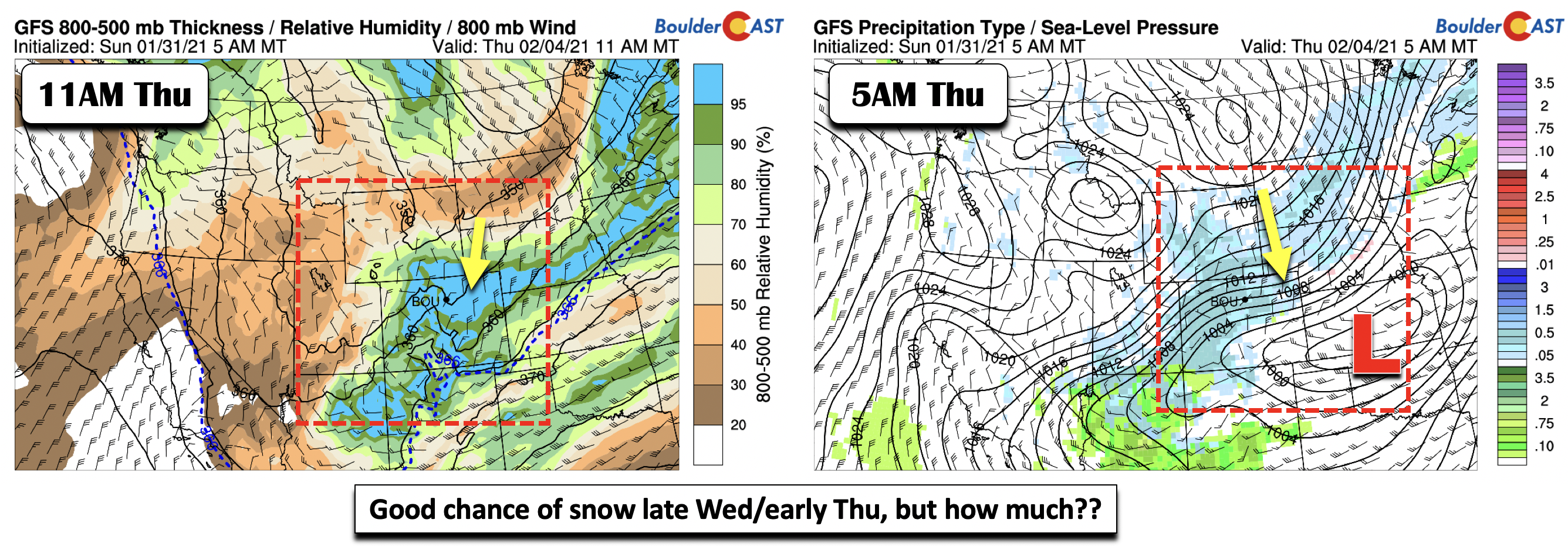
If things trend toward the GFS/ECMWF solutions as we expect, it would favor upslope and perhaps some jet forcing as well. This will produce a period of snow Thursday across the Denver Metro area (below). Note the rain/snow line (below left: dashed blue contour) is well south of Colorado, indicating this will be an all-snow event. The Front Range has been burned several times this winter with systems that appear promising but later trend towards a drier or more southern solution – given our La Niña pattern. One thing that could jeopardize this snow potential would be if the trough ends up taking a direct west-northwest to east-southeast track. This would favor downslope and minimal snow for us. However, we don’t fully see that happening at the moment, but stay tuned as we get closer. Highs Thursday and will drop considerably from earlier in the week back into the lower to middle 30’s, with just a slight rebound expected on Friday into the lower 40’s.
Weekend looks cold with another chance of snow
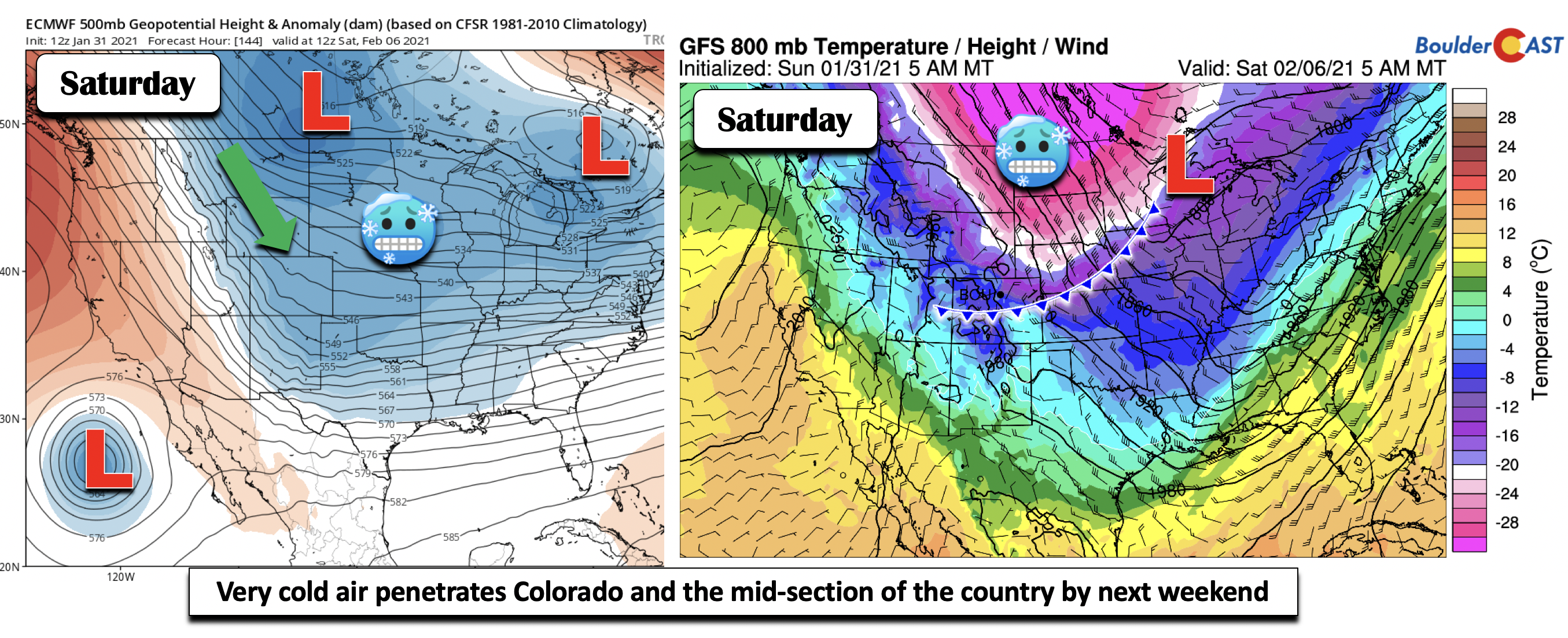
Yet another shot of cold air and snow is looking favorable on Saturday. The GFS/ECMWF solutions and the ensemble guidance (shown earlier) indicate a deep penetration of frigid air over the mid-section of the country late Friday and Saturday, continuing through the upcoming weekend. The axis of the coldest air will likely get close to Colorado (below right). Note in the below left image the deep troughing over much of the U.S. on Saturday, indicating well below average temperatures. Embedded in this cold air will be a period of upslope potential in combination with a trough pushing in from the northwest. This pattern could produce a period of snow Saturday or Sunday for our area. As is often the case, eastern Colorado will likely be on the very western fringe of the Arctic airmass (unlike the middle of the country). Any slight shift in the pattern could shelter us from the cold air intrusion. It’s too far out to say for sure, but signs are pointing to a colder and at least somewhat snowy weekend ahead.
Enjoy the warmth before the bottom falls out later this week. Our fingers are cross for snow….we hope yours are too!
Forecast Specifics:
Monday: Becoming mostly cloudy with highs in the low to middle 50’s on the Plains and lower 40’s in the Foothills.
Tuesday: Sunny and very pleasant and warm with lower 60’s on the Plains and near 50 in the Foothills.
Wednesday: Partly cloudy skies becoming overcast. Highs in the lower 60’s on the Plains and upper 40’s in the Foothills. A chance of snow exists late Wednesday night.
Thursday: Light snow possible during the day with temperatures much colder. Highs in the lower 30’s on the Plains and lower 20’s in the Foothills.
Friday: Partly cloudy skies with a chance of snow developing Friday night. Highs in the middle 40’s on the Plains and middle 30’s over the Foothills.
Weekend: Another chance of snow is possible Saturday to Sunday with much colder temperatures, potentially with highs in the lower 20’s. The exact track of the bitter cold air remains uncertain, though, with Colorado likely on the edge.
Mountains: Quiet weather starts out over the higher elevations through Tuesday. Gusty winds and snow develop late Wednesday and continue Thursday, along with a chance of snow over the weekend. Gusty winds and cold temperatures will develop over the weekend as well. Between the two snow chances this week, many mountain resorts can expect between 5 and 12″ of new snow.
Help support our team of Front Range weather bloggers by joining BoulderCAST Premium. We talk Boulder and Denver weather every single day. Sign up now to get access to our daily forecast discussions each morning, complete six-day skiing and hiking forecasts powered by machine learning, first-class access to all our Colorado-centric high-resolution weather graphics, bonus storm updates and much more! Or not, we just appreciate your readership!
.
Spread the word, share the BoulderCAST forecast!
.





You must be logged in to post a comment.