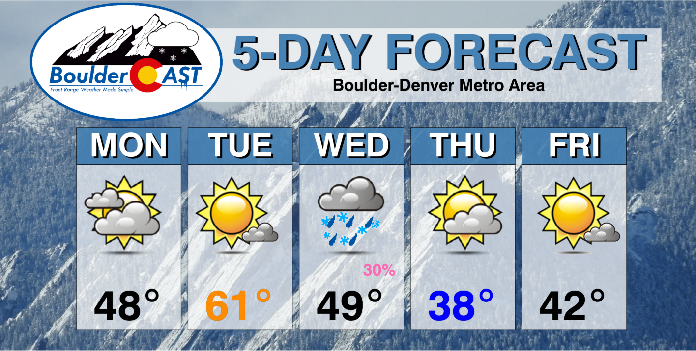
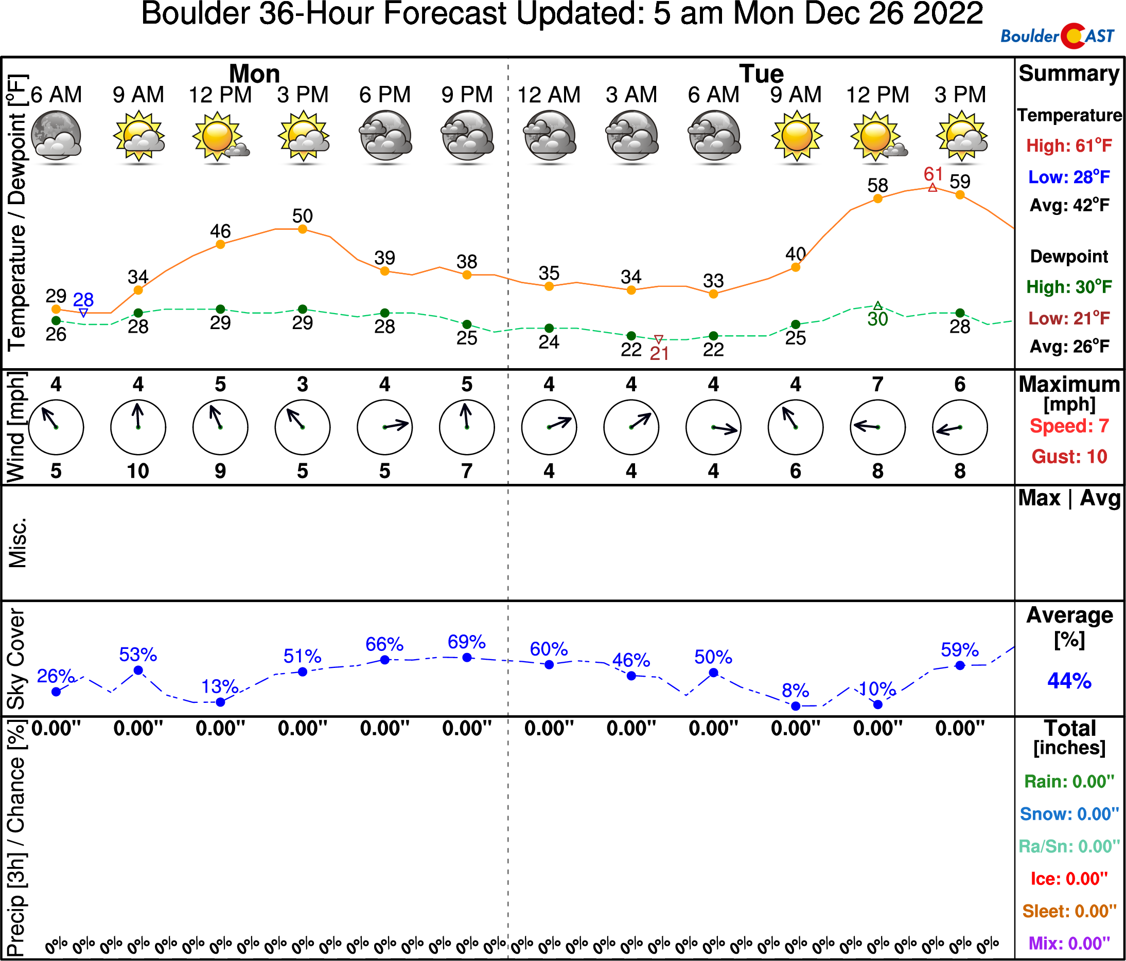
Following a mild but technically “white” Christmas on Sunday, the week starts off quiet with a nice warm-up planned for Tuesday into the 60s. A southern-track system will bring heavy snow to the Mountains Tuesday night into Thursday, along with a good snow chance for the Metro area Wednesday night as well. Following a cold front, the week will conclude with seasonal temperatures.
This week’s highlights include:
- Lots of high clouds to start our week with highs in the upper 40s
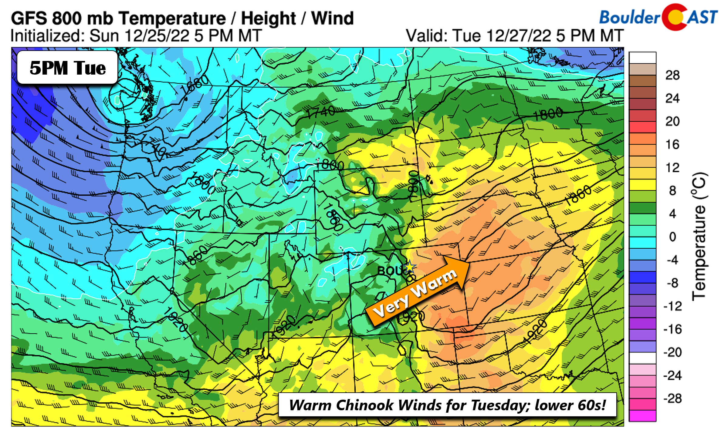
- Tuesday is our warmest day with some spots in the lower 60s thanks to warm Chinook winds, watch for gusts up to 75MPH in the Foothills though!
- A southern-track system brings snow the state Tuesday night into Thursday — including some snow to the Denver Metro area Wednesday night
- The week ends cool but quiet
- Another chance of snow may arrive late in the upcoming weekend into early next week with another southern-track wave of low pressure
DISCLAIMER: This weekly outlook forecast is created Monday morning and covers the entire upcoming week. Accuracy will decrease as the week progresses as this post is NOT updated. To receive daily updated forecasts from our team, among many other perks, subscribe to BoulderCAST Premium.
The first White Christmas since 2017
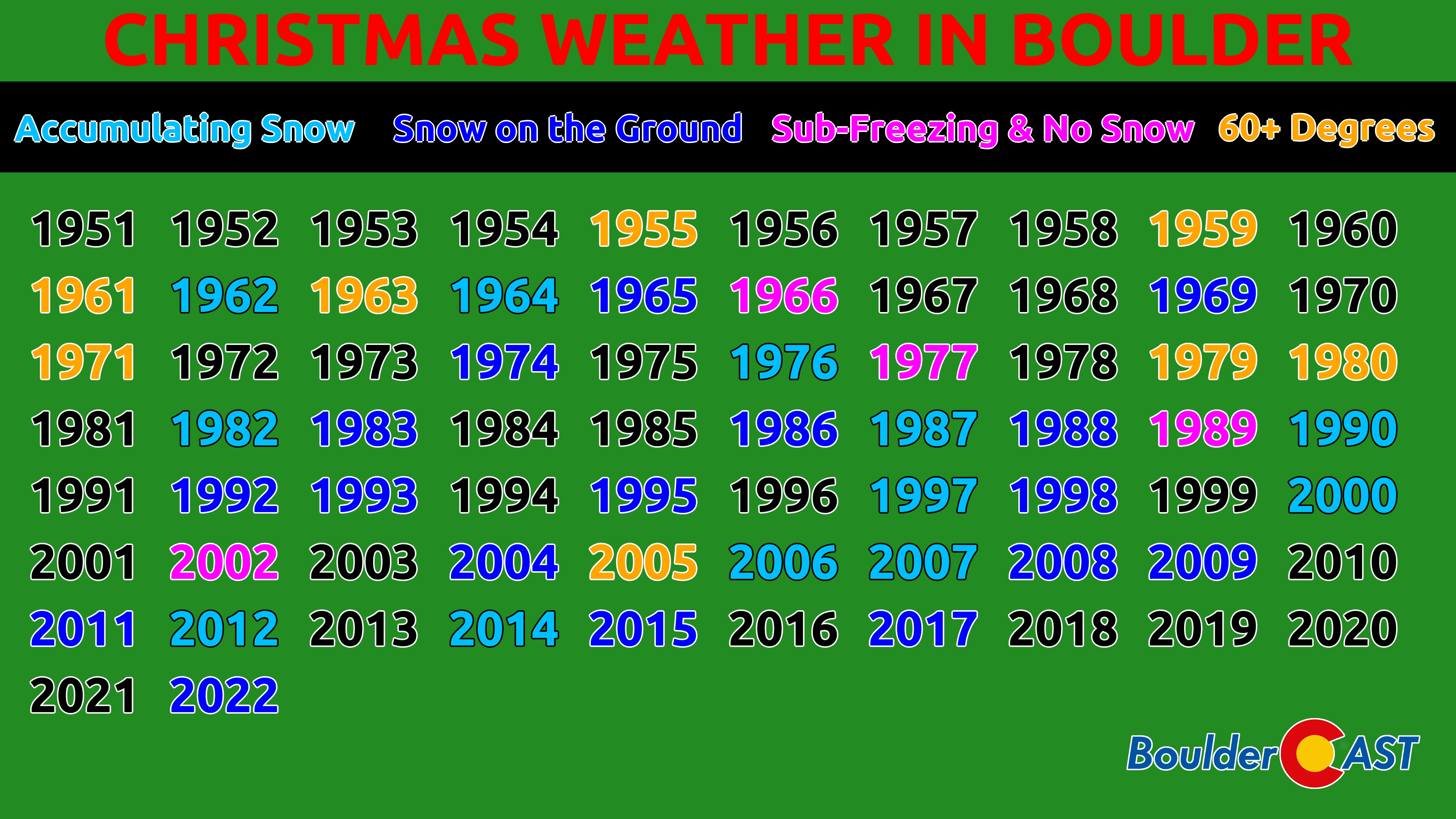
Thanks to the Arctic blast, the snowfall the accompanied it last week, and the bitter cold days that followed behind, Sunday ended up being our first White Christmas since 2017 as Boulder and Denver officially measured 2″ of snow still on the ground Sunday evening. The graphic below shows a high-level summary of Christmas weather over the last 70+ years in Boulder. In our book, a “white” Christmas is either one where snow actually falls and accumulates, OR there is at least 1″ of old snow on the ground. This year was the latter.
Though it was a bit windy at times, temperatures were above normal in the lower 50s across the lower elevations which made for great conditions to be out and about enjoying the holiday! You could not really ask for better local travel, though the massive storm system impacting the rest of the country had an indirect effect with many flights being cancelled or delayed out of Denver International Airport during the weekend.
We start off quiet with a nice warm-up Tuesday
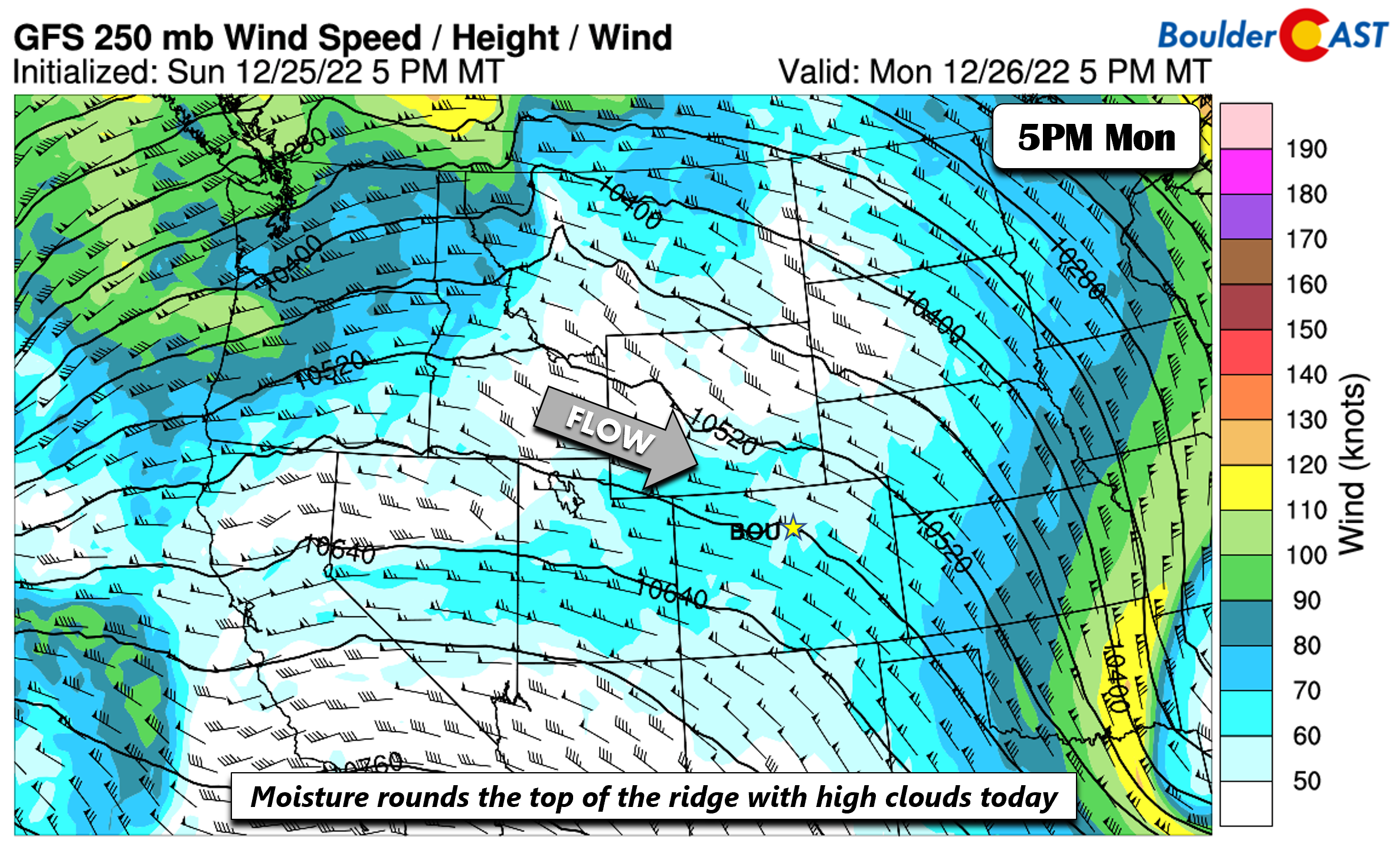
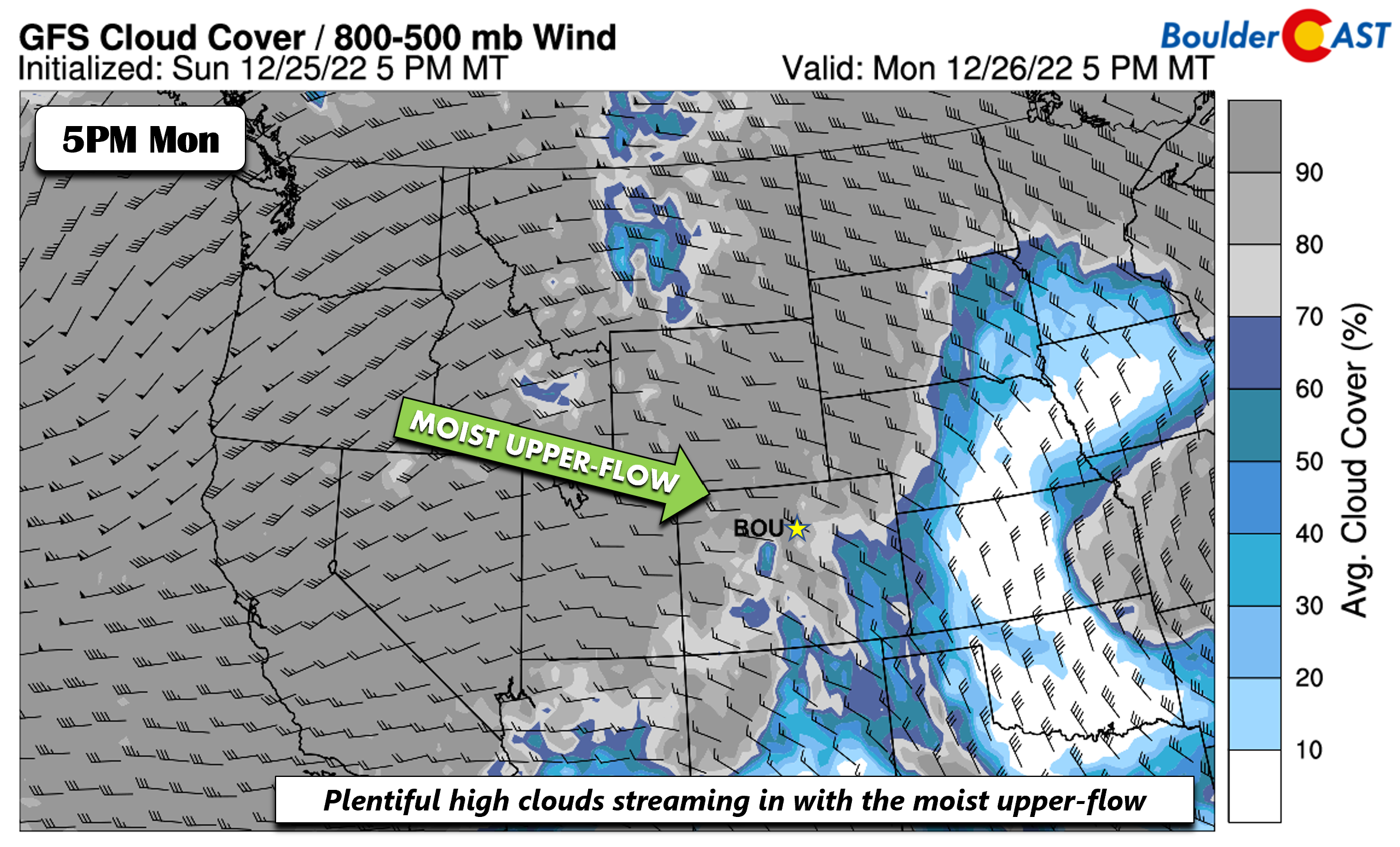
The week starts off quiet across Colorado. We’re happy about this considering just how crazy it was last week. On Monday a ridge axis extends into the western US, with the center of that high pressure well to our southwest. A stream of deep moisture in the upper-levels of the atmosphere from a system offshore of the Pacific Northwest will ride around the ridge axis today into Colorado.
This moisture arcing around the ridge axis will lead to numerous mid and high cloudiness across the state. This should make for a milky sky during most of our afternoon hours.
Highs this afternoon will be just a tad cooler than Sunday with highs around 50 degrees. Winds are expected to be light behind a cold front that has moved through from the east last night.
Come Tuesday, the Pacific Northwest system will move onshore. In time, that westerly flow in the low-levels will favor a warm Chinook wind on the eastern Plains of Colorado and Kansas. Very warm temperatures will unfold as a result for the Denver Metro area with most areas in the lower 60s. If you have time, do a late-day hike after work or take off work all together. This will be our warmest day of the week! Some gusty winds at times will be possible on Tuesday too, between 15-25 MPH across the lower elevations.
In the Foothills, there will be some wave enhancement of the winds leading to gusts up to 75 MPH at times on Tuesday. As of writing on Monday, a High Wind Watch has been posted for the Foothills. At this time, it does not appear these very strong west winds will not making it down into Boulder.
Snow in the Mountains Tuesday through Thursday with a chance on the Plains
Clouds will be on the increase Tuesday night as deep moisture streams in from the southwest. While the aforementioned system will track along through Montana/Alberta Tuesday night into Wednesday, a southern stream wave will enter the southwest US come the middle of the week. While this system won’t reach the Plains until late Wednesday and Thursday, the deep moisture penetrating into the Mountains of western Colorado Tuesday night will favor deep upslope for heavy snow starting then through early Thursday. This will lead to many inches of snow for the High Country by the latter part of the week — good news indeed for the skiers!
The mid-level system will take a slightly southern track from Utah into southern Colorado Wednesday night into early Thursday, before scooting to the northeast. The storm track is not the most favorable for snow in the Denver Metro area, but we’ll dive in a little closer to see if there are hints of higher amounts.
the GFS, and somewhat the Canadian, indicate a surface area of low pressure taking an east-northeast track across our area early Thursday, with a northwest downslope flow largely in place — there is not much upslope in these models. The surface temperatures are also borderline as a cold front slides through late Wednesday night.
The GFS total snowfall through 5 PM Thursday shows some accumulation on the Plains, perhaps 1-2″ worth across the Metro area. Meanwhile, more than a foot of snow is likely west of the Divide by late Thursday.
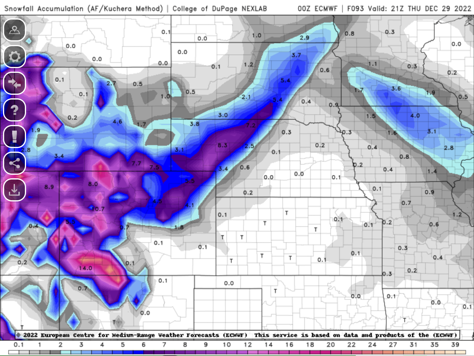
The Euro model is higher on snow amounts for the Plains late Wednesday into Thursday, showing roughly 4 to 7 inches. It is difficult to pin down why the ECMWF is stronger than the GFS/Canadian models, given that is shows a similar storm track. One idea is that the model does in fact show a stronger surface low with a more pronounced wrap-around flow banked up along the Foothills making for a longer duration of upslope. As a result, amounts are higher compared to the GFS.
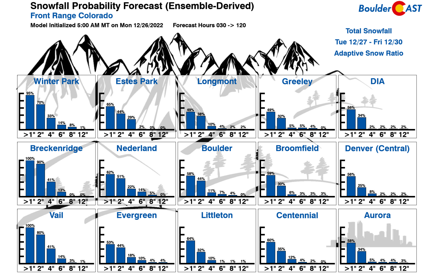
A look at the ensemble data, including the GEFS (below), is less enthused, with a 50-70% chance of snow amounts greater than 1 inch over Denver and Boulder. The probabilities for 4+ inches are lower between 5-10%. We will have to continue to monitor this as these southern-track systems can change drastically as we get closer. Our gut feeling now is that this won’t be a major storm for us producing just a few inches or less of snow for the lower elevations.
Another southern-track system possible later in the weekend
Following the system on Thursday, cold air will remain in place for week’s end with temperatures largely in the lower 40s. By Saturday, a slight warm-up will take place under zonal flow. We are expecting middle to upper 40s into Sunday. Come Sunday into early next week, the ensemble data and deterministic guidance indicate another southern track system taking aim on the region. While it is fairly far out, the models appear more excited than the storm for this Wednesday.
The GEFS for this coming Sunday into Monday of January 2023 (Happy New Year!) shows several members with snow in the forecast. This will be something to continue to watch for as well as the week progresses. Enjoy the last week of 2022 and don’t forget to submit your completed BoulderCAST 2022 Crossword!
Forecast Specifics:
Monday: Mostly cloudy with highs near 50 degrees on the Plains and upper 30s to lower 40s in the Foothills
Tuesday: Partly cloudy, gusty, and very warm for December, then increasing clouds in the evening. Highs in the lower to middle 60s on the Plains and lower 50s in the Foothills. Winds will gusts up to 75 MPH in the Foothills during the day.
Wednesday: Mostly cloudy and cooler. Highs near the lower 50s on the Plains and near the lower 40s in the Foothills. Snow will be possible late Wednesday into Thursday morning with up to a few inches of accumulation possible so stay tuned!
Thursday: A chance of snow in the morning, otherwise mostly cloudy and cool. Highs in the upper 30s to around 40 on the Plains and lower 30s in the Foothills.
Friday: Partly sunny and cool with lower 40s in the Denver Metro area and lower 30s in the Foothills.
Saturday: Partly cloudy and warmer with middle 40s on the Plains and middle 30s in the Foothills.
High Country: Dry weather will start the week in the mountains. However, deep moisture pushing in from the west will favor periods of snow, sometimes heavy, starting Tuesday evening and continuing off and on into the early evening on Thursday. A few feet of snow will be possible by week’s end. Drier weather will return for the late week, with another storm system taking aim late in the weekend and into the early part of 2023.
Help support our team of Front Range weather forecasters by joining BoulderCAST Premium. We talk Boulder and Denver weather every single day. Sign up now to get access to our daily forecast discussion email each morning, complete six-day skiing and hiking forecasts powered by machine learning, first-class access to all our Colorado-centric high-resolution weather graphics, bonus storm updates and much more! Or not, we just appreciate your readership!
Spread the word, share the BoulderCAST forecast!








You must be logged in to post a comment.