Unsettled weather will stay the course this week across Colorado, with a lingering trough keeping rain chances alive early on. A stronger cold front arrives midweek, boosting precipitation chances and bringing a brief return of wintry weather to the higher terrain. Though the weekend ahead looks quite nice, a soggy pattern could be brewing next week. Read on for all the details.
This week’s highlights include:
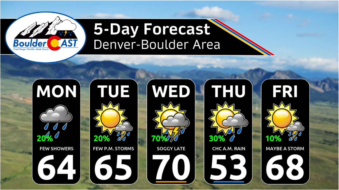
- Unsettled Start to the Week: A weak low-pressure trough will linger over Colorado early in the week, bringing slight chances of rain Monday and Tuesday, with highs in the mid-60s.
- Midweek Cold Front & Rain/Snow: A stronger cold front arrives Wednesday evening, boosting rain chances, especially in upslope-favored areas, with wet snow accumulating in the higher Foothills.
- Chilly Thursday, Then We Warm-up: Thursday will be much colder with lingering morning showers, but a high-pressure ridge moves in Friday, favoring drier and warmer conditions into the weekend.
- Potential Wet Weather Next Week: A developing cut-off low could lead to prolonged wet conditions much of next week, though the forecast remains uncertain.
DISCLAIMER: This weekly outlook forecast is created Monday morning and covers the entire upcoming week. Accuracy will decrease as the week progresses as this post is NOT updated. To receive daily updated forecasts from our team, among many other perks, subscribe to BoulderCAST Premium.

Go Premium, get all the perks.
Daily Forecast Updates
Get our daily forecast discussion every morning delivered to your inbox.
All Our Model Data
Access to all our Colorado-centric high-resolution weather model graphics. Seriously — every one!
Ski & Hiking Forecasts
6-day forecasts for all the Colorado ski resorts, plus more than 120 hiking trails, including every 14er.
Smoke Forecasts
Wildfire smoke concentration predictions up to 72 hours into the future.
Exclusive Content
Weekend outlooks every Thursday, bonus storm updates, historical data and much more!
No Advertisements
Enjoy ad-free viewing on the entire site.
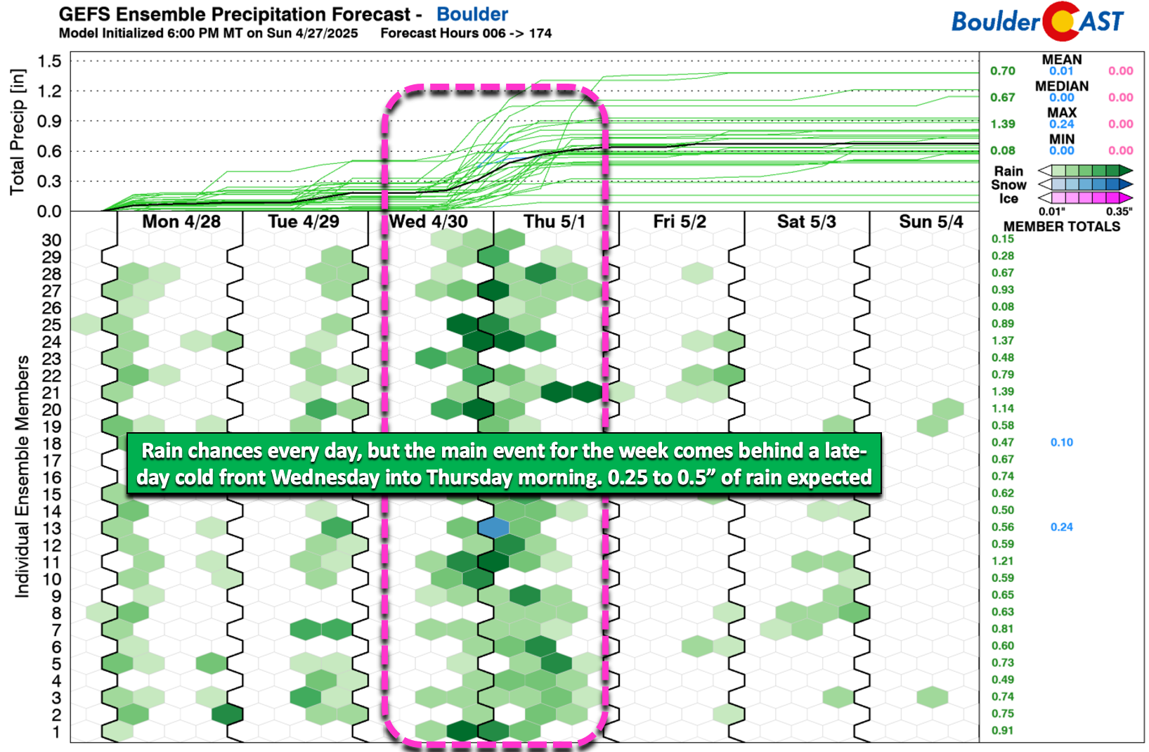
Daily rain chances, but the best comes Wednesday night
We begin the week with a broad but weak trough of low pressure draped across the Intermountain West, including here in Colorado.
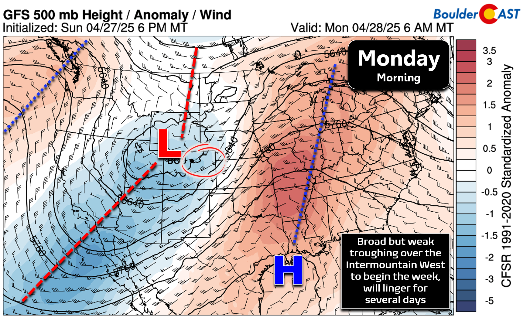
This trough won’t really advance and will eventually get sheared out through the early to middle part of the week. The result will be a somewhat unsettled Monday and Tuesday for us while the trough remains stationary and dissipates over the area.
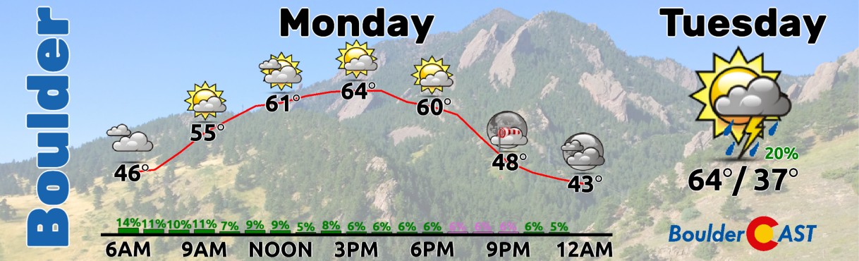
Both Monday and Tuesday will offer slight (20%) chances for rain with high temperatures reaching the middle 60s. Monday will be more of a showery precipitation, while Tuesday will have a chance of thunder mixed in.
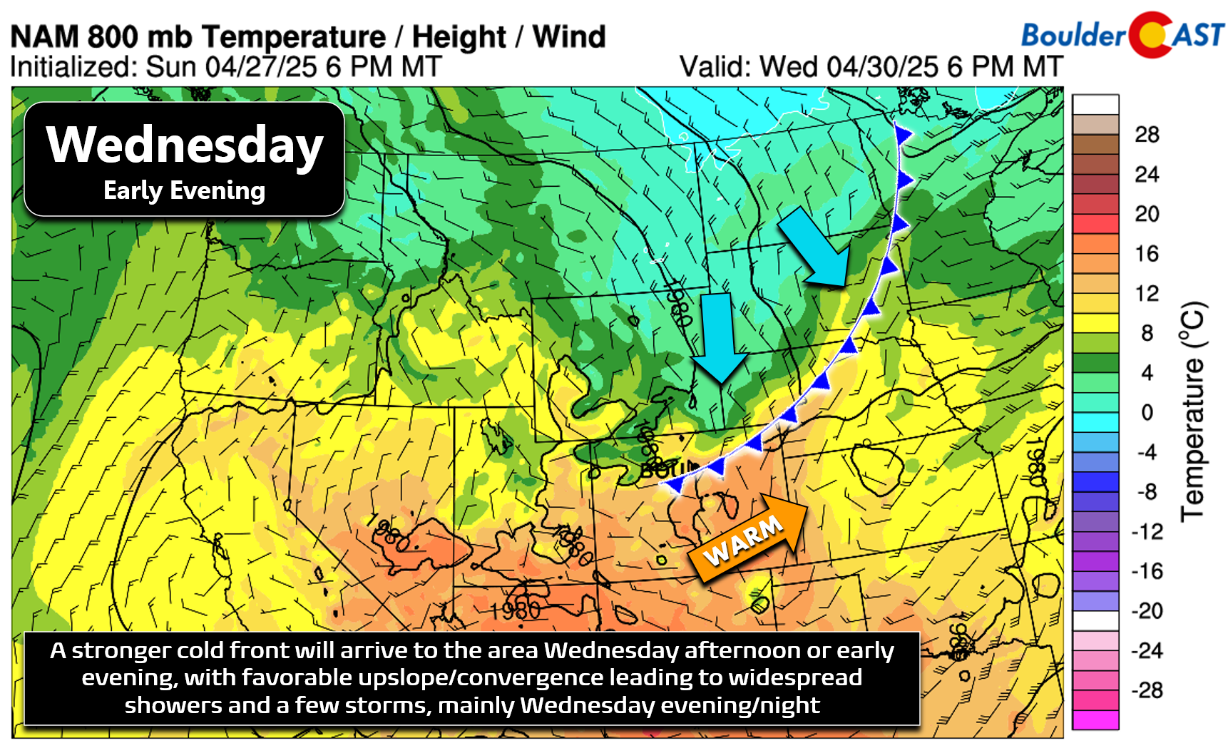
A secondary system moving along the Canadian Border around midweek will usher in a stronger cold front to the Front Range late in the day Wednesday. This front will lead to our best chance of precipitation in the extended, mainly from Wednesday evening into Thursday morning. Highs Wednesday will reach the lower 70s with increasing clouds through the day. The cold front is currently slated to move through during the late afternoon or early evening hours.
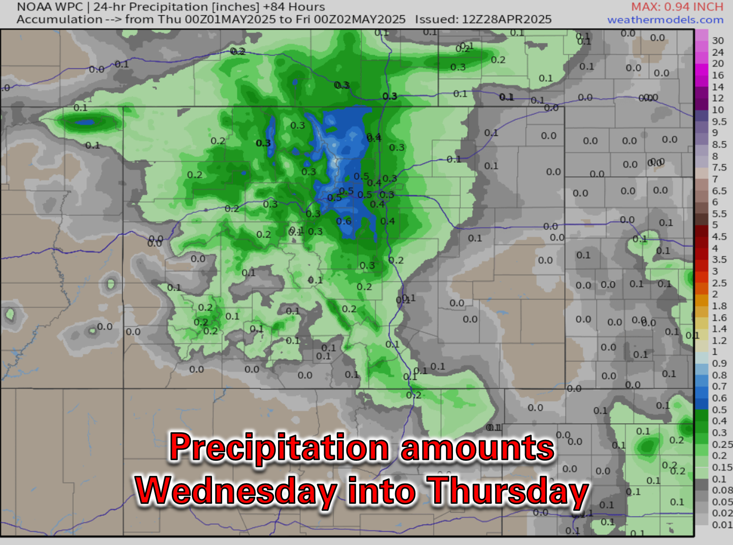
A blend of various models paints anywhere from 0.25 to 0.50″ of rain across the Boulder-Denver area behind this cold front Wednesday evening into early Thursday, with the greatest amounts in the upslope-favored Foothills and adjacent cities (Boulder included). The GFS model is currently one of the wetter solutions, with the Euro coming in somewhat drier.
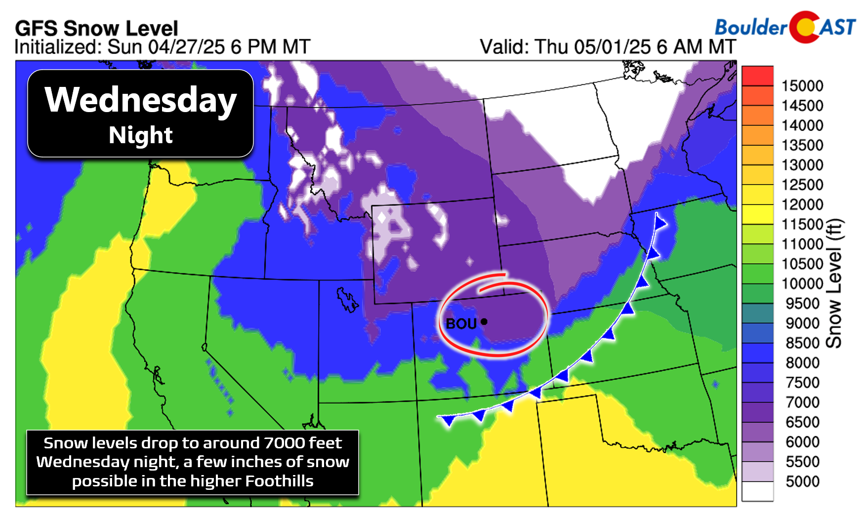
This front will have cold enough air to allow for rain to change to snow in the higher Foothills, with snow levels dropping as low 6500 to 7000 feet Wednesday night. Thus, a few slushy inches of snow would not be surprising in the higher Foothills with this system.
Low clouds and showers may still linger into the morning hours Thursday, but skies will clear to reveal some late-day sunshine. Thursday should be a much colder day with highs only in the 50s.
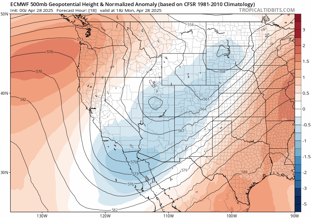
By Friday, a ridge of high pressure will be working into the region from the west and it’ll stick around into the upcoming weekend. Also note the offshore trough in the graphic below for Friday — this system will become a player for us early next week in some fashion.
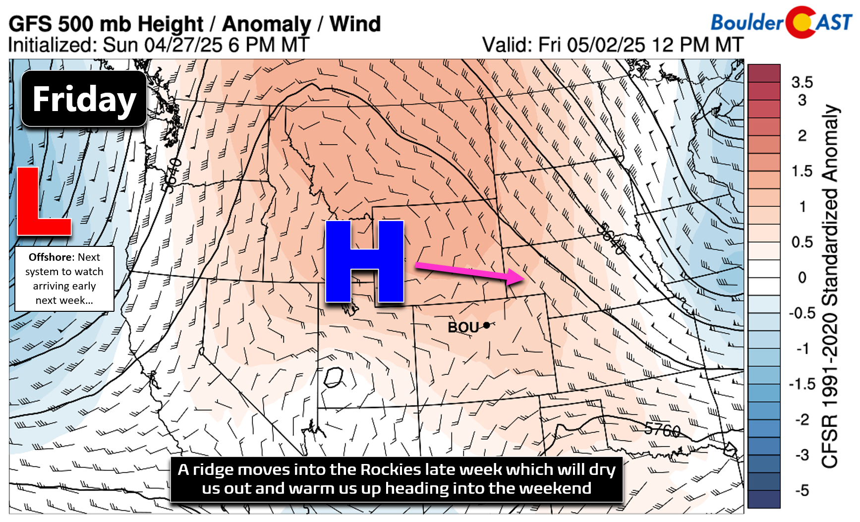
While we can’t guarantee Friday and the weekend will be completely dry, rain chances will be drastically reduced and mostly confined to a few storms across the higher terrain. Warm temperatures will return over the weekend with highs in the 70s to lower 80s.
Though still a week away, a more impressive trough coming ashore around Sunday (May 4th) or so has the potential to bring wet weather to the Four Corners or Desert Southwest early next week. Most models show some type of cut-off low forming across the southwestern United States, including the GFS model shown below:
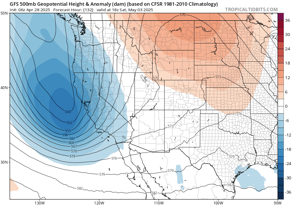
This setup could ultimately set the stage for a prolonged period of unsettled weather for us much of next week, depending upon exactly where this slow-moving low pressure tracks — it may end up diving a bit too far south.
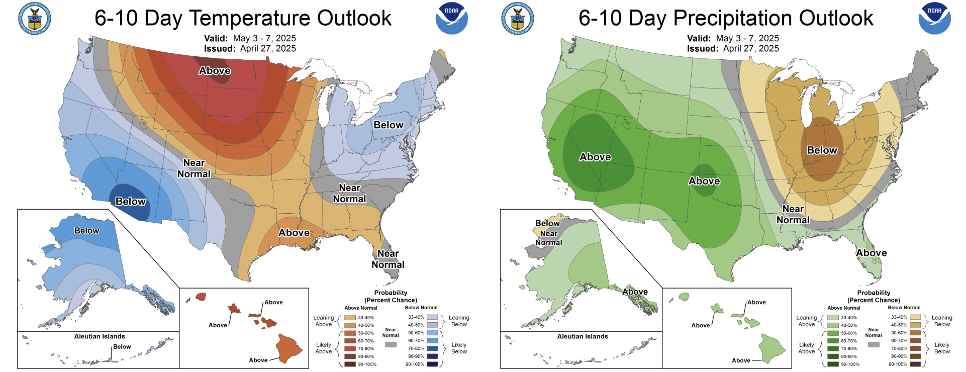
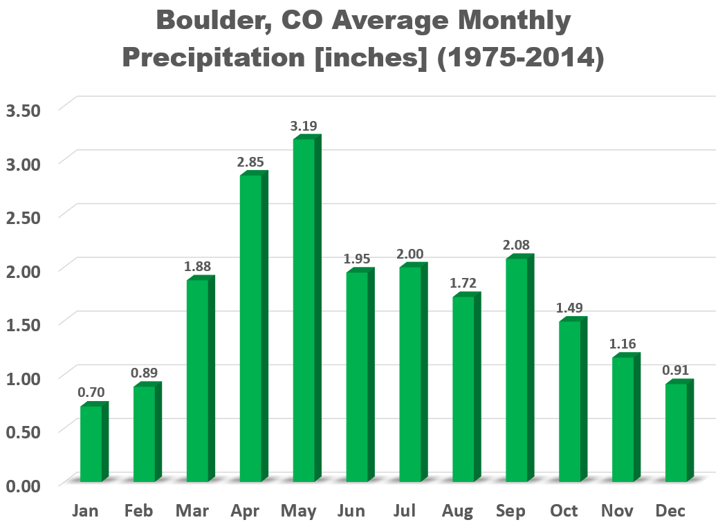
While anything that transpires next week is still quite uncertain, things are looking up for continued rain chances heading into what is typically our wettest month of the year. Huzzah!
Forecast Specifics:
Monday: Partly cloudy with a few spotty showers during the day, mainly north of Interstate 70. Highs reach the middle 60s on the Plains with lower 50s in the Foothills.
Tuesday: Morning sunshine followed by a few widely scattered thunderstorms during the late-day period. High temperatures reach the middle 60s on the Plains with lower 50s in the Foothills.
Wednesday: Some sun early, but clouds thicken through the day. A cold front will blow in during the afternoon or early evening, with showers and a few thunderstorms becoming numerous to widespread Wednesday evening and night. Precipitation will change-over to snow in the higher Foothills above 7000 feet with up to a few inches of slushy accumulation possible. High temperatures top out in the lower 70s before the cold front (upper 50s in the Foothills).
Thursday: A few lingering showers in the morning and possibly some low clouds. Skies become partly cloudy later in the day. Chilly temperatures only topping out in the 50s on the Plains with lower 40s in the Foothills.
Friday: A drier and warmer day with just a slight chance of a late-day storm, mainly across the higher terrain. Highs in the upper 60s on the Plains with middle 50s in the Foothills.
Weekend: Temperatures will trend back above normal into the 70s to lower 80s with just small chances of late-day thunderstorms.
DISCLAIMER: This weekly outlook forecast is created Monday morning and covers the entire upcoming week. Accuracy will decrease as the week progresses as this post is NOT updated. To receive daily updated forecasts from our team, among many other perks, subscribe to BoulderCAST Premium.
Go Premium, get all the perks.
Daily Forecast Updates
Get our daily forecast discussion every morning delivered to your inbox.
All Our Model Data
Access to all our Colorado-centric high-resolution weather model graphics. Seriously — every one!
Ski & Hiking Forecasts
6-day forecasts for all the Colorado ski resorts, plus more than 120 hiking trails, including every 14er.
Smoke Forecasts
Wildfire smoke concentration predictions up to 72 hours into the future.
Exclusive Content
Weekend outlooks every Thursday, bonus storm updates, historical data and much more!
No Advertisements
Enjoy ad-free viewing on the entire site.
Enjoy our content? Give it a share!


You must be logged in to post a comment.