
Our weather this week could easily be mistaken for that of early June as a prominent ridge of high pressure engulfs the entire western United States, including Colorado. There is a good chance that many Front Range cities will set a slew of new daily record high temperatures later this week, and potentially even challenge all-time monthly record highs for April. We discuss the weather pattern responsible for the unseasonable warmth and detail when cooler weather will return as it always does.
We discuss Boulder and Denver weather every single day on BoulderCAST Premium. Sign up today to get access to our daily forecast discussions every morning, complete six-day skiing and hiking forecasts powered by machine learning, access to all our Front Range specific weather models, additional storm updates and much more!

This week’s highlights include:
- A potent ridge of high pressure is the story this week, facilitating dry weather and unseasonably warm temperatures
- Record heat is possible across the Front Range Thursday and Friday with temperatures in the middle 80’s to lower 90’s
- The only chance of rain is slight and comes late in the day Friday
- Trending slightly cooler and slightly wetter for the upcoming weekend
A different flavor of weather this week…
In these weekly forecast posts that we do every Monday morning, we typically focus on troughs of low pressure that bring dynamic and active weather to the state of Colorado. Whether it be spring upslope rain, heavy snow, remnant tropical storms, bomb cyclones, monsoon thunderstorms or hurricane-force downslope winds, there’s always something to discuss with you all each and every week. This is a big part of what makes forecasting in this beautiful state such an absolute pleasure. Mother Nature is always keeping us on our toes.
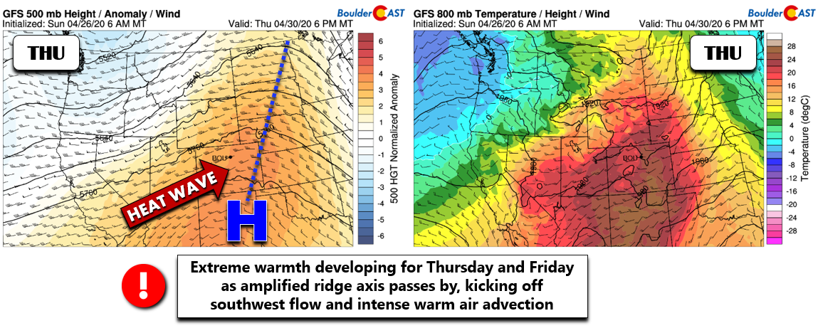
With that said, this week will certainly be a little bit different. Instead of Canadian cold fronts and turbulent jet streams, the focus will be persistent serenity and record-warm temperatures as a strong ridge of high pressure slowly builds and moves across the entire western United States. The GFS 500mb height anomaly forecast animation below shows the developing ridge that will be a mainstay for us this week. This animation ends on Saturday.
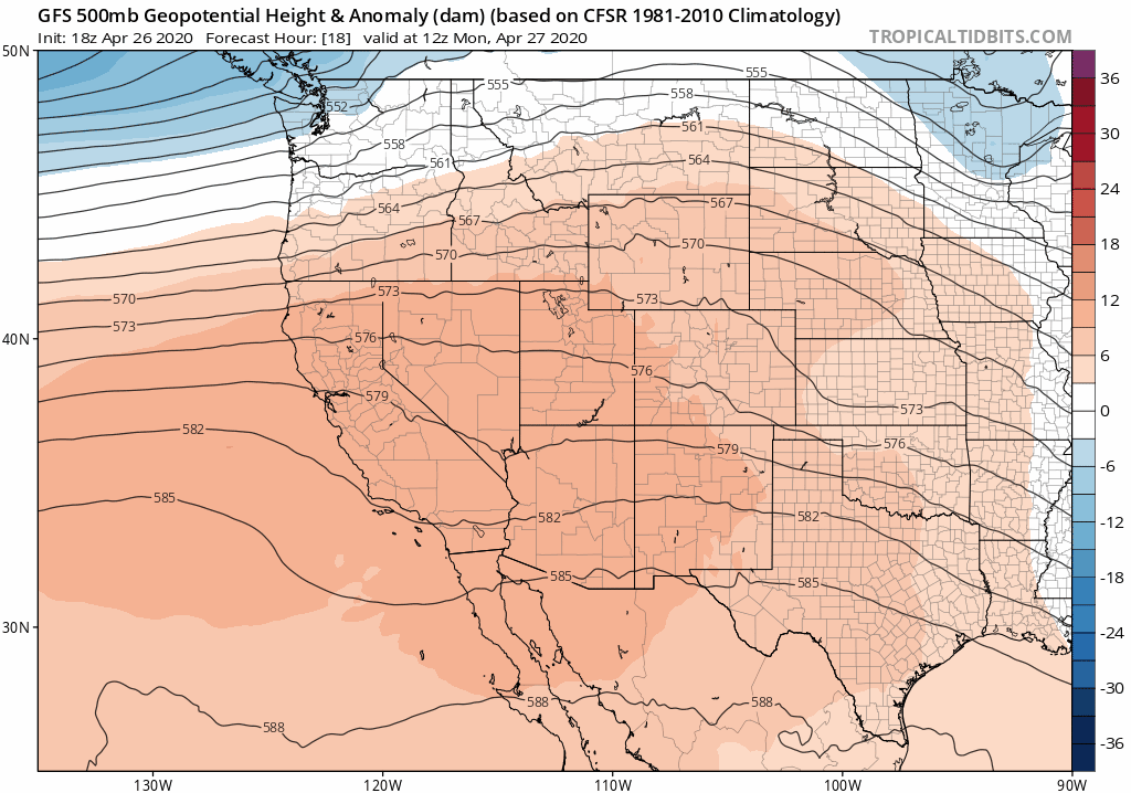
GFS 500mb height anomaly forecast animation for the western United States from Monday through Saturday showing the intense ridge moving through our area
The eastern Pacific Ocean made history this past weekend with the formation of Tropical Depression One-E, the earliest tropical system ever recorded in the ocean basin. The premature depression developed about 800 miles off the southwestern coast of Mexico. How is this relevant to our weather? Well, this extremely early tropical system was made possible by warm sea-surface temperatures and weakened winds aloft near the center of the aforementioned ridge in the eastern Pacific. This should give you an idea of the magnitude of what we will be dealing with this week as the very same high pressure engulfs the Rockies.
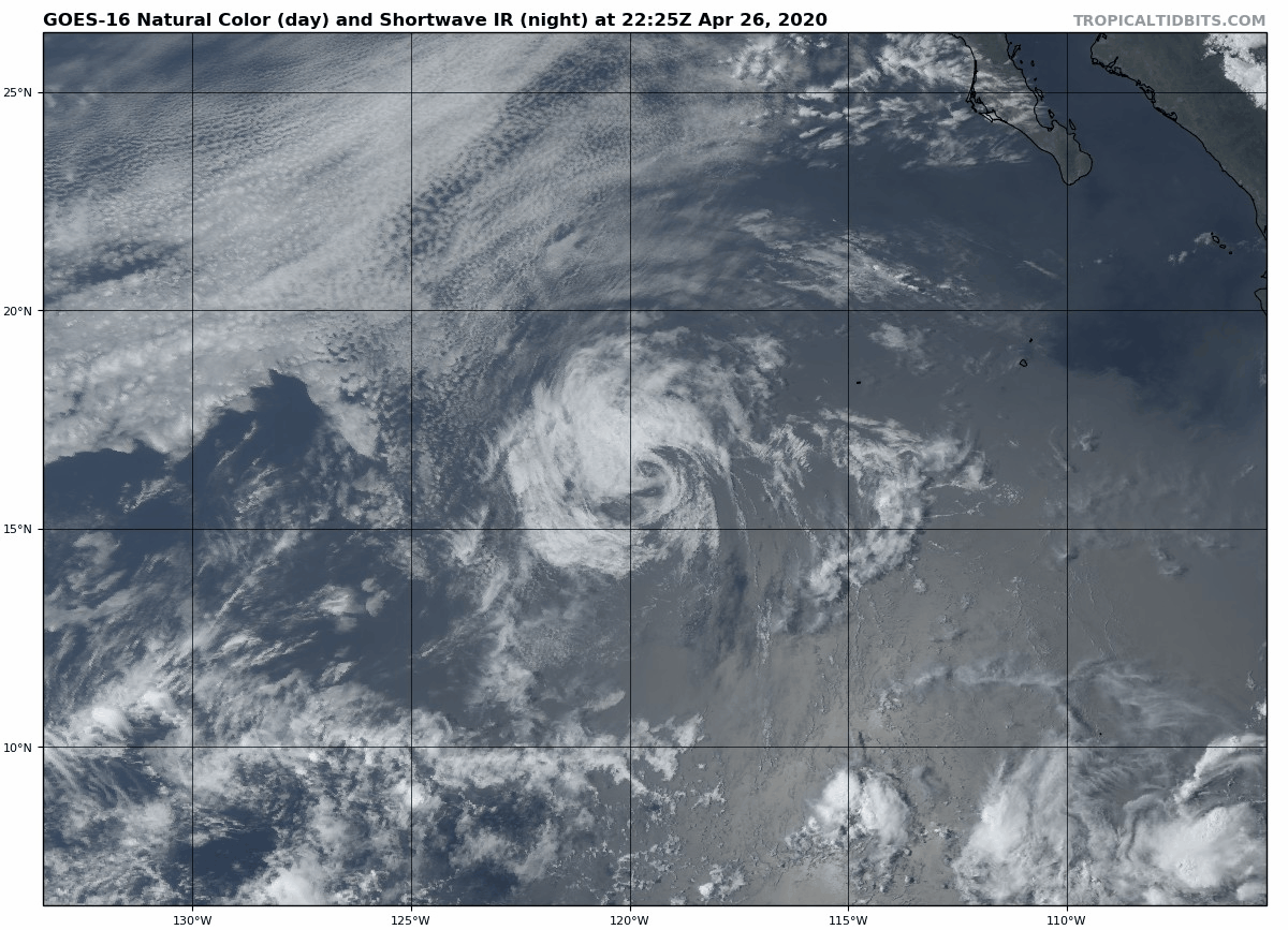
GOES-East satellite animation from Sunday evening of Post-Tropical Cyclone One-E off the coast of Mexico
Colorado will reside east of the ridge axis Monday and Tuesday under northwest flow, in the heart of the ridge Wednesday and Thursday with weak westerly flow, and then transition west of the ridge axis Thursday and beyond. It’s not until very late into the week or the weekend that we’ll see chances for precipitation return to the state with an increase of moisture accompanying a southwesterly wind shift.
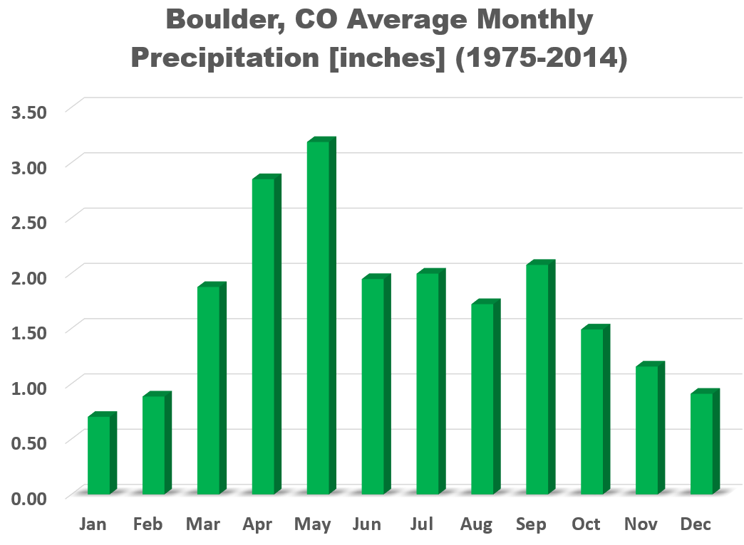
As it stands, this week will perpetuate a streak of dry weather at least seven days long (April 24th to May 1st). While not impossible per se, it is rather uncommon. Mid-April through mid-May is typically our wettest and gloomiest time the year here in the Front Range. It’s the precipitation that we get now that keeps things green into early summer and sets the tone for the fire season to come. As much as we all enjoy the kindness from Mother Nature given the cold and snow April we’ve recently experienced, it needs to be relatively short-lived to maintain good hydrology for the area moving forward.
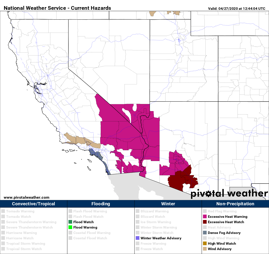
Accompanying the dry conditions this week will be unseasonably warm temperatures for the region. One only has to glance briefly to the west to see what is headed our way. A handful of Excessive Heat Watches and Warnings are already in effect across portions of the Desert Southwest.
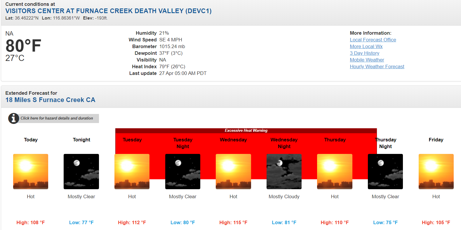
Death Valley in California, the hottest place in the United States, is indeed poised to have a very toasty week! The forecast high of 115°F on Wednesday would be a new all-time maximum temperature for the month of April!
For the Denver Metro area, Monday through Wednesday will be in the 70’s under generally mostly sunny skies. The “extreme” heat ramps up Thursday as the core of the ridge moves overhead and southwest flow kicks in. The final day of April is the one to watch for potential all-time monthly record highs in our area, too. The warmest of the airmass is expected to be overhead Thursday into Friday. Denver and Boulder could be flirting with the 90-degree mark.
While far from certain due to potentially widespread cloud cover, if we do hit 90°F on Thursday in Boulder, it will be…
- A new daily record high for April 30th (current record is 87°F from 1992)
- An new all-time record high temperature for the month of April (current record is 88°F from April 21, 1989)
- The earliest 90-degree day on record (current record is May 15 from 1978)
Friday is expected to stay hot in the mid to upper 80’s, but also bolster a slight chance of late-day thunderstorms. Chances look very slim at the moment, but the exact forecast for late-week may change slightly between now and then. As of now, the GFS model is showing isolated to scattered showers for portions of northern Colorado Friday afternoon and evening (see below). Most of us, though, will likely close out the week just as it started: dry and warm.
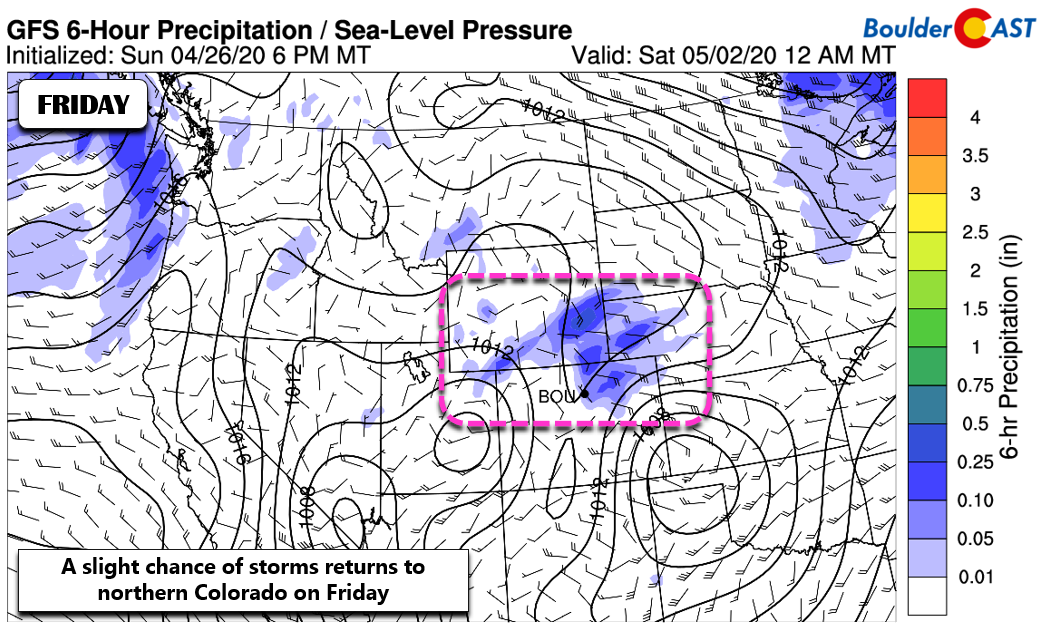
As we head into the weekend, a larger trough will begin to come ashore into the Pacific Northwest. Ahead of this, moisture-rich and at times turbulent southwesterly flow will influence Colorado. While temperatures will likely stay well above normal in the 70’s for us, a better chance of storms will take hold across the area. This setup is one we will need to watch for severe weather as well. It’s more typical for the end of May, not the beginning.
Enjoy the week ahead…it’s being cut right from the very fabric of summer!
Forecast Specifics:
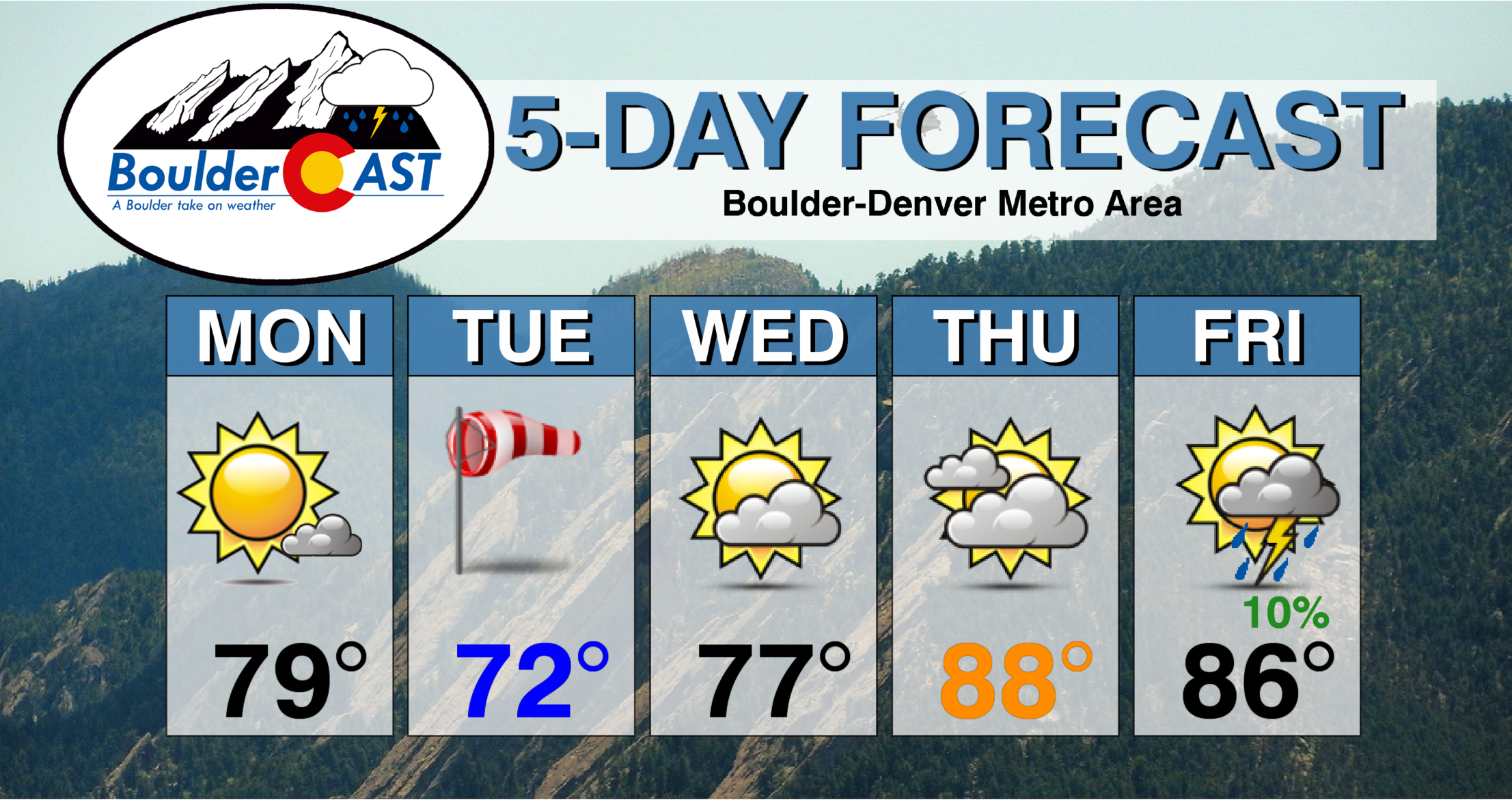
Monday: Mostly sunny and warm. Highs in the upper 70’s on the Plains and middle 60’s in the Foothills.
Tuesday: Partly to mostly sunny and slightly cooler following a weak cold front. Breezy conditions are expected from late morning through the afternoon with gusts up to 25 MPH. Highs in the low to middle 70’s on the Plains and lower 60’s over the Foothills.
Wednesday: Mostly sunny with a few late day clouds. Highs in the upper 70’s on the Plains and middle 60’s in the Foothills.
Thursday: Partly to mostly cloudy with near-record heat possible. Highs in the upper 80’s to near 90 degrees on the Plains and middle 70’s in the Foothills.
Friday: Partly cloudy and hot with a very slight chance of late day thunderstorms. Highs in the mid to upper 80’s on the Plains and middle 70’s in the Foothills.
The Weekend: The ridge heads slightly east with a new trough coming ashore into the Pacific Northwest. Our weather will turn cooler into the 70’s with slightly better chances for storms.
High Country: Light winds, dry weather, and above normal temperatures will be the story in the Mountains this week as well. There are no real chances for rain/storms in the Mountains until the weekend when we may see a return of scattered showers and storms. Check SummitCAST for daily updated forecasts for more than 120 mountain hiking destinations across Colorado.
We discuss Boulder and Denver weather every single day on BoulderCAST Premium. Sign up today to get access to our daily forecast discussions every morning, complete six-day skiing and hiking forecasts powered by machine learning, access to all our Front Range specific weather models, additional storm updates and much more!
.
Spread the word, share the BoulderCAST forecast!


You must be logged in to post a comment.