After a round of light rain and snow overnight, quiet weather will ensue for the Front Range through midweek with limited chances for rainfall and temperatures trending upwards. However, our main focus is towards a soggy late-week storm system which will bring widespread rain and snow to the area. While still somewhat uncertain, several inches of spring snow are looking increasingly likely for us, even across the lower elevations. Read on for all the details.
This week’s highlights include:
- Cool & Sunny Monday: Lingering snow quickly ends Monday early morning, with sunshine and cool temperatures for the rest of the day
- Limited Precipitation through Midweek: Precipitation is limited through midweek, but isolated showers or a storm will be possible late Tuesday and Wednesday afternoons
- Late-Week Spring Soaker Brewing? A late-week storm system will usher in excellent chances for precipitation late Thursday into Saturday with a mix of rain and snow favored. Wet snow accumulations appear likely, even for the lower elevations, with upwards of 1″ of moisture headed our way!
- Temperatures: Soaring well into the 70s several days around midweek, then turning much colder for Friday into the weekend ahead.
DISCLAIMER: This weekly outlook forecast is created Monday morning and covers the entire upcoming week. Accuracy will decrease as the week progresses as this post is NOT updated. To receive daily updated forecasts from our team, among many other perks, subscribe to BoulderCAST Premium.

Go Premium, get all the perks.
Daily Forecast Updates
Get our daily forecast discussion every morning delivered to your inbox.
All Our Model Data
Access to all our Colorado-centric high-resolution weather model graphics. Seriously — every one!
Ski & Hiking Forecasts
6-day forecasts for all the Colorado ski resorts, plus more than 120 hiking trails, including every 14er.
Smoke Forecasts
Wildfire smoke concentration predictions up to 72 hours into the future.
Exclusive Content
Weekend outlooks every Thursday, bonus storm updates, historical data and much more!
No Advertisements
Enjoy ad-free viewing on the entire site.
Warming up into midweek & watching a late-week soggy storm
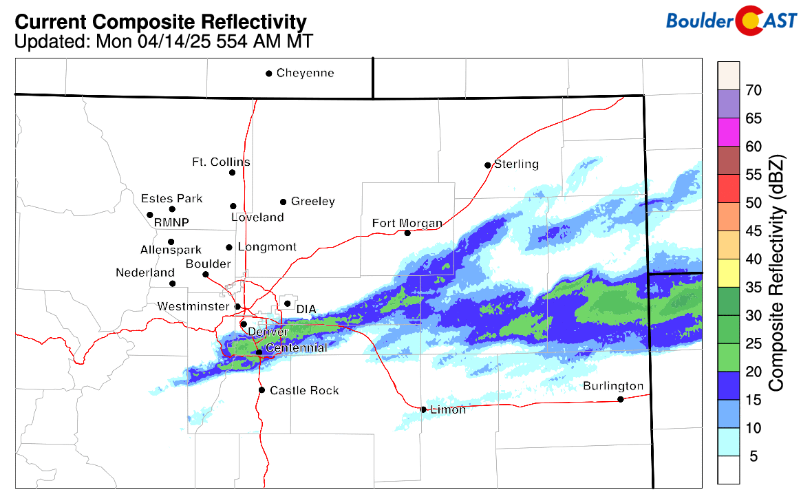
The last of the spotty jet-forced bands of precipitation are coming quickly to an end across the Front Range early Monday morning, tracking along with the jet stream off to the southeast. Most of the area saw preciptiation begin as light rain Sunday evening (with a few rumbles of thunder) before changing to snow overnight.
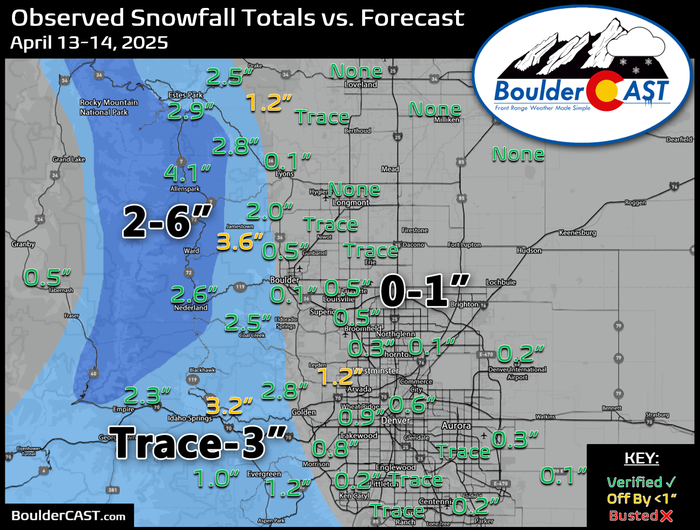
Our snowfall forecast map issued Sunday morning is shown below with storm totals overlaid. Green values indicate our forecast verified, Yellow values mean the observed total was just outside our forecast, while Red was a busted forecast (more than 1″ off). In general, most of the lower elevations in the Metro area picked up a trace to 1″ of snow on the grass overnight, while 1 to 4 inches accumulated in the higher terrain.
Quiet weather will take hold for the remainder of our Monday. Below shows the pattern across the United States. A cold front from last night will continue to push off to the south and east over Texas, Missouri, and the Great Lakes as low pressure moves into eastern Canada. High pressure will build in this afternoon over the Front Range with morning gloom quickly turning sunny before lunchtime!
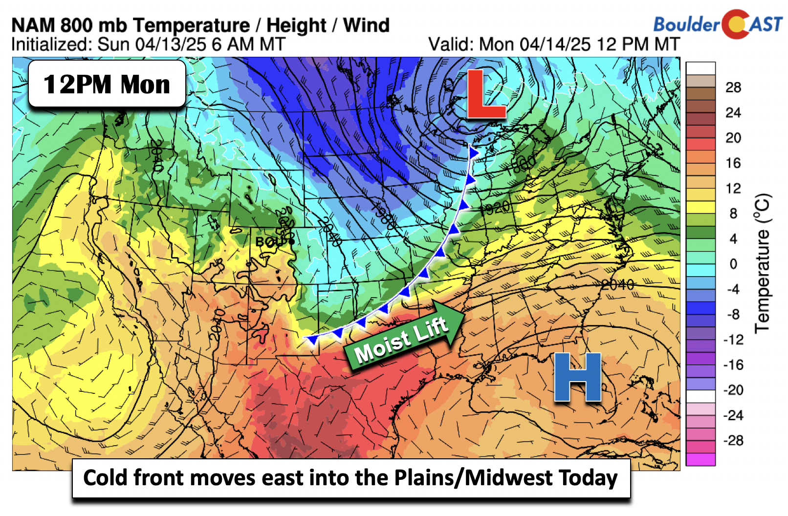
We will be near normal for high temperatures on Monday in the upper 50s with the cooler airmass in place — a far cry from the summerlike 70s and 80s we’ve seen the last few days!
At the mid-levels Monday, we see a shortwave over the Great Lakes which is tied to the cold front mentioned earlier. We are watching two offshore systems near the Baja. One of these southern-track systems will reach portions of our area Tuesday into Wednesday, but it will weaken as it runs into ridging building southeast from the Pacific Northwest at the same time.
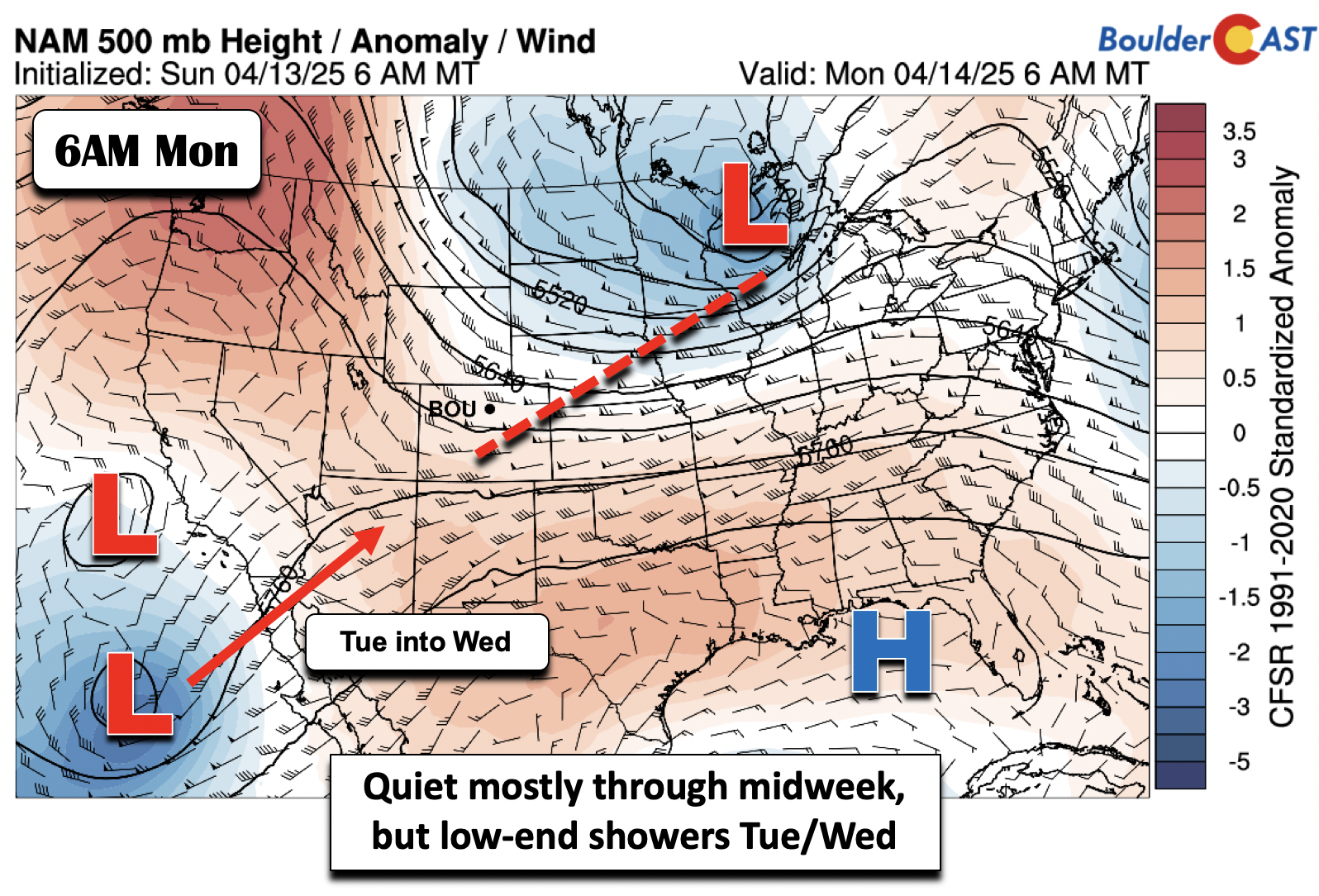
These systems will send energy into the Desert Southwest and Colorado from late Tuesday through late Wednesday. This energy won’t do much for the Plains, but we will discuss that shortly.
Very warm temperatures will set in by midweek under the ridging pushing into Colorado and much of the Intermountain West. Temperature anomalies Wednesday will approach some 2 to 3 standard deviations above climatology. Lower 70s Tuesday are expected, followed by mid to upper 70s heading into Wednesday and Thursday.
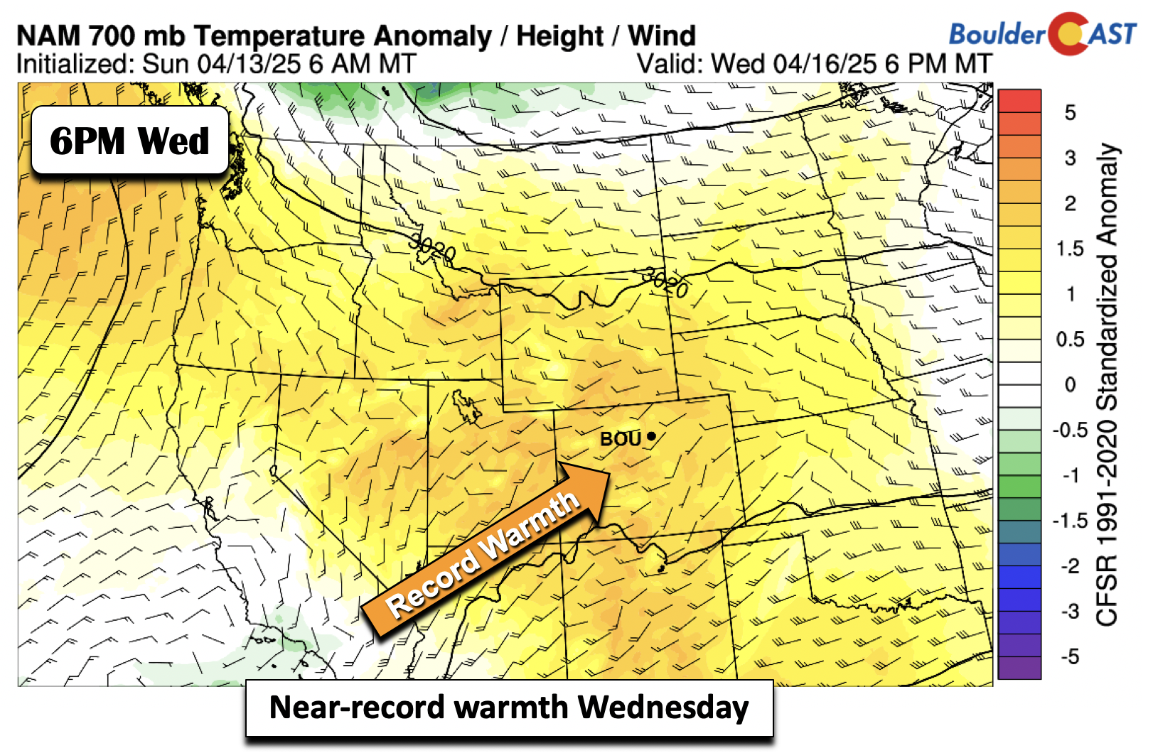
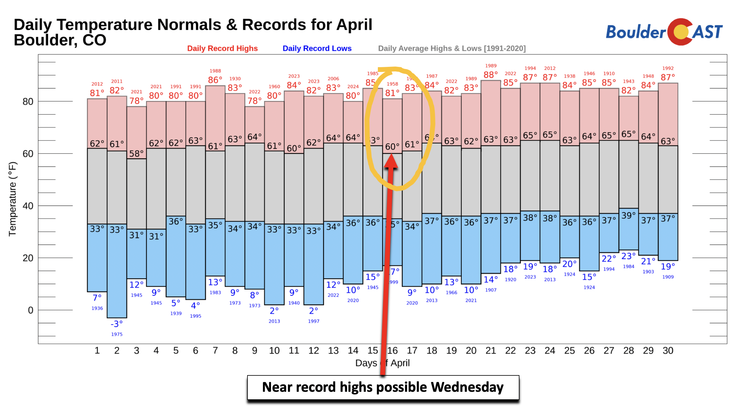
On Wednesday, the record high for Boulder is 81°F set in 1958, so if things trend a tad warmer, this could be in jeopardy.
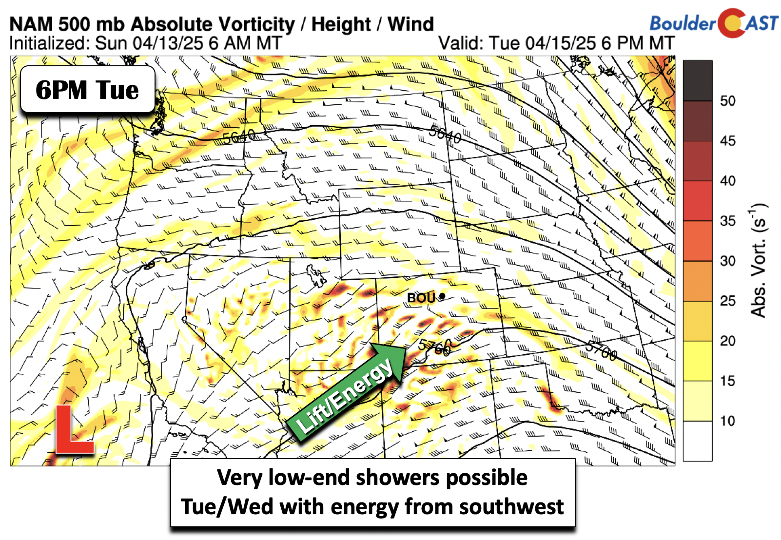
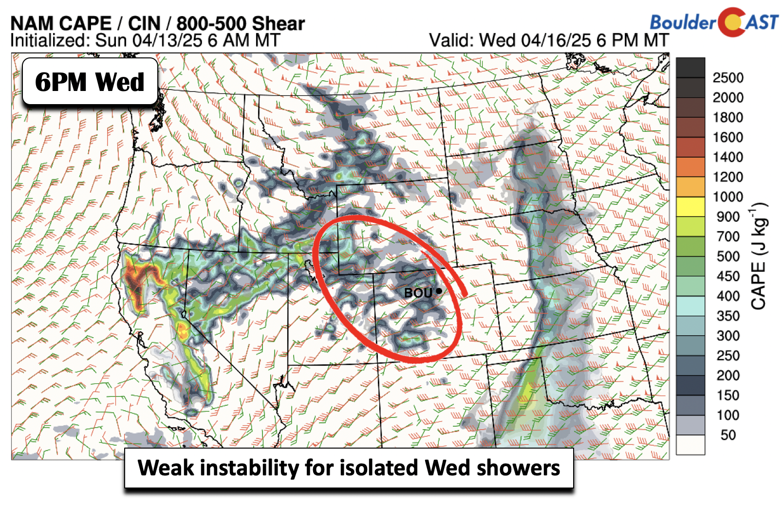
A few instability showers during the afternoons of Tuesday and Wednesday will warrant a 5 to 20% chance of precipitation. We cannot rule out an isolated thunderstorm on Wednesday as well with instability of 500 J/kg or less and weak to moderate shear of 20-30 knots.
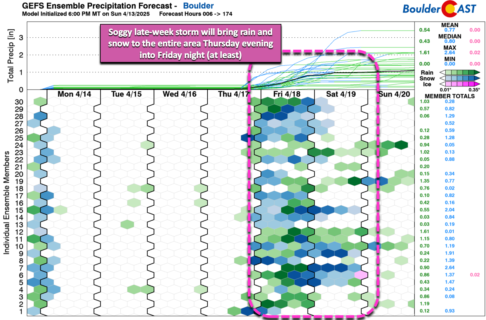
The rain chances to start the week are minimal — most of our time will be dry. We are watching a more impressive storm system taking aim on Colorado from sometime late Thursday, possibly lingering around through the weekend. GEFS ensemble members show quite the spread but do indicate very high chances of precipitation for our entire area, with temperatures likely getting cold enough for accumulating snow. The ensemble mean is around 1″ of precipitation for Boulder late-week, so this storm definitely bears watching!
The two shortwave troughs over the Baja on Monday are forecast to partially or completely merge with a southward penetrating trough from Montana and Canada later this week. How these three systems conglomerate together is unclear at this point. The ensemble cluster solutions are shown below. The first two solutions show a deepening trough near the Great Basin, but with the southern stream wave trying to partially merge with the northern system. The last few clusters show limited interaction and with just a simple trough axis pushing through. This is for late Thursday.
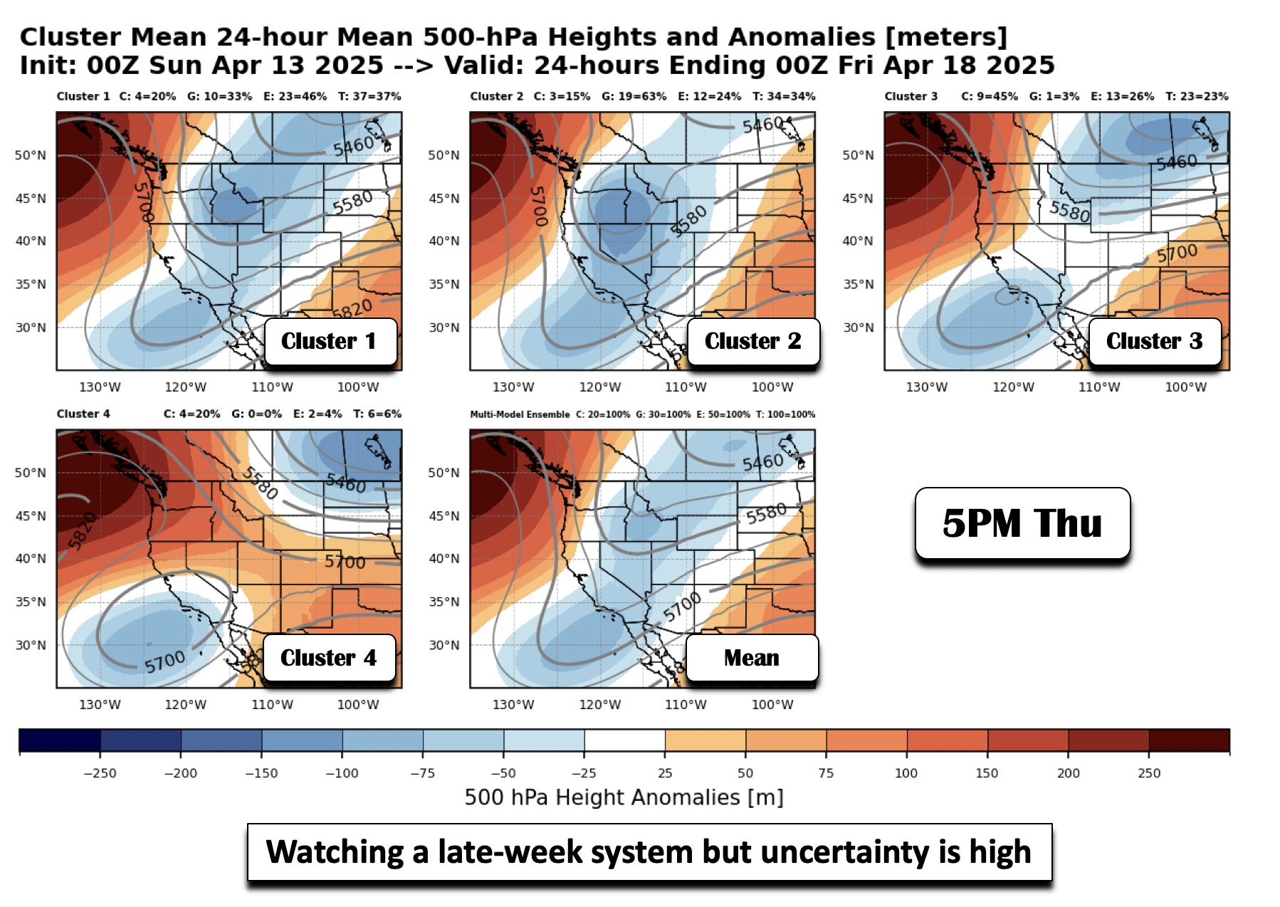
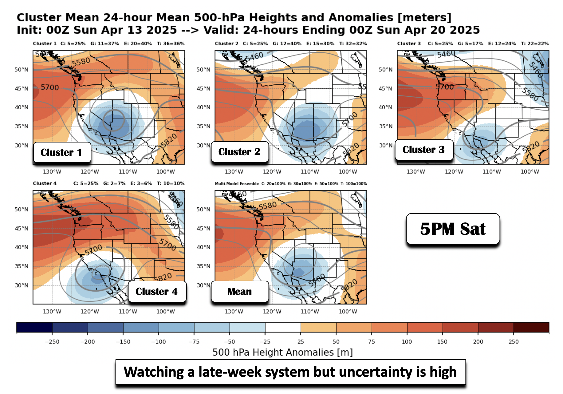
By Saturday, the first two possible scenarios show a closed low near the Four Corners, while the last two solutions indicate a further southward low over Arizona or Baja. Obviously the first two outcomes with a Four Corners Low would favor our area the most for widespread, soaking precipitation. All in all, we’re seeing too much uncertainty to make a high-confidence forecast this far out. Regardless of the scenario, all models agree on a cold front coming in Thursday night, which should turn our temperatures well below average heading into the weekend.
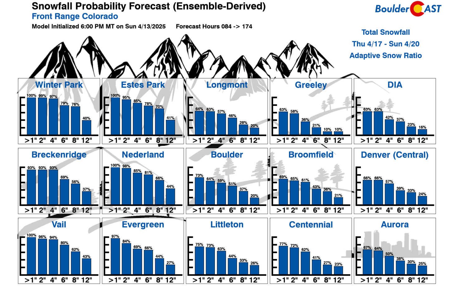
As mentioned, the ensemble mean is close to 1″ of precipitation late week in Boulder, with a good chance that rain will change-over to snow. Our latest Snowfall Probabilities for the late-week system favor wet snow accumulations in the 3 to 6 inch range for Boulder and Denver. That’s not our official forecast just yet, but do know there is a strong likelihood of accumulating snow returning to the area by the end of the week — nothing out of the ordinary for spring in Colorado of course!
The first four days of the week are pretty nice. It’s really just Friday shaping up to be a rainy/snowy mess. Stay tuned for updates on the impending wintry weather through the week and be sure to follow us on Twitter, Bluesky, Facebook, and Threads for impromptu weather updates in the coming days, or subscribe to get notified of our long-form updates here.
Forecast Specifics:
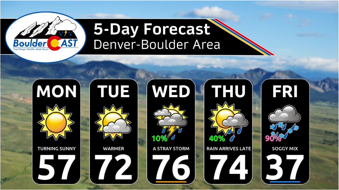
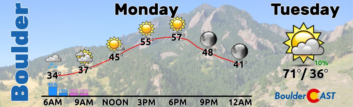
Monday: Morning clouds will clear quickly. Then sunny and quiet with temperatures near normal in the upper 50s on the Plains with mid 40s in the snowy Foothills.
Tuesday: Partly sunny with a 10% chance of a late-day shower, mostly south of Denver. Otherwise warmer with low 70s on the Plains and upper 50s in the Foothills.
Wednesday: Partly to mostly cloudy with a 20% chance of an isolated shower/storm. Highs in the mid to upper 70s on the Plains with lower 60s in the Foothills.
Thursday: Partly to mostly sunny with mid 70s on the Plains and lower 60s in the Foothills. There will be a chance of late-day showers or a mix of snow in the higher Foothills Thursday night. The lower elevations probably also change-over to snow Thursday night sometime or on Friday.
Friday: Mostly cloudy with a good chance for rain/snow through the day. Some accumulation is favored, even for the lower elevations. Highs much cooler in the 30s for the Plains and 20s for the Foothills.
Weekend: Staying below normal for the weekend along with unsettled weather lingering in the form of rain and snow. Confidence on specifics is low at this point, but it’s definitely not going to be another beautiful weekend like we just had — that’s for sure!
Get BoulderCAST updates delivered to your inbox:
DISCLAIMER: This weekly outlook forecast is created Monday morning and covers the entire upcoming week. Accuracy will decrease as the week progresses as this post is NOT updated. To receive daily updated forecasts from our team, among many other perks, subscribe to BoulderCAST Premium.
Go Premium, get all the perks.
Daily Forecast Updates
Get our daily forecast discussion every morning delivered to your inbox.
All Our Model Data
Access to all our Colorado-centric high-resolution weather model graphics. Seriously — every one!
Ski & Hiking Forecasts
6-day forecasts for all the Colorado ski resorts, plus more than 120 hiking trails, including every 14er.
Smoke Forecasts
Wildfire smoke concentration predictions up to 72 hours into the future.
Exclusive Content
Weekend outlooks every Thursday, bonus storm updates, historical data and much more!
No Advertisements
Enjoy ad-free viewing on the entire site.
Enjoy our content? Give it a share!


You must be logged in to post a comment.