


We begin the week under the protective influence of a mid-level ridge of high pressure. With this, the Front Range will be (mostly) dry and at times very warm through the week. Read on for our short and to-the-point weekly outlook.
Tag: winter (Page 5 of 16)
A quick update on today’s weather as a cold front arrives later this morning bringing snow to the region. Model disagreements, even in this final hour, leave some uncertainty into how much snow may fall. Read on for all the details.

Following month after month of dry and warm weather, December finally turned the tide and brought colder and snowier conditions to the region. Will January continue the trend? Read on as we examine Boulder’s climatology and consider the current state of the atmosphere to give our outlook for the next month.

Get ready for a cold week! After relatively mild temperatures to end 2016, we’ll see the return of the winter chill along with chances for snow in the first week of the New Year. The mountains can expect to see FEET of snow throughout the week, while snow possibilities on the Plains are less and shrouded in a bit of late-week uncertainty. How cold will it get and what can we expect in terms of snow? Read on for our full forecast.
We hope you had a safe and festive holiday weekend! Please excuse the brevity of this week’s forecast. Overall, we’re not expecting much in the way of interesting or impactful weather this week anyways. Dry and warm conditions will prevail through Friday, with snow potentially arriving for the weekend and into early next week. Read on for our short and sweet outlook covering the upcoming week.
After polar air and snow this past weekend, a very nice warm up is in store for the first few days of the week. Overall, expect a rather benign week but the High Country should see more snowfall. In the extended, we’re watching a potential snow storm Christmas Eve/Christmas Day. We’ll discuss that and the week ahead. Read on to find out more.
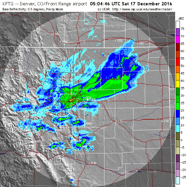
Thanks to a stationary band of heavy snow Friday night, many of you may have awoken to more snow than expected. We explain what happened overnight to produce 5-10″ of snow in parts of the Denver Metro area and also detail when we expect the Arctic chill to retreat.
Live Radar

Trending Content


Recent Premium Posts

BoulderCAST Daily – Sat 11/14/26 | A Pair of Foggy Mornings With Little Rain
🌫️ A Pair of Foggy Mornings — Moisture banked up along the Foothills …
BoulderCAST Daily – Fri 11/13/26 | Quiet Today But Turning Unsettled Tomorrow
☀️ Quiet Today — Sunshine and low to middle 60s across the Front …
This Weekend in Colorado Weather: The Quiet Pattern Ends as Storm Activity Picks Up Across the West
After weeks of sunshine, mild afternoons, and storm systems repeatedly missing Colorado to …
© 2026 Front Range Weather, LLC