The next few days will solidify the rest of the country’s belief that our weather here is pure insanity. We provide an update on what is shaping-up to be an historic late-season winter storm for the Front Range Foothills. The potential for accumulating snow across the lower elevations is much more uncertain at this time. Read on for the latest details…
Update (7:00 AM Thursday): Read our latest forecast HERE.
As we mentioned in our weekly outlook on Monday (and reiterated in yesterday’s Premium forecast), the storm in question will be a doozy! Models have shown relatively good agreement over the last 36 hours or so. Confidence is growing that something special is headed to our region! A spectacular cut-off low pressure system is set to move into Colorado later tonight. Upslope, upper-level lift, and moisture will combine to produce a prolonged period of widespread precipitation for our region as the storm stalls across the state Thursday and Friday.
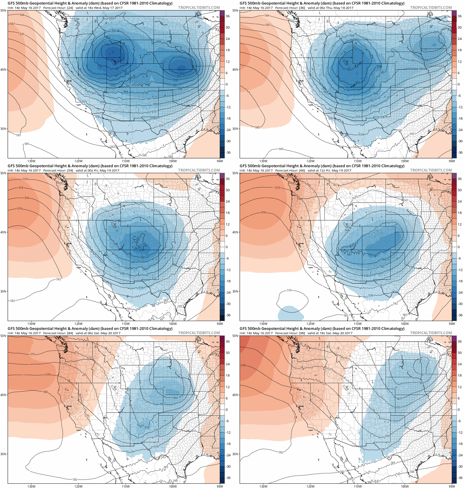
GFS 500 mb height animation showing the storm moving into Colorado and stalling Thursday night and Friday.
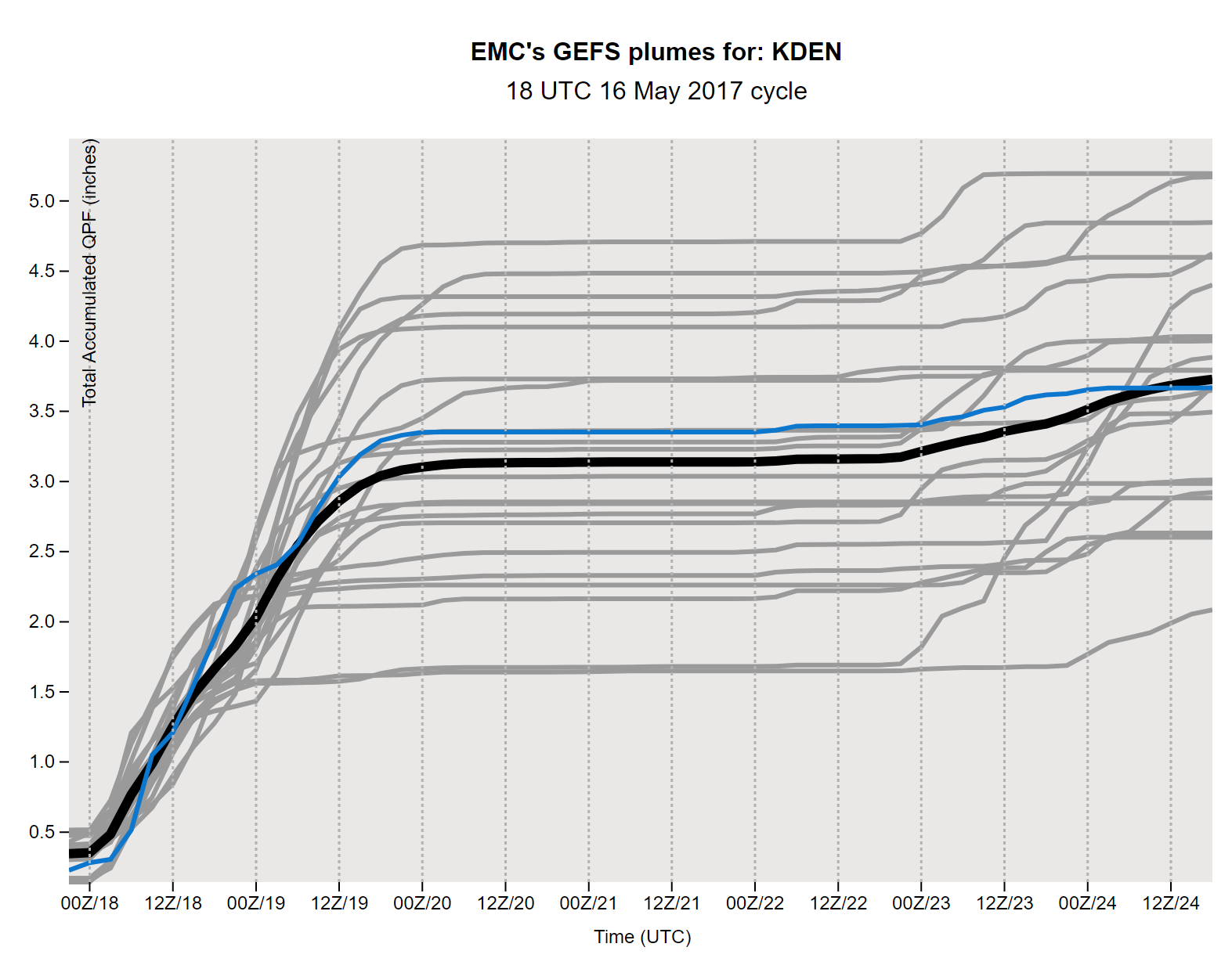
The GFS ensemble plumes have a mean and median total liquid forecast of right around 3 inches for Denver (shown below), Greeley, and Cheyenne. While the GFS model has had a rough go this winter across our region, we think that it’s spot on this time.
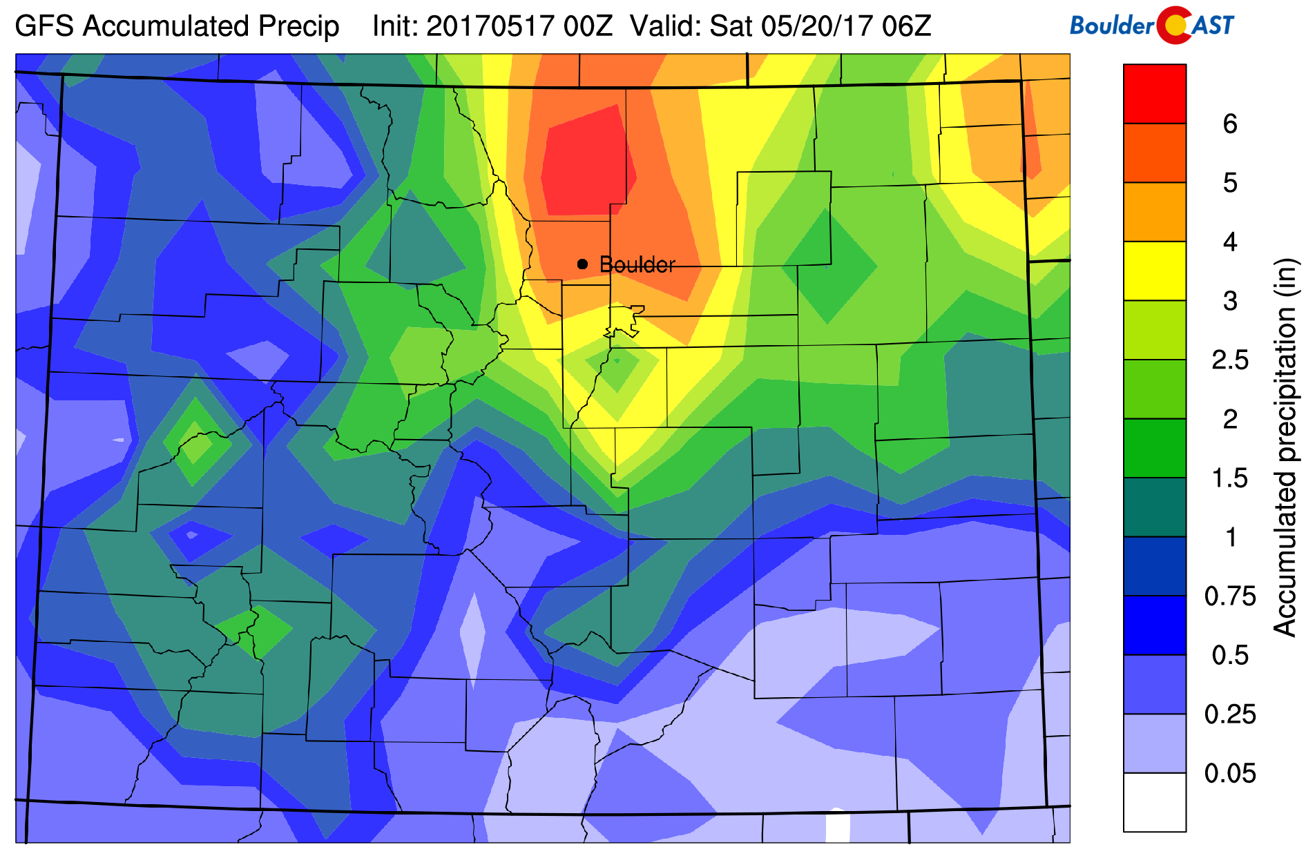
The latest operational GFS run produces jokingly-large precipitation totals in excess of 7″ in Larimer County, with 2-5″ across Denver and Boulder.
The Canadian and European models are in close agreement with the GFS right now, while the NAM has had the pesky habit of keeping the storm just a hair too far north. As you can see below, this slight track difference drastically changes the wind pattern of the Denver Metro area from upslope to downslope (click the image to enlarge). While confidence in how things will play out over the next 72 hours is higher-than-one-might-expect-for-a-mid-May-snowstorm, there are no guarantees. There is plenty of room for things to go astray.
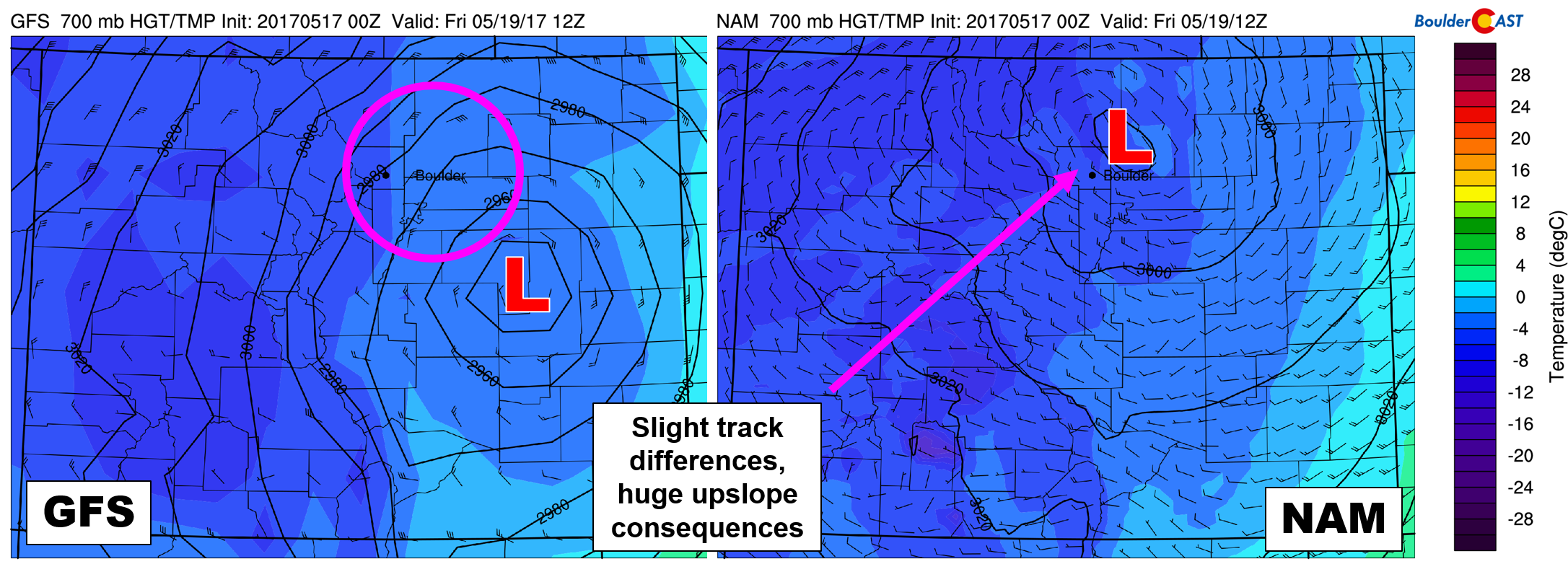
Model differences in storm track could have big implications on upslope potential across the Denver Metro.
And yes, that is 40 knot northeasterly upslope being predicted in Boulder Friday morning by the GFS!
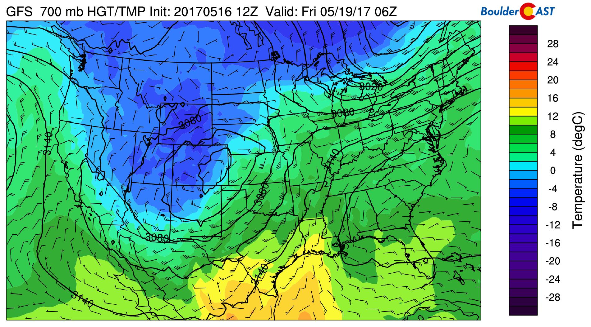
With a fair chance of hefty precipitation amounts in the pipeline, a little cold air could go a LONG way towards turning this into a blizzard of historical magnitude. This is exactly what models are predicting for the Foothills. Unseasonably cold air will accompany our storm to produce MASSIVE snowfall totals in the Foothills west of town. Many areas will be measuring the white stuff by the foot. The 700 mb map below for Thursday night shows temperatures around -5 degrees Celsius across the region. While not quite as cold as our last snow event in late April, it’s just dandy to keep things mostly snow in the Foothills above 7,000 feet.
These temperatures are marginal to support snow across the lower elevations Thursday night and Friday morning. If you read our outlook for May, this should be no surprise! Snow has been recorded in the month of May 15 of the last 18 years in Boulder. We’re going to go out on a (questionably sturdy) limb and check-off 2017 to make it 16 of the last 19 years. Since the late 1800’s, only five storms have produced accumulating snow later in the year than this storm could for Boulder.
On paper, this storm bears a lot of similarities to the historic Front Range blizzard that occurred just over one year ago in April 2016. Remember…this one? Nearly 20 inches of snow was recorded in Boulder, a foot in Denver, and up to 50 (FIFTY!) inches in the Foothills. While the upcoming storm isn’t advertised to be as cold, we should still see SOME snow in parts of the Denver Metro area…
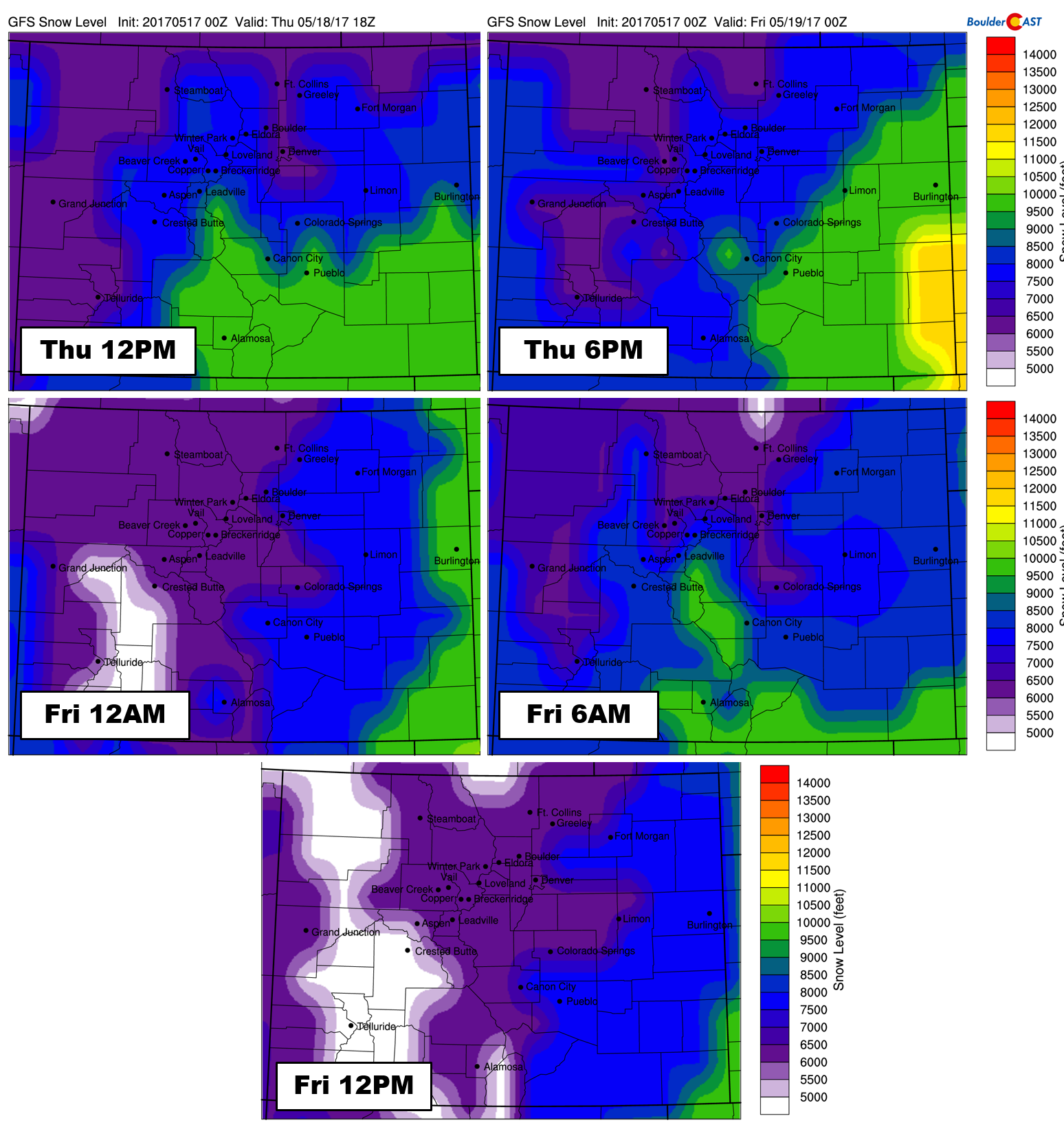
Snow levels will fall from around 7,500 feet Thursday morning towards 6,000 feet by Thursday evening:
With more and more cooling in the mid and lower levels of the atmosphere, rain could mix with and change to snow in and around Denver/Boulder late Thursday night or early Friday. However, with temperatures likely bottoming out in the middle 30’s for most locations, winter’s impacts will be minimal across the Plains. Any accumulation on road surfaces is highly unlikely.
TIMELINE:
Highs today will range from the mid 60’s to near 70 degrees. Rain chances (and a few storms) will increase later this afternoon and evening. A fierce cold front will move through around sunset tonight, lowering snow levels and increasing precipitation coverage across the region. The higher Foothills above 9,000 feet will see snow much of the night, with the mid-Foothills (down to about 7,500 feet) changing over by mid-morning Thursday. Widespread moderate precipitation will continue through the day Thursday. We hope you don’t have any outdoor plans. This precipitation will be all rain on the Plains, but mostly snow in the Foothills above 7,000 feet. Eventually Thursday night, some snow could mix in across the Plains as well. Rain and snow will continue into Friday afternoon (unless you believe the NAM model, in which case it ends much earlier). Messy is an understatement for this forecast.
SNOW AMOUNTS:
We’re expecting liquid totals to range from 1.5 to 3.5 inches across the region….
- In the higher Foothills above 9,000 feet, this will be all snow, so expect 20 to 40″ to pile up by late Friday night. Totals in excess of 4 feet are not out of the question, especially in northern Boulder County and Larimer County.
- In the mid-Foothills, some rain early-on will lower totals, but prime upslope conditions Thursday night and early Friday could make up for this. 15 to 30″ is entirely possible for elevations between 7,500 and 9,000 feet.
- The lower Foothills between 6,000 and 7,500 feet have the biggest chance to bust in our opinion. This area will likely host the rain/snow line for much of the event. With that said, the large range of 6-18″ is our projection for now. This can hopefully get ironed out in the next 24 hours. Trees with advanced leafage may overlap with heavy wet snow in this zone causing power outages and downed trees.
- On the Plains, as always, uncertainty is high as well…Not for historic snow amounts, but for ANY accumulating snow at all. Predicting accumulating snow contradicts climatology to the max for mid to late May. The cold air for this event looks rather scant to us. Even so, it’s close enough that some of the higher spots around the Metro area could see several inches by Friday morning (north and west Boulder, Palmer Divide). Overall though, many areas may see no snow at all, especially east of Interstate 25. The bigger concern on the Plains may be sub-freezing temperatures Saturday morning as the storm pulls away from Colorado.
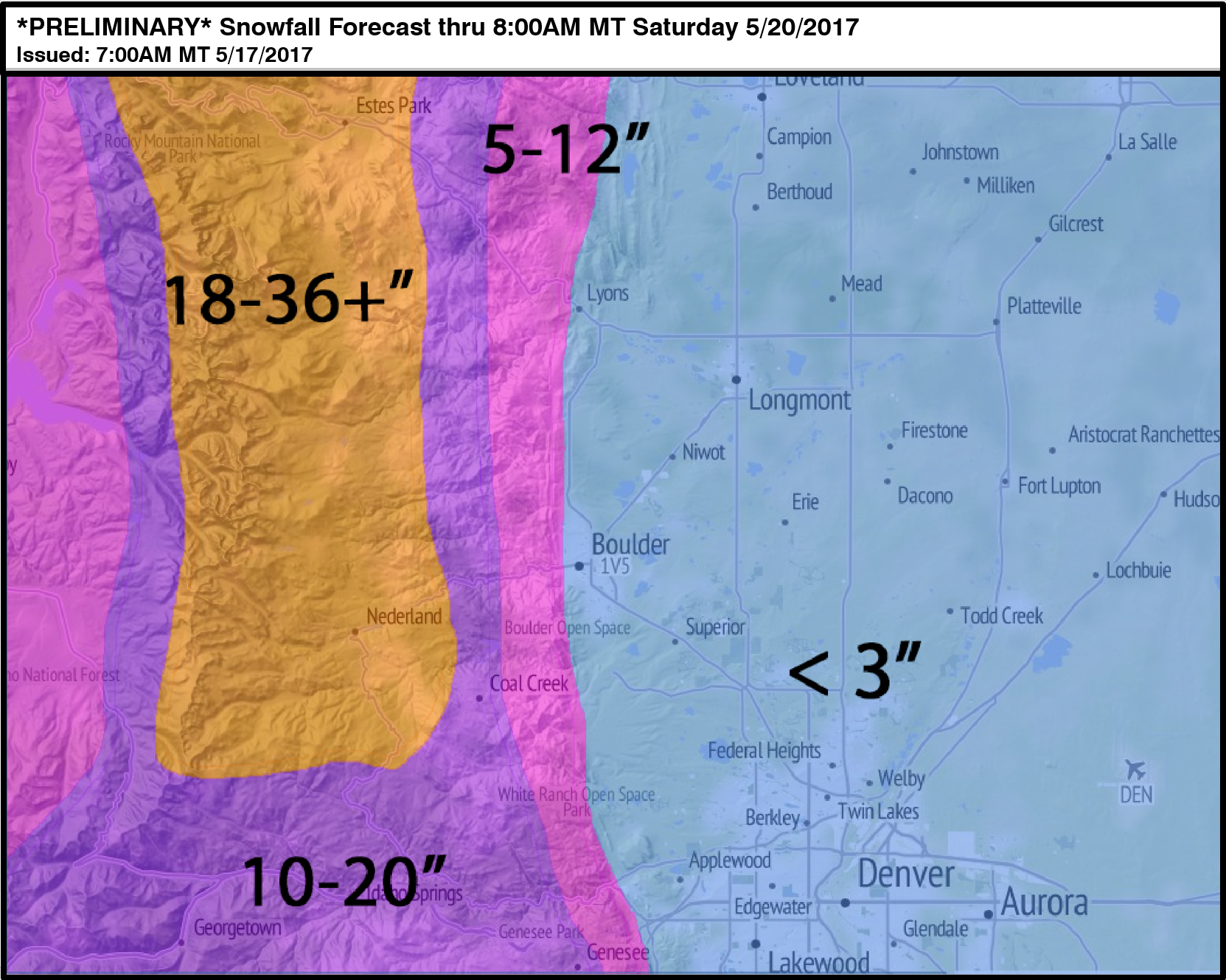
Our *PREMILINARY* snowfall map is shown below. Depending on how things evolve over the next 24 hours, we may need to make some adjustments, especially in areas right near the base of the Foothills (Boulder, Golden, Arvada, etc.).
BUST POTENTIAL: Keep in mind if temperatures trend just three or four degrees colder, heavy snow will be possible on the Plains as well. We’ve seen much crazier things happen to forecasts around here, so it can’t fully be ruled out yet. As of Wednesday morning, no signs of this yet. The margin for error is definitely thinner than we’d like it to be.
Don’t under-estimate the impacts this amount of rain could have, too. Some flooding could be possible in low-lying areas across the region, especially considering rivers and streams are already running high from melting snowpack. Stay tuned for updates…
Don’t be selfish…share our forecast with your friends!

.



Any trends for more snow at lower elevations? Snowing pretty good in Broomfield right now..
We’ll have an update posted within the hour. In short, we are bumping up totals for the Plains in lieu of slightly colder temps this morning and likely tonight.
Rest of forecast looks good.
Nice. I appreciate the response.
Dumping in Boulder. Sticking to better radiating surfaces currently
Yep….of course it was colder than the models predicted. None the less, forecast update this morning should cover things. If you’re snow now, you’ll be snow until then end !
Totals coming out of the Boulder County Foothills are already approaching two feet. Incredible!