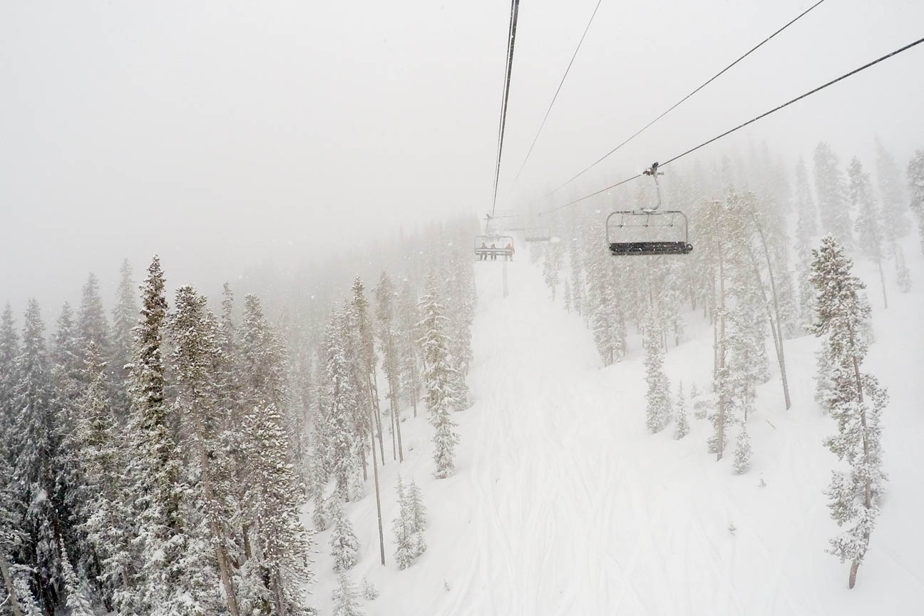
Above shows the snow over Winter Park Ski resort this past weekend due to a large upper-level low pressure system that was rotating over Nevada since last Wednesday. How much snow did the mountains get and what is the PowderCAST outlook for the week ahead? Continue for more details!
Before we go into the weekly powdercast, let’s run the numbers and tally up how much snow the resorts saw this past Thanksgiving weekend, as well as current conditions at each ski resort. You’ll notice that Beaver Creek, Winter Park, Steamboat, Vail, and Eldora wound up the leaders in snow totals for this past Holiday weekend and over the past 7 days.
Winter Park:
Current snow base: 27 inches
Base Conditions: Powder
Lifts open: 17
Last 7 days: 7 inches of snow, 73 inches so far for the season
Steamboat:
Current snow base: 23 inches
Base Conditions: Packed Powder
Lifts open: 5
Last 7 days: 9 inches of snow, 61 inches so far for the season
Vail:
Current snow base: 24 inches
Base Conditions: Powder
Lifts open: 17
Last 7 days: 7 inches of snow, 67 inches so far for the season
Keystone:
Current snow base: 24 inches
Base Conditions: Powder
Lifts open: 17
Last 7 days: 3 inches of snow, 78 inches so far for the season
Breckenridge:
Current snow base: 25 inches
Base Conditions: Packed Powder
Lifts open: 9
Last 7 days: 5 inches of snow, 64 inches so far for the season
Arapahoe Basin:
Current snow base: 27 inches
Base Conditions: Packed Powder
Lifts open: 5
Last 7 days: ~ 5 inches of snow
Loveland:
Current snow base: 26.5 inches
Base Conditions: Powder
Lifts open: 6
Last 7 days: 4 inches of snow, 97 inches so far for the season
Copper Mountain:
Current snow base: 22 inches
Base Conditions: Powder
Lifts open: 8
Last 7 days: 6 inches of snow, 62 inches so far for the season
Beaver Creek:
Current snow base: 28 inches
Base Conditions: Powder
Lifts open: 13
Last 7 days: 11 inches of snow, 68 inches so far for the season
Aspen:
Current snow base: 24 inches
Base Conditions: Powder
Lifts open: 19
Last 7 days: 4 inches of snow
Eldora:
Current snow base: 25 inches
Base Conditions: Machine made, Powder
Last 7 days: ~ 7 inches of snow
Crested Butte:
Current snow base: 19 inches
Base Conditions: Powder
Lifts open: 5
Last 7 days: 4 inches of snow, 33 inches for the year
Now let’s jump into the forecast. The forecast for today will focus on the aforementioned low pressure system, which is currently over southeastern Wyoming and northern Colorado. This system will continue to move east-northeastward from this afternoon and evening. As it does so, northwesterly flow will ensue across the High-Country. That will spell out upslope flow across the mountains with favored ski slopes being those along and north of I-70 west of the Divide. Some spill-over will also occur for areas just east of the Divide.
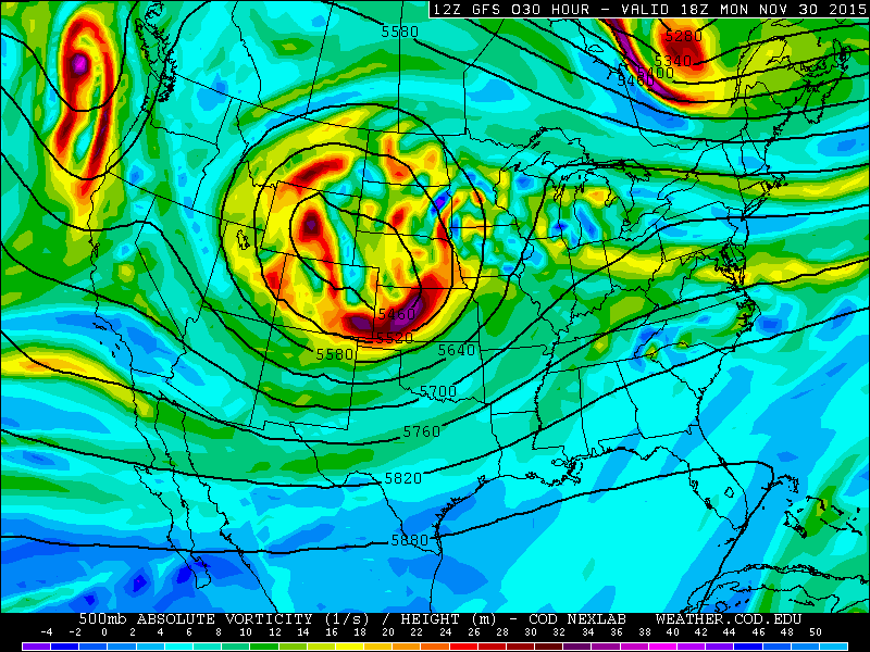
GFS 500 mb Absolute Vorticity this afternoon
Below shows the forecast precipitation from this afternoon and tonight across Colorado from the NAM model. This map shows a swath of snowfall across northwestern Colorado. The favored areas should be Steamboat, Vail, Winter Park, Beaver Creek, and Copper. Of course, this system does not look to be strong, but expect light to moderate snow showers from today into tomorrow morning. A general 2-4 inches of snow can be expected in areas along and north of I-70. This will lead to powder days for several ski resorts on Tuesday.

Forecasted radar reflectivity from the NAM for Tuesday morning
Forecast snow amounts today into Tuesday morning
| Steamboat: 3-6″ | Eldora: < 1″ | Winter Park: 2-4″ | Vail: 2-4″ |
| Beaver Creek: 2-4″ | Loveland: 1-3″ | A-Basin: 1-3″ | Keystone: ~ 1″ |
| Breckenridge: ~ 1″ | Copper Mountain: 1-2″ | Aspen/Snowmass: 1-2″ | Crested Butte: ~ 1″ |
As we go into Tuesday afternoon, through Thursday, the weather pattern relaxes with little to no major storms on the horizon. Sunny skies can be expected for the High Country Wednesday through Thursday. The next possible system would be Friday. Below shows the 500 mb vorticity from the GFS for Friday afternoon. It shows a weak trough of low pressure over southern California. This trough is expected to dive south of Colorado over the upcoming weekend. Also, moisture is limited with this system so we do not expect much of a snow threat on Friday, but will keep you updated if things change 🙂
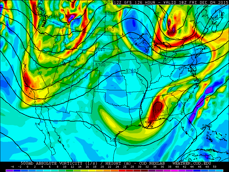
GFS 500 mb forecast for Friday


You must be logged in to post a comment.