
Winds are howling across the Foothills this morning, with gusts topping 70+ MPH and fire danger at historic levels. For the first time ever, Colorado is under a Particularly Dangerous Situation Red Flag Warning—an extraordinary designation from the National Weather Service. While Boulder itself could dodge the absolute most extreme winds, conditions remain somewhat uncertain overall, and things will definitely be highly volatile in the Foothills. We breakdown the latest model updates and step through how this dangerous Friday will unfold across the area.
A
lright folks, let’s keep this fairly tight this morning, but there’s a lot to unpack. Our extreme mountain wave wind event is already in full swing up in the Foothills. Gusts are roaring between 60 and 80 MPH just west of Boulder, reaching down to elevations around 6,000 to 6,500 feet.

NCAR Mesa lab reported a gust of 77 MPH not long ago. The rest of the lower elevations area has seen sporadic wind gusts this morning, ranging from calm up to 45 MPH.

The key update today is about how far east these extreme winds will push, and what that means for fire danger. Yesterday we noted that models were trending toward keeping the strongest winds pinned closer to the Foothills, limiting their spread into the plains. Overnight, that trend nudged a little further in that direction—just a mile or two—but even small shifts matter when you’re talking about neighborhoods right up against the base of the Foothills. For Boulder, that’s potentially good news: the odds of seeing truly damaging winds in town are lower.

That said, we’re already seeing those extreme gusts dipping down to 6,000 feet early this morning, which raises questions about whether the models are underestimating the eastward creep. If winds continue to edge east through the day, Boulder could still be in the crosshairs. It wouldn’t take much—another mile or two—and those 70+ MPH gusts will be upon us.
Based on current evidence, we’re comfortable removing Boulder proper from the extreme wind and fire danger zone. Significant gusts are still highly likely in town, especially for the western half. Impacts there could include downed trees, powerlines, and fences. The highest risk remains confined to the Foothills, western Rocky Flats along Highway 93, and elevations between roughly 5,500 and 9,000 feet. This slight reduction is not a free pass to let your guard down today. If a fire were to ignite anywhere west of Boulder, it would still experience rapid, nearly unstoppable growth towards and through town.
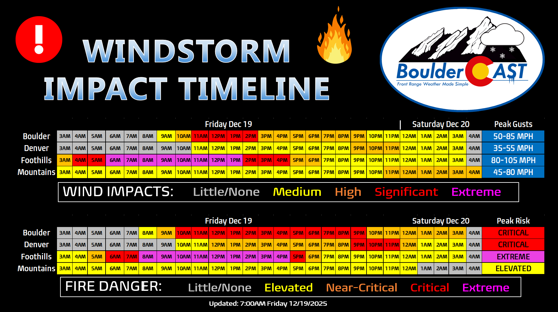
Now, the bigger picture: the entire Front Range is under a Red Flag Warning through midnight tonight. And this isn’t your typical warning—this one carries the Particularly Dangerous Situation (PDS) designation from the National Weather Service. That’s historic for Colorado; it’s the first time we’ve ever seen a PDS attached to a fire weather warning here, something which is now commonplace in California. To put it bluntly, you don’t want to be inside a PDS Warning of any kind—whether it’s for tornadoes, hurricanes, or wildfires. It signals a truly dire setup. Extremely strong winds and critical relatively humidities will overlap drought-stricken areas of the Foothills in Boulder and Jefferson Counties today for many hours. This is the region of extreme fire danger (circled areas below). If a fire ignites, it will spread with frightening speed toward the east.


Furthermore, fire danger won’t drop off after sunset like it usually does. Fire weather risk will stay moderate to high well into the evening. Low humidity and gusty winds will persist until about midnight, when a cold front and some low-level moisture finally move in. That’s when the Red Flag Warning expires, so stay fully weather aware until at least then.
As the front and moist jet stream arrive, snow will spread into the Mountains and higher Foothills tonight, with even a few rain showers possible in Boulder by Saturday morning. Yes, this is another chance for exclusively rain in December.
Expected Peak Wind Gusts
- Foothills and most wind‑prone spots (western Rocky Flats, NCAR Mesa, far west Arvada): Peak gusts of 75–105 MPH are likely, highest in the lower Foothills. High uncertainty exists for Boulder proper which will be right on the edge of the extreme wind threat.
- Most of Denver area / anywhere along I‑25: Gusts of 35–60MPH expected, most of these coming Friday evening after the mountain wave breaks.
- Farther east (DIA, Aurora, Parker): Gusts of 30–50MPH or less, mostly Friday evening after the mountain wave breaks.
Probability of a least one wind gust exceeding various thresholds within 5 miles of BOULDER (strongest in the Foothills/west side of town):
- 60 MPH: 100%
- 70 MPH: 95%
- 80 MPH: 90%
- 90 MPH: 55%
- 100 MPH: 30%
- 110 MPH: 10%
Probability of a least one wind gust exceeding various thresholds within 5 miles of DENVER:
- 60 MPH: 40%
- 70 MPH: 10%
- 80 MPH: 0%
- 90 MPH: 0%
- 100 MPH: 0%
- 110 MPH: 0%
New Daily Record Highs Likely Friday
Outside of the scary wind and fire risk, temperatures will be extremely warm on Friday, peaking around 70 degrees, close to record territory for many Front Range cities. Boulder’s December 19th record high is 69° (set in 1979), while Denver’s is 67° (set in 1917 & 2023). There will be a lot of wave cloud cover blanketing the area throughout the day, which is the only facet of the forecast that would limit how warm we’ll get.

Power Shutdowns
Here’s the latest update from Xcel regarding the Public Safety Power Shutdowns, which saw power cut to ~70,000 customers around 6:00AM this morning. Xcel mentions no definitive timeline for restoration, but it’s possible some areas could be back on Friday night, but we expect some locations will remain dark well into the weekend, especially in the Foothills. Check the Outage Map for updated information.

Given the forecast which has shifted to keep the most extreme winds largely in the Foothills, the current planned shutdown area could be too broad, leaving residents the see very little wind angry they were shut off. Not saying that is the right sentiment, but it’s definitely one we can see brewing.
Be Safe and Prepare!
Friday’s windstorm isn’t just another round of potentially damaging gusts—it’s a dangerous overlap of extreme downslope winds and critically dry air. The Foothills are staring down peak gusts in the 75–105 MPH range from the early morning through late afternoon, with relative humidities below 15% during the worst of it. That combination is primed for explosive fire growth. This is the kind of setup where even a single spark can turn into a fast‑moving blaze racing eastward across grasslands or downwind forests. Yes, just like the Marshall Fire.
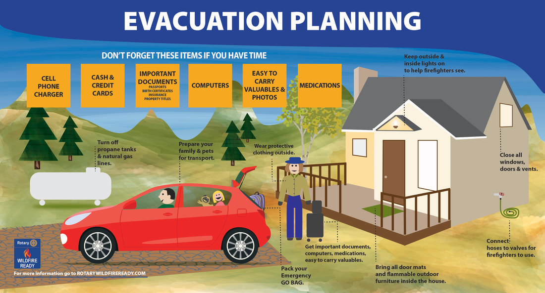
You should prepare for both wind impacts and fire danger:
- Secure your property: Tie down or bring inside anything that can blow away—patio furniture, trash bins, holiday decorations. These items can become projectiles in 80+ MPH winds. We’ve seen this already with window shattering on homes and cars on Wednesday.
- Plan for outages: Xcel has proactively shut off power in high‑risk areas starting early Friday morning. Have flashlights, batteries, and backup charging options ready. Assume outages could last well into the weekend or even longer.
- Fire safety is non‑negotiable: Absolutely no outdoor burning, grilling, or use of fire pits. Avoid smoking outdoors; if you must, do so responsibly and never discard butts outside.
- Vehicle precautions: Don’t park on tall grass or brush—hot exhaust systems can ignite dry fuels.
- Equipment awareness: Postpone any outdoor work involving tools that can spark (chainsaws, welders, grinders). Even lawnmowers can be risky in these conditions. A fire started in Boulder Open Space a few weeks ago from a lawn mower hitting gravel.
- Community vigilance: If you see smoke, call 911 immediately. Early detection is critical when winds can push flames miles in minutes.
- Evacuation readiness: Keep your go‑bag stocked and accessible. Know your neighborhood’s evacuation routes, especially if you live in the Foothills or anywhere butting up against prairie to the west.
Remember, this atmospheric setup is more primed for fire spread than the day of the Marshall Fire. The saving grace is reduced fuel abundance this year and Xcel’s proactive grid management—but that doesn’t eliminate the risk entirely.
The message is simple: we cannot afford any ignitions on Friday. Share this information with neighbors, friends, family, and coworkers. The more people understand the risk, the safer our entire community will be. Be safe!
Spread the word, share our crazy Colorado weather:

Go Premium, get all the perks.
Daily Forecast Updates
Get our daily forecast discussion every morning delivered to your inbox.
All Our Model Data
Access to all our Colorado-centric high-resolution weather model graphics. Seriously — every one!
Ski & Hiking Forecasts
6-day forecasts for all the Colorado ski resorts, plus more than 120 hiking trails, including every 14er.
Smoke Forecasts
Wildfire smoke concentration predictions up to 72 hours into the future.
Exclusive Content
Weekend outlooks every Thursday, bonus storm updates, historical data and much more!
No Advertisements
Enjoy ad-free viewing on the entire site.


You must be logged in to post a comment.