
Page 7 of 549
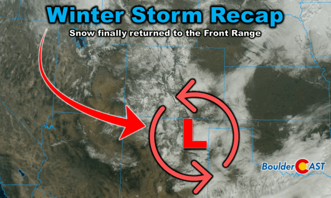
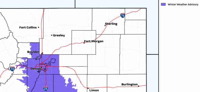
Winter finally showed up in style this week along the Front Range. After a sluggish start to the season, our first true snowstorm delivered nearly 18 hours of steady flakes, painting Boulder, Denver, and much of Colorado in white. But this wasn’t just a simple upslope event—there were some fascinating atmospheric twists that kept the snow machine running longer than expected. We review the storm setup and snowfall totals which greatly favored the western side of the Metro area including Boulder.

Snow has been falling steadily since midnight, turning the Front Range into a real winter wonderland on this Wednesday. We review the regional snowfall totals so far, and discuss the latest forecast details, including when we expect this snowstorm to loosen its grasp on the Front Range.
Snow season has finally arrived along the Front Range, and this week’s storm looks ready to deliver more than just a token dusting. After Thanksgiving’s overhyped flurries broke our snow drought, we’re now tracking a midweek system with real staying power—nearly 24 hours of upslope flow, solid moisture, and model agreement pointing to a medium‑impact event. Boulder, Denver, and the Foothills are all in line for several inches, with tricky travel expected Wednesday morning. Curious how much snow your neighborhood could see? We break down the setup, snow totals, and timing…

A few snowflakes fell across the area Sunday evening with some jet-forced snow bands around. These were largely south of Denver leaving just a trace of snow for most of us. The Mountains made out better with several inches of orographic snow piling up under moist northwesterly flow. We briefly review both the snow totals from this single storm and the seasonal ones.
Winter’s first real punch is on the way… After a quiet start to the week, all eyes turn to Wednesday as a stronger storm system sets its sights on the Front Range. Sunshine today and mild temps Tuesday won’t last long—by midweek, upslope flow and Arctic air will combine to deliver widespread snow and a chilly temperatures to the entire Denver Metro area. How much will fall, and who gets the brunt of it? We break down the latest model guidance, timing, and impacts.

Live View of Boulder

Current Conditions

Live Radar

Recent Premium Posts

BoulderCAST Daily – Sun 01/11/26 | A mild Sunday with readings reaching the 50s
🌤️ Mild & Melty Sunday: Light winds and patchy clouds, with lingering snowpack …
BoulderCAST Daily – Sat 01/10/26| Widespread sunshine and moderating temperatures this weekend as our recent snow melts off
🌤️ Calm Saturday: Winter storm systems have departed the state, leaving behind a …
BoulderCAST Daily – Fri 01/09/26| Snow ends quickly this morning with a quieter weekend in store
❄️ Overnight snow bands: A second push of upslope after midnight sparked narrow …
3-Day Forecast

Trending Content

© 2026 Front Range Weather, LLC